Report on Reventador (Ecuador) — March 2012

Bulletin of the Global Volcanism Network, vol. 37, no. 3 (March 2012)
Managing Editor: Richard Wunderman.
Reventador (Ecuador) Dome growth; lava and pyroclastic flows; lahar takes bridge
Please cite this report as:
Global Volcanism Program, 2012. Report on Reventador (Ecuador) (Wunderman, R., ed.). Bulletin of the Global Volcanism Network, 37:3. Smithsonian Institution. https://doi.org/10.5479/si.GVP.BGVN201203-352010
Reventador
Ecuador
0.077°S, 77.656°W; summit elev. 3562 m
All times are local (unless otherwise noted)
Reventador discharged a series of small eruptions and lava flows during 2007-2009 (BGVN 33:04; 33:08; 34:03; and 34:09). Our last report (BGVN 34:09) discussed events through 26 October 2009. Since then seismicity generally remained moderate to low through at least April 2012, and ash emissions accompanying lava-dome growth intermittently occurred. Much of this report stems from work by the Instituto Geofísico-Escuela Politécnica Nacional (IG). The andesitic volcano contains a 4-km summit caldera that opens to form a large U-shaped scarp that funnels material SE (see map in BGVN 28:06). A VEI 4 eruption on 3 November 2002 (BGVN 27:11) occurred unexpectedly after a 26-year repose.
During this reporting interval, October 2009-April 2012, small plumes with occasional ash emissions accompanied dome growth (table 5). In August 2011, the top of the growing lava dome first reached the same height as the highest part of the rim. MODVOLC thermal alerts, which are satellite based using the MODIS instrument, were absent during 2011, possibly due to masking effects of cloud cover. The two tallest plumes noted in table 5 rose to approximately 7 km altitude. In addition, as discussed below in text, pyroclastic flows were also seen during the reporting interval. Lahars were common, including one that destroyed a bridge over a river on the SE flank on 25 May 2010.
Table 5. Summary of behavior and plumes at Reventador between mid-October 2009 and 18 April 2012. Some aspects of the October 2009 activity were previously reported (BGVN 34:09). Cloud cover frequently prevented observations of the volcano, and minor plumes may not have been recorded or were omitted. Heights above crater were converted to altitude by adding the summit elevation of 3.6 km. '-' indicates data not reported. Data provided by the Instituto Geofísico-Escuela Politécnica Nacional (IG), the Guayaquil Meteorolgical Watch Office (MWO) in Ecuador, and the Washington Volcanic Ash Advisory Center (VAAC).
| Date | Plume altitude (km) | Plume drift direction | Remarks |
| 14 Oct 2009 | -- | -- | Increased seismicity and harmonic tremor. Residents during the middle of October heard roaring and booming noises and saw glowing. |
| 16-17 Oct 2009 | -- | -- | An IG field party saw a lava flow on the cone's S flank on the 16th and 17th. An overflight on the 16th also revealed a lava flow on the N flank. |
| 19 Oct 2009 | -- | -- | An areal infrared (FLIR) camera took images of S flank lava flows that covered a large area. A plume with little or no ash rose to 7.5 km altitude and drifted NW, W, and S. An explosion ejected glowing material from the crater and blocks rolled down the flanks. |
| 21-22 Oct 2009 | -- | -- | Aerial infrared observations again imaged the N flank lava flow, and detected multiple lobes in the S-flank flows. A part of the lava dome's base had been removed but the dome itself had gained some small spines, especially towards the S. Material near the crater had temperatures up to 400°C. |
| 05 Nov 2009 | 7 | NE | Pilot report. Ash not seen in satellite imagery, although weather clouds were present. |
| 07 Nov 2009 | 4 | -- | -- |
| 14 Nov 2009 | -- | 10-20 km W, WNW | -- |
| 20 Nov 2009 | 6.1 | -- | -- |
| 18 Feb 2010 | -- | -- | Ash not identified in satellite imagery. |
| 08 Apr 2010 | 4.6-6.7 | W | Pilot report. Cloud cover prevented satellite observation. |
| 20-23 Apr 2010 | 4.9-5.5 | S | 200-m-long pyroclastic flow seen during IG flight on 20th (see text). Plume height and direction from aviation reports on 23rd. |
| 26 Apr 2010 | 4 | -- | -- |
| 29 Apr 2010 | -- | -- | Low ash content. |
| 07 May 2010 | 5.2 | -- | Pilot report. Cloud cover prevented satellite observation. |
| 08 May 2010 | -- | -- | IG reported lahars including some that later destroyed a bridge over Marker river (see text). |
| 30 Aug 2010 | -- | -- | Pilot report. Ash not seen in satellite imagery. |
| 09 Sep 2010 | 5.5 | -- | Pilot report. |
| 28 Sep 2010 | 5.6 | NW | Ash fell on Reventador amid seismic episodes (see text). |
| 30 Sep 2010 | -- | NW | Satellite detected diffuse plume but no ash. IG reported ash over Reventador. |
| 06 Oct 2010 | -- | NE | Steam plume also emitted that day. |
| 02 Nov 2010 | 4.6 | -- | Cloud cover prevented satellite observation. |
| 04 Jan 2011 | 5.2 | -- | Ash not detected by satellite, and no reports of ashfall. IG later inferred extensive dome growth during 2011 (see text). |
| 14 Jul 2011 | -- | -- | An IG flight revealed the dome's top had reached as high as the highest point on the rim. Plumes were continuous though fumarolic (probably not ash bearing). Seismicity had started in May 2011 but became more pronounced around the start of July. |
| 03-09 Aug 2011 | -- | -- | Cloud cover hid the lava dome but IG seismic instruments recored both long-period and explosion earthquakes. |
| 06-07 Jan 2012 | -- | -- | IG field inspection revealed constant steam-and-gas emissions a lava dome that rose ten's of meters above crater rim. |
| 11 Feb 2012 | 5.2 | NW | Pilot report. IG noted that on the 12th, seismicity increased a lava flow was detected on the NE flank. |
| 16 Feb 2012 | -- | 19 km SE | Ash detected by satellite. |
| 18 Feb 2012 | 3.6 | -- | -- |
| 26 Mar 2012 | -- | 25 km NNW | -- |
| 18 Apr 2012 | 5.6 | NW | -- |
On 20 April 2010, IG scientists flying over Reventador saw an explosion that generated a pyroclastic flow. It traveled ~200 m down the S flank. Recent deposits from earlier pyroclastic flows were also seen on the same flank. Steam-and-gas emissions also continued. On 8 May 2010, IG noted a small lahar inside the caldera.
On 25 May a destructive lahar took place that was detected for 90 minutes by the seismic network. It traveled down the SE flank and destroyed a bridge over the Marker River, ~8 km SE of the summit area. The loss of the bridge disrupted travel along Route E45 between Baeza (~34 km SSW) to Lago Agrio (also called Nueva Loja, ~121 NE).
On 28 September 2010, IG recorded three seismic episodes from Reventador. Cloud cover prevented observations during the first episode. The second seismic episode was accompanied by a steam plume containing a small amount of ash that rose 400-500 m above the crater. The third episode occurred in conjunction with a steam-and-ash plume that rose 2 km above the crater. Ash fell on the flanks.
In May 2011, seismicity began to increase and became more pronounced by early July.
During an overflight on 14 July 2011, IG scientists noted that the lava dome at the top of the 2008 cone had continued to grow (figures 37 and 38). The dome had reached the same height, or higher, as the highest part of the crater rim formed during 2002 (figures 37 and 38). Intense fumarolic activity produced continuous plumes.
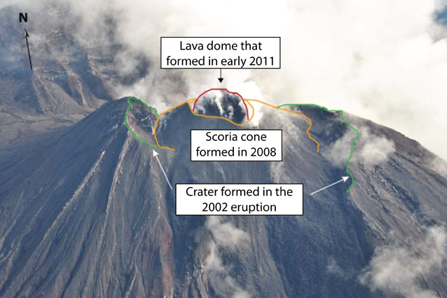 |
Figure 37. Annotated photo of Reventador taken looking NW on 14 July 2011. The green lines trace the topographic margin of the summit caldera initially formed in the sudden 2002 eruption. The conical structure outlined in orange is a scoria or tephra cone (which includes some lavas) and spills out of the breach toward the viewer. The red line outlines the dome, initially seen in 2004, that grew substantially in 2011. Courtesy of J. Bustillos/Instituto Geofísico-Escuela Politécnica Nacional. |
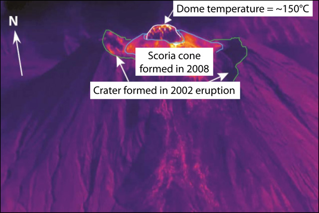 |
Figure 38. Thermal image of Reventador crater for comparison with the visual image (figure 37), also taken 14 July 2011. The measured temperature of the growing dome was ~150°C. Courtesy of S. Vallejo/Instituto Geofísico-Escuela Politécnica Nacional. |
During 3-9 August cloud cover prevented observations of the lava dome, but the seismic network detected long-period and explosion-type earthquakes.
During a field trip on 6-7 January 2012, IG staff observed constant emissions of gas and steam that originated from the growing lava dome. At this point in time the dome had broadened and stood a few ten's of meters above the crater rim.
During 10-13 February 2012, IG detected new activity, including a thermal anomaly, an ash plume, and crater incandescence. This elevated activity continued during 15-21 February. Incandescence near the summit was again observed during 25-26 March but seismicity decreased around this time.
In accordance with these other observations, occasional MODVOLC thermal alerts were posted. Between 1 November 2009-1 April 2012, there were 12 days with MODVOLC thermal alerts. No thermal alerts were detected in 2011. As of 26 April 2012, six days in 2012 had thermal alerts (10, 13, 22, 26 February, 18 March, and 26 April).
Geological Summary. Volcán El Reventador is the most frequently active of a chain of Ecuadorian volcanoes in the Cordillera Real, well east of the principal volcanic axis. The forested, dominantly andesitic stratovolcano has 4-km-wide avalanche scarp open to the E formed by edifice collapse. A young, unvegetated, cone rises from the amphitheater floor to a height comparable to the rim. It has been the source of numerous lava flows as well as explosive eruptions visible from Quito, about 90 km ESE. Frequent lahars in this region of heavy rainfall have left extensive deposits on the scarp slope. The largest recorded eruption took place in 2002, producing a 17-km-high eruption column, pyroclastic flows that traveled up to 8 km, and lava flows from summit and flank vents.
Information Contacts: Instituto Geofísico-Escuela Politécnica Nacional (IG), Casilla 17-01-2759, Quito, Ecuador (URL: http://www.igepn.edu.ec/); Guayaquil Meteorological Watch Office (MWO); Washington Volcanic Ash Advisory Center (VAAC), Satellite Analysis Branch (SAB), NOAA/NESDIS E/SP23, NOAA Science Center Room 401, 5200 Auth Rd, Camp Springs, MD 20746, USA (URL: http://www.ospo.noaa.gov/Products/atmosphere/vaac/); Hawai'i Institute of Geophysics and Planetology (HIGP), MODVOLC Thermal Alerts System, School of Ocean and Earth Science and Technology (SOEST), Univ. of Hawai'i, 2525 Correa Road, Honolulu, HI 96822, USA (URL: http://modis.higp.hawaii.edu/).