Report on Reventador (Ecuador) — June 2013

Bulletin of the Global Volcanism Network, vol. 38, no. 6 (June 2013)
Managing Editor: Richard Wunderman.
Reventador (Ecuador) Lava dome's summit rises above rim in late 2012
Please cite this report as:
Global Volcanism Program, 2013. Report on Reventador (Ecuador) (Wunderman, R., ed.). Bulletin of the Global Volcanism Network, 38:6. Smithsonian Institution. https://doi.org/10.5479/si.GVP.BGVN201306-352010
Reventador
Ecuador
0.077°S, 77.656°W; summit elev. 3562 m
All times are local (unless otherwise noted)
The last report on Reventador covered activity through 26 April 2012 (BGVN 37:03) and this one covers activity through April 2013.
In its Special Report of 9 November 2012, Ecuador's Instituto Geofísico-Escuela Politécnica Nacional (IG) summarized the new phase of activity that began in February 2012. The Special Report noted that lava flows traveled as far as 2 km from the crater down the N and S flanks. Later reports noted that in November-December 2012, lava flows reached 1.3 km in length; in January 2013 they reached up to 1.1 km in length. During this reporting interval, ash plumes rose as high as 5.2 km altitude both in August 2012 and November 2013.
The lava dome in the interior of the crater continued to grow and between November 2012 and January 2013 established a new summit that reached to at least 100 m above the E rim, having completely filled the crater developed in November 2002. This enabled blocks from the lava dome to roll down the flanks.
Table 6. A non-comprehensive synthesis of Reventador's steam and ash plumes generated during the reporting period. Courtesy of IG and the Washington VAAC.
| Date | Plume altitude OR height above (3.5 km a.s.l.) rim / direction / distance | Comments |
| 11 Aug 2012 | Ash plume rising to 5.2 km trended W | -- |
| 20 Sep 2012 | Ash plume drifted 22 km SW | -- |
| 17-18 Oct 2012 | Steam and gas plume rose to 1 km and trended W | -- |
| 3-4 Nov 2012 | Steam and ash plume rose to 3 km above the crater. | -- |
| 5 Nov 2012 | Steam and ash plume rose to 3 km; ash plume rose to 2 km and drifted NW | -- |
| 13 Nov 2012 | Gas and ash plume rose to 5.2 km and drifted SE | -- |
| 16 Nov 2012 | Ash plume rose to 4 km above the rim and drifted W and NW | Ashfall reported between Reventador and El Chaco (35 km SSW) |
| 22 January 2013 | Gas and steam plume rose 1.5 km above the crater; white-to-light grey plumes rose 2 km and drifted W | -- |
| 24 January 2013 | Steam and ash plume rose 2 km | -- |
| 29 January 2013 | Gas plumes rose as high as 1 km and drifted NW and W | -- |
| 29 January 2013 | Overflight revealed steam and ash plume rising to 1.5 km above the lava dome; | -- |
| 4 February 2013 | Ash plume rose to 4 km and drifted NW | -- |
| 7 February 2013 | Ash plume rose to 3 km and drifted S | -- |
| 2 March 2013 | Ash plume rose to 4 km and drifted SW | -- |
| 8 March 2013 | Steam emission rose to 500 above the crater | Glow reported |
| 12 March 2013 | Emission rose to 2 km and drifted W | -- |
| 13 March 2013 | Ash plumes rose to 3 km | -- |
| 16 March 2013 | Ash plume rose to 1 km and drifted W | -- |
| 31 March 2013 | Steam emission rose to 500 above the crater and trended W | -- |
| 8 April 2013 | Emissions reached to 3 km above the crater | -- |
| 12 April 2013 | Steam emissions reached to 2 km | -- |
Between late April and early August 2012, activity at Reventador remained moderate, and although cloud cover often obscured visual observations, there were occasional reports of steam emissions rising to as high as 1 km above the crater. Long-period (LP) earthquakes occurred with moderate-to-high intensity, a behavior interpreted as the movement of fluids at depths. Seismic signals attributed to rock fall were also prominent, inferred to come from lava flows that descended the N flank, as aerial observers witnessed on both 29 May and 4 June.
Based on analysis of satellite imagery, the Washington Volcanic Ash Advisory Center (VAAC) reported that on 12 August they detected a well-defined thermal anomaly. Thermal images obtained in overflights carried out on 17 and 18 October 2012 revealed a lava flow that descended the flank of the cone and verified that another flow had descended during the preceding days or weeks and at the moment of observation was still warm. The flows did not exceed 1 km in length, and in light of their location within the crater, were not a danger to the public (figure 39).
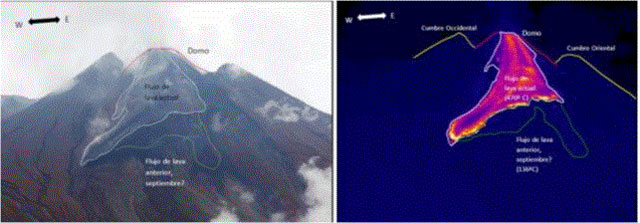 |
Figure 39. A) On the left photo, the S flank of Reventador seen on 19 October 2012. A lava flow descending on the upper flank covered much of the flows from previous days and weeks. At right is a corresponding thermal image, permitting definition of the extent of the new hotter flows. Photo and image, courtesy of P. Ramon (Instituto Geofisico). |
On 17 and 18 October, IG also verified the presence of a previously known lava dome within the crater, with steep slopes, the top of which was then the highest point of the volcano. Similar observations were carried out on 19 October by IGEPN technicians maintaining the monitoring network, who also stressed the continuous flow of lava blocks spilling off both the fronts of new flows and from the lava dome.
During 31 October-11 December 2012, the IG reported that although cloud cover often prevented visual observations, ash plumes were often seen.
Seismicity increased during this time period. Around 5 November, the seismic network detected an increase in the magnitude of volcanic tremor. IG reported that seismicity indicated falling rock and explosions during 14-15 November. Beginning 16 November IG's seismic network indicated a significant increase in tremor and in signals indicative of emissions and explosions. IG reported that scientists aboard an overflight on 23 November observed intense fumarolic activity and a new crater at the summit of the dome, which contained ash and large blocks. A thermal camera measured temperatures at the dome of ~ 300°C. Lava flows continued to be active on the dome flanks, and elongated block-and-ash deposits were also visible on the flanks. IG reported high seismicity during 5-11 December 2012, indicating multiple explosions almost daily. At least one lava flow was generated between November - December 2012 that descended the N flank to ~1.3 km in length.
2013. Throughout this January-April 2013 reporting period, cloud cover often prevented visual surface observations. The lava dome grew between November 2012 through January 2013 to at least 100 m above the E rim, completely filling the crater generated by the eruption of November 2002. Between November 2002 and 31 January 2013, ~ 20 lava flows had traveled down the N, SE, and S flanks, and affected zones within the caldera.
IG reported moderate seismicity during 16-21 January 2013. During the morning of 22 January seismicity, including tremor, increased significantly, signals indicating that rock falls were detected. Low frequency, high-energy tremor was detected by seismic stations around the volcano with an average of 20 seismic events and an average of 29 explosions. Explosions were heard. Lava flows traveled down the SW and N flanks. Observers reported lava fountains in the crater and lava flows on the flanks, both of which became more intense at 1800. Explosions produced white-to-light-gray plumes that rose 2 km and drifted W (figure 40).
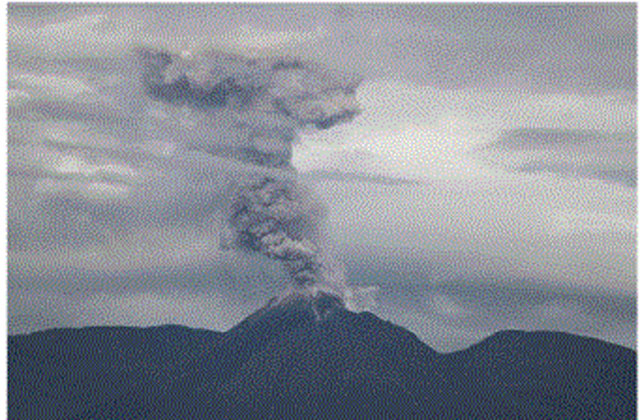 |
Figure 40. Emission column seen late in the day on 22 January 2013 associated with the explosive activity at Reventador. Courtesy Walter Garcia Synohidro and Instituto Geofisico. |
During the night of 22 January a lava flow descending the SE flank had reached a width of 350 m and extended at least 1.1 km (figure 41). Other smaller lava flows up to 200 m long were observed on the N and S flanks.
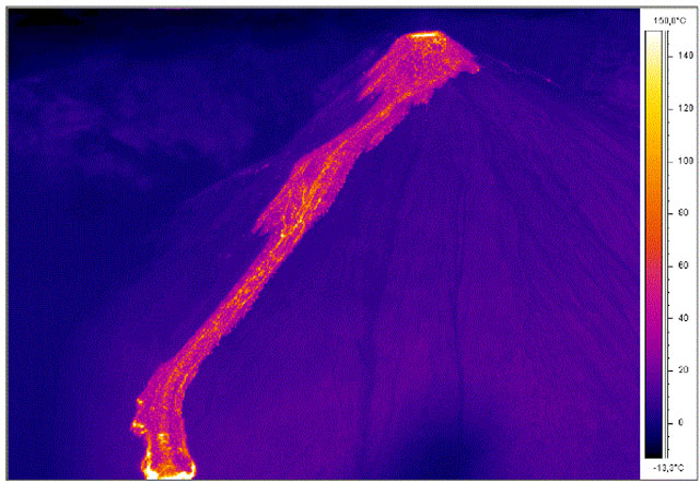 |
Figure 41. Thermal image of Reventador on 22 January 2013 shows the dome from which a lava flow descends to the SE. Courtesy S. Vallejo, Instituto Geofisico (IG-EPN). |
During 23 January-7 February 2013 seismicity remained high. Lava flows were visible at night. Crater incandescence was observed at night during 29-30 January.
IG reported that seismicity became more moderate during 8-12 February; explosions were detected daily. Ashfall was reported in areas near the volcano on 9 February. Between 16-20 February, activity remained moderate, with continued ash emissions, but an absence of reported ashfall. For the remainder of February 2013, no reports of surface activity were received, and seismic signals ceased transmission.
According to the Washington VAAC, the IG reported that on 2 March lava flows were observed. IG reported that the seismic network recorded multiple explosions during 13-17 March. Observers reported falling and rolling incandescent material on Reventador's S flanks on 12 March. On 15 and 17 March explosions were detected by the seismic network. IG characterized activity as being at a moderate level for most of the remainder of March.
IG noted that moderate activity continued into April 2013 (table 6). Through 12 April seismicity remained moderate. On 15 April IG reported an increase in the number of seismic events. Seismic and surface activity remained moderate to high through 24 April, but became more moderate thereafter and remained so for the remainder of April 2013.
Geological Summary. Volcán El Reventador is the most frequently active of a chain of Ecuadorian volcanoes in the Cordillera Real, well east of the principal volcanic axis. The forested, dominantly andesitic stratovolcano has 4-km-wide avalanche scarp open to the E formed by edifice collapse. A young, unvegetated, cone rises from the amphitheater floor to a height comparable to the rim. It has been the source of numerous lava flows as well as explosive eruptions visible from Quito, about 90 km ESE. Frequent lahars in this region of heavy rainfall have left extensive deposits on the scarp slope. The largest recorded eruption took place in 2002, producing a 17-km-high eruption column, pyroclastic flows that traveled up to 8 km, and lava flows from summit and flank vents.
Information Contacts: Instituto Geofísico-Escuela Politécnica Nacional (IG), Casilla 17-01-2759, Quito, Ecuador (URL: http://www.igepn.edu.ec/); and Washington Volcanic Ash Advisory Center (VAAC), Satellite Analysis Branch (SAB), NOAA/NESDIS E/SP23, NOAA Science Center Room 401, 5200 Auth Rd, Camp Springs, MD 20746, USA (URL: http://www.ospo.noaa.gov/Products/atmosphere/vaac/).