Report on Dieng Volcanic Complex (Indonesia) — August 2013
Bulletin of the Global Volcanism Network, vol. 38, no. 8 (August 2013)
Managing Editor: Richard Wunderman.
Dieng Volcanic Complex (Indonesia) Alert Level raised due to gas emissions; moderate earthquake felt
Please cite this report as:
Global Volcanism Program, 2013. Report on Dieng Volcanic Complex (Indonesia) (Wunderman, R., ed.). Bulletin of the Global Volcanism Network, 38:8. Smithsonian Institution. https://doi.org/10.5479/si.GVP.BGVN201308-263200
Dieng Volcanic Complex
Indonesia
7.2°S, 109.879°E; summit elev. 2565 m
All times are local (unless otherwise noted)
The Center of Volcanology and Geological Hazard Mitigation (CVGHM) reported that during 7-11 March 2013 instruments monitoring the Dieng Volcanic Complex detected carbon dioxide (CO2) plumes from Timbang Crater, a cone that is part of the Dieng Volcanic Complex (see figure 2 in BGVN 36:06), drifting 50-200 m S. A strong sulfur odor was also reported, along with dead animals near the crater on 7 March. Observers noted white plumes rising from the crater that were diffuse during 7-8 March and dense during 9-10 March; the concentration increased during 9-10 March 2013. Because of the increase of CO2 emissions, CVGHM raised the Alert Status, which spans a scale of 1 to 4, from 1 (aktif - normal) to 2 (waspada - alert) on 13 March, and warned the public not to approach Timbang Crater within a 500 m radius. The last eruption reported from Dieng was 27 September 2009 at Sileri crater (BGVN 34:08; see figure 2 in BGVN 36:06). Table 4 shows the most recent Alert Levels for Dieng.
Table 4. Most recent Alert Levels reported for Dieng. Courtesy of CVGHM.
| Date of Level change | Alert Level |
| 01 Sep 2011 | 1 |
| 11 Mar 2013 | 2 |
| 27 Mar 2013 | 3 |
| 08 May 2013 | 2 |
During 10-26 March 2013 gas emissions continued to be elevated at Timbang crater. Plumes containing CO2 and hydrogen sulfide (H2S) drifted 2 km, and were at toxic levels at a distance of 550 m. Seismicity increased during 13-26 March 2013 and then significantly increased on 27 March. CVGHM raised the Alert Level to 3 (siaga - standby) on 27 March 2013 and warned the public not to approach Timbang Crater within a 1 km radius.
On 28 March 2013 gas emissions continued to raise at Timbang. Plumes containing carbon dioxide (CO2) drifted 2 km towards the S valley of Kali Sat, prompting a road closure until the early evening when the gas concentration decreased. On 30 March 2013 CO2 gas emissions were not detected; however, 'smoke' rose at most 100 m above the crater, and hydrogen sulfide (H2S) odors were very potent in areas 1 km W and weak in areas 1.5 km S.
On 24 March 2013 Sileri Crater lake water changed from dark gray to brown, and on 7 April white plumes rose 50 m and the water color returned to normal. Diffuse white plumes rose 15 m on 20 April. Other craters had not exhibited any changes by 28 April 2013.
On 19 April sulfur dioxide (SO2) odors were reported. According to CVGHM, an M 4.8 earthquake occurred ~14 km SSW of Dieng and ~8 km NNW of Wonosobo at 1900 local time on 19 April 2013. It had a hypocentral depth of 10 km, was of a tectonic nature, but with possible influence on Dieng volcano. Eighty-six weaker quakes followed the main shock within 25 minutes. No buildings collapsed due to the earthquake, but at least 311 houses were damaged, 34 of them severely and 27 of them moderately. Two people were injured. As a precaution associated with a potential eruption, approximately 1,000 people were evacuated; they were returning to their villages by 21 April due to a decrease in volcanic activity of the Dieng volcano complex.
Based on gas concentrations, seismicity, and visual observations, CVGHM lowered the Alert Level to 2 on 8 May 2013.
Residents living in the vicinity of Dieng (close to Mt. Sundoro and Mt. Sumbing) on Java (see figure 1 in BGVN 33:11), were the subject of a study of people's perceptions and reactions to volcanic hazards (Lavigne and others, 2008).
Reference: Lavigne, F., De Coster, B., Juvin, N., Flohic, F., Gaillard, J-C., Texier, P., Morin, J., and Sartohadi, J., 2008, People's behaviour in the face of volcanic hazards: Perspectives from Javanese communities, Indonesia, Journal of Volcanology and Geothermal Research, v.172, issue 3-4, p. 273-287.
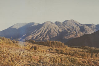
Geological Summary. The Dieng plateau in the highlands of central Java is renowned both for the variety of its volcanic scenery and as a sacred area housing Java's oldest Hindu temples, dating back to the 9th century CE. The Dieng Volcanic Complex consists of multiple stratovolcanoes and more than 20 small Pleistocene-to-Holocene craters and cones over a 6 x 14 km area. Prahu stratovolcano was truncated by a large Pleistocene caldera, which was subsequently filled by a series of cones, lava domes, and craters, many containing lakes. Lava flows cover much of the plateau, but observed activity has been restricted to minor phreatic eruptions. Gas emissions are a hazard at several craters and have caused fatalities. There are abundant thermal features and high heat flow across the area.
Information Contacts: Center of Volcanology and Geological Hazard Mitigation (CVGHM) (Pusat Vulkanologi dan Mitigasi Bencana Geologi (PVMBG)), Jalan Diponegoro 57, Bandung 40122, Indonesia (URL: http://vsi.esdm.go.id/).