The Pusat Vulkanologi dan Mitigasi Bencana Geologi (PVMBG) reported that unrest continued at the Dieng Volcanic Complex during 11-17 June. The Alert Level remained at 2 (on a scale of 1-4) and the public was warned to stay 500 m away from Sileri Crater, to not approach Timbang Crater, and to be vigilant when digging in the area due to risks of carbon dioxide gas exposure.
Source: Pusat Vulkanologi dan Mitigasi Bencana Geologi (PVMBG, also known as CVGHM)
Phreatic explosion on 29 April 2021
Infrequent phreatic explosions have occurred at the Sileri Crater Lake in the Dieng Volcanic Complex, with three explosions between 30 April and 2 July 2017, and one on 1 April 2018 (BGVN 42:10, 43:05). None were reported in 2019 and 2020. The volcano is monitored by the Pusat Vulkanologi dan Mitigasi Bencana Geologi (PVMBG, also known as Centre for Volcanology and Geological Hazard Mitigation or CVGHM).
PVMBG reported that a phreatic explosion at the Sileri Crater Lake occurred at 1825 on 29 April 2021, ejecting rocks 200 m S and E and mud 400 m S and 300 m E. According to a news article, a local road was temporarily closed because rocks (about 10 cm in diameter) from the explosion were scattered along the road and the mud made conditions slippery. The closest residents are 1 km away. The Alert Level remained at 1 (on a scale of 1-4), and the public was warned to stay 500 m away from the crater rim.
Information Contacts: Pusat Vulkanologi dan Mitigasi Bencana Geologi (PVMBG, also known as Indonesian Center for Volcanology and Geological Hazard Mitigation, CVGHM), Jalan Diponegoro 57, Bandung 40122, Indonesia (URL: http://www.vsi.esdm.go.id/); Detik News (URL: https://news.detik.com/).
2025: January
| June
2024: December
2023: January
| March
2021: April
| July
2018: March
2017: June
| September
2014: August
2013: March
| May
2011: May
| June
2009: January
| September
2005: May
2003: July
2002: April
The Pusat Vulkanologi dan Mitigasi Bencana Geologi (PVMBG) reported that unrest continued at the Dieng Volcanic Complex during 11-17 June. The Alert Level remained at 2 (on a scale of 1-4) and the public was warned to stay 500 m away from Sileri Crater, to not approach Timbang Crater, and to be vigilant when digging in the area due to risks of carbon dioxide gas exposure.
Source: Pusat Vulkanologi dan Mitigasi Bencana Geologi (PVMBG, also known as CVGHM)
In a special report for the Dieng Volcanic Complex issued on 4 June the Pusat Vulkanologi dan Mitigasi Bencana Geologi (PVMBG) noted that carbon dioxide gas concentrations at Timbang Crater began to increase on 29 May. Seismicity did not increase. The Alert Level remained at 2 (on a scale of 1-4) and the public was warned to stay 500 m away from Sileri Crater, to not approach Timbang Crater, and to be vigilant when digging in the area due to risks of carbon dioxide gas exposure.
Source: Pusat Vulkanologi dan Mitigasi Bencana Geologi (PVMBG, also known as CVGHM)
The Pusat Vulkanologi dan Mitigasi Bencana Geologi (PVMBG) reported that a phreatic eruption occurred from the E part of Sileri Crater in the Dieng Volcanic Complex on 18 December [Correction: on 6 January] and was not preceded by significant signs of elevated volcanic activity. The eruption began at 1058 and lasted for almost 57 seconds based on seismic data. Mud was ejected about 50 m N and NW, about 25 m W, and about 5 m S. A dense white plume rose 70 m above the water’s surface. During a post inspection of the crater scientists noted that volcanic gases remained at normal levels and white plumes rose 20-40 m above the water. The Alert Level remained at 2 (on a scale of 1-4). The public was warned to stay 500 m away from Sileri Crater and not to spend the night around the crater, to stay out of Timbang Crater and other potentially hazardous craters, and to take caution when digging in the ground as gasses could be released.
Source: Pusat Vulkanologi dan Mitigasi Bencana Geologi (PVMBG, also known as CVGHM)
The Pusat Vulkanologi dan Mitigasi Bencana Geologi (PVMBG) reported that a phreatic eruption occurred from the E part of Sileri Crater in the Dieng Volcanic Complex on 18 December and was not preceded by significant signs of elevated volcanic activity. The eruption began at 1512 and lasted for three minutes and 20 seconds based on seismic data. Sediment and mud were ejected about 100 m N and E, about 25 m W, and about 10 m S. An eruption plume was partially hidden due to inclement weather conditions, but observers reported seeing a white plume rise 10 m. After the eruption white plumes rose as high as 40 m above the crater. The water temperature of the lake did not increase. The water color varied in different locations appearing clear, greenish, or light-to-blackish gray, and the volume was lower. Sediment and mud deposits ringed the crater and there was a notable sulfur odor. Primary hazards at Dieng included phreatic eruptions at Sileri, Siglagah, Pagerkandang, and Candradimuka craters, along with the emission of volcanic gases at several more craters that could affect people nearby. Based on the data and potential hazards at the complex, PVMBG raised the Alert Level to 2 (on a scale of 1-4) at 1800 on 19 December. The public was warned to stay 500 m away from Sileri Crater and not to spend the night around the crater, to stay out of Timbang Crater and other potentially hazardous craters, and to take caution when digging in the ground as gasses could be released. PVMBG conducted an inspection of the crater on 22 December and noted that monitoring parameters (visual, temperature, gas, and seismicity) were at normal levels. The team also visited other craters including Sikendang-Telagawarna Crater, Sikidang Crater, and Candradimuka Crater. There was no increased activity at the craters, though some gas concentrations remained at relatively high levels near or around the gas vents.
Source: Pusat Vulkanologi dan Mitigasi Bencana Geologi (PVMBG, also known as CVGHM)
On 6 March PVMBG lowered the Alert Level for the Dieng Volcanic Complex to 1 (on a scale of 1-4) due to decreased carbon dioxide emissions. During the first half of January carbon dioxide emissions were elevated at Timbang Crater and then significantly increased in mid-January; recent measurements indicated a decreasing trend. On 22 February a mobile instrument measured 112,000 ppm CO2 at the crater, though the concentration dropped to 9,200 ppm at a distance of less than 10 m from the crater rim. Measurements at the multi-gas station indicated concentration of 1,500-1,900 parts per million (ppm). The public was warned to stay 500 m away from Sileri Crater and to stay out of Timbang Crater, and to take caution when digging in the ground as gasses could be released from the soil.
Source: Pusat Vulkanologi dan Mitigasi Bencana Geologi (PVMBG, also known as CVGHM)
PVMBG reported that white gas plumes of varying densities rose as high as 80 m above the summit of the Dieng Volcanic Complex during 18-24 January. Carbon dioxide emission averages decreased from an average of 3,300 parts per million during 18-19 January to an average of 1,900 parts per million during 22-23 January. The Alert Level remained at 2 (on a scale of 1-4) and the public was warned to stay 1 km away from Sileri Crater and 500 m away from the SE, S, and SW sectors of Timbang Crater.
Source: Pusat Vulkanologi dan Mitigasi Bencana Geologi (PVMBG, also known as CVGHM)
PVMBG reported increasing activity at Dieng Volcanic Complex in a press release posted on 14 January. The number of deep volcanic earthquakes and local tectonic earthquakes had been increasing starting on 9 January. Carbon dioxide gas concentrations at Timbang Crater also intensified, averaging 0.09-0.11 percent during 1-13 January. Primary hazards at Dieng included phreatic eruptions at Sileri Crater and flows of carbon dioxide gas that can impact residents and tourists. Based on the data and potential hazards at the complex, PVMBG raised the Alert Level to 2 (on a scale of 1-4) and warned the public to stay 1 km away from Sileri Crater and to stay out of Timbang Crater, and to take caution when digging in the ground as gasses could be released.
At 2116 on 15 January carbon dioxide emissions significantly increased. The carbon dioxide gas concentration at 0027 on 16 January was 5,600 parts per million (ppm), rising to 7,300 ppm by 0130. The mobile instrument measuring the gas was located 170 m from the midpoint of Timbang Crater. At 0540 the gas concentration was as high as 10,000 ppm, measured from 130 m away from the crater’s midpoint. In a second press release, PVMBG warned the public to stay 500 m away from the SE, S, and SW sectors of Timbang Crater.
Source: Pusat Vulkanologi dan Mitigasi Bencana Geologi (PVMBG, also known as CVGHM)
PVMBG reported that on 30 July a burst of mud originated from the Siglagah thermal feature (Dieng Volcanic Complex), located on a steep hill, about 1 km NE of the center of Pagerkandang cone. The event caused an audible banging noise and sent a mudflow, 1-3 m thick, 10 m N. Observers that had visited the site in July saw gas emissions rising 10-30 m high and occasionally heard “bursting” noises up to 100 m away. The event was not accompanied by an increase in seismicity; the Alert Level remained at 1 (on a scale of 1-4), and the public was warned to stay away from the thermal area.
Source: Pusat Vulkanologi dan Mitigasi Bencana Geologi (PVMBG, also known as CVGHM)
PVMBG reported that a phreatic eruption at the Sileri Crater lake (Dieng Volcanic Complex) occurred at 1825 on 29 April, ejecting rocks 200 m S and E and mud 400 m S and 300 m E. According to a news article a local road was temporarily closed because rocks (about 10 cm in diameter) from the eruption were scattered along the road and the mud made conditions slippery. The closest residents are 1 km away. The Alert Level remained at 1 (on a scale of 1-4), and the public was warned to stay 500 m away from the crater rim.
Sources: Pusat Vulkanologi dan Mitigasi Bencana Geologi (PVMBG, also known as CVGHM); Detik News
PVMBG reported that a phreatic eruption at the Sileri Crater lake (Dieng Volcanic Complex) occurred at 1342 on 1 April, ejecting mud and material 150 m high, and up to 200 m in multiple directions. The event was preceded by black emissions that rose 90 m, and then diffuse white emissions that rose 150 m. The report noted that there were not many tourists in the area due to rainy weather; tourists are not permitted within 200 m of the crater rim.
Source: Pusat Vulkanologi dan Mitigasi Bencana Geologi (PVMBG, also known as CVGHM)
PVMBG reported that since 20 September tremor and water temperature at Sileri Crater lake (Dieng Volcanic Complex) both declined. The Alert Level was lowered to 1 (on a scale of 1-4) on 2 October. PVMBG warned the public to stay at least 100 m away from the crater rim.
Source: Pusat Vulkanologi dan Mitigasi Bencana Geologi (PVMBG, also known as CVGHM)
PVMBG reported that during 8 July-14 September measurements indicated an increase in water temperature at Sileri Crater lake (Dieng Volcanic Complex) from 90.7 to 93.5 degrees Celsius. Soil temperatures also increased, from 58.6 to 69.4 degrees Celsius. At Timbang Crater temperatures in the lake increased from 57.3 to 62.7, and in the soil they decreased from 18.6 to 17.2. The report noted that conditions at Timbang Crater were normal. Temperature increases at Sileri, along with tremor detected during 13-14 September, prompted PVMBG to raise the Alert Level to 2 (on a scale of 1-4). PVMBG warned the public to stay at least 1 km away from the crater rim, and for residents living within that radius to evacuate.
Source: Pusat Vulkanologi dan Mitigasi Bencana Geologi (PVMBG, also known as CVGHM)
BNPB reported that a phreatic eruption at the Sileri Crater lake (Dieng Volcanic Complex) occurred at 1154 on 2 July, ejecting mud and material 150 m high, and 50 m to the N and S. The event injured 11 of 18 tourists that were near the crater. According to a news article a helicopter on the way to help evacuated people after the event crashed, killing all eight people (four crewmen and four rescuers) on board.
PVMBG scientists visited the next day and observed weak white emissions rising 60 m. The report noted other events during the recent past; an event at 1303 on 30 April ejected material 10 m high and 1 m past the crater edge that formed a 1-2 mm thick deposit, and an emission at 0941 on 24 May consisting of gas and black “smoke” that rose 20 m. The Alert Level remained at 1 (on a scale of 1-4) and PVMBG warned the public not to approach Sileri Crater within a 100-m radius.
Sources: Badan Nacional Penanggulangan Bencana (BNPB); Pusat Vulkanologi dan Mitigasi Bencana Geologi (PVMBG, also known as CVGHM); ABC News - American Broadcasting Corporation; Associated Press
PVMBG noted that due to decreased activity and no observable flow of gas in high concentrations from the crater the Alert Level for Dieng was lowered to 1 (on a scale of 1-4) on 11 August. Residents and visitors were advised to not enter the crater and to be vigilant if excavating to depths greater than 1 m around the crater.
Source: Pusat Vulkanologi dan Mitigasi Bencana Geologi (PVMBG, also known as CVGHM)
CVGHM reported that on 28 March gas emissions continued to be elevated at Timbang, a cone that is part of the Dieng Volcanic Complex. Plumes containing carbon dioxide drifted 2 km towards the S valley of Kali Sat, prompting a road closure until the early evening when the gas concentration decreased. On 30 March carbon dioxide gas emissions were not detected; however, "smoke" rose at most 100 m above the crater. Hydrogen sulfide odors were very potent in areas 1 km W and weak in areas 1.5 km S. On 19 April sulfur dioxide odors were reported.
On 24 March Sileri Crater lake water changed from dark gray to brown. On 7 April white plumes rose 50 m and the water color returned to normal. Diffuse white plumes rose 15 m on 20 April. Other craters had not exhibited any changes by 28 April.
Based on gas concentrations, seismicity, and visual observations, CVGHM raised the Alert Level to 3 (on a scale of 1-4) on 8 May and warned the public not to approach Timbang Crater within a 500-m radius.
Source: Pusat Vulkanologi dan Mitigasi Bencana Geologi (PVMBG, also known as CVGHM)
CVGHM reported that during 10-26 March gas emissions continued to be elevated at Timbang, a cone that is part of the Dieng Volcanic Complex. Plumes containing carbon dioxide and hydrogen sulfide drifted 2 km, and were toxic at a distance of 550 m. Seismicity increased during 13-26 March and then significantly increased on 27 March. CVGHM raised the Alert Level to 3 (on a scale of 1-4) on 27 March and warned the public not to approach Timbang Crater within a 1 km radius.
Source: Pusat Vulkanologi dan Mitigasi Bencana Geologi (PVMBG, also known as CVGHM)
CVGHM reported that during 7-11 March instruments monitoring the Dieng Volcanic Complex detected carbon dioxide plumes from Timbang Crater drifting 50-200 m S; the concentration increased during 9-10 March. A strong sulfur odor was also reported, along with dead animals near the crater on 7 March. Observers noted white plumes rising from the crater that were diffuse during 7-8 March and dense during 9-10 March. Because of the increase of carbon dioxide emissions, CVGHM raised the Alert Level to 2 (on a scale of 1-4) on 11 March and warned the public not to approach Timbang Crater within a 500 m radius.
Source: Pusat Vulkanologi dan Mitigasi Bencana Geologi (PVMBG, also known as CVGHM)
CVGHM reported that during 31 May-10 June carbon dioxide gas emissions declined from Timbang, a cone that is part of the Dieng Volcanic Complex. Seismicity decreased during 5-7 June and was not detected during 8-10 June. White plumes were not observed. On 10 June the Alert Level was lowered to 2 (on a scale of 1-4).
Source: Pusat Vulkanologi dan Mitigasi Bencana Geologi (PVMBG, also known as CVGHM)
CVGHM reported that during 29 May-5 June carbon dioxide gas emissions from Timbang, a cone that is part of the Dieng Volcanic Complex, remained elevated. Seismicity for Dieng also remained high. During 4-5 June white plumes from Sileri crater rose 20-60 m high and white plumes from Timbang rose only 2 m and drifted 300 m S. The Alert Level remained at 3 (on a scale of 1-4).
Source: Pusat Vulkanologi dan Mitigasi Bencana Geologi (PVMBG, also known as CVGHM)
CVGHM reported that on 29 May gas plumes rose 50 m above Timbang, a cone that is part of the Dieng Volcanic Complex. The gas plumes drifted S through the valley. Observers who visited the cone noted damaged vegetation and dead birds. Seismicity and carbon dioxide gas emissions remained elevated. CVGHM raised the Alert Level to 3 (on a scale of 1-4). According to news articles, about 1,200 people were evacuated from the flanks.
Sources: Pusat Vulkanologi dan Mitigasi Bencana Geologi (PVMBG, also known as CVGHM); People's Daily Online (China)
CVGHM reported that during 18-22 May seismicity at Dieng Volcanic Complex increased. On 22 May diffuse white plumes rose 20 m from the Timbang cone; plumes from the cone had not been previously observed. The next day carbon dioxide gas emissions increased. CVGHM raised the Alert Level to 2 (on a scale of 1-4).
Source: Pusat Vulkanologi dan Mitigasi Bencana Geologi (PVMBG, also known as CVGHM)
CVGHM reported that on 26 September a "thunderous" noise from Dieng was heard from 2 km away. The next day, a phreatic eruption from an unspecified crater ejected mud as far away as 140 m S. The deposits were as thick as 10 cm near the vent and 1 cm near the farthest point. The Alert Level remained at 1 (on a scale of 1-4).
Source: Pusat Vulkanologi dan Mitigasi Bencana Geologi (PVMBG, also known as CVGHM)
CVGHM reported on 22 January that field observations of Dieng's Sibanteng crater revealed that deposits from a 15 January landslide (of an estimated total volume of 40,000 cubic meters) had covered the vent and triggered a phreatic eruption. The landslide deposits near the vent were covered by tephra from the 15 January eruption.
Source: Pusat Vulkanologi dan Mitigasi Bencana Geologi (PVMBG, also known as CVGHM)
CVGHM reported that on 15 January two minor phreatic eruptions from Dieng's Sibanteng crater ejected material that fell within a 50 m radius. The ejecta and a landslide dammed up an area of the Kali Putih River. The Alert Level was raised to 2 (on a scale of 1-4) due to increased activity from Dieng and the potential for flash flooding from a dam breach.
Source: Pusat Vulkanologi dan Mitigasi Bencana Geologi (PVMBG, also known as CVGHM)
A pilot reported a plume from Dieng at 1029 on 13 May to about 3 km altitude (10,000 feet). Ash was not identified in satellite imagery a little more than an hour later.
[Following the original posting of this report, the Darwin VAAC provided the additional information that Indonesian aviation authorities and the Volcanological Survey of Indonesia (DVGHM) quickly confirmed on that day that the plume was not due to an eruption, but due to pipe maintenance at the geothermal energy site at Dieng. The original posting also incorrectly identified the Indonesian DVGHM as the source of the report, when it was actually a Volcanic Ash Advisory from the Darwin VAAC. The prompt follow-up by local authorities and correction of the original report is greatly appreciated.]
Source: Darwin Volcanic Ash Advisory Centre (VAAC)
Mud flowed from Dieng's Sileri crater during the night of 20 July, traveling as far as 25 m S of the crater rim. The temperature of the crater on 21 July was 74° C, which had not increased much since last measured. On 22 July the Alert Level at Dieng was raised to 2 (on a scale of 1-4). On 24 July at 0730 mud flowed as far as 50 m from the crater towards the N and E. Mud bubbled up to 1 m high in the center of the crater. No heightened seismicity was recorded during either mud-flow event. According to news reports, the crater was closed to tourists.
Sources: The Jakarta Post; Pusat Vulkanologi dan Mitigasi Bencana Geologi (PVMBG, also known as CVGHM)
During 19-24 April, there was an increase in the number of deep and shallow volcanic earthquakes at Dieng in comparison to previous weeks. A small steam cloud rose 20-25 m above Sileri crater and temperatures taken at several crater lakes on the 20th and 21st had not increased. The volcano was at Alert Level 2 (on a scale of 1-4).
Source: Pusat Vulkanologi dan Mitigasi Bencana Geologi (PVMBG, also known as CVGHM)
Reports are organized chronologically and indexed below by Month/Year (Publication Volume:Number), and include a one-line summary. Click on the index link or scroll down to read the reports.
Gas emission kills nearly 200
Gas containing CO2 and H2S was ejected from Sinila Crater at 0330 on 20 February, killing (at latest report) 182 persons and injuring about 1,000, over 100 of whom had to be hospitalized [but see 4:3]. A police colonel said that 17,000 people had been evacuated from six villages near Sinila. A number of livestock were also killed by the gas, and ponds near the crater were covered with dead fish.
An AP wirephoto showed bodies of some of the victims, who did not appear to be burned, nor were they covered with ash. Nearby vegetation also appeared burned. Many of the fatalities occurred in the village of Bandjarnegara, located in a valley on Dieng's SW flank.
The gas emission from Sinila was preceded by seven felt earthquakes and followed by ejection of "smoke." UPI reported that "lava continued to pour over the slopes of the Dieng Plateau" on 20 February. Sikidang Crater is located in the summit caldera, 27 km NE of Bandjarnegara, and is said to be 11 km from Sinila Crater.
Information Contacts: AFP; Jakarta DRS; Antara News Agency, Jakarta; AP; UPI; Reuters; S. Russell, USGS.
149 killed by poisonous gas during 20 February eruption
The following information is compiled largely from interviews with Subroto Modjo, Chief of the Geothermal Section, Indonesian Directorate of Volcanology.
Poisonous gas emission, accompanying a phreatic eruption from the SW portion of the Dieng volcanic complex, killed 149 persons early on 20 February. Nearby residents felt earthquakes at 0155, 0240, and 0400, after which an explosion at 0504 ejected a dark gray cloud from Sinila Crater (figure 1), a small, water filled pre-existing vent. Less than 1 hour later, after the ejection of a second dark gray cloud, a hot lahar from Sinila flowed down a gully, cutting a road. At 0650, a new crater, named Sigluduk, opened 250 m W of Sinila and began emitting vapor. Sinila produced a second, larger lahar a few minutes later. The total volume of Sinila's two lahars was about 15,000 m3.
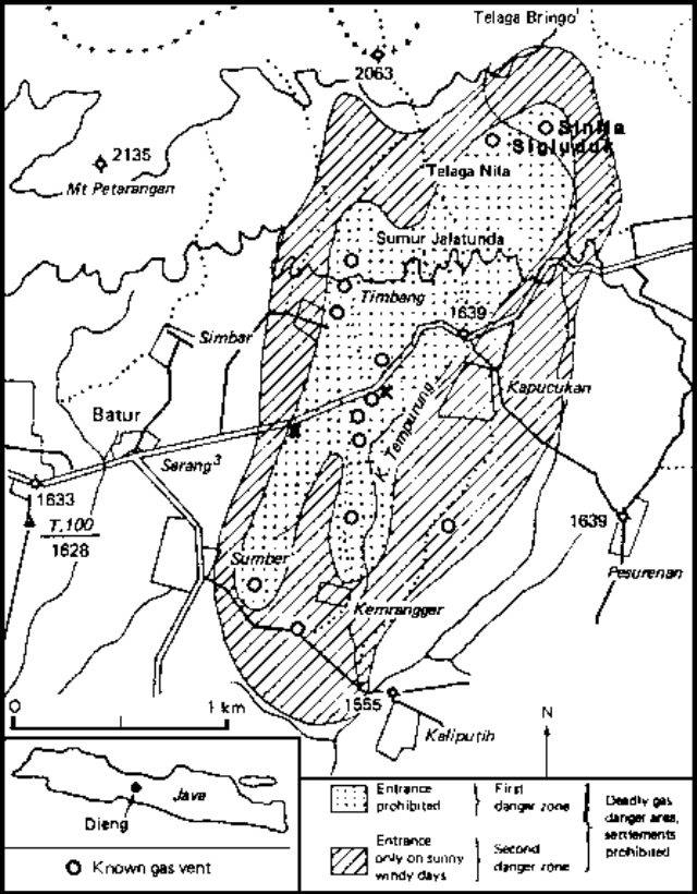 |
Figure 1. Hazard zonation map showing the SW portion of the Dieng Volcanic Complex. Entry is prohibited to the first danger zone (dotted pattern); entry is permitted to the second danger zone (diagonal lines) only on sunny, windy days. Known gas vents are represented by circles; fatalities are marked by x's. Courtesy of Adjat Sudradjat, VSI. |
Residents of Koputjukan village fled the activity in several directions. Many of those who headed W towards Batur were killed by gas containing CO2 and H2S, emitted from many small vents and fissures S and W of the two craters, ponded in a low-lying area beside the road. Others were killed near an elementary school, to which they had retreated after observing the deaths along the Koputjukan-Batur road. Both areas had been known to emit poisonous gases in the past. Four rescue workers were also killed. About 15,000 were evacuated from six nearby villages, and two danger zones were delineated around the gas vents (figure 1); entry into the inner zone was completely prohibited, and use of the outer zone was limited to daylight hours.
Activity from the two explosion craters declined after ejection of a dark gray cloud from Sigluduk at 1100 on 20 February. By dawn the next day, Sinila was emitting dense white vapor, but only a little white vapor was escaping from Sigluduk. VSI personnel visited the craters early on the 22nd. Sinila's vapor emission had ended, although the bottom of the crater, 60-70 m across and 40 m deep, was filled with bubbling mud. Sigluduk, 25 m in diameter and 10 m deep, contained an active solfatara with a temperature of 71°C.
Further Reference. Le Guern, F., Tazieff, H., and Faivre Pierret, R., 1982, An example of health hazard: people killed by gas during a phreatic eruption: Dieng Plateau, Java, Indonesia: BV, v. 45, p. 153-156.
Information Contacts: S. Modjo, VSI; M. Krafft, Cernay; Kompas and Sinar Harapan, Jakarta.
Earthquake swarm, but little change in thermal activity
On 17 November an area of the Dieng volcanic complex with a history of poisonous gas emission experienced an MM 2-3 felt earthquake. A tripartite electromagnetic seismometer located the shocks in a zone of fractures and gas emission 1-2 km E of Batur. Newspapers and radio broadcasts reported that 3-12 seismic events were recorded during each of the 10 days ending 6 December. However, the number of events began to decrease in early December, and seismicity was continuing to decline as of the 17th.
There were no indications of volcanic activity. The poisonous gas content of vapor sampled at several known emission sites had not changed more than 15% from previous measurements. The temperature of the pool of boiling mud at Sileri cone and the thermal feature Sikidang, a few kilometers E of the zone, remained unchanged at 90°C. Government officials issued an alert, but removed it after receiving a VSI report.
Information Contacts: A. Sudradjat, VSI; Jakarta DRS.
Earthquakes and tremor but no change in thermal activity
"A widely-felt earthquake occurred near Dieng on 13 April at 0747. Tremor was recorded for up to 10 minutes 14-15 April. Additional small earthquakes were recorded in the following two weeks. No changes were noted in thermal activity."
Information Contacts: Olas, Suratman, Suparto, Kaswanda, and A. Sudradjat, VSI.
Phreatic explosions on August 6
[Phreatic eruptions took place on 6 August 1986 from the Sileri crater lake. The height of mud ejection was not observed, but the crater was covered by thick white smoke that rose ~300 m high. After a few hours the spout was ~6-7 m high and was gradually decreasing.]
Information Contacts: S. Siswowidjoyo and W. Modjo, VSI (as reported in BVE, no. 26, March 1989).
Sudden gas emission kills one person and hospitalizes two others
A sudden gas emission occurred at about 1600 on 18 March from a fractured and altered zone in a river valley 200 m W of Sikidang Crater. After the gas emission, one person was found dead in the stream, and two others were hospitalized after trying to rescue him. Surface gas measurements the next day indicated high concentrations of CO2 and O2 (40 and 15 weight %, respectively), and lesser concentrations of H2S and HCN (200 and 197 ppm, respectively).
Steam emission continued from Sileri Crater (~3 km NNW of Sikidang), rising 40-60 m in mid-April. An average of one A-type and seven B-type volcanic earthquakes were recorded daily during mid-April, an increase from earlier in the month.
Information Contacts: W. Modjo, VSI; T. Casadevall, USGS.
Hot mud fountains and steam emissions; poisonous gas
Hot mud began fountaining from a new vent (near the Pandawa Lima Temples) area at 0001 on 23 January. The fountaining was heard by residents of a nearby village (Bale Kambang). The hot mud, which emerged from a 5-m-diameter hole, had a temperature of 93°C and reached heights of 2-15 m. Hot mud and steam emissions were continuing on 8 February, with fountaining to 1 m height. The area within 25 m of the hole has been covered with mud. Gas measurements taken on 8 February detected 15 ppm HCN and 12 ppm H2S. Shallow volcanic earthquakes were recorded in January at rates of 3-20/day, but were decreasing prior to the 23 January activity. Seismicity has continued since then.
Information Contacts: W. Tjetjep, VSI.
Plumes and earthquakes in early July
Seismicity increased in late June and early July. Earthquakes of M ~2 were felt locally three times on 2 July, and once on 4 July. An emission plume of white, moderately thick steam without ash issued from Sileri crater under low pressure to a height of 50 m. There was a moderate smell of sulfur. The crater lake water was clear to gray in color with temperatures varying between 54 and 94°C.
Information Contacts: R. Sukhyar, Director, Volcanological Survey of Indonesia (VSI), Bandung, Indonesia (URL: http://www.vsi.esdm.go.id/).
Increase in seismicity and plume emission beginning in April 2002
The last reported activity at Dieng occurred during late June and early July 1998, when three M ~2 earthquakes were felt and a white steam plume was emitted from Sileri crater to a height of 50 m (BGVN 23:08). During April 2002, the Volcanological Survey of Indonesia (VSI) reported that activity at Dieng increased. Beginning on 19 April the number of deep and shallow volcanic earthquakes increased (table 1), and a white plume of variable thickness rose 25-50 m above Sileri crater. The temperatures of fumaroles in various craters were 50-95°C (table 2). Dieng remained at Alert Level 2 through at least 26 May 2002.
Table 1. Earthquakes recorded at Dieng during 15 April through 19 May 2002. Courtesy VSI.
| Date | Deep volcanic (A-type) | Shallow volcanic (B-type) | Far Tectonic | Local Tectonic |
| 15 Apr-21 Apr 2002 | 14 | 10 | 1 | 0 |
| 22 Apr-28 Apr 2002 | 75 | 121 | 1 | 1 |
| 29 Apr-05 May 2002 | 18 | 64 | 0 | 0 |
| 06 May-12 May 2002 | 6 | 82 | 0 | 0 |
| 13 May-19 May 2002 | 2 | 24 | 1 | 0 |
Table 2. Temperatures of various craters of Dieng during 15 April through 12 May 2002. "--" indicates that the information was not reported. Courtesy VSI.
| Date | Sikidang | Sibateng | Sileri | Condrodimuko | Sinila | Siglagah | Bitingan | Pagerkandang |
| 15 Apr-21 Apr 2002 | 90-94°C | 91-94°C | 68°C | 90-93°C | 70-74°C | 90-94°C | -- | -- |
| 22 Apr-28 Apr 2002 | 91-95°C | 92-94°C | 69°C | -- | 76-75°C | -- | 50-57°C | 90-94°C |
| 29 Apr-05 May 2002 | -- | -- | -- | 90-93°C | 74-75°C | -- | -- | -- |
| 06 May-12 May 2002 | -- | -- | 69°C | -- | -- | -- | 50-56°C | -- |
Information Contacts: Dali Ahmad, Volcanological Survey of Indonesia (VSI), Jalan Diponegoro No. 57, Bandung 40122, Indonesia (URL: http://www.vsi.esdm.go.id/).
Plume emissions and modest seismicity through early July 2002
Seismicity and plume frequency increased at Dieng beginning in April 2002 (BGVN 27:05). During 27 May-7 July 2002, the Volcanological Survey of Indonesia (VSI) reported higher-than-normal activity. Deep and shallow earthquakes were recorded, along with tectonic events (table 3). During 27 May-9 June, VSI reported a white plume from Sileri crater up to 50 m high. Observations in mid-June revealed a mud ejection from Sikidang crater. Dieng remained at Alert Level 2 (on a scale of 1-4). No further reports were issued through at least May 2003.
Table 3. Earthquakes recorded at Dieng during 27 May-7 July 2002. Courtesy VSI.
| Date | Deep volcanic | Shallow volcanic | Distant tectonic |
| 27 May-02 Jun 2002 | 1 | 25 | 1 |
| 03 Jun-09 Jun 2002 | 1 | 38 | 1 |
| 10 Jun-16 Jun 2002 | 13 | 14 | 1 |
| 17 Jun-23 Jun 2002 | -- | 18 | 3 |
| 24 Jun-30 Jun 2002 | -- | 7 | 2 |
| 01 Jul-07 Jul 2002 | -- | 3 | -- |
Information Contacts: Dali Ahmad, Volcanological Survey of Indonesia (VSI), Jalan Diponegoro No. 57, Bandung 40122, Indonesia (URL: http://www.vsi.esdm.go.id/).
Mud bubbling and outflows at Sileri crater that reached 50 m beyond crater rim
According to the Volcanological Survey of Indonesia (VSI), on 20 July 2003 mud poured from Sileri crater. The crater contains a lake and boiling mud pots, and has been the site of small-to-moderate historical eruptions. The incident of 20 July occurred at night and sent mud as far as 25 m S of the crater rim. On 21 July, a temperature measurement of the crater recorded 74°C, no striking increase from earlier measurements.
On the morning of 24 July, another mud outpouring from the crater covered an area up to 50 m N and E of the crater rim. Activity then continued with small areas of mud bubbling and ejecta thrown 1 m high at the middle of the crater. Neither of the mud-outpouring events were recorded on the seismometer 1.1 km S of the crater. The volcano's hazard status was raised to level 2 on 22 July.
Information Contacts: Dali Ahmad, Volcanological Survey of Indonesia (VSI), Jalan Diponegoro No. 57, Bandung 40122, Indonesia (URL: http://www.vsi.esdm.go.id/).
One shallow volcanic earthquake and a gas plume in early August
The Volcanological Survey of Indonesia (VSI) activity report for the week of 4-10 August 2003 noted, for the Sileri crater in the Dieng volcano complex, one shallow volcanic earthquake, a white gas plume rising 25-60 m, and water temperature of 83°C. The hazard status was set at Alert Level 2 (on a scale of 1-4).
Information Contacts: Dali Ahmad and Nia Haerani, Volcanological Survey of Indonesia (VSI), Jalan Diponegoro No. 57, Bandung 40122, Indonesia (URL: http://www.vsi.esdm.go.id/).
Landslide triggers sudden, small, phreatic eruption on 15 January 2009
This report discusses a small phreatic eruption at Dieng from Sibanteng crater in January 2009. The Dieng complex covers more than 80 km2 in Central Java NW of Yogyakarta. The volcanic field trends E and contains two or more stratovolcanoes, more than 20 craters and cones, several crater lakes, a caldera, and active thermal features (van Bergen and others, 2000). Phreatic eruptions are those that eject both magmatic gasses and steam, and contain fragments of pre-existing solid rock from the volcanic conduit or vent, but without primary erupted magma. Many of these eruptions are attributed to subsurface interaction between magma and groundwater (Germanovich and Lowell, 1995). Some are precursors to phreatomagmatic and magmatic eruptions.
Recent reports discussed mud ejected from the active Sileri crater in July 2003 associated with a modest increase in seismicity and steam plumes during April-July 2002 and August 2003 (BGVN 27:05, 28:06, 28:07, and 28:09). A May 2005 pilot report of a steam plume turned out to be caused by pipe maintenance at Dieng's geothermal site.
January 2009 landslide and eruption. This event began when, after three days of heavy rain, one or more landslides broke loose in steep volcanic terrain at about the 1900- to 2000-m elevation at 0800 on 15 January 2009. Landslide debris covered the floor of Sibanteng crater, sealing the vent there. At 0830 a sudden and short-lived phreatic eruption took place. The alert level was raised to 2 (on a scale of 1 to 4).
Much of these and other details were learned by an emergency response team from the Center of Volcanology and Geological Hazard Mitigation (CVGHM), who conducted a field investigation between 16-21 January. The team's findings are discussed below (as extracted from the CVGHM report dated 22 January 2009 ("Tanggap Darurat G. Dieng Kab. Wonosobo, Prov. Jawa Tengah, tanggal 16-21 Januari 2009").
The eruption left an explosion crater about 50 m in diameter and deposited the bulk of the erupted material in a ~ 50 m radius. The erupted deposits consisted of material from the landslide and vent area. This relationship indicated that the landslide preceded the phreatic eruption. The landslides covered an area 100 x 200 m, with an estimated 40,000 m3 of debris. In places, the landslide debris created temporary dams. One blocked the Kali Putih River, and downstream, the Kali Tulis River.
On 17 January, four additional seismic stations were installed. Three were in the vicinity of the Sibanteng and Sikidang craters and one was near the thermally active colored lake Telaga Warna. Earthquakes and tremor were both absent on the seismographic record at Timbang crater during 17-20 January following the phreatic eruption.
The team reported that witnesses in the field had heard two explosions. The first came from the landslide; the second, the phreatic eruption. During their visit, the eruption vent emitted a white plume 5 m high. The vent was largely covered by landslide debris from Sibanteng crater's upper wall. In Sibanteng and other craters temperature ranges were 93.2-93.6° C, values similar to previous data.
The concentrations of gases, including hydrogen sulfide (H2S), sulfur dioxide (SO2), methane (CH4), carbon dioxide (CO2), and carbon monoxide (CO) were reported for eight locations. The CO and CO2 concentrations were below ~ 1 ppm. H2S concentrations were under ~ 7 ppm, with the highest value seen near a thermal feature at Skikdang, but a 6 ppm value near a bulletin board in a tourist area. The eight SO2 concentrations were under 18 ppm. CH4 concentrations ranged between 5 and 17 ppm. (More detailed data are available in the 22 January CVGHM report.)
The investigation indicated that the phreatic eruption was preceded by one or more landslides that covered the floor of Sibanteng crater. The team suggested that the sealing action and pressure buildup due to the landslide caused the phreatic eruption. They concluded that the phreatic eruption posed no danger to the public because the Sibanteng crater is not close to an inhabited area. However, they noted that landslide debris was still unstable and could be easily dislodged and transported by rainwater.
Reference. Germanovich, L.N., and Lowell, R.P., 1995, The mechanism of phreatic eruptions: J. Geophys. Res., v. 100 (B5), p. 8417-8434.
van Bergen, M.J., Bernard, A., Sumarti, S., Sriwana, T., and Sitorus, K., 2000, Crater lakes of Java: Dieng, Kelud and Ijen, Excursion Guidebook, IAVCEI General Assembly, Bali 2000 (URL: www.ulb.ac.be/sciences/cvl/DKIPART1.pdf).
Information Contacts: Center of Volcanology and Geological Hazard Mitigation (CVGHM), Jalan Diponegoro 57, Bandung 40122, Indonesia (URL: http://vsi.esdm.go.id/).
Seismicity before a 26 September 2009 phreatic eruption
This report describes a phreatic eruption at Dieng on 26 September, an event preceded by increased seismicity. Previously, a phreatic eruption on 15 January 2009 followed the burial and sealing of the floor of the Sibanteng crater by landslides (BGVN 34:04). In the past, a large number of eruptions from the Dieng complex have been minor phreatic events (Germanovich and Lowell, 1995; van Bergen and others, 2000). Monitoring is carried out by the Center for Volcanology and Mitigation of Geologic Disasters (CVGHM) from the village of Karang Tengah.
Seismic activity within the complex began in early September 2009. Four deep volcanic and two shallow volcanic earthquakes preceded a phreatic eruption on 26 September. On that day CVGHM reported a thunderous noise from Dieng heard up to 2 km away. The next day, a phreatic eruption from an unspecified crater ejected mud as far away as 140 m S. The deposits were as thick as 10 cm near the vent and 1 cm near the farthest point of deposition. Scientists did not observe an increase in the concentration of poisonous gases at either the vent or in the surrounding area.
Reference. Germanovich, L.N., and Lowell, R.P., 1995, The mechanism of phreatic eruptions: J. Geophys. Res., v. 100 (B5), p. 8417-8434.
van Bergen, M.J., Bernard, A., Sumarti, S., Sriwana, T., and Sitorus, K., 2000, Crater lakes of Java: Dieng, Kelud and Ijen, Excursion Guidebook, IAVCEI General Assembly, Bali 2000 (URL: www.ulb.ac.be/sciences/cvl/DKIPART1.pdf).
Information Contacts: Center of Volcanology and Geological Hazard Mitigation (CVGHM), Jalan Diponegoro 57, Bandung 40122, Indonesia (URL: http://vsi.esdm.go.id/).
Seismicity and dangerous gas emissions; 1,200 evacuate in May-June 2011
This report on Dieng volcanic complex (figure 2) notes both toxic gas emissions and episodes of high seismicity during 1 October 2009-July 2011. A late May 2011 visit, after increased gas emissions were noted the previous week, revealed dead birds and damaged vegetation at Timbang crater. Gas measurements at several sites confirmed the presence of hazardous gases; however, there were no human fatalities or injuries noted. According to news reports, 1,200 people were evacuated. Our previous report on Dieng discussed a phreatic eruption on 26 September 2009, preceded by a series of volcanic earthquakes (BGVN 34:08).
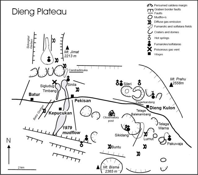 |
Figure 2. A sketch map for Dieng Volcanic Complex, which lies in Central Java associated with the ~2-km-high plateau of the same name. The Dieng plateau is E-trending and roughly 14 by 6 km. Taken from Van Bergen and others (2000). |
During January 2010, landslides took place near Dieng, followed by others at distance. One landslide crossed the highway between Dieng and Wonosobo (the regional capital, 18 km S of Dieng). The second landslide struck a village called Wonoaji, and according to a Jakarta Post article (by Suherdjoko, 21 January 2010), "Two people [there] have died and three are still missing, while five others were injured. . . ."
Although little was reported regarding Dieng during October 2009-2010, Relief Web posted a graphic describing heavy rains and regional flooding during February 2010 in the portion of Central Java hundreds of kilometers E of Dieng near Bandung. This episode triggered a landslide in Ciwidey village taking 17 lives.
The latest reported activity at Dieng began in mid-2011. According to the Center of Volcanology and Geological Hazard Mitigation (CVGHM), seismicity at Dieng increased during 18-22 May 2011. On 22 May, diffuse white plumes rose from the Timbang cone; plumes from the cone had not been previously observed. The next day carbon dioxide (CO2) emissions increased. On 23 May, CVGHM raised the Alert Level to 2 (on a scale of 1-4).
CVGHM reported that on 29 May 2011, gas plumes rose 50 m above Timbang cone. The gas plumes drifted S through the valley. Observers who visited the cone noted the previously mentioned damaged vegetation and dead birds. Seismicity and CO2 emissions remained elevated, thus prompting CVGHM to raise the Alert Level to 3.
During 4-5 June white plumes from Sileri crater rose 20-60 m and white plumes from Timbang rose only 2 m and drifted 300 m S. Seismicity and carbon dioxide remained high through 5 June
According to CVGHM, carbon-dioxide emissions from Timbang declined during 31 May-10 June, while seismicity decreased during 5-7 June and was not detected during 8-10 June. White plumes were not observed. On 10 June the Alert Level was lowered to 2.
Stated gas concentrations. In early June, low levels of hydrogen sulfide (H2S, 0.002-0.05% by volume) were recorded at Sikendang, Sikidang, Sibanteng, and Sileri craters. Carbon monoxide gas (CO) was only detected along the steam vents of Sikendang crater, at a concentration of 0.004% by volume. CO2 was measured at a concentration of 5.0% by volume. On 5 June, the CO2 from Timbang was at its highest level at, 1.54% by volume. The scientists added that weather patterns had brought low atmospheric pressure, which had enhanced gas escape at the vent.
John Seach presents modest-resolution photos from 2010 showing the Sikidang vent mentioned above, and Telega Warna crater lake (see Information Contacts).
Figure 3 shows one approach to communicating gas-hazards warnings.
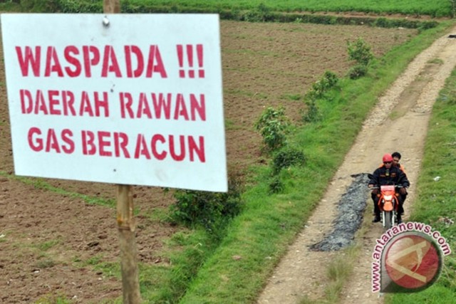 |
Figure 3. A sign written in Indonesian warning people crossing a part of the Dieng complex susceptible to dangerous gas emissions. The sign states, "Caution—Contaminated Area—Poisonous Gases." This photo appeared in an article published 5 June 2011 in the news source ANTARA/Anis Efizudin. |
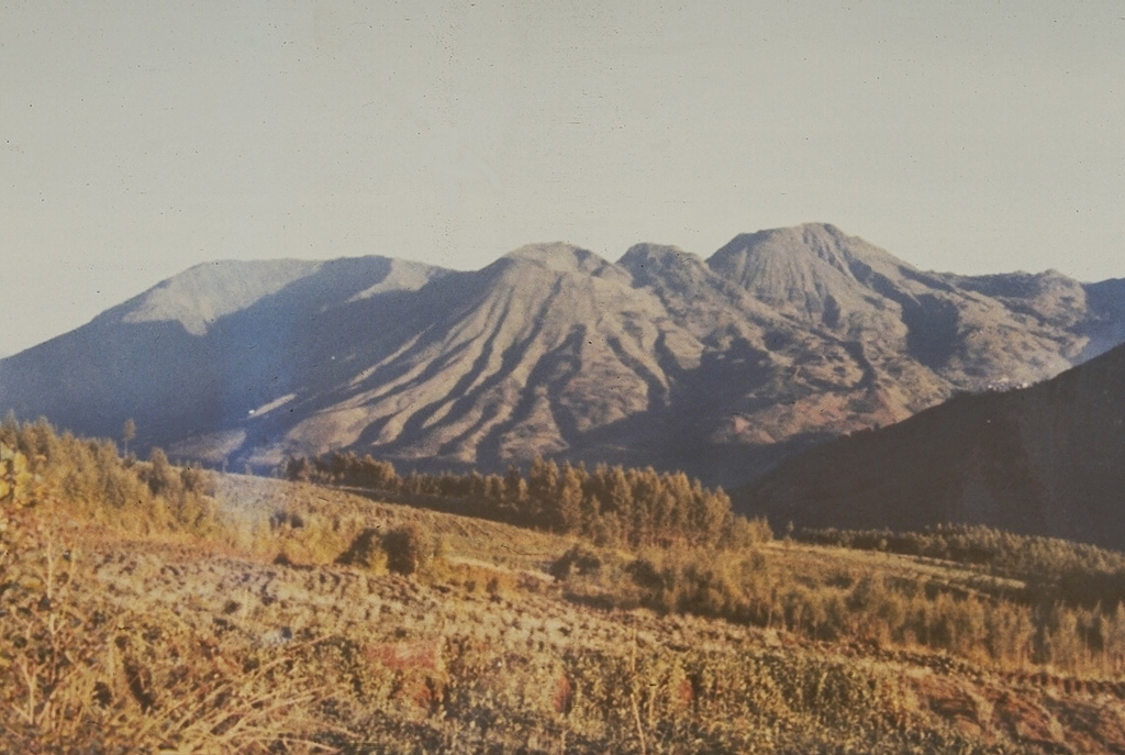
Dieng plateau. In the modern record, Dieng has a history of lethal gas emissions, phreatic explosions, and other hazards. The complex contains rocks ranging from andesite to rhyodacite, extrusives filling and sitting upon a large older (Pleistocene) caldera. It contains several stratovolcanoes, and many cones, craters, domes, and thermal features (see subsections below).
Van Bergen and others (2000) described the plateau and associated volcanic complex, portions of which follow.
"The Dieng Volcanic Complex in Central Java is situated on a highland plateau at about 2000 m above sea level, approximately 25 km N of the city of Wonosobo. It belongs to a series of Quaternary volcanoes, which includes the historically active Sumbing and Sundoro volcanoes. The plateau is a rich agricultural area for potatoes, cabbages, tomatoes and other vegetables. There are numerous surface manifestations of hydrothermal activity, including lakes, fumaroles/solfatara and hotsprings. The area is also known for the development of geothermal resources and lethal outbursts of gas. Scattered temples are the witnesses of the ancient Hindu culture that once reigned.
"In terms of chemical composition, Telaga Warna is the most interesting crater lake in the Dieng area. The original shape of the crater has been modified by a lava flow. The water occupies less than 1 km2. Gas bubbles can be seen rising to the lake surface, and the air has a sulfurous odor. Its colorful appearance (warna stands for color(s) in Indonesian) makes the lake an interesting tourist attraction. The water has a pH of about 3, which may fluctuate depending on seasonal variations. Sulfate and chloride contents are moderately high. . . . Strong emissions of CO2-rich gas on-shore have occasionally killed animals, so that a path on the N side used to be closed to avoid risks for local villagers."
The same report presents some composition data from 1994. Some of the 'dry' gas from several vents in the complex were up to 90% CO2.
Geothermal energy. According to Geo Dip Energi, the Dieng #1 project is currently in operation and producing 60 MegaWatts (MW) of energy. Two more projects, each of 60 MW are underway. The Dieng area is thought to have more potential and could produce 300 MW.
Reference. Van Bergen, M., Bernard, A., Sumarti, S., Sriwana, T., and Sitorus, K., 2000. Crater Lakes of Java: Dieng, Kelud, and Ijen. Excursion Guidebook, IAVCEI General Assembly, Bali 2000, 9 pp. URL: http://www.ulb.ac.be/sciences/cvl/DKIPART1.pdf).
Information Contacts: Center of Volcanology and Geological Hazard Mitigation (CVGHM), Jalan Diponegoro 57, Bandung 40122, Indonesia (URL: http://vsi.esdm.go.id/); Geo Dipa Energi, Recapital Building 8th Floor, Jl. Aditiawarman Kav. 55 Jakarta Selatan 12160 Indonesia (URL: http://www.geodipa.co.id); John Seach, Volcano Live (URL: http://volcanolive.com); Xinhua News (URL: http://www.xinhuanet.com/english2010/); Jakarta Globe (URL: http://www.thejakartaglobe.com/home/).
Alert Level raised due to gas emissions; moderate earthquake felt
The Center of Volcanology and Geological Hazard Mitigation (CVGHM) reported that during 7-11 March 2013 instruments monitoring the Dieng Volcanic Complex detected carbon dioxide (CO2) plumes from Timbang Crater, a cone that is part of the Dieng Volcanic Complex (see figure 2 in BGVN 36:06), drifting 50-200 m S. A strong sulfur odor was also reported, along with dead animals near the crater on 7 March. Observers noted white plumes rising from the crater that were diffuse during 7-8 March and dense during 9-10 March; the concentration increased during 9-10 March 2013. Because of the increase of CO2 emissions, CVGHM raised the Alert Status, which spans a scale of 1 to 4, from 1 (aktif - normal) to 2 (waspada - alert) on 13 March, and warned the public not to approach Timbang Crater within a 500 m radius. The last eruption reported from Dieng was 27 September 2009 at Sileri crater (BGVN 34:08; see figure 2 in BGVN 36:06). Table 4 shows the most recent Alert Levels for Dieng.
Table 4. Most recent Alert Levels reported for Dieng. Courtesy of CVGHM.
| Date of Level change | Alert Level |
| 01 Sep 2011 | 1 |
| 11 Mar 2013 | 2 |
| 27 Mar 2013 | 3 |
| 08 May 2013 | 2 |
During 10-26 March 2013 gas emissions continued to be elevated at Timbang crater. Plumes containing CO2 and hydrogen sulfide (H2S) drifted 2 km, and were at toxic levels at a distance of 550 m. Seismicity increased during 13-26 March 2013 and then significantly increased on 27 March. CVGHM raised the Alert Level to 3 (siaga - standby) on 27 March 2013 and warned the public not to approach Timbang Crater within a 1 km radius.
On 28 March 2013 gas emissions continued to raise at Timbang. Plumes containing carbon dioxide (CO2) drifted 2 km towards the S valley of Kali Sat, prompting a road closure until the early evening when the gas concentration decreased. On 30 March 2013 CO2 gas emissions were not detected; however, 'smoke' rose at most 100 m above the crater, and hydrogen sulfide (H2S) odors were very potent in areas 1 km W and weak in areas 1.5 km S.
On 24 March 2013 Sileri Crater lake water changed from dark gray to brown, and on 7 April white plumes rose 50 m and the water color returned to normal. Diffuse white plumes rose 15 m on 20 April. Other craters had not exhibited any changes by 28 April 2013.
On 19 April sulfur dioxide (SO2) odors were reported. According to CVGHM, an M 4.8 earthquake occurred ~14 km SSW of Dieng and ~8 km NNW of Wonosobo at 1900 local time on 19 April 2013. It had a hypocentral depth of 10 km, was of a tectonic nature, but with possible influence on Dieng volcano. Eighty-six weaker quakes followed the main shock within 25 minutes. No buildings collapsed due to the earthquake, but at least 311 houses were damaged, 34 of them severely and 27 of them moderately. Two people were injured. As a precaution associated with a potential eruption, approximately 1,000 people were evacuated; they were returning to their villages by 21 April due to a decrease in volcanic activity of the Dieng volcano complex.
Based on gas concentrations, seismicity, and visual observations, CVGHM lowered the Alert Level to 2 on 8 May 2013.
Residents living in the vicinity of Dieng (close to Mt. Sundoro and Mt. Sumbing) on Java (see figure 1 in BGVN 33:11), were the subject of a study of people's perceptions and reactions to volcanic hazards (Lavigne and others, 2008).
Reference: Lavigne, F., De Coster, B., Juvin, N., Flohic, F., Gaillard, J-C., Texier, P., Morin, J., and Sartohadi, J., 2008, People's behaviour in the face of volcanic hazards: Perspectives from Javanese communities, Indonesia, Journal of Volcanology and Geothermal Research, v.172, issue 3-4, p. 273-287.
Information Contacts: Center of Volcanology and Geological Hazard Mitigation (CVGHM) (Pusat Vulkanologi dan Mitigasi Bencana Geologi (PVMBG)), Jalan Diponegoro 57, Bandung 40122, Indonesia (URL: http://vsi.esdm.go.id/).
Three phreatic eruptions at Sileri Crater; deaths due to helicopter crash involved in evacuations
Located on an elevated plateau in central Java NW of Yogyakarta (figure 4), multiple craters within the Dieng Volcanic Complex (figure 5) have been intermittently active over the past 200 years. Brief phreatic eruptions took place at Sibanteng crater on 15 January 2009 (BGVN 34:04) and at Sileri crater on 26 September later that year (BGVN 34:08). Increased unrest during March-April 2013 (BGVN 38:08) consisted of elevated volcanic gas emissions from Timbang Crater that resulted in an increase in the Alert Level to as high as 3 on 27 March, then back to Level 2 on 8 May. There was a precautionary evacuation of local villages, but no eruption took place. Regular monitoring is done by the Pusat Vulkanologi dan Mitigasi Bencana Geologi (PVMBG, also known as Centre for Volcanology and Geological Hazard Mitigation or CVGHM).
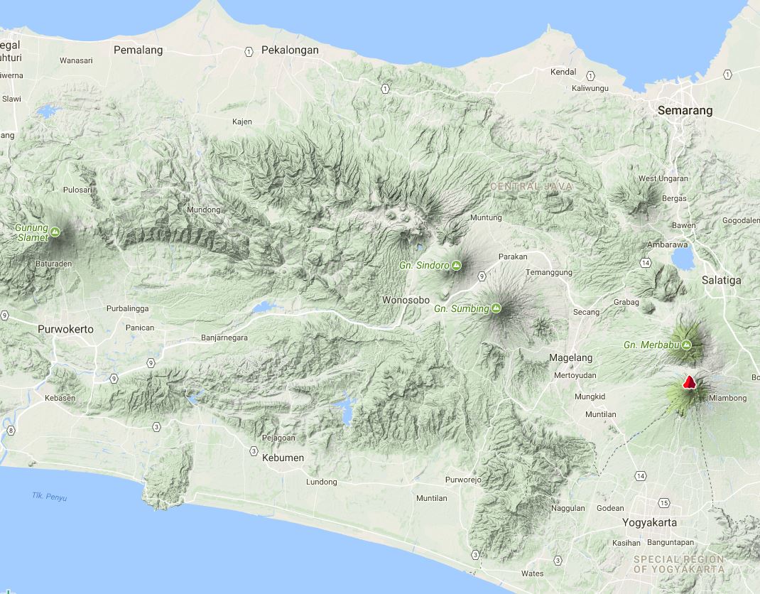 |
Figure 4. Topographic terrain map of central Java showing the Dieng Volcanic Province to the NW of Gunung Sumbing and Gunung Sindoro volcanoes. The volcano indicated by a red symbol N of Yogyakarta is Merapi. Courtesy of Peakery. |
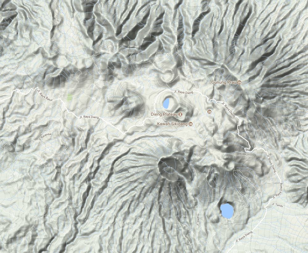 |
Figure 5. Topographic terrain map of the Dieng Volcanic Province on the Dieng plateau of central Java. The notable cone at bottom center is Bisma; the crater with a lake at center is Merdada, adjoining Kawah Sikidang to the SE. The frequently active Sileri area is immediately W of the more noticeable Pagerkandang crater N of Merdada. Courtesy of Peakery. |
The alert status remained at Level 2 for about 15 months following the hazardous gas emissions in 2013. On 11 August 2014 the PVMBG noted that, due to decreased activity and no observable flow of gas in high concentrations from the crater, the Alert Level was lowered to 1 (on a scale of 1-4). No further activity was reported until late April 2017.
A phreatic event from Sileri Crater at 1303 on 30 April 2017 ejected material 10 m high and 1 m past the crater edge, forming a 1-2 mm thick deposit. Another emission at 0941 on 24 May consisted of gas and black "smoke" that rose 20 m.
The Disaster Management Authority, Badan Nacional Penanggulangan Bencana (BNPB), reported that there had been another phreatic eruption from the Sileri Crater lake at 1154 on 2 July 2017, ejecting mud and material 150 m high, and 50 m to the N and S. The event injured 11 of 18 tourists that were near the crater. According to a news article a helicopter on the way to assist with evacuations after the event crashed, killing all eight people (four crewmen and four rescuers) on board. PVMBG scientists visited the next day and observed weak white emissions rising 60 m.
PVMBG reported that during 8 July-14 September 2017 measurements indicated an increase in water temperature at Sileri Crater lake from 90.7 to 93.5°C. Soil temperatures also increased, from 58.6 to 69.4°C. At Timbang Crater temperatures in the lake increased from 57.3 to 62.7°C, and in the soil they decreased from 18.6 to 17.2°C. The report noted that conditions at Timbang Crater were normal.
Temperature increases at Sileri, along with tremor detected during 13-14 September, prompted PVMBG to raise the Alert Level to 2 (on a scale of 1-4). PVMBG warned the public to stay at least 1 km away from the crater rim, and for residents living within that radius to evacuate. However, after 20 September tremor and water temperatures both declined. The Alert Level was lowered back to 1 on 2 October, with a warning to stay at least 100 m from the crater rim.
Information Contacts: Pusat Vulkanologi dan Mitigasi Bencana Geologi (PVMBG, also known as Indonesian Center for Volcanology and Geological Hazard Mitigation, CVGHM), Jalan Diponegoro 57, Bandung 40122, Indonesia (URL: http://www.vsi.esdm.go.id/); Badan Nasional Penanggulangan Bencana (BNPB), National Disaster Management Agency, Graha BNPB - Jl. Scout Kav.38, East Jakarta 13120, Indonesia (URL: http://www.bnpb.go.id/); Peakery (URL: https://peakery.com/).
Phreatic explosion on 1 April 2018 at Sileri Crater
Dieng has had a history of intermittent phreatic explosions. In 2017, explosions occurred on 30 April, 24 May, and 2 July (BGVN 42:10). Another phreatic explosion occurred on 1 April 2018. The volcano is monitored by the Pusat Vulkanologi dan Mitigasi Bencana Geologi (PVMBG, also known as Centre for Volcanology and Geological Hazard Mitigation or CVGHM).
PVMBG reported that a phreatic explosion at the Sileri Crater lake (Dieng Volcanic Complex) occurred at 1342 on 1 April 2018, ejecting mud and material 150 m high, and up to 200 m in multiple directions. The event was preceded by black emissions that rose 90 m, and then diffuse white emissions that rose 150 m. The report noted that few tourists were in the area due to rainy weather; visitors are not permitted within 200 m of the crater rim.
According to a news report (The Jakarta Post) that cited an official of the National Disaster Management Agency (BNPB), no toxic gases such as carbon dioxide, hydrogen sulfide, or sulfur dioxide were detected in the explosion.
Information Contacts: Pusat Vulkanologi dan Mitigasi Bencana Geologi (PVMBG, also known as Indonesian Center for Volcanology and Geological Hazard Mitigation, CVGHM), Jalan Diponegoro 57, Bandung 40122, Indonesia (URL: http://www.vsi.esdm.go.id/); Badan Nasional Penanggulangan Bencana (BNPB), National Disaster Management Agency, Graha BNPB - Jl. Scout Kav.38, East Jakarta 13120, Indonesia (URL: http://www.bnpb.go.id/); The Jakara Post (URL: http://www.thejakartapost.com).
Phreatic explosion on 29 April 2021
Infrequent phreatic explosions have occurred at the Sileri Crater Lake in the Dieng Volcanic Complex, with three explosions between 30 April and 2 July 2017, and one on 1 April 2018 (BGVN 42:10, 43:05). None were reported in 2019 and 2020. The volcano is monitored by the Pusat Vulkanologi dan Mitigasi Bencana Geologi (PVMBG, also known as Centre for Volcanology and Geological Hazard Mitigation or CVGHM).
PVMBG reported that a phreatic explosion at the Sileri Crater Lake occurred at 1825 on 29 April 2021, ejecting rocks 200 m S and E and mud 400 m S and 300 m E. According to a news article, a local road was temporarily closed because rocks (about 10 cm in diameter) from the explosion were scattered along the road and the mud made conditions slippery. The closest residents are 1 km away. The Alert Level remained at 1 (on a scale of 1-4), and the public was warned to stay 500 m away from the crater rim.
Information Contacts: Pusat Vulkanologi dan Mitigasi Bencana Geologi (PVMBG, also known as Indonesian Center for Volcanology and Geological Hazard Mitigation, CVGHM), Jalan Diponegoro 57, Bandung 40122, Indonesia (URL: http://www.vsi.esdm.go.id/); Detik News (URL: https://news.detik.com/).
|
|
||||||||||||||||||||||||||
There is data available for 30 confirmed eruptive periods.
2024 Dec 18 - 2025 Jan 6 Confirmed Eruption (Phreatic) VEI: 1
| Episode 1 | Eruption (Phreatic) | Sileri Crater Lake | |||||||||||||||||||||||
|---|---|---|---|---|---|---|---|---|---|---|---|---|---|---|---|---|---|---|---|---|---|---|---|---|
| 2024 Dec 18 - 2025 Jan 6 | Evidence from Observations: Reported | |||||||||||||||||||||||
|
List of 3 Events for Episode 1 at Sileri Crater Lake
|
||||||||||||||||||||||||
2021 Apr 29 - 2021 Apr 29 Confirmed Eruption (Explosive / Effusive) VEI: 1
| Episode 1 | Eruption (Explosive / Effusive) | ||||||||||||||||||||||||
|---|---|---|---|---|---|---|---|---|---|---|---|---|---|---|---|---|---|---|---|---|---|---|---|---|
| 2021 Apr 29 - 2021 Apr 29 | Evidence from Observations: Reported | |||||||||||||||||||||||
|
List of 3 Events for Episode 1
|
||||||||||||||||||||||||
2018 Apr 1 - 2018 Apr 1 Confirmed Eruption (Explosive / Effusive) VEI: 1
| Episode 1 | Eruption (Explosive / Effusive) | Sileri Crater | ||||||||||||||||||||||||||||
|---|---|---|---|---|---|---|---|---|---|---|---|---|---|---|---|---|---|---|---|---|---|---|---|---|---|---|---|---|---|
| 2018 Apr 1 - 2018 Apr 1 | Evidence from Observations: Reported | ||||||||||||||||||||||||||||
|
List of 4 Events for Episode 1 at Sileri Crater
|
|||||||||||||||||||||||||||||
2017 Apr 30 - 2017 Jul 2 Confirmed Eruption (Phreatic) VEI: 1
| Episode 1 | Eruption (Phreatic) | Sileri Crater | |||||||||||||||||||||||||||||||||||||||||||
|---|---|---|---|---|---|---|---|---|---|---|---|---|---|---|---|---|---|---|---|---|---|---|---|---|---|---|---|---|---|---|---|---|---|---|---|---|---|---|---|---|---|---|---|---|
| 2017 Apr 30 - 2017 Jul 2 | Evidence from Observations: Reported | |||||||||||||||||||||||||||||||||||||||||||
|
List of 7 Events for Episode 1 at Sileri Crater
|
||||||||||||||||||||||||||||||||||||||||||||
2009 Sep 27 - 2009 Sep 27 Confirmed Eruption (Explosive / Effusive) VEI: 1
| Episode 1 | Eruption (Explosive / Effusive) | Sileri Crater | |||||||||||||||||||||||||||||||||
|---|---|---|---|---|---|---|---|---|---|---|---|---|---|---|---|---|---|---|---|---|---|---|---|---|---|---|---|---|---|---|---|---|---|---|
| 2009 Sep 27 - 2009 Sep 27 | Evidence from Observations: Reported | |||||||||||||||||||||||||||||||||
|
List of 5 Events for Episode 1 at Sileri Crater
|
||||||||||||||||||||||||||||||||||
2009 Jan 15 - 2009 Jan 15 Confirmed Eruption (Explosive / Effusive) VEI: 1
| Episode 1 | Eruption (Explosive / Effusive) | Sibanteng crater | ||||||||||||||||||||||||||||
|---|---|---|---|---|---|---|---|---|---|---|---|---|---|---|---|---|---|---|---|---|---|---|---|---|---|---|---|---|---|
| 2009 Jan 15 - 2009 Jan 15 | Evidence from Observations: Reported | ||||||||||||||||||||||||||||
|
List of 4 Events for Episode 1 at Sibanteng crater
|
|||||||||||||||||||||||||||||
2003 Jul 16 ± 15 days - 2003 Jul 16 ± 15 days Confirmed Eruption (Explosive / Effusive) VEI: 1 (?)
| Episode 1 | Eruption (Explosive / Effusive) | Sileri Crater | ||||||||||||||||||
|---|---|---|---|---|---|---|---|---|---|---|---|---|---|---|---|---|---|---|---|
| 2003 Jul 16 ± 15 days - 2003 Jul 16 ± 15 days | Evidence from Observations: Reported | ||||||||||||||||||
|
List of 2 Events for Episode 1 at Sileri Crater
|
|||||||||||||||||||
1996 Dec 31 - 1996 Dec 31 Confirmed Eruption (Explosive / Effusive) VEI: 1
| Episode 1 | Eruption (Explosive / Effusive) | Near Padangsari crater | ||||||||||||||||||
|---|---|---|---|---|---|---|---|---|---|---|---|---|---|---|---|---|---|---|---|
| 1996 Dec 31 - 1996 Dec 31 | Evidence from Observations: Reported | ||||||||||||||||||
|
List of 2 Events for Episode 1 at Near Padangsari crater
|
|||||||||||||||||||
1993 Jan 23 - 1993 Jan 23 (?) Confirmed Eruption (Explosive / Effusive) VEI: 1
| Episode 1 | Eruption (Explosive / Effusive) | Near Pandawa Lima temples | ||||||||||||||||||||||||||||
|---|---|---|---|---|---|---|---|---|---|---|---|---|---|---|---|---|---|---|---|---|---|---|---|---|---|---|---|---|---|
| 1993 Jan 23 - 1993 Jan 23 (?) | Evidence from Observations: Reported | ||||||||||||||||||||||||||||
|
List of 4 Events for Episode 1 at Near Pandawa Lima temples
|
|||||||||||||||||||||||||||||
1986 Aug 6 - 1986 Aug 6 Confirmed Eruption (Explosive / Effusive) VEI: 1
| Episode 1 | Eruption (Explosive / Effusive) | Sileri Crater | ||||||||||||||||||
|---|---|---|---|---|---|---|---|---|---|---|---|---|---|---|---|---|---|---|---|
| 1986 Aug 6 - 1986 Aug 6 | Evidence from Observations: Reported | ||||||||||||||||||
|
List of 2 Events for Episode 1 at Sileri Crater
|
|||||||||||||||||||
1981 Jul 2 ± 182 days Confirmed Eruption (Explosive / Effusive) VEI: 1 (?)
| Episode 1 | Eruption (Explosive / Effusive) | Sikidang | ||||||||||||||||||
|---|---|---|---|---|---|---|---|---|---|---|---|---|---|---|---|---|---|---|---|
| 1981 Jul 2 ± 182 days - Unknown | Evidence from Observations: Reported | ||||||||||||||||||
|
List of 2 Events for Episode 1 at Sikidang
|
|||||||||||||||||||
1979 Feb 20 - 1979 Feb 20 Confirmed Eruption (Explosive / Effusive) VEI: 1
| Episode 1 | Eruption (Explosive / Effusive) | Sinila and Sigluduk | ||||||||||||||||||||||||||||||||||||||||||||||||||||||||||
|---|---|---|---|---|---|---|---|---|---|---|---|---|---|---|---|---|---|---|---|---|---|---|---|---|---|---|---|---|---|---|---|---|---|---|---|---|---|---|---|---|---|---|---|---|---|---|---|---|---|---|---|---|---|---|---|---|---|---|---|
| 1979 Feb 20 - 1979 Feb 20 | Evidence from Observations: Reported | ||||||||||||||||||||||||||||||||||||||||||||||||||||||||||
|
List of 10 Events for Episode 1 at Sinila and Sigluduk
|
|||||||||||||||||||||||||||||||||||||||||||||||||||||||||||
1964 Dec 13 - 1964 Dec 13 Confirmed Eruption (Explosive / Effusive) VEI: 1
| Episode 1 | Eruption (Explosive / Effusive) | Sileri Crater | |||||||||||||||||||||||||||||||||
|---|---|---|---|---|---|---|---|---|---|---|---|---|---|---|---|---|---|---|---|---|---|---|---|---|---|---|---|---|---|---|---|---|---|---|
| 1964 Dec 13 - 1964 Dec 13 | Evidence from Observations: Reported | |||||||||||||||||||||||||||||||||
|
List of 5 Events for Episode 1 at Sileri Crater
|
||||||||||||||||||||||||||||||||||
1956 Jun 2 - 1956 Jun 2 Confirmed Eruption (Explosive / Effusive) VEI: 1
| Episode 1 | Eruption (Explosive / Effusive) | Sileri Crater | ||||||||||||||||||
|---|---|---|---|---|---|---|---|---|---|---|---|---|---|---|---|---|---|---|---|
| 1956 Jun 2 - 1956 Jun 2 | Evidence from Observations: Reported | ||||||||||||||||||
|
List of 2 Events for Episode 1 at Sileri Crater
|
|||||||||||||||||||
1954 Dec 6 - 1954 Dec 6 Confirmed Eruption (Explosive / Effusive) VEI: 0
| Episode 1 | Eruption (Explosive / Effusive) | Candradimuka area | ||||||||||||||||||
|---|---|---|---|---|---|---|---|---|---|---|---|---|---|---|---|---|---|---|---|
| 1954 Dec 6 - 1954 Dec 6 | Evidence from Observations: Reported | ||||||||||||||||||
|
List of 2 Events for Episode 1 at Candradimuka area
|
|||||||||||||||||||
1953 Mar 24 - 1953 Mar 25 Confirmed Eruption (Explosive / Effusive) VEI: 2
| Episode 1 | Eruption (Explosive / Effusive) | |||||||||||||||||||
|---|---|---|---|---|---|---|---|---|---|---|---|---|---|---|---|---|---|---|---|
| 1953 Mar 24 - 1953 Mar 25 | Evidence from Observations: Reported | ||||||||||||||||||
|
List of 2 Events for Episode 1
|
|||||||||||||||||||
[ 1952 Jul 16 ± 15 days ] Uncertain Eruption
| Episode 1 | Eruption (Explosive / Effusive) | ||||||||||||||
|---|---|---|---|---|---|---|---|---|---|---|---|---|---|---|
| 1952 Jul 16 ± 15 days - Unknown | Evidence from Unknown | |||||||||||||
|
List of 1 Events for Episode 1
|
||||||||||||||
1944 Dec 4 Confirmed Eruption (Explosive / Effusive) VEI: 2
| Episode 1 | Eruption (Explosive / Effusive) | Sileri Crater | |||||||||||||||||||||||||||||||||||||||||||
|---|---|---|---|---|---|---|---|---|---|---|---|---|---|---|---|---|---|---|---|---|---|---|---|---|---|---|---|---|---|---|---|---|---|---|---|---|---|---|---|---|---|---|---|---|
| 1944 Dec 4 - Unknown | Evidence from Observations: Reported | |||||||||||||||||||||||||||||||||||||||||||
|
List of 7 Events for Episode 1 at Sileri Crater
|
||||||||||||||||||||||||||||||||||||||||||||
1943 Nov 3 Confirmed Eruption (Explosive / Effusive) VEI: 1
| Episode 1 | Eruption (Explosive / Effusive) | Sileri Crater | ||||||||||||||||||
|---|---|---|---|---|---|---|---|---|---|---|---|---|---|---|---|---|---|---|---|
| 1943 Nov 3 - Unknown | Evidence from Observations: Reported | ||||||||||||||||||
|
List of 2 Events for Episode 1 at Sileri Crater
|
|||||||||||||||||||
1939 Oct 13 - 1939 Oct 15 Confirmed Eruption (Explosive / Effusive) VEI: 1 (?)
| Episode 1 | Eruption (Explosive / Effusive) | Butak Petarangan | |||||||||||||||||||||||||||||||||
|---|---|---|---|---|---|---|---|---|---|---|---|---|---|---|---|---|---|---|---|---|---|---|---|---|---|---|---|---|---|---|---|---|---|---|
| 1939 Oct 13 - 1939 Oct 15 | Evidence from Observations: Reported | |||||||||||||||||||||||||||||||||
|
List of 5 Events for Episode 1 at Butak Petarangan
|
||||||||||||||||||||||||||||||||||
1928 May 13 Confirmed Eruption (Explosive / Effusive) VEI: 2
| Episode 1 | Eruption (Explosive / Effusive) | Butak Petarangan (Timbang) | ||||||||||||||||||||||||||||||||||||||
|---|---|---|---|---|---|---|---|---|---|---|---|---|---|---|---|---|---|---|---|---|---|---|---|---|---|---|---|---|---|---|---|---|---|---|---|---|---|---|---|
| 1928 May 13 - Unknown | Evidence from Observations: Reported | ||||||||||||||||||||||||||||||||||||||
|
List of 6 Events for Episode 1 at Butak Petarangan (Timbang)
|
|||||||||||||||||||||||||||||||||||||||
1883 Dec 26 ± 5 days - 1884 Mar 18 Confirmed Eruption (Explosive / Effusive) VEI: 1
| Episode 1 | Eruption (Explosive / Effusive) | Sikidang | |||||||||||||||||||||||
|---|---|---|---|---|---|---|---|---|---|---|---|---|---|---|---|---|---|---|---|---|---|---|---|---|
| 1883 Dec 26 ± 5 days - 1884 Mar 18 | Evidence from Observations: Reported | |||||||||||||||||||||||
|
List of 3 Events for Episode 1 at Sikidang
|
||||||||||||||||||||||||
1847 Dec 4 Confirmed Eruption (Explosive / Effusive) VEI: 2
| Episode 1 | Eruption (Explosive / Effusive) | Pakuwaja | |||||||||||||||||||||||||||||||||
|---|---|---|---|---|---|---|---|---|---|---|---|---|---|---|---|---|---|---|---|---|---|---|---|---|---|---|---|---|---|---|---|---|---|---|
| 1847 Dec 4 - Unknown | Evidence from Observations: Reported | |||||||||||||||||||||||||||||||||
|
List of 5 Events for Episode 1 at Pakuwaja
|
||||||||||||||||||||||||||||||||||
1826 Oct 11 - 1826 Oct 15 Confirmed Eruption (Explosive / Effusive) VEI: 2
| Episode 1 | Eruption (Explosive / Effusive) | Pakuwaja | ||||||||||||||||||||||||||||||||||||||
|---|---|---|---|---|---|---|---|---|---|---|---|---|---|---|---|---|---|---|---|---|---|---|---|---|---|---|---|---|---|---|---|---|---|---|---|---|---|---|---|
| 1826 Oct 11 - 1826 Oct 15 | Evidence from Observations: Reported | ||||||||||||||||||||||||||||||||||||||
|
List of 6 Events for Episode 1 at Pakuwaja
|
|||||||||||||||||||||||||||||||||||||||
1825 Confirmed Eruption (Explosive / Effusive) VEI: 2
| Episode 1 | Eruption (Explosive / Effusive) | Pakuwaja | ||||||||||||||||||||||||||||
|---|---|---|---|---|---|---|---|---|---|---|---|---|---|---|---|---|---|---|---|---|---|---|---|---|---|---|---|---|---|
| 1825 - Unknown | Evidence from Observations: Reported | ||||||||||||||||||||||||||||
|
List of 4 Events for Episode 1 at Pakuwaja
|
|||||||||||||||||||||||||||||
1786 Confirmed Eruption (Explosive / Effusive) VEI: 2
| Episode 1 | Eruption (Explosive / Effusive) | Butak Petarangan (Butak) | ||||||||||||||||||||||||||||||||||||||
|---|---|---|---|---|---|---|---|---|---|---|---|---|---|---|---|---|---|---|---|---|---|---|---|---|---|---|---|---|---|---|---|---|---|---|---|---|---|---|---|
| 1786 - Unknown | Evidence from Observations: Reported | ||||||||||||||||||||||||||||||||||||||
|
List of 6 Events for Episode 1 at Butak Petarangan (Butak)
|
|||||||||||||||||||||||||||||||||||||||
[ 1776 ] Uncertain Eruption
| Episode 1 | Eruption (Explosive / Effusive) | ||||||||||||||
|---|---|---|---|---|---|---|---|---|---|---|---|---|---|---|
| 1776 - Unknown | Evidence from Unknown | |||||||||||||
|
List of 1 Events for Episode 1
|
||||||||||||||
[ 1766 ] Uncertain Eruption
| Episode 1 | Eruption (Explosive / Effusive) | ||||
|---|---|---|---|---|
| 1766 - Unknown | Evidence from Unknown | |||
1375 ± 75 years Confirmed Eruption (Explosive / Effusive) VEI: 3
| Episode 1 | Eruption (Explosive / Effusive) | Pakuwaja | ||||||||||||||||||
|---|---|---|---|---|---|---|---|---|---|---|---|---|---|---|---|---|---|---|---|
| 1375 ± 75 years - Unknown | Evidence from Observations: Reported | ||||||||||||||||||
|
List of 2 Events for Episode 1 at Pakuwaja
|
|||||||||||||||||||
1180 ± 100 years Confirmed Eruption (Explosive / Effusive)
| Episode 1 | Eruption (Explosive / Effusive) | ||||||||||||||
|---|---|---|---|---|---|---|---|---|---|---|---|---|---|---|
| 1180 ± 100 years - Unknown | Evidence from Isotopic: 14C (uncalibrated) | |||||||||||||
|
List of 1 Events for Episode 1
|
||||||||||||||
0050 BCE ± 100 years Confirmed Eruption (Explosive / Effusive) VEI: 0
| Episode 1 | Eruption (Explosive / Effusive) | |||||||||||||||||||
|---|---|---|---|---|---|---|---|---|---|---|---|---|---|---|---|---|---|---|---|
| 0050 BCE ± 100 years - Unknown | Evidence from Isotopic: 14C (uncalibrated) | ||||||||||||||||||
|
List of 2 Events for Episode 1
|
|||||||||||||||||||
0500 BCE ± 75 years Confirmed Eruption (Explosive / Effusive)
| Episode 1 | Eruption (Explosive / Effusive) | Sikidang-Siterus (Telaga Lumut) | ||||||||||||||||||
|---|---|---|---|---|---|---|---|---|---|---|---|---|---|---|---|---|---|---|---|
| 0500 BCE ± 75 years - Unknown | Evidence from Isotopic: 14C (uncalibrated) | ||||||||||||||||||
|
List of 2 Events for Episode 1 at Sikidang-Siterus (Telaga Lumut)
|
|||||||||||||||||||
6590 BCE ± 150 years Confirmed Eruption (Explosive / Effusive) VEI: 0
| Episode 1 | Eruption (Explosive / Effusive) | Sikunang | ||||||||||||||||||
|---|---|---|---|---|---|---|---|---|---|---|---|---|---|---|---|---|---|---|---|
| 6590 BCE ± 150 years - Unknown | Evidence from Isotopic: 14C (uncalibrated) | ||||||||||||||||||
|
List of 2 Events for Episode 1 at Sikunang
|
|||||||||||||||||||
This compilation of synonyms and subsidiary features may not be comprehensive. Features are organized into four major categories: Cones, Craters, Domes, and Thermal Features. Synonyms of features appear indented below the primary name. In some cases additional feature type, elevation, or location details are provided.
Synonyms |
||||
| Pegunungan Dieng | ||||
Cones |
||||
| Feature Name | Feature Type | Elevation | Latitude | Longitude |
| Alang | Stratovolcano | 2246 m | 7° 10' 44.00" S | 109° 51' 3.00" E |
| Binem
Igir Binem |
Cone | 2134 m | ||
| Bisma
Bismo |
Cone | 2339 m | 7° 14' 19.00" S | 109° 53' 27.00" E |
| Bucu, Gunung | Cone | |||
| Butak
Boetak |
Cone | 2206 m | 7° 10' 59.00" S | 109° 49' 35.00" E |
| Jimat | Cone | 2181 m | 7° 11' 13.00" S | 109° 51' 33.00" E |
| Lumut | Cone - Crater | 2338 m | 7° 13' 29.00" S | 109° 55' 1.00" E |
| Merdada
Merdodo |
Cone - Crater | 2050 m | 7° 12' 33.00" S | 109° 53' 37.00" E |
| Nagasari | Cone | 2173 m | 7° 12' 18.00" S | 109° 52' 10.00" E |
| Ngesong | Stratovolcano | 2183 m | 7° 10' 24.00" S | 109° 51' 58.00" E |
| Pagerkandang | Cone - Crater | 2100 m | 7° 11' 38.00" S | 109° 53' 33.00" E |
| Pakuwaja
Pakuwojo Pakuwodjo |
Cone | 2363 m | 7° 13' 47.00" S | 109° 55' 21.00" E |
| Pangonan | Cone - Crater | 2150 m | 7° 12' 55.00" S | 109° 53' 59.00" E |
| Pangonan, Bukit | Cone | 2324 m | 7° 12' 38.00" S | 109° 53' 56.00" E |
| Petarangan
Boetak Petarangan |
Cone | 2131 m | 7° 11' 23.00" S | 109° 50' 2.00" E |
| Prahu | Stratovolcano | 2583 m | 7° 11' 38.00" S | 109° 55' 50.00" E |
| Prambanan | Cone | 2315 m | 7° 13' 55.00" S | 109° 55' 16.00" E |
| Seroja
Srodjo |
Cone | 2248 m | 7° 14' 33.00" S | 109° 55' 23.00" E |
| Sipandu | Cone | 2187 m | 7° 11' 17.00" S | 109° 53' 46.00" E |
| Telerejo | Stratovolcano | 2118 m | 7° 15' 7.00" S | 109° 59' 15.00" E |
Craters |
||||
| Feature Name | Feature Type | Elevation | Latitude | Longitude |
| Bitingan, Kawah | Crater | |||
| Menjer | Crater | 1193 m | 7° 16' 5.00" S | 111° 55' 34.00" E |
| Sendringo
Dringo |
Crater | 2025 m | 7° 11' 11.00" S | 109° 50' 51.00" E |
| Sileri
Kawahsilir |
Crater | 1879 m | 7° 11' 35.00" S | 109° 53' 1.00" E |
| Sumur Jalatunda | Crater | 1750 m | 7° 11' 50.00" S | 109° 51' 8.00" E |
| Timbang | Crater | 1758 m | 7° 11' 51.00" S | 109° 50' 27.00" E |
| Warna | Crater | 2070 m | 7° 12' 47.00" S | 109° 54' 57.00" E |
Domes |
||||
| Feature Name | Feature Type | Elevation | Latitude | Longitude |
| Kendil | Dome | 2318 m | 7° 13' 59.00" S | 109° 55' 30.00" E |
| Sikunir | Dome | 2252 m | 7° 14' 19.00" S | 109° 55' 28.00" E |
| Watusumbul | Dome | |||
Thermal |
||||
| Feature Name | Feature Type | Elevation | Latitude | Longitude |
| Condrodimuko
Tjondrodimuko Candradimuka |
Thermal | 1918 m | 7° 11' 19.00" S | 109° 51' 12.00" E |
| Kumbang | Thermal | 2085 m | ||
| Pagerkandang, Kawah | Thermal | 2075 m | ||
| Sibanteng | Thermal | 2075 m | ||
| Sigajah
Sigadjah Siglagah |
Thermal | 2050 m | ||
| Sigludug | Thermal | 1912 m | 7° 11' 32.00" S | 109° 50' 48.00" E |
| Sikidang
Sikunang |
Thermal | 2050 m | 7° 13' 12.00" S | 109° 54' 17.00" E |
| Sinila
Sinilal |
Thermal | 1845 m | 7° 11' 36.00" S | 109° 50' 57.00" E |
| Sumur | Thermal | 1900 m | 7° 11' 39.00" S | 109° 50' 42.00" E |
| Telogoterus | Thermal | 2050 m | ||
| Upas
Oepas, Gunung |
Thermal | 2000 m | ||
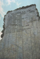 A stone monument is inscribed with a list of eruptions from the Dieng volcanic complex in central Java. The second column from the right lists fatalities (most recently 149 in 1979), which have occurred many times as a result of phreatic explosions and toxic gas emissions.
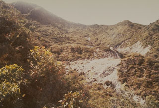 Hydrothermally altered rock within the Kawah Pakuwaja (also spelled Pakuwojo), one of the many craters of the Dieng Plateau, in 1973. The crater is located near summit of Gunung Pakuwaja, one of the larger cones of the Dieng volcanic complex. Kawah Pakuwaja is one of the most active craters at Dieng and has produced several phreatic explosions during historical time.
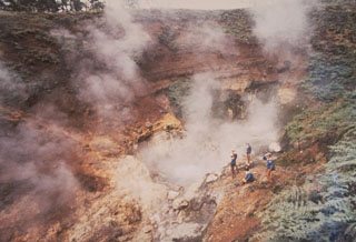 Scientists from the Volcanological Survey of Indonesia monitor the steaming Condrodimuko crater in the Dieng volcanic complex of central Java. The Dieng plateau contains a large amount of phreatic explosion craters, many of which have erupted during historical times, sometimes with fatal consequences. The only known eruption in the Kawah Condrodimuko area took place in December 1954, when an eruption was observed ejecting a thick black plume for half an hour.
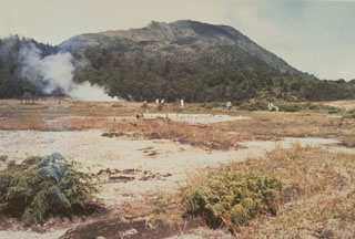 A plume rises from the Kawah Sikidang thermal area, one of the most visited in the Dieng volcanic complex. The Bisma cone is in the background to the SW. Kawah Sikidang is one of several craters at Dieng that have produced phreatic eruptions during historical time.
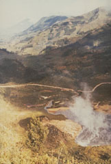 Kawah Sileri is one of many craters in the Dieng volcanic complex that have erupted in historical time. This 1973 photo shows a plume at the crater where a 2-3 minute explosive eruption on 13 December 1964, killed 114 people. Kawah Sileri, located NE of the village of Dieng, is one of the northernmost craters in the Dieng complex.
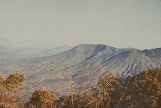 Gunung Bisma (center), seen here from the east, is a larger cone of the Dieng Volcanic Complex. It contains a valley that opens to the SE. The cone to the right of Bisma that contains erosional valleys radiating from the summit is Gunung Seroja.
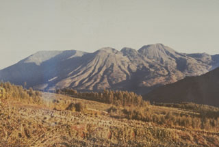 The Dieng volcanic complex, seen here from the SE, has numerous small craters and cones of Pleistocene-to-Holocene age over an area of 6 x 14 km. Minor phreatic eruptions have occurred in historical time, sometimes associated with hazardous gas emissions. The volcanic terrain of the Dieng plateau contains the oldest temples in Java.
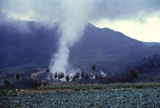 A plume rises above Kawah Sileri crater in the Dieng volcanic complex, one of many Dieng craters to have erupted in historical time. It was also the site of a relatively small but devastating eruption in 1964 that killed 114 people. The slopes of Gunung Prahu lie behind Kawah Sileri to the NE.
There are no samples for Dieng Volcanic Complex in the Smithsonian's NMNH Department of Mineral Sciences Rock and Ore collection.
| Copernicus Browser | The Copernicus Browser replaced the Sentinel Hub Playground browser in 2023, to provide access to Earth observation archives from the Copernicus Data Space Ecosystem, the main distribution platform for data from the EU Copernicus missions. |
| MIROVA | Middle InfraRed Observation of Volcanic Activity (MIROVA) is a near real time volcanic hot-spot detection system based on the analysis of MODIS (Moderate Resolution Imaging Spectroradiometer) data. In particular, MIROVA uses the Middle InfraRed Radiation (MIR), measured over target volcanoes, in order to detect, locate and measure the heat radiation sourced from volcanic activity. |
| MODVOLC Thermal Alerts | Using infrared satellite Moderate Resolution Imaging Spectroradiometer (MODIS) data, scientists at the Hawai'i Institute of Geophysics and Planetology, University of Hawai'i, developed an automated system called MODVOLC to map thermal hot-spots in near real time. For each MODIS image, the algorithm automatically scans each 1 km pixel within it to check for high-temperature hot-spots. When one is found the date, time, location, and intensity are recorded. MODIS looks at every square km of the Earth every 48 hours, once during the day and once during the night, and the presence of two MODIS sensors in space allows at least four hot-spot observations every two days. Each day updated global maps are compiled to display the locations of all hot spots detected in the previous 24 hours. There is a drop-down list with volcano names which allow users to 'zoom-in' and examine the distribution of hot-spots at a variety of spatial scales. |
|
WOVOdat
Single Volcano View Temporal Evolution of Unrest Side by Side Volcanoes |
WOVOdat is a database of volcanic unrest; instrumentally and visually recorded changes in seismicity, ground deformation, gas emission, and other parameters from their normal baselines. It is sponsored by the World Organization of Volcano Observatories (WOVO) and presently hosted at the Earth Observatory of Singapore.
GVMID Data on Volcano Monitoring Infrastructure The Global Volcano Monitoring Infrastructure Database GVMID, is aimed at documenting and improving capabilities of volcano monitoring from the ground and space. GVMID should provide a snapshot and baseline view of the techniques and instrumentation that are in place at various volcanoes, which can be use by volcano observatories as reference to setup new monitoring system or improving networks at a specific volcano. These data will allow identification of what monitoring gaps exist, which can be then targeted by remote sensing infrastructure and future instrument deployments. |
| Volcanic Hazard Maps | The IAVCEI Commission on Volcanic Hazards and Risk has a Volcanic Hazard Maps database designed to serve as a resource for hazard mappers (or other interested parties) to explore how common issues in hazard map development have been addressed at different volcanoes, in different countries, for different hazards, and for different intended audiences. In addition to the comprehensive, searchable Volcanic Hazard Maps Database, this website contains information about diversity of volcanic hazard maps, illustrated using examples from the database. This site is for educational purposes related to volcanic hazard maps. Hazard maps found on this website should not be used for emergency purposes. For the most recent, official hazard map for a particular volcano, please seek out the proper institutional authorities on the matter. |
| IRIS seismic stations/networks | Incorporated Research Institutions for Seismology (IRIS) Data Services map showing the location of seismic stations from all available networks (permanent or temporary) within a radius of 0.18° (about 20 km at mid-latitudes) from the given location of Dieng Volcanic Complex. Users can customize a variety of filters and options in the left panel. Note that if there are no stations are known the map will default to show the entire world with a "No data matched request" error notice. |
| UNAVCO GPS/GNSS stations | Geodetic Data Services map from UNAVCO showing the location of GPS/GNSS stations from all available networks (permanent or temporary) within a radius of 20 km from the given location of Dieng Volcanic Complex. Users can customize the data search based on station or network names, location, and time window. Requires Adobe Flash Player. |
| DECADE Data | The DECADE portal, still in the developmental stage, serves as an example of the proposed interoperability between The Smithsonian Institution's Global Volcanism Program, the Mapping Gas Emissions (MaGa) Database, and the EarthChem Geochemical Portal. The Deep Earth Carbon Degassing (DECADE) initiative seeks to use new and established technologies to determine accurate global fluxes of volcanic CO2 to the atmosphere, but installing CO2 monitoring networks on 20 of the world's 150 most actively degassing volcanoes. The group uses related laboratory-based studies (direct gas sampling and analysis, melt inclusions) to provide new data for direct degassing of deep earth carbon to the atmosphere. |
| Large Eruptions of Dieng Volcanic Complex | Information about large Quaternary eruptions (VEI >= 4) is cataloged in the Large Magnitude Explosive Volcanic Eruptions (LaMEVE) database of the Volcano Global Risk Identification and Analysis Project (VOGRIPA). |
| EarthChem | EarthChem develops and maintains databases, software, and services that support the preservation, discovery, access and analysis of geochemical data, and facilitate their integration with the broad array of other available earth science parameters. EarthChem is operated by a joint team of disciplinary scientists, data scientists, data managers and information technology developers who are part of the NSF-funded data facility Integrated Earth Data Applications (IEDA). IEDA is a collaborative effort of EarthChem and the Marine Geoscience Data System (MGDS). |

