Report on Nyiragongo (DR Congo) — April 2014

Bulletin of the Global Volcanism Network, vol. 39, no. 4 (April 2014)
Managing Editor: Richard Wunderman.
Edited by Jen Fela.
Nyiragongo (DR Congo) Lava lake dynamic but largely at low levels during mid-2011
Please cite this report as:
Global Volcanism Program, 2014. Report on Nyiragongo (DR Congo) (Fela, J., and Wunderman, R., eds.). Bulletin of the Global Volcanism Network, 39:4. Smithsonian Institution. https://doi.org/10.5479/si.GVP.BGVN201404-223030
Nyiragongo
DR Congo
1.52°S, 29.25°E; summit elev. 3470 m
All times are local (unless otherwise noted)
Information from observers monitoring Nyiragongo is intermittent and difficult to obtain because of ongoing difficulties related to securing funding for the observatory in Goma. A team of scientists visited Nyiragongo during 30 May-9 June 2011; this report is based on two published reports describing that visit. The first report (Burgi, 2011) originally appeared in French. The report said the expedition included team members from the Société de Volcanologie Geneve (SVG, Geneva, Switzerland), the Second University of Naples (Naples, Italy), INGV Catania (Catania, Italy), l'Observatoire Volcanologique de Goma (D.R. Congo), and the United Nations Office of Project Services (UNOPS) (Copenhagen, Denmark). The second report consisted of an article (Burgi and others, 2014) published in May 2014 in the Journal of Geophysical Research. Information from observers monitoring Nyiragongo is intermittent and difficult to obtain because of ongoing difficulties related to securing funding for the observatory in Goma.
In BGVN 35:09, in the caption for figure 45, we reported that during June 2010 Nyiragongo's lava lake rim or levee (labeled z) was 15-20 m above the crater floor (e) and was confined within an almost circular scoria wall (y). In the SVG report covering the June 2011 visit, it was reported in a caption for the same figure that "The lava lake rim or levee (z) was 6 m above the crater floor (e) in June 2010, which was not the case in May 2011, since the edge W had collapsed in the meantime."
The team employed a hand-held portable infrared-laser rangefinder with integral tilt meter. Surveying from the second terrace (y) allowed the team to estimate the lava lake's E-W axis, 260 m; and the N-S axis, 228 m. Those diameters enabled the team to estimate the lake surface area to be 46,000 m2, an increase of 6,000 m2 since June 2010.
The measurements during 30 May-9 June 2011 also indicated that the level of the chilled lava on the crater floor, 128-130 m below the second terrace, had not changed since 2010 (last two points at right in figure 51). This defied a simple linear extrapolation of the curve for the previous few years, which projected the crater floor would undergo continued rise in 2011. The team concluded that the activity of the lava lake must have declined. The team found a lack of evidence for lava overflow leaving deposits on the crater floor for almost a year, again consistent with no increase in lava lake level.
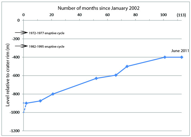 |
Figure 51. A diagram showing the level (comparative elevation) of Nyiragongo's active crater floor, in meters below the crater rim, during January 2002 to June 2011. The last data point is from the field visit discussed here. The January 2002 level of the crater floor is not known with precision, but was probably between 900 and 1000 m below the rim. This plot is a continuation of the one presented as figure 46 in BGVN 35:09. Burgi and others (2014) discuss the absolute elevation of the crater floor during the visit, 3,025 m (a.s.l). High levels from eruptions during 1972-1977 and 1982-1995 are noted with arrows. Taken from Burgi (2011). |
The team first found that the level of the lava lake had receded to an elevation ~15 m below the edge of the pit crater. The lava lake's elevation was stable until late afternoon on 3 June, when a loud noise and a "large burst" occurred within the lava lake. Lava drained from the lava lake, lowering its surface by 25-30 m in less than 1 minute. The team estimated that overall this drainage swept away more than 1 x 10⁶ m3 of magma within a few minutes. In the subsequent hours, the convective motion of the lava lake ceased and was followed by strong strombolian eruptions in the northern part of the lava lake. In this phase, material from the lake sprayed to heights of ~50 m above the lake.
Compared to the edge of the pit crater, the lava lake level continued to drop during 4 June-6 June, with a total drop (including the first major pulse) of ~33 m, placing the lava lake surface to almost 45 m below the edge of the pit crater by 8 June (figure 52). By the end of the team's crater visit, the level had reached ~55 below the edge of the pit crater.
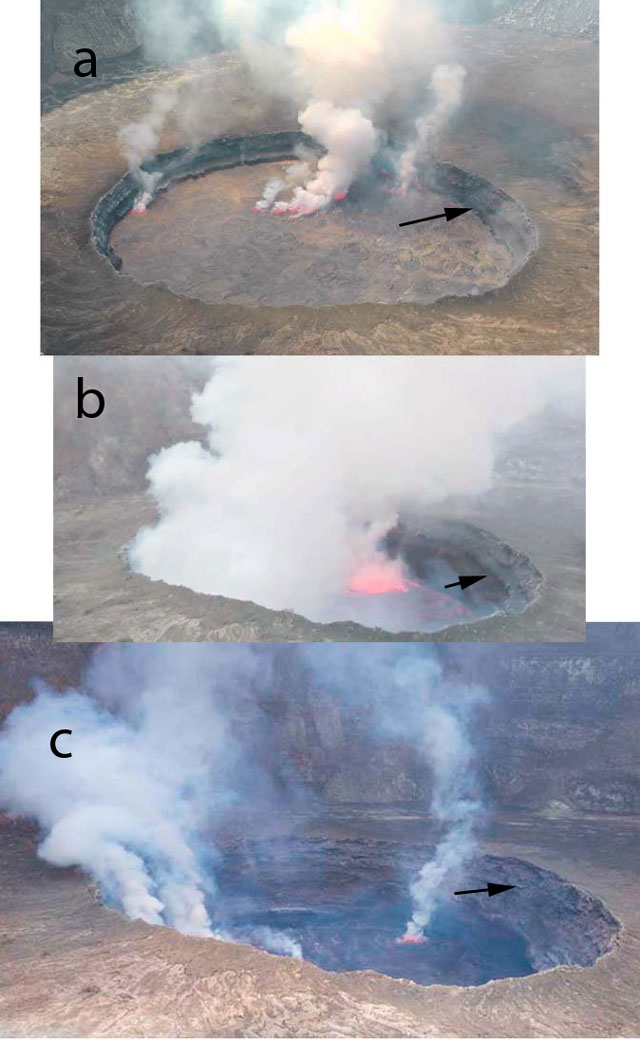 |
Figure 52. Photos of Nyiragongo's crater floor and the pit crater within it, documenting the rapid drop in the level of the lava lake seen during 2-8 June 2011. The white arrow in each photo is showing the same datum on the wall of the pit crater, 12 m below the pit crater's rim. For the specified times and dates, the following values represent the vertical distance of the lava lake below the edge of the pit crater: (A) 1400 on 2 June, 12 m; (B) 0815 on 4 June, 37 m; and (C) 0945 on 8 June, 45 m. Photos courtesy of Patrick Marcel, published in Burgi and others (2014). |
Based on their measurements and the assumption that the deeper edifice takes the shape of an inverted cone, the team concluded that the volume of magma contained in the lava lake during their June 2011 visit was approximately 10 x 106 m3. Small but repeated movements of the edifice produced by the fluctuating level of the lava lake were interpreted as sufficient to weaken the edifice, which had already fissured during previous eruptions.
Satellite data and imagery during July 2012. The Toulouse Volcanic Ash Advisory Center (VAAC) reported that beginning on 3 July 2012 Nyiragongo emitted a series of ash plumes up to an altitude of 5.5 km, or approximately 2 km above the summit. They noted that sulfur dioxide emissions from Nyiragongo are common, but ash emissions are unusual.
Figure 53 shows MODIS imagery of Nyiragongo discussed by the NASA Earth Observatory. They commented on the absence of signs of increased activity and that activity at the volcano appeared similar to that during the previous 10 years.
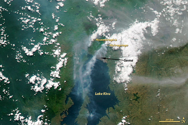 |
Figure 53. MODIS Aqua satellite image on 5 July 2012 showing emissions streaming SW from Nyiragongo, with a plume emitting from nearby Nyamuragira also visible. Courtesy NASA Earth Observatory. |
References. Burgi, P.-Y. (2011), Rapport de L'activité éruptive du Nyiragongo, MaiJuin, 2011, Societe de Volcanologie Geneve, 110 Bulletin Mensuel, pp. 3-8.
Burgi, P.-Y., T. H. Darrah, D. Tedesco, and W. K. Eymold, 2014, Dynamics of the Mount Nyiragongo lava lake, J. Geophys. Res., Solid Earth, 119, pp. 4106-4122, doi:10.1002/2013JB010895.
Geological Summary. The Nyiragongo stratovolcano contained a lava lake in its deep summit crater that was active for half a century before draining catastrophically through its outer flanks in 1977. The steep slopes contrast to the low profile of its neighboring shield volcano, Nyamuragira. Benches in the steep-walled, 1.2-km-wide summit crater mark levels of former lava lakes, which have been observed since the late-19th century. Two older stratovolcanoes, Baruta and Shaheru, are partially overlapped by Nyiragongo on the north and south. About 100 cones are located primarily along radial fissures south of Shaheru, east of the summit, and along a NE-SW zone extending as far as Lake Kivu. Many cones are buried by voluminous lava flows that extend long distances down the flanks, which is characterized by the eruption of foiditic rocks. The extremely fluid 1977 lava flows caused many fatalities, as did lava flows that inundated portions of the major city of Goma in January 2002.
Information Contacts: Pierre Vetsch, Société de Volcanologie Genève (SVG), PO Box 6423, CH-1211 Geneva 6, Switzerland (URL: http://www.volcan.ch/); Jeff Schmaltz, LANCE MODIS Rapid Response Team, Goddard Space Flight Center, NASA Earth Observatory (URL: http://earthobservatory.nasa.gov); and Toulouse Volcanic Ash Advisory Center (VAAC), Météo-France, 42 Avenue Gaspard Coriolis, F-31057 Toulouse cedex, France (URL: http://www.meteo.fr/vaac/).