Report on Sinabung (Indonesia) — October 2014

Bulletin of the Global Volcanism Network, vol. 39, no. 10 (October 2014)
Managing Editor: Richard Wunderman.
Sinabung (Indonesia) Frequent eruptions, pyroclastic flows, and advancing lava-flow lobe during May-October 2014
Please cite this report as:
Global Volcanism Program, 2014. Report on Sinabung (Indonesia) (Wunderman, R., ed.). Bulletin of the Global Volcanism Network, 39:10. Smithsonian Institution. https://doi.org/10.5479/si.GVP.BGVN201410-261080
Sinabung
Indonesia
3.17°N, 98.392°E; summit elev. 2460 m
All times are local (unless otherwise noted)
On the basis of ash-plume reports from the aviation community around the time of this reporting, Sinabung ranked as the most active volcano in Indonesia, the world's fourth-most populated country. The volcano is located in the Karo Regency of N Sumatra (figure 19). The latest eruption began mid-September 2013; activity through April 2014 was reported in BGVN 39:01. This report describes the continuing volcanic activity from May 2014 through October 2014, primarily drawn from reports issued by the Indonesian Center of Volcanology and Geological Hazard Mitigation (CVGHM) and reports from the Darwin Volcanic Ash Advisory Centre (VAAC). During this reporting interval, many photographs of Sinabung emerged online, some with outstanding information content, but far too numerous to either catalog or feature here.
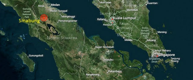 |
Figure 19. Sinabung is located in Karo Regency on the island of Sumatra in the Indonesian archipelago. Sinabung resides NE of the closest margin of Toba caldera, the largest volcano of this type known on Earth. The elongate caldera contains a lake 100 km long. The central portion of the lake is occupied by a prominent island (a classic resurgent dome). Taken from Darwin VAAC. |
The Darwin VAAC describes their jurisdiction as covering ~150 active volcanoes located in the South Pacific region from the Philippines to the Solomon Islands, including Indonesia. They issued 1,511 Volcanic Ash Advisories (VAAs) during the 12-month period, 1 July 2013 to 30 June 2014 (their fiscal year 13/14; Darwin VAAC, 2014). During the next 7-month interval (ending 31 January 2015) the VAAC issued 742 reports (Darwin VAAC, 2015). These VAAs are part of their mission to create materials for warning and guidance to the aviation community, including aviation meteorologists, air traffic control offices, and airlines (e.g. dispatchers and pilots).
One way to assess the production of noteworthy ash plumes at volcanoes is to consider the number of VAAs issued, an assessment found in their Management Reports (Darwin VAAC, 2014; 2015). The Darwin VAAC issued Management Reports that both cover and extend beyond (i.e., both earlier and later than) this reporting interval (May to October 2014). Specifically, their reports cover 1 July 2013-30 June 2014 and 1 July 2014-31 January 2015. In both those intervals the largest number of VAAs issued for any single volcano in their region went to Sinabung. In the earlier interval this consisted of 537 out of 1,511 total regional reports; in the later interval, 321 out of 742 total regional reports.
The table in the section "Data compilation" at the bottom of this report also highlights a case at 12:32 UTC on 22 May 2014 of a rapidly growing cloud around Sinabung plausibly associated with an eruption there. The cloud reached ~15.2 km altitude and was initially assessed as eruptive and ash bearing. At the time forecasters felt there was sufficient evidence the cloud contained ash to warrant an advisory. A more detailed assessment made later determined the cloud to probably have been a cumulonimbus cloud (abbreviated Cb; a towering vertical dense cloud often associated with thunderstorms and atmospheric instability). The case illustrates the challenge of creating VAAs rapidly with limited information and time for analysis, balanced against the desire for high accuracy (with low rates of false positives and false negatives). Darwin VAAC (2015) also described the region as one with "...moist tropical convection that makes remote sensing difficult for much of the year."
During the reporting interval, Sinabung was the scene of both lava flows and vigorous dome-building eruptions that discharged significant ash plumes and pyroclastic flows (PFs). Lava flows constructed a several kilometer long tongue or lobe of lava on the flank to the S-SE. These events accompanied elevated seismicity.
During the reporting interval the Aviation Colour Code (ACC) issued by the VAAC was generally Orange; however, during the week of 15-21 October, the ACC was Red.
The ACC is a four-color scale used to inform the needs of the aviation community. The four colors denoting increasing risk are Green, Yellow, Orange, and Red. According to the World Organization of Volcano Observatories' website, Orange connotes "Volcano is exhibiting heightened unrest with increased likelihood of eruption." Red connotes "Eruption is forecast to be imminent with significant emission of ash into the atmosphere likely."
The CVGHM uses a separate volcanic hazard status code to warn people in the region. The Darwin VAAC Weekly report issued for 29 October-4 November 2014 gave this overview of the eruption and the variation in CVGHM's volcanic hazard status: "On 14 September 2013, a new eruptive phase began. By mid-October the volcano was degassing almost daily with small phreatic eruptions. Seismic and visual activity continued to build into November. After nine powerful explosions in a 24 hour period, the Centre for Volcanology and Geological Hazard Mitigation (CVGHM) raised the Alert level to Level IV on 24 November 2013, the highest volcano rating. The status was decreased to Alert Level III on 8 April 2014."
During this reporting interval, lava flows advanced in the sector S- SE from the summit (figure 20). In accord with that lobe or tongue of lava, incandescent zones were at various times noted in different parts of the flows. As reported by CVGHM, avalanches from the front of the advancing lava flows occurred often. Scientists associated this process with a distinct seismic signal called an avalanche earthquake. CVGHM repeatedly warned residents that the lava flows and their associated avalanches could threaten areas to the S and SE within 5 km of the summit. Measurements of the length of this flow are included in the table at the bottom of this report. A previous map with clearer labels of the earlier flows appears as figure 16 in BGVN 39:01.
 |
Figure 20. Annotated photo showing the S-SE flank of Sinabung covered by an advancing lava flow (often referred to as lava tongue, 'lidah lava' in Indonesian). On 6 September 2014, the day of this photo, the lava flow was reported as measuring 2.915 km long from distal end to the vent area at or adjacent the summit lava dome. Although the upper slopes on the E (right) side are too cloudy to see, CVGHM had recorded the locations of the various dated flow margins there. Note the area on the upper flanks where some lava branched off the main lobe to create a series of small finger-shaped areas trending more to the W. Courtesy of CVGHM. |
Seismicity at Sinabung included avalanche earthquakes, low-frequency earthquakes, tectonic earthquakes, volcanic earthquakes and ongoing tremor. Totals and measured averages of these seismic events are included when available (see table at bottom). CVGHM reported that the dominating seismic signals, avalanche earthquakes and intervals of constant tremor, were associated with the instability of the growing lava dome and lava flows.
During this reporting interval, numerous eruptions took place, often generating ash plumes and in some cases pyroclastic flow. During the eruptions, some ash plumes were detected by satellite imagery. Ground-based observations were also important. For example, CVGHM often detected Sinabung eruptions, PFs, and plumes via webcam. Darwin VAAC also benefited from the CVGHM webcam data in several of their VAAs. The VAAC has also begun to use social media to both dispense and retrieve operationally relevant information (Darwin VAAC, 2015). This has aided VAAC forecaster's understanding of, for example, whether residents have noticed ashfall during times when ash is not discernable due to meteorological clouds (Darwin VAAC, 2015).
During May and October 2014, PFs had runout distances up to 4.5 km and ash plumes rose up to 5.2 km altitude. White or slightly discolored plumes were the most common type reported by CVGHM. These plumes sometimes rose to as high as on the order of 1 km over the summit.
Figure 21 is a map of Sinabung and towns surrounding the volcano.
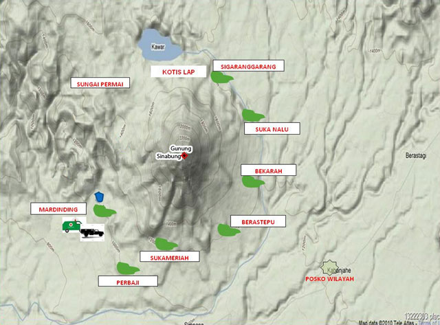 |
Figure 21. Relief map of Sinabung volcano and surrounding towns, some of which are named in reporting. The base map was made prior to the current eruption and the lava tongue descending the S-SE flank is not shown. For scale, the distance is ~3 km from the summit area N to the closest (S) margin of Kawar lake. Map found online at Pixshark.com and edited by Bulletin editors. |
Photographs. The following are photos documenting events at Sinabung during this reporting interval. Ancillary information pertaining to each photo can be found in a table at the bottom of this report.
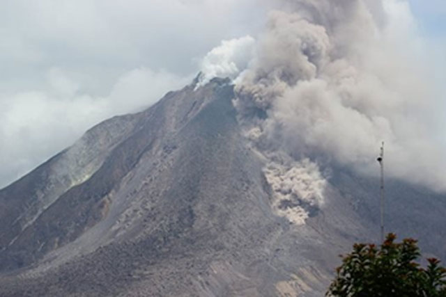 |
Figure 22. Photo of a pyroclastic flow (PF) descending Sinabung on 14 August 2014. Two PFs occurred that day, at 0728 UTC and 0750 UTC. The time that this photo was captured is unknown. Photographer unknown; photo posted on Facebook by CVGHM and taken from the 13-19 August 2014 Darwin VAAC weekly activity report. |
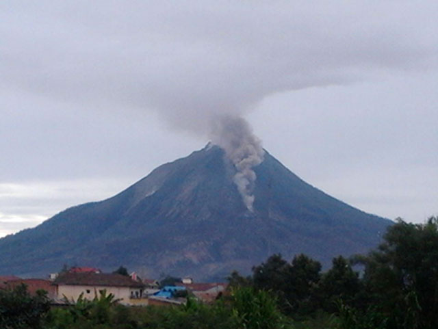 |
Figure 23. A pyroclastic flow (PF) captured at 0940 UTC on 2 September 2014. This PF traveled 1.5 km to the SE. Taken from the 27 August-2 September 2014 Darwin VAAC weekly activity report. |
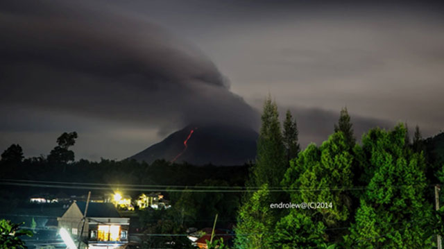 |
Figure 24. Sinabung in a low-light photo allegedly taken at 1444 UTC on 7 September 2014, which would make it about 46 minutes after Darwin VAAC reported an eruption. The ash plume rose 2 km above the summit and blew S. A rivulet of red glowing material descends an area of the flank. Bulletin editors interpret the rivulet as a lava flow (or possibly a glowing avalanche or both) traveling down the lava tongue on the S-SE flank. Copyrighted photo taken by Endro Lewa, posted on Facebook by CVGHM, and taken from the 3-9 September 2014 Darwin VAAC weekly activity report. |
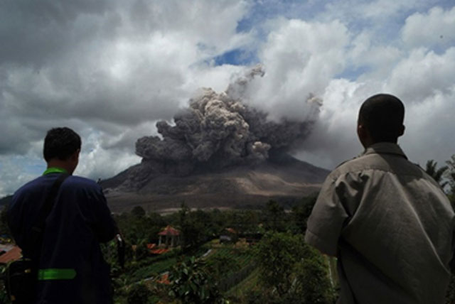 |
Figure 25. Eruption at Sinabung on 8 October 2014. This time and the location of this photo were unstated. Photo by the news agency AFP and taken from the 8-14 October 2014 Darwin VAAC weekly activity report. |
 |
Figure 26. (A) Ground-based photo of a Sinabung eruption column looking approximately NE on 19 October 2014. Photo was captured at 0731 UTC. The eruption column is obscured by weather clouds but is visible again above them in a small area. Photo was taken by Ricky Febriand, posted on Facebook by CVGHM, and taken from the 15-21 October 2014 Darwin VAAC weekly activity report. B. Aerial photo of Sinabung's eruption column on 20 October 2014. Photo was captured at 0736 UTC. Height of eruption column and position photo was taken are unknown. Photo taken by Ricky Febriand, posted on Facebook by CVGHM and taken from the 15-21 October 2014 Darwin VAAC weekly activity report. |
Data compilation. Table 4 summarizes activity at Sinabung from May-October 2014. Data sources include reporting by CVGHM (often the original source), the Darwin VAAC (their Volcanic Ash Advisories (VAAs), Weekly Activity Reports; and other reports), the Indonesian National Agency for Disaster Management (Badan Nacional Penanggulangan Bencana-BNPB), occasional news articles; and the Smithsonian-USGS Weekly Volcanic Activity Reports.
Table 4. A synthesis of Sinabung's reported activity from May-October 2014. The bulk of this table came from CVGHM and Darwin VAAC reporting unless otherwise stated. Dates and times are in some cases ambiguous as to local time (LT) or UTC (LT = UTC + 7). Abbreviations: pyroclastic flow, PF; Aviation Color Code, ACC; earthquake(s), EQ(s); maximum amplitude, max. amp.; and altitude, alt.
| Week | Remarks |
| 30 Apr-20 May 2014 | ACC: Orange |
| 21 May-31 May 2014 | ACC: Orange 22 May: At 1132 UTC, Darwin VAAC noted a suspicious, possibly ash bearing cloud around Sinabung in a MTSAT-2 IR image. In retrospective analysis, Darwin VAAC concluded the cloud was the beginning of a cumulonimbus (Cb) cloud forming due to atmospheric instability in the area (unrelated to the eruption). For more information, see text and the 21-27 May 2014 issue of the Darwin Weekly Activity Report. 26 May: Ash plume observed at 0132 UTC on MTSAT-2 satellite imagery. Plume extended 28 km SE at 3.4 km alt. Plume observed via webcam. Similar length ash plume again observed by satellite at 0432 UTC on 27th. VAA ended after plume no longer visible. |
| 01 Jun-17 Jun 2014 | Lava flow associated with dome growth. S and SE flank lava avalanches. Columns of white plumes rose 100-400 m over crater. Seismicity dominated by avalanche EQs and tremor, both associated with instability of dome and lava flows. 13th: Lava flow: ~2.796 km long. |
| 18 Jun-28 Jun 2014 | Visual monitoring from ~10 km ESE from summit (Post PGA Sinabung located in Ndokum Siroga village) confirmed ongoing dome growth and glowing areas of the lava flow. Avalanches from the flow front seen. 18-24th: Seismicity dominated by avalanche signals; minor deformation. |
| 29 Jun 2014 | CVMGH reported an eruption with a 4 km alt. ash plume. PF flows traveled 4.5 km SE. Ashfall noted in settlements of Sigarang-Garang and Sukanalu (figure 21). Earthquakes reached high (105 mm) amplitude for 64 minutes. Dome growth continued. A Xinhua news report from 29 June 2014, noted a reporter's telephone interview with a CVGHM authority; the basis for the article's claim of up to 14,382 people still evacuated. |
| 30 Jun-15 Jul 2014 | 8-14th: Real-time Seismic Amplitude Measurement (RSAM) values from 8-15th remained steady. SO2 flux: 1,252 metric tons/day. Dome growth and lava flows continued. 8 Jul: Thick white plume 100-200 m above summit. 38 avalanche EQs (max. amp. 2-70 mm). 9 Jul: Thick bluish plume to 100 m above summit. 54 avalanche EQs; continuous tremor (max. amp. 2-53 mm). 10 Jul: PF traveled up to 3 km S. Plumes of blue and brown color rose 200-2000 m above summit. 52 avalanche EQs and continuous tremor (max. amp. 2-53 mm.). 11 Jul: Thick white plume 300-1000 m above summit. 59 avalanche EQs; continuous tremor (max. amp. 2-52 mm). 12 Jul: Eruption at 2305; a PF moved ~4 km E. Ashfall at several places around Karo district. Maximum height of eruption column indeterminate. 88 avalanche EQs; 2 deep volcanic (VA) EQs. Continuous tremor (max. amp. 2-66 mm). No further evacuations reported. 13 Jul: Thick white plume to 400 m over summit. 92 avalanche EQs; 1 deep volcanic (VA) EQ. Continuous tremor (max. amp. 2-45 mm). 14 Jul: Lava flow: 2.824 km long. Thick white to bluish plume to 200 m above summit. 83 avalanche EQs; 3 deep volcanic (VA) EQs; continuous tremor (max. amp. 2-62 mm). 15th (until 0600LT): 34 avalanche EQs; continuous tremor (max. amp. 2-42 mm). |
| 16 Jul-29 Jul 2014 | 23 Jul: Molten lava captured in photo posted by CVGHM at 2207 on 22 July 2014 UTC. No ash identified on satellite imagery. No Volcanic Ash Advisories (VAAs) issued. |
| 23 Jul-29 Jul 2014 | ACC: Orange |
| 13 Aug-19 Aug 2014 | ACC: Orange 13 Aug: 94 avalanche EQs; 2 deep volcanic EQs; 2 deep tectonic EQs; and continuous tremor. Lava ~1000-1500 m from summit moving SE. 14 Aug: PFs at 0728UTC and 0750UTC (figure 22). PFs traveled 1-1.5 km. White plumes rose 300-1000 m above the summit. 102 avalanche EQs; 3 deep volcanic EQs; and continuous tremor. Lava flow: ~2.904 km long. |
| 20 Aug-26 Aug 2014 | ACC: Orange 20-23 Aug: White plumes rose 100-300 m over crater. Continuous tremor. Avalanche EQs reported on 20-21 and 23 Aug. 22 Aug: PFs traveled 1.5 km to SE. 3 deep volcanic EQs recorded. 23 Aug: 3 southerly moving PFs observed. (1) 0356 UTC, and travelling 2 km; (2) 1140 UTC, and travelling 2 km; (3) 0409 UTC and traveled 1.5 km. |
| 27 Aug-02 Sep 2014 | ACC: Orange 29 Aug: PF traveled 1.5 km to SE. Time of PF is unknown. 2 Sep: PF at 0940 UTC traveled a distance of 1.5 km SE (figure 23). |
| 03 Sep-09 Sep 2014 | ACC: Orange 5-11 Sep: White plumes, appeared bluish on some days, rose 50-500 m over crater. Avalanche EQs (average of 96 events/day), low frequency EQs (average of 75 events/day), deep tectonic EQs, and deep volcanic EQs often recorded. Avalanches, travelling various distances observed moving SE and S. 6 Sep: Lava flow: 2.915 km long (figure 20). 7 Sep: Eruption at 1358 UTC that lasted 19 minutes. Plume rose 2 km above summit and ash from plume blown S (figure 24). Eruption's PFs traveled max distances of 2 km to SE. 1 eruption earthquake noted. |
| 10 Sep-16 Sep 2014 | 10-16 Sep: RSAM stable. 12-16 Sep: White plumes rose 100-1000 m over crater. On occasions, the plumes had a bluish tint. 12 Sep: Ash plume on webcam moving E/NE at 0140 UTC. Plume not identifiable on satellite imagery due to overlying clouds. Plume height of 3.7 km alt. (based on model data). Advisory terminated on UTC 13th at 0732 after satellite imagery indicated ash had dissipated. 15 Sep: PF traveled 2.5 km to SE. |
| 17 Sep-23 Sep 2014 | ACC: Orange 12-20 Sep: Average total of avalanche EQs was 110 events/day, average for volcanic EQs was 1 event/day, average for low frequency EQs was 75 events/day and tremor was continuously recorded. 17-20 Sep: White (sometimes bluish) plumes rose 100-200 m; RSAM stable. 18th: PFs reached 2 km to S. |
| 24 Sep-30 Sep 2014 | ACC: Orange 24 Sep: Eruption at 1343 emitted hot ash and gravel. Eruption lasted ~15 minutes and a PF descended ~2 km from summit. Eruption column height could not be determined. 4,700 residents remain in evacuation centers. 30 Sep: Eruption at 1720 sent volcanic ash 2 km above the summit. A PF traveled 3.5 km from summit; PF's direction was unstated. Recent eruptions covered settlements and agricultural lands around Sinabung with ash. News sources noted that farmers harvested their crops early to reduce losses. |
| 01 Oct-07 Oct 2014 | 5 Oct: Four eruptions took place. (1) 0146: volcanic ash sent 2 km over crater and a PF moved max distance of 4.5 km S; (2) 0638: PFs traveled 2.5 km S; (3) 0736: PFs traveled 3 km S; and (4) 0753: eruption column with ash rose 3 km and PFs traveled 4.5 km S. No additional refugees were reported. Two other eruptions that caused PFs were reported at 0900 and 1200. 6 Oct: Low-level eruption observed on webcam starting at 0120 UTC. Eruption plume moved E and a PF also seen moving below the summit. 7 Oct: Volcanic ash at 5.2 km alt. moving S. Ash not identifiable in satellite imagery. |
| 08 Oct-14 Oct 2014 | ACC: Orange 8 Oct: At 0543 UTC, an initial VAA issued for an in-progress eruption. Eruption first noted through webcam, but no ash was seen in satellite imagery. Eruption produced a 4.9 km eruption column and a PF (both were observed by webcam at 0543 UTC) (figure 25). Another eruption observed at 2336 UTC by webcam. 9 Oct: A low-level plume moving NE seen in satellite imagery at 0332 UTC. According to a 0531 UTC VAA, several eruptions were observed over the last 6 hours via webcam. Darwin VAAC weekly report noted that eruption from 8th reached the provincial capital Medan and disrupted flights on the 9th. 10 Oct: Eruption was observed via webcam at 0200 UTC and through satellite imagery at 0132 UTC. In the imagery from 0132 UTC, an eruption plume extended 30 NM NE. Volcanic ash was noted at 0335 UTC in satellite imagery and was last seen at 0632 UTC extending 30 NM NE. 11 Oct: Webcam captured a 3 km ash plume drifting SW. 12 Oct: Volcanic ash on webcam at 0030 UTC to SE at 3.1 km alt. Volcanic ash was again observed at 0600 UTC via webcam. 14 Oct: Ash plume recorded by webcam rising 4 km and moving SW. |
| 15 Oct-21 Oct 2014 | ACC: Red 15 Oct: At 0036 UTC, an eruption took place that sent ash 500 m over crater and a PF 2.5 km (direction unstated). At 0200 UTC, Sinabung was observed on webcam to 4.3 km alt. Eruption column moved N. Continuous small eruptions seen via webcam, during daylight hours. 17 Oct: Ash rose to ~ 3.7 km alt. In photos taken by a pilot, ash seen extending ~15 mi to W of Sinabung. On ground, PF extended 3.5 km and ash was thrown up 2.5 km, according to a picture taken at 0409 UTC. 19-20 Oct: Eruption columns seen via both ground-based and aerial images (figure 26) |
| 22 Oct-28 Oct 2014 | ACC: Orange 23 Oct: Eruption observed via webcam. Eruption column rose to 4.3 km alt. and extended 10 NM to N at 0400 UTC. 25 Oct: Eruption at 0249 UTC seen via webcam. Volcanic ash at 4.6 km alt. identifiable through satellite images from 0332 UTC. Plume extended 15 NM to W-NW. Eruptions also seen via webcam at 1000 UTC and 2312 UTC. In a 2331 UTC VAA, ash plume reported at 3 km and drifting E based on webcam. 26 Oct: Activity reported as high. PFs traveled 3.5 km S on two occasions and an ash plume rose 2 km over crater. Lava moved distances of 700-1000 m from summit. 27 Oct: Eruption at 1013 UTC seen via webcam. BNPB reported ~3,000 people remained in evacuation shelters. |
| 29 Oct-30 Oct 2014 | ACC: Orange |
References. Associated Press, 2014, Volcano in Western Indonesia erupts again, accessed on 28 September 2014, (URL: http://abcnews.go.com/International/wireStory/volcano-western-indonesia-erupts-25720623 )
Darwin VAAC, (6 August) 2014, VAAC Darwin Management Report [discussing 1 July 2013 to the 30 June 2014], International Civil Aviation Organization (ICAO); Eighteenth Meeting of the Meteorology Sub-Group (Met Sg/18) Of Apanpirg; ICAO Regional Sub-Office, Beijing, China; 18–21 August 2014 [Agenda Item 7.4: Research, development and implementation issues in the MET field, [7.4] Advisories and warnings, MET SG/18 - IP/17; Agenda Item 7.4; 6 August 2014; (Presented by Australia)]; 5 pp. (URL: http://www.icao.int/APAC/Meetings/2014 METSG18/IP17_AUS AI.7.4 - VAAC Darwin Management.pdf )
Darwin VAAC, (18 February) 2015, Darwin VAAC Management Report [discussing 1 July 2014-31 January 2015], International Civil Aviation Organization (ICAO), Fifth Meeting of Meteorological Hazards Task Force (MET/H TF/5), Seoul, Republic of Korea, 18 March 2015 [Thirteenth Meeting of the Asia/Pacific Regional Opmet Bulletin Exchange Working Group (Robex Wg/13), ROBEX WG/13 & MET/H TF/5 – WP/C6; Agenda Item (conjoint session) 2 (Presented by Australia)] (URL: http://www.icao.int/APAC/Meetings/2015 ROBEXWG13/WP-C6 - AI.2 - AUS - Darwin VAAC Management Report.pdf )
Indonesian National Agency for Disaster Management (Badan Nacional Penanggulangan Bencana-BNPB), 2014, Four time Sinabung, Normal Community Activity, accessed on 6 October 2014, (URL: http://bnpb.go.id/berita/2211/empat-kali-sinabung-meletus-masyarakat-beraktivitas-normal)
The Jakarta Post/Asia News Network, 2014, Mount Sinabung erupts again, accessed on 6 October 2014, (URL: http://news.asiaone.com/news/asia/mount-sinabung-erupts-again)
Okezone.com, 2014, accessed on 28 September 2014, (URL: http://news.okezone.com/read/2014/10/01/340/1046715/hujan-abu-gunung-sinabung-guyur-karo-petani-menderita )
Pixshark.com, accessed on 7 April 2015 (URL: http://pixshark.com/peta-gunung-sinabung.htm)
World Organizations of Volcano Observatories (WOVO), Aviation Colour Codes, accessed on 8 April 2015, (URL: http://www.wovo.org/aviation-colour-codes.html)
Xinhua News Agency, 2014, 2nd LD Writethru: Mount Sinabung in Indonesia erupts, triggering massive evacuation, accessed on 29 June 2014, (URL: http://www.globalpost.com/article/6190943/2014/06/29/2nd-ld-writethru-mount-sinabung-indonesia-erupts-triggering-massive)
Xinhua News Agency, 2014, Mount Sinabung erupts in Sumatra, Indonesia, accessed on 28 September 2014, (URL: http://english.cntv.cn/2014/09/24/ARTI1411549583755731.shtml).
Geological Summary. Gunung Sinabung is a Pleistocene-to-Holocene stratovolcano with many lava flows on its flanks. The migration of summit vents along a N-S line gives the summit crater complex an elongated form. The youngest crater of this conical andesitic-to-dacitic edifice is at the southern end of the four overlapping summit craters. The youngest deposit is a SE-flank pyroclastic flow 14C dated by Hendrasto et al. (2012) at 740-880 CE. An unconfirmed eruption was noted in 1881, and solfataric activity was seen at the summit and upper flanks in 1912. No confirmed historical eruptions were recorded prior to explosive eruptions during August-September 2010 that produced ash plumes to 5 km above the summit.
Information Contacts: Indonesian Center of Volcanology and Geological Hazard Mitigation (CVGHM) (also known as Pusat Vulkanologi dan Mitigasi Bencana Geologi-PVMBG), Jalan Diponegoro 57, Bandung 40122, Indonesia (URL: http://vsi.esdm.go.id/); Indonesian National Agency for Disaster Management (Badan Nacional Penanggulangan Bencana-BNPB), Gedung Graha 55 Jl. Tanah Abang II No. 57, 10120, Jakarta Pusat (URL: http://www.bnpb.go.id/); and Darwin Volcanic Ash Advisory Centre (VAAC), Bureau of Meteorology, Northern Territory Regional Office, PO Box 40050, Casuarina, NT 0811, Australia (URL: http://www.bom.gov.au/info/vaac/).