Report on Nyiragongo (DR Congo) — January 2017

Bulletin of the Global Volcanism Network, vol. 42, no. 1 (January 2017)
Managing Editor: Edward Venzke.
Research and preparation by Robert Andrews.
Nyiragongo (DR Congo) New vent in the summit crater during February-April 2016; lava lake active throughout 2011-2016
Please cite this report as:
Global Volcanism Program, 2017. Report on Nyiragongo (DR Congo) (Venzke, E., ed.). Bulletin of the Global Volcanism Network, 42:1. Smithsonian Institution. https://doi.org/10.5479/si.GVP.BGVN201701-223030
Nyiragongo
DR Congo
1.52°S, 29.25°E; summit elev. 3470 m
All times are local (unless otherwise noted)
Nyiragongo holds one of the world's largest lava lakes, having been observed since at least 1971 (CSLP 21-71). Lava flows in 1977 and 2002 had deadly consequences for the city of Goma, which lies about 15 km S of the summit. The last Bulletin (BGVN 39:04) summarized observations made by a team of scientists that visited the volcano during 30 May-9 June 2011, and Toulouse Volcanic Ash Advisory Center (VAAC) notices posted in July 2012. This report covers activity from November 2011 through December 2016. Ground reports of activity are infrequent, though there are intermittent tourist expeditions, and a visit by scientists in March 2016 provided visual observations detailing changes in the crater and vent morphology.
Excellent pictures of the lava lake within the crater were taken in June 2010 by photographer Olivier Grunewald, while on an expedition to the volcano with observatory scientists doing fieldwork. These images, 28 total, were provided by Nelson (2011) for a news article; three are shown below (figures 54-56).
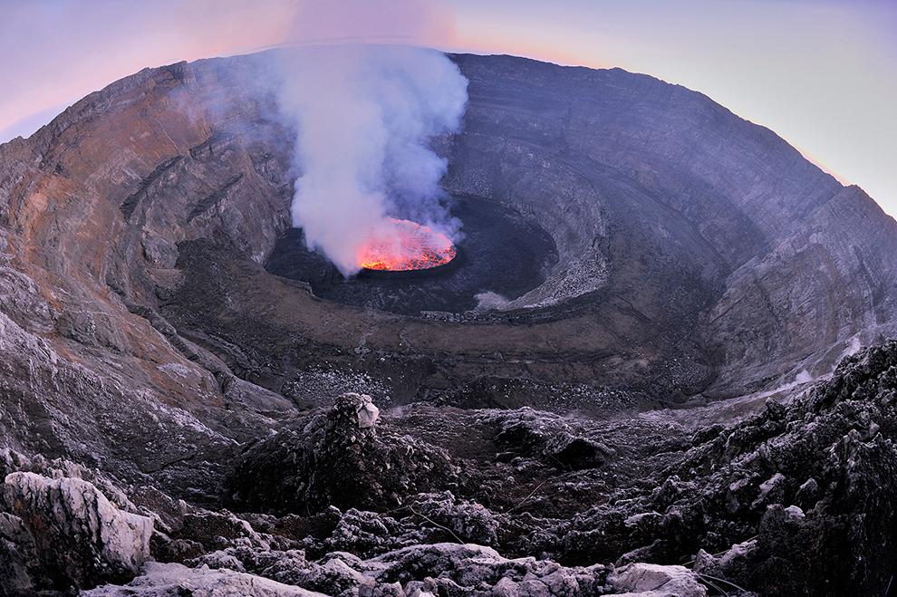 |
Figure 54. The lava lake within the Nyiragongo crater, June 2010. Photo by Olivier Grunewald in Nelson (2011). |
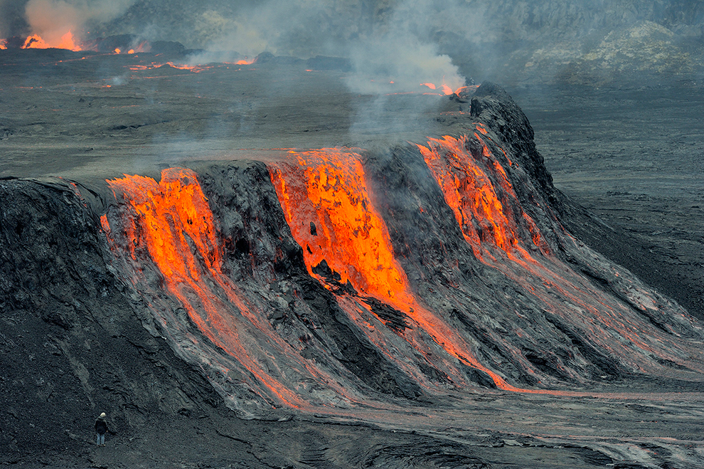 |
Figure 55. Close-up daytime view of lava overflowing from the elevated active pit within the summit crater, June 2010. Note person for scale at lower left. Photo by Olivier Grunewald in Nelson (2011). |
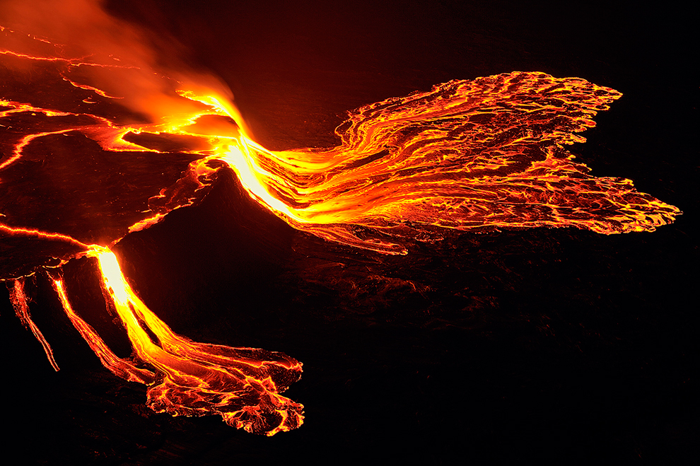 |
Figure 56. Night view from the crater rim of lava overflowing from the elevated active pit within the summit crater, June 2010. Photo by Olivier Grunewald in Nelson (2011). |
Emissions and thermal anomalies. A nearly daily record of thermal alerts identified from the MODIS Agua and Terra satellite sensors has been generated by MODVOLC since 2002; the MODVOLC and MIROVA systems recorded nearly daily thermal anomalies during 2015 and at least through December 2016.
According to NASA's Earth Observatory, a satellite image acquired on 15 November 2011 showed heat coming from the active lava lake. The Toulouse VAAC reported that, according to a Volcano Observatory Notices for Aviation (VONA) issued by OVG (Observatoire Volcanologique de Goma), a gas plume composed mostly of sulfur dioxide rose from the crater on 1 November 2012. Another satellite image, acquired on 29 July 2013 and analyzed by NASA's Earth Observatory, again showed incandescence coming from the active lava lake in the summit crater; a diffuse blue plume drifted N.
A satellite image from 29 January 2014 showed a gas-and-steam plume rising from Nyiragongo. On 9 February 2015, clear skies permitted a view from space of plumes venting from Nyamuragira (figure 57, top) and Nyiragongo (figure 57, bottom) volcanoes.
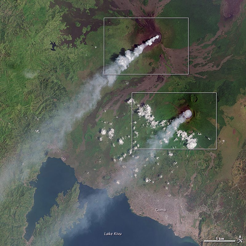 |
Figure 57. The natural-color satellite image above was acquired on 9 February 2015 by the Operational Land Imager (OLI) instrument on Landsat 8, showing a broad view of the region, with Nyamuragira to the N and Nyiragongo to the S, separated by a distance of about 15 km. Courtesy of NASA Earth Observatory. |
New vent in crater, February 2016. Activity intensified on 28 February 2016, prompting OVG to dispatch a team of scientists to the crater. Starting at 0400 on 29 February, local residents began to hear frequent rumblings coming from the volcano almost every minute. These were likely caused by the opening of a new vent (observed the next day) and associated rockfalls inside the crater. During a 1-2 March field expedition, the scientists observed the new eruptive vent (figure 58), located at the NE end of the lowest crater terrace, outside the active lava lake (which had been in place since 2002) and just at the base of the near-vertical crater walls. The vent sits on the E-trending fracture zone that connects the summit vent with the prominent flank cone Baruta to the NE of the main edifice, near the village of Kibumba. Photos in the report suggest that the new vent sits atop a small spatter cone. Fresh lava flows had pooled onto the crater floor around the cone.
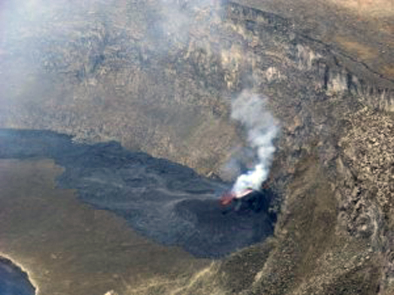 |
Figure 58. A new vent that had recently emerged on the E part of Nyiragongo's floor (terrace three) was first observed by OVG scientists on 1 March 2016. Photo courtesy of OVG. |
Observers during a 10-11 March field expedition noted that activity in the new vent consisted in pulsating lava fountains and Strombolian bursts which ejected material of a few tens of meters high. Lava flows from the new vent extended around the central pit on 11 March (figure 59). Activity in the lava lake was intense; lava fountains were active in the N and E parts of the lake. Both the lava lake and crater vent were producing gas emissions (figure 60).
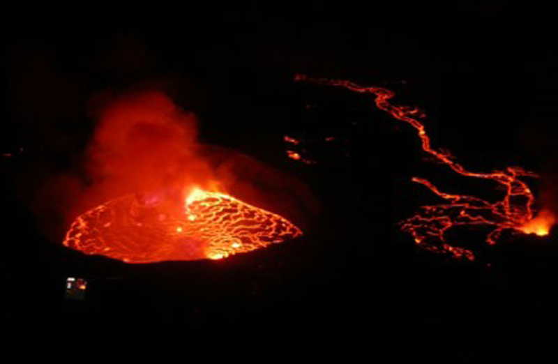 |
Figure 59. A view of the Nyiragongo summit crater on the night of 11-12 March 2016. The new vent on the E crater floor (right) produced lava flows that extended around the main lava lake. |
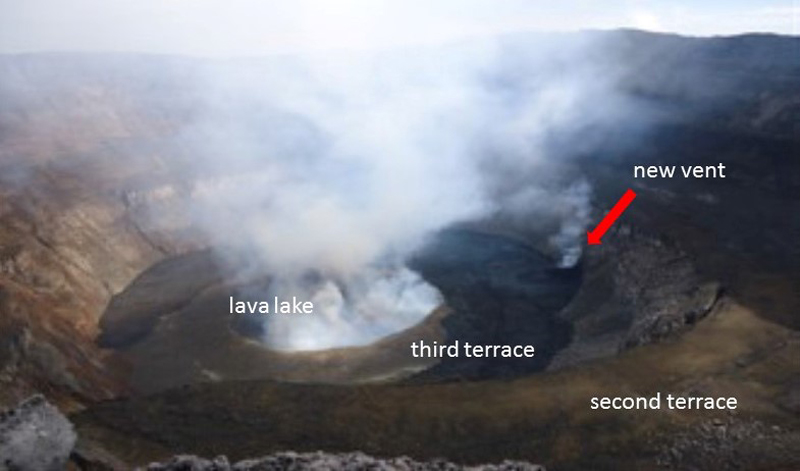 |
Figure 60. A daytime view of the Nyiragongo summit crater during 11-12 March 2016. Gas emissions from the new vent on the E crater floor (right) and from the lava lake were visible. The second and third terraces are visible in this wider view. |
On 26 March and 8 April 2016, the mainly effusive activity from the new vent continued with little change. Lava flows had surrounded the central pit (containing the main lava lake), covered most of the third terrace, and cascaded into the central vent at multiple locations.
A report from OVG on 12 April 2016 noted that activity had declined since 6 April 2016, and that the level of the lava lake had dropped. A report dated 17 April stated that some volcanic earthquakes had been located within 5 km E and 10-15 km N of the crater; continuous volcanic tremor was recorded during 0200-0400 on 17 April. In a photo dated 19 April the incandescent vent atop a spatter cone was visible. According to Volcano Discovery, local mountain guides reported that as of 30 May, no more lava flows were being produced from the vent, although bubbling lava was visible.
Ongoing activity through December 2016. Social media accounts and photos from a few tourist expeditions showed that the lava lake within the summit crater remained active during August-November 2016. Infrared data from MODIS instruments confirmed this persistent activity, with almost daily anomalies, through the end of December 2016.
Information from a weekly bulletin produced by the Goma Volcano Observatory, not available online, was reported by Radio Kivu. That report, for 27 December-2 January 2017, noted there was incandescence visible during 30-31 December, and that lava flows had overflowed the lake into the rest of the crater, accompanied by explosions and fountaining. A persistent gas plume can be seen during the day, which typically blows to the west.
Research on January 2002 eruption. In a recent article by Wauthier and others (2012), and summarized by Morton (2016), researchers reported finding evidence for linkage between the deadly January 2002 eruption (BGVN 26:12 and later) and a magnitude-6.2 earthquake eight months afterwards, centered 20 km S in the Lake Kivu region, partially destroying the town of Kalehe. Using satellite radar data (InSAR – Interferometric Synthetic Aperature Radar) to analyze ground deformation between the volcano and the lake before and after both the eruption and the earthquake, they inferred the formation of 20-km-long dike intrusion (figure 61, along the pink line between Nyiragongo and Lake Kivu).
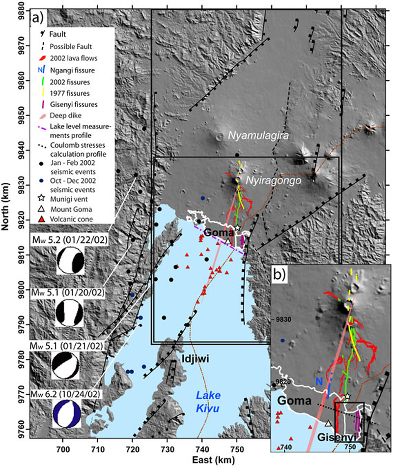 |
Figure 61. (a) Shaded relief topographic map of the Goma area and Lake Kivu. (b) Inset shows the region between Nyiragongo and Lake Kivu; the Goma and Gisenyi urban areas highlighted in white. From Wauthier and others (2012). |
References: Morton, M. C., 2016 (May/June), Double trouble: Volcanic eruption leads to strong earthquake eight months later, Earth, American Geosciences Institute, v.61, no. 5&6, p. 33 (www.earthmagazine.org).
Nelson, P., 2011 (28 February), Nyiragongo Crater: Journey to the Center of the World, boston.Com (URL: http://archive.boston.com/bigpicture/2011/02/nyiragongo_crater_journey_to_t.html). Photos by Olivier Grunewald.
Wauthier, C., Cayol, V., Kervyn, F., and d'Oreye, N., 2012 (May), Magma sources involved in the 2002 Nyiragongo eruption, as inferred from an InSAR analysis, Journal of Geophysical Research, Solid Earth, Geodesy and Gravity/Tectonophysics, v. 117, issue B5, 36 p.
Geological Summary. The Nyiragongo stratovolcano contained a lava lake in its deep summit crater that was active for half a century before draining catastrophically through its outer flanks in 1977. The steep slopes contrast to the low profile of its neighboring shield volcano, Nyamuragira. Benches in the steep-walled, 1.2-km-wide summit crater mark levels of former lava lakes, which have been observed since the late-19th century. Two older stratovolcanoes, Baruta and Shaheru, are partially overlapped by Nyiragongo on the north and south. About 100 cones are located primarily along radial fissures south of Shaheru, east of the summit, and along a NE-SW zone extending as far as Lake Kivu. Many cones are buried by voluminous lava flows that extend long distances down the flanks, which is characterized by the eruption of foiditic rocks. The extremely fluid 1977 lava flows caused many fatalities, as did lava flows that inundated portions of the major city of Goma in January 2002.
Information Contacts: Observatoire Volcanologique de Goma (Goma Volcano Observatory), Goma, North Kivu, DR Congo; Hawai'i Institute of Geophysics and Planetology (HIGP), MODVOLC Thermal Alerts System, School of Ocean and Earth Science and Technology (SOEST), Univ. of Hawai'i, 2525 Correa Road, Honolulu, HI 96822, USA (URL: http://modis.higp.hawaii.edu/); MIROVA - Middle InfraRed Observation of Volcanic Activity, A near real time volcanic hot-spot detection system based on the analysis of MODIS ( Moderate Resolution Imaging Spectroradiometer) data, a collaborative project between the Universities of Turin and Florence (Italy) (URL: http://www.mirovaweb.it/); Tom Pfeiffer, Volcano Discovery (URL: https://www.volcanodiscovery.com/nyiragongo/news); NASA Earth Observatory, EOS Project Science Office, NASA Goddard Space Flight Center, Goddard, Maryland, USA (URL: http://earthobservatory.nasa.gov/); Radio Kivu, Goma, North Kivu, DR Congo (URL: http://www.radiokivu1.org/page/article.php?action=articleread&tokena=1432).