Report on Semisopochnoi (United States) — February 2019
Bulletin of the Global Volcanism Network, vol. 44, no. 2 (February 2019)
Managing Editor: Edward Venzke.
Research and preparation by Robert Andrews.
Semisopochnoi (United States) Minor ash explosions during September and October 2018
Please cite this report as:
Global Volcanism Program, 2019. Report on Semisopochnoi (United States) (Venzke, E., ed.). Bulletin of the Global Volcanism Network, 44:2. Smithsonian Institution. https://doi.org/10.5479/si.GVP.BGVN201902-311060
Semisopochnoi
United States
51.93°N, 179.58°E; summit elev. 1221 m
All times are local (unless otherwise noted)
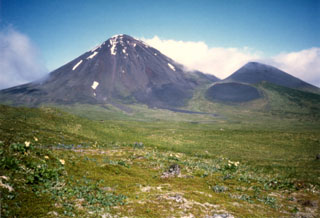
The remote Semisopochnoi comprises the uninhabited volcanic island of the same name, ~20 km in diameter, in the Rat Islands group of the western Aleutians (figure 1). Plumes had been reported several times in the 18th and 19th centuries, and most recently observed in April 1987 from Sugarloaf Peak (SEAN 12:04). The volcano is dominated by an 8-km diameter caldera that contains a small lake (Fenner Lake) and a number of post-caldera cones and craters. Monitoring is done by the Alaska Volcano Observatory (AVO) using an on-island seismic network along with satellite observations and lightning sensors. An infrasound array on Adak Island, about 200 km E, may detect explosive emissions with a 13 minute delay if atmospheric conditions permit.
On 16 September 2018 increased seismicity was detected at 0831, prompting AVO to raise the Aviation Color Code (ACC) to Yellow and Volcano Alert Level (VAL) to Advisory. Retrospective analysis of satellite data acquired on 10 September revealed small ash deposits on the N flank of Mount Cerberus, possibly associated with two bursts of tremor recorded on 8 September (figure 5). This new information, coupled with intensifying seismicity and a strong tremor signal recorded at 1249 on 17 September, resulted in AVO raising the ACC to Orange and the VAL to Watch. Seismicity remained elevated on 18 September with nearly constant tremor recorded by local sensors. At the same time, no ash emissions were observed in cloudy satellite images and no eruptive activity was recorded on regional pressure sensors at Adak.
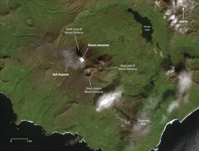 |
Figure 1. Minor ash deposits can be seen on the south and west flanks of the N cone of Mount Cerberus, Semisopochnoi Island, in this ESA Sentinel-2 image from 1200 on 10 September 2018. Also note probable minor steam emissions obscuring the crater of the N cone. Image courtesy of AVO. |
During 19-25 September 2018 seismicity remained elevated, alternating between periods of continuous and intermittent bursts of tremor. Tremor bursts at 1319 on 21 September and at 1034 on 22 September produced airwaves detected on a regional infrasound array on Adak Island; no ash emissions were identified above the low cloud deck in satellite data, and the infrasound detections likely reflected an atmospheric change instead of volcanic activity.
Seismicity remained elevated during 3-9 October 2018, with intermittent bursts of tremor. No volcanic activity was detected in infrasound or satellite data. On 11 October satellite data indicated partial erosion of a tephra cone in the crater of Cerberus's N cone. A crater lake about 90 m in diameter filled the vent. The data also suggested that the vent had not erupted since 1 October. Seismicity remained elevated and above background levels. The next day AVO lowered the Aviation Color Code to Yellow and the Volcano Alert Level to Advisory, noting the recent satellite data results and lack of tremor recorded during the previous week. AVO reported that unrest continued during 11-24 October.
An eruptive event began at 2047 on 25 October 2018, identified based on seismic data; strong volcanic tremor lasted about 20 minutes and was followed by 40 minutes of weak tremor pulses. A weak infrasound signal was detected by instruments on Adak Island. The Aviation Color Code was raised to Orange (the second highest level on a four-color scale) and Volcano Alert Level was raised to Watch (the second highest level on a four-level scale). A dense meteorological cloud deck prevented observations below 3 km, but a diffuse cloud was observed in satellite data rising briefly above the cloud deck, though it was unclear if it was related to eruptive activity. Tremor ended after the event, and seismicity returned to low levels.
Small explosions were detected by the seismic network at 2110 and 2246 on 26 October 2018, and 0057 and 0603 on 27 October. No ash clouds were identified in satellite data, but the volcano was obscured by high meteorological clouds. Additional small explosions were detected in seismic and infrasound data during 28-29 October; no ash clouds were observed in partly-cloudy-to-cloudy satellite images.
AVO reported on 31 October 2018 that unrest continued. Two small explosions were detected, one just before 0400 and the other around 1000. Satellite views were obscured by clouds at the time, and no ash clouds were observed. Unrest continued through 1 November, at which time the satellite link and the seismic line failed. On 21 November the ACC was lowered to Yellow and the VAL was lowered to Advisory.
Geological Summary. Semisopochnoi, the largest subaerial volcano of the western Aleutians, is 20 km wide at sea level and contains an 8-km-wide caldera. It formed as a result of collapse of a low-angle, dominantly basaltic volcano following the eruption of a large volume of dacitic pumice. The high point of the island is Anvil Peak, a double-peaked late-Pleistocene cone that forms much of the island's northern part. The three-peaked Mount Cerberus (renamed Mount Young in 2023) was constructed within the caldera during the Holocene. Each of the peaks contains a summit crater; lava flows on the N flank appear younger than those on the south side. Other post-caldera volcanoes include the symmetrical Sugarloaf Peak SSE of the caldera and Lakeshore Cone, a small cinder cone at the edge of Fenner Lake in the NE part of the caldera. Most documented eruptions have originated from Young, although Coats (1950) considered that both Sugarloaf and Lakeshore Cone could have been recently active.
Information Contacts: Alaska Volcano Observatory (AVO), a cooperative program of a) U.S. Geological Survey, 4200 University Drive, Anchorage, AK 99508-4667 USA (URL: https://avo.alaska.edu/), b) Geophysical Institute, University of Alaska, PO Box 757320, Fairbanks, AK 99775-7320, USA, and c) Alaska Division of Geological & Geophysical Surveys, 794 University Ave., Suite 200, Fairbanks, AK 99709, USA (URL: http://dggs.alaska.gov/).