Report on Reventador (Ecuador) — February 2020

Bulletin of the Global Volcanism Network, vol. 45, no. 2 (February 2020)
Managing Editor: Edward Venzke.
Edited by Kadie L. Bennis.
Reventador (Ecuador) Nearly daily ash emissions and frequent incandescent block avalanches August 2019-January 2020
Please cite this report as:
Global Volcanism Program, 2020. Report on Reventador (Ecuador) (Bennis, K.L., and Venzke, E., eds.). Bulletin of the Global Volcanism Network, 45:2. Smithsonian Institution. https://doi.org/10.5479/si.GVP.BGVN202002-352010
Reventador
Ecuador
0.077°S, 77.656°W; summit elev. 3562 m
All times are local (unless otherwise noted)
Reventador is an andesitic stratovolcano located in the Cordillera Real, Ecuador. Historical eruptions date back to the 16th century, consisting of lava flows and explosive events. The current eruptive activity has been ongoing since 2008 with previous activity including daily explosions with ash emissions, and incandescent block avalanches (BGVN 44:08). This report covers volcanism from August 2019 through January 2020 using information primarily from the Instituto Geofísico (IG-EPN), the Washington Volcano Ash Advisory Center (VAAC), and various infrared satellite data.
During August 2019 to January 2020, IG-EPN reported almost daily explosive eruptions and ash plumes. September had the highest average of explosive eruptions while January 2020 had the lowest (table 11). Ash plumes rose between a maximum of 1.2 to 2.5 km above the crater during this reporting period with the highest plume height recorded in December. The largest amount of SO2 gases produced was during the month of October with 502 tons/day. Frequently at night during this reporting period, crater incandescence was observed and was occasionally accompanied by incandescent block avalanches traveling as far as 900 m downslope from the summit of the volcano.
Table 11. Monthly summary of eruptive events recorded at Reventador from August 2019 through January 2020. Data courtesy of IG-EPN (August to January 2020 daily reports).
| Month | Average Number of Explosions | Max plume height above the crater | Max SO2 |
| Aug 2019 | 26 | 1.6 km | -- |
| Sep 2019 | 32 | 1.7 km | 428 tons/day |
| Oct 2019 | 29 | 1.3 km | 502 tons/day |
| Nov 2019 | 25 | 1.2 km | 432 tons/day |
| Dec 2019 | 25 | 2.5 km | 331 tons/day |
| Jan 2020 | 12 | 1.7 km | -- |
During the month of August 2019, between 11 and 45 explosions were recorded every day, frequently accompanied by gas-and-steam and ash emissions (figure 119); plumes rose more than 1 km above the crater on nine days. On 20 August the ash plume rose to a maximum 1.6 km above the crater. Summit incandescence was seen at night beginning on 10 August, continuing frequently throughout the rest of the reporting period. Incandescent block avalanches were reported intermittently beginning that same night through 26 January 2020, ejecting material between 300 to 900 m below the summit and moving on all sides of the volcano.
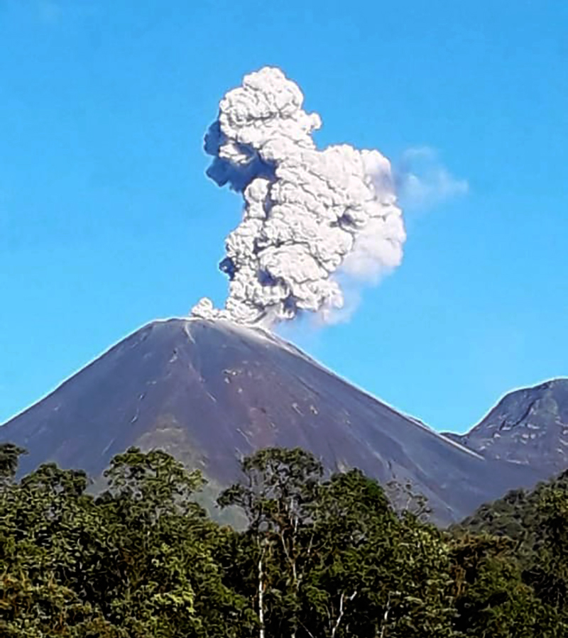 |
Figure 119. An ash plume rising from the summit of Reventador on 1 August 2019. Courtesy of Radio La Voz del Santuario. |
Throughout most of September 2019 gas-and-steam and ash emissions were observed almost daily, with plumes rising more than 1 km above the crater on 15 days, according to IG-EPN. On 30 September, the ash plume rose to a high of 1.7 km above the crater. Each day, between 18 and 72 explosions were reported, with the latter occurring on 19 September. At night, crater incandescence was commonly observed, sometimes accompanied by incandescent material rolling down every flank.
Elevated seismicity was reported during 8-15 October 2019 and almost daily gas-and-steam and ash emissions were present, ranging up to 1.3 km above the summit. Every day during this month, between 13 and 54 explosions were documented and crater incandescence was commonly observed at night. During November 2019, gas-and-steam and ash emissions rose greater than 1 km above the crater except for 10 days; no emissions were reported on 29 November. Daily explosions ranged up to 42, occasionally accompanied by crater incandescence and incandescent ejecta.
Washington VAAC notices were issued almost daily during December 2019, reporting ash plumes between 4.6 and 6 km altitude throughout the month and drifting in multiple directions. Each day produced 5-52 explosions, many of which were accompanied by incandescent blocks rolling down all sides of the volcano up to 900 m below the summit. IG-EPN reported on 11 December that a gas-and-steam and ash emission column rose to a maximum height of 2.5 km above the crater, drifting SW as was observed by satellite images and reported by the Washington VAAC.
Volcanism in January 2020 was relatively low compared to the other months of this reporting period. Explosions continued on a nearly daily basis early in the month, ranging from 20 to 51. During 5-7 January incandescent material ejected from the summit vent moved as block avalanches downslope and multiple gas-and-steam and ash plumes were produced (figures 120, 121, and 122). After 9 January the number of explosions decreased to 0-16 per day. Ash plumes rose between 4.6 and 5.8 km altitude, according to the Washington VAAC.
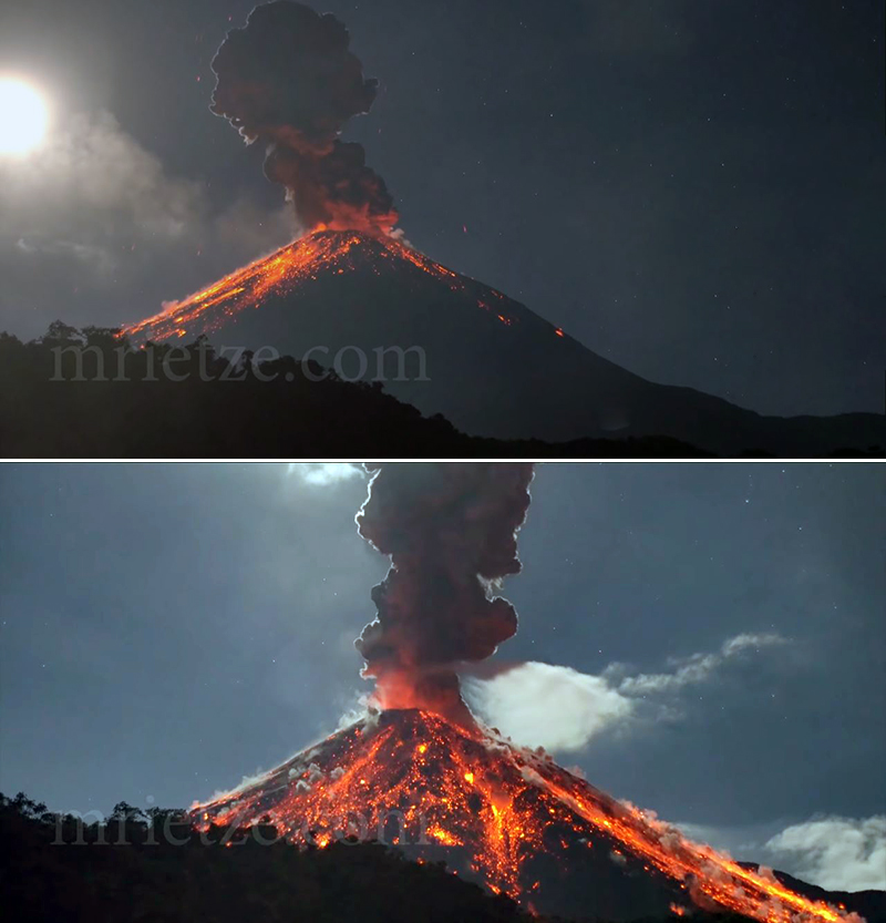 |
Figure 120. Night footage of activity on 5 (top) and 6 (bottom) January 2020 at the summit of Reventador, producing a dense, dark gray ash plume and ejecting incandescent material down multiple sides of the volcano. This activity is not uncommon during this reporting period. Courtesy of Martin Rietze, used with permission. |
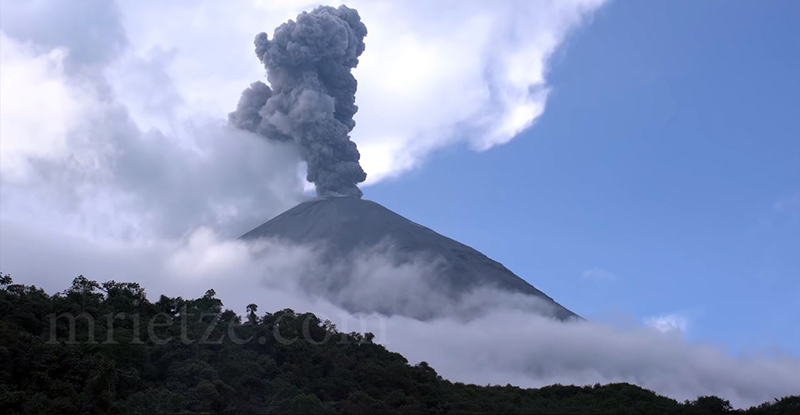 |
Figure 121. An explosion at Reventador on 7 January 2020, which produced a dense gray ash plume. Courtesy of Martin Rietze, used with permission. |
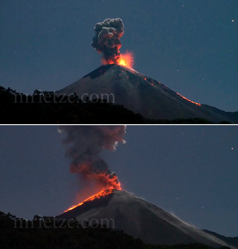 |
Figure 122. Night footage of the evolution of an eruption on 7 January 2020 at the summit of Reventador, which produced an ash plume and ejected incandescent material down multiple sides of the volcano. Courtesy of Martin Rietze, used with permission. |
MIROVA (Middle InfraRed Observation of Volcanic Activity) analysis of MODIS satellite data showed frequent and strong thermal anomalies within 5 km of the summit during 21 February 2019 through January 2020 (figure 123). In comparison, the MODVOLC algorithm reported 24 thermal alerts between August 2019 and January 2020 near the summit. Some thermal anomalies can be seen in Sentinel-2 thermal satellite imagery throughout this reporting period, even with the presence of meteorological clouds (figure 124). These thermal anomalies were accompanied by persistent gas-and-steam and ash plumes.
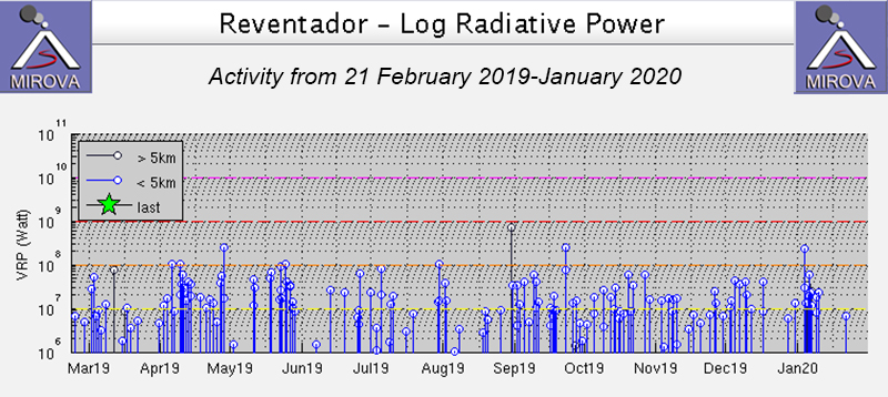 |
Figure 123. Thermal anomalies at Reventador persisted during 21 February 2019 through January 2020 as recorded by the MIROVA system (Log Radiative Power). Courtesy of MIROVA. |
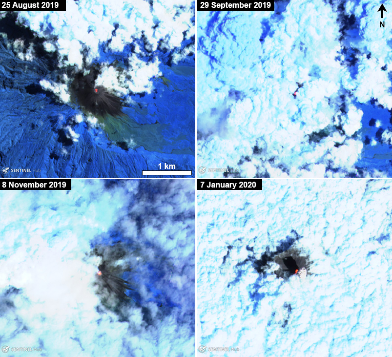 |
Figure 124. Sentinel-2 thermal satellite images of Reventador from August 2019 to January 2020 showing a thermal hotspot in the central summit crater summit. In the image on 7 January 2020, the thermal anomaly is accompanied by an ash plume. Courtesy of Sentinel Hub Playground. |
Geological Summary. Volcán El Reventador is the most frequently active of a chain of Ecuadorian volcanoes in the Cordillera Real, well east of the principal volcanic axis. The forested, dominantly andesitic stratovolcano has 4-km-wide avalanche scarp open to the E formed by edifice collapse. A young, unvegetated, cone rises from the amphitheater floor to a height comparable to the rim. It has been the source of numerous lava flows as well as explosive eruptions visible from Quito, about 90 km ESE. Frequent lahars in this region of heavy rainfall have left extensive deposits on the scarp slope. The largest recorded eruption took place in 2002, producing a 17-km-high eruption column, pyroclastic flows that traveled up to 8 km, and lava flows from summit and flank vents.
Information Contacts: Instituto Geofísico, Escuela Politécnica Nacional (IG-EPN), Casilla 17-01-2759, Quito, Ecuador (URL: http://www.igepn.edu.ec/); Washington Volcanic Ash Advisory Center (VAAC), Satellite Analysis Branch (SAB), NOAA/NESDIS OSPO, NOAA Science Center Room 401, 5200 Auth Rd, Camp Springs, MD 20746, USA (URL: www.ospo.noaa.gov/Products/atmosphere/vaac, archive at: http://www.ssd.noaa.gov/VAAC/archive.html); MIROVA (Middle InfraRed Observation of Volcanic Activity), a collaborative project between the Universities of Turin and Florence (Italy) supported by the Centre for Volcanic Risk of the Italian Civil Protection Department (URL: http://www.mirovaweb.it/); Hawai'i Institute of Geophysics and Planetology (HIGP) - MODVOLC Thermal Alerts System, School of Ocean and Earth Science and Technology (SOEST), Univ. of Hawai'i, 2525 Correa Road, Honolulu, HI 96822, USA (URL: http://modis.higp.hawaii.edu/); Sentinel Hub Playground (URL: https://www.sentinel-hub.com/explore/sentinel-playground); Radio La Voz del Santuario (URL: https://www.facebook.com/Radio-La-Voz-del-Santuario-126394484061111/, posted at: https://www.facebook.com/permalink.php?story_fbid=2630739100293291&id=126394484061111); Martin Rietze, Taubenstr. 1, D-82223 Eichenau, Germany (URL: https://mrietze.com/, https://www.youtube.com/channel/UC5LzAA_nyNWEUfpcUFOCpJw/videos).