Report on Nyiragongo (DR Congo) — December 2020

Bulletin of the Global Volcanism Network, vol. 45, no. 12 (December 2020)
Managing Editor: Edward Venzke.
Edited by Kadie L. Bennis. Research and preparation by Paul Berger.
Nyiragongo (DR Congo) Strong thermal anomalies and gas emission from lava lake through November 2020
Please cite this report as:
Global Volcanism Program, 2020. Report on Nyiragongo (DR Congo) (Bennis, K.L., and Venzke, E., eds.). Bulletin of the Global Volcanism Network, 45:12. Smithsonian Institution. https://doi.org/10.5479/si.GVP.BGVN202012-223030
Nyiragongo
DR Congo
1.52°S, 29.25°E; summit elev. 3470 m
All times are local (unless otherwise noted)
Nyiragongo is a stratovolcano in the DR Congo with a deep summit crater containing a lava lake and a small active cone. During June 2018-May 2020, the volcano exhibited strong thermal signals primarily due to the lava lake, along with incandescence, seismicity, and gas-and-steam plumes (BGVN 44:05, 44:12, 45:06). The volcano is monitored by the Observatoire Volcanologique de Goma (OVG). This report summarizes activity during June-November 2020, based on satellite data.
Infrared MODIS satellite data showed almost daily strong thermal activity during June-November 2020 from MIROVA (Middle InfraRed Observation of Volcanic Activity), consistent with a large lava lake. Numerous hotspots were also identified every month by MODVOLC. Although clouds frequently obscured the view from space, a clear Sentinel-2 image in early June showed a gas-and-steam plume as well as a strong thermal anomaly (figure 76).
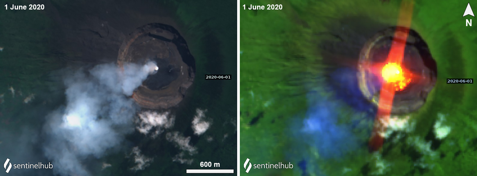 |
Figure 76. Sentinel-2 satellite imagery of Nyiragongo on 1 June 2020. A gas-and-steam is visible in the natural color image (bands 4, 3, 2) rising from a pit in the center of the crater (left), while the false color image (bands 12, 11, 4) reveals a strong thermal signal from a lava lake (right). Courtesy of Sentinel Hub Playground. |
During the first half of June 2020, OVG reported that SO2 levels had decreased compared to levels in May (7,000 tons/day); during the second half of June the SO2 flux began to increase again. High levels of sulfur dioxide were recorded almost every day in the region above or near the volcano by the TROPOspheric Monitoring Instrument (TROPOMI) aboard the Copernicus Sentinel-5 Precursor satellite (figure 77). According to OVG, SO2 flux ranged from 819-5,819 tons/day during June. The number of days with a high SO2 flux decreased somewhat in July and August, with high levels recorded during about half of the days. The volume of SO2 emissions slightly increased in early July, based on data from the DOAS station in Rusayo, measuring 6,787 tons/day on 8 July (the highest value reported during this reporting period), and then declined to 509 tons/day by 20 July. The SO2 flux continued to gradually decline, with high values of 5,153 tons/day in August and 4,468 tons/day in September. The number of days with high SO2 decreased further in September and October but returned to about half of the days in November.
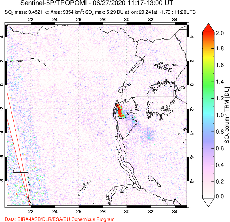 |
Figure 77. TROPOMI image of SO2 plume on 27 June 2020 in the Nyiragongo-Nyamulagira area. The plume drifted SSE. Courtesy of NASA Global Sulfur Dioxide Monitoring Page. |
During 12-13 July a multidisciplinary team of OVG scientists visited the volcano to take measurements of the crater using a TCRM1102 Plus2 laser. They noted that the crater had expanded by 47.3 mm in the SW area, due to the rise in the lava lake level since early 2020. The OVG team took photos of the small cone in the lava lake that has been active since 2014, recently characterized by white gas-and-steam emissions (figure 78). OVG noted that the active lava lake had subsided roughly 20 m (figure78).
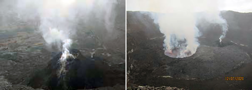 |
Figure 78. Photos (color corrected) of the crater at Nyiragongo showing the small active cone generating gas-and-steam emissions (left) and the active lava lake also characterized by white gas-and-steam emissions on 12 July 2020 (right). Courtesy of OVG (Rapport OVG Juillet 2020). |
Geological Summary. The Nyiragongo stratovolcano contained a lava lake in its deep summit crater that was active for half a century before draining catastrophically through its outer flanks in 1977. The steep slopes contrast to the low profile of its neighboring shield volcano, Nyamuragira. Benches in the steep-walled, 1.2-km-wide summit crater mark levels of former lava lakes, which have been observed since the late-19th century. Two older stratovolcanoes, Baruta and Shaheru, are partially overlapped by Nyiragongo on the north and south. About 100 cones are located primarily along radial fissures south of Shaheru, east of the summit, and along a NE-SW zone extending as far as Lake Kivu. Many cones are buried by voluminous lava flows that extend long distances down the flanks, which is characterized by the eruption of foiditic rocks. The extremely fluid 1977 lava flows caused many fatalities, as did lava flows that inundated portions of the major city of Goma in January 2002.
Information Contacts: Observatoire Volcanologique de Goma (OVG), Departement de Geophysique, Centre de Recherche en Sciences Naturelles, Lwiro, D.S. Bukavu, DR Congo; MIROVA (Middle InfraRed Observation of Volcanic Activity), a collaborative project between the Universities of Turin and Florence (Italy) supported by the Centre for Volcanic Risk of the Italian Civil Protection Department (URL: http://www.mirovaweb.it/); Hawai'i Institute of Geophysics and Planetology (HIGP) - MODVOLC Thermal Alerts System, School of Ocean and Earth Science and Technology (SOEST), Univ. of Hawai'i, 2525 Correa Road, Honolulu, HI 96822, USA (URL: http://modis.higp.hawaii.edu/); Sentinel Hub Playground (URL: https://www.sentinel-hub.com/explore/sentinel-playground); NASA Global Sulfur Dioxide Monitoring Page, Atmospheric Chemistry and Dynamics Laboratory, NASA Goddard Space Flight Center (NASA/GSFC), 8800 Greenbelt Road, Goddard, Maryland, USA (URL: https://so2.gsfc.nasa.gov/).