Report on Reventador (Ecuador) — February 2021

Bulletin of the Global Volcanism Network, vol. 46, no. 2 (February 2021)
Managing Editor: Edward Venzke.
Edited by A. Elizabeth Crafford.
Reventador (Ecuador) Continued ash emissions and incandescent blocks avalanches; new dome and lava flow emerge in August 2020
Please cite this report as:
Global Volcanism Program, 2021. Report on Reventador (Ecuador) (Crafford, A.E., and Venzke, E., eds.). Bulletin of the Global Volcanism Network, 46:2. Smithsonian Institution. https://doi.org/10.5479/si.GVP.BGVN202102-352010
Reventador
Ecuador
0.077°S, 77.656°W; summit elev. 3562 m
All times are local (unless otherwise noted)
The andesitic Volcán El Reventador lies almost 100 km E of the main axis of active volcanoes in Ecuador and has historical eruptions with numerous lava flows and explosive events going back to the 16th century. An eruption in November 2002 generated a 17-km-high eruption cloud, pyroclastic flows that traveled 8 km, and multiple lava flows. Eruptive activity has been continuous since 2008. Daily explosions with ash emissions and ejecta of incandescent blocks rolling hundreds of meters down the flanks have been typical for many years. Similar activity continued during August 2020-January 2021, the period covered in this report, with information provided by Ecuador's Instituto Geofisico (IG-EPN), the Washington Volcano Ash Advisory Center (VAAC), and infrared satellite data.
Near-daily emissions of gas and ash often rose 500-1,000 m above the summit and drifted mostly in a westerly direction throughout August 2020-January 2021. Incandescence at night was produced by explosions of ejecta that sent blocks rolling hundreds of meters down the flanks of the pyroclastic cone inside the summit caldera. IG-EPN reported the presence of a new dome inside the crater in early August. A small lava flow about 400 m long persisted on the NE flank through at least the end of 2020; another flow was observed on the N flank in January. Small pyroclastic flows were reported a few times, and ashfall occurred in the San Rafael region (10 km SSE) at the end of October. After a relatively quiet June 2020, thermal activity increased to moderate levels and remained there throughout the period (figure 132).
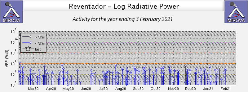 |
Figure 132. Thermal activity at Reventador was consistent at moderate to high levels from late June 2020 through January 2021, according to this MIROVA project graph of log radiative power at the volcano. Courtesy of MIROVA. |
Gas and ash emissions rose 500-1,000 m above the summit almost every day during August 2020 (figure 133). Incandescence and explosions at the summit crater, visible at night, were accompanied many nights by incandescent blocks that rolled 500-700 m down various flanks. The Washington VAAC issued 1-4 alerts most days, reporting ash observed in satellite data that rose 700-1,400 m above the summit. Drift directions were generally NW, W, or SW. IG reported a pyroclastic flow on the NE flank on 4 August, and a new 200-m-long lava flow near the summit on the NE flank was seen on 10 August (figure 134). By 19 August the lava flow had reached 350 m long; it remained active for the rest of the month but didn’t increase in length. Based on the analysis of webcam photographs and infrared images, they confirmed the growth of a new dome on 17 August (figure 135). MODVOLC thermal alerts were recorded on 3 and 11 August.
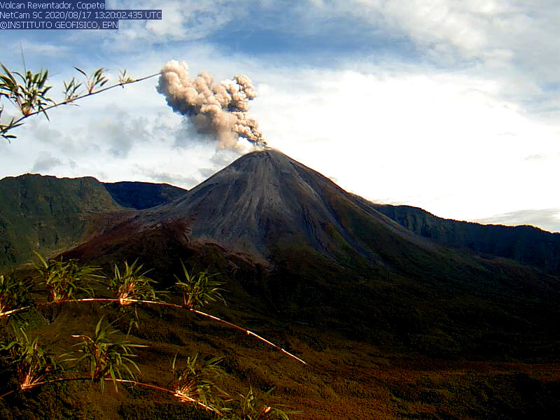 |
Figure 133. Gas and ash rose 500-1,000 m above the summit of Reventador most days during August 2020, as seen here on 17 August. Courtesy of IG-EPN (INFORME DIARIO DEL ESTADO DEL VOLCÁN REVENTADOR No. 2020-231, LUNES, 17 AGOSTO 2020). |
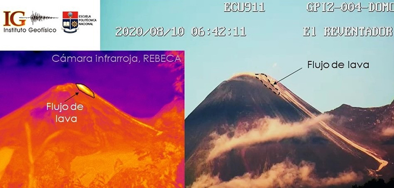 |
Figure 134. IG-EPN reported a new lava flow on the NE flank of Reventador on 10 August 2020. It was about 400 m long and persisted through the end of 2020. Courtesy of IG-EPN (INFORME DIARIO DEL ESTADO DEL VOLCÁN REVENTADOR No. 2020-224, LUNES, 10 AGOSTO 2020). |
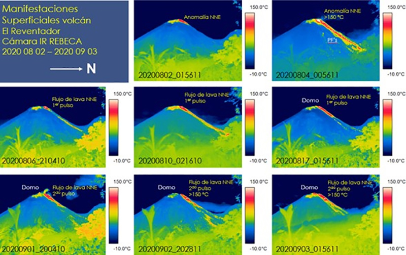 |
Figure 135. Infrared images show volcanic activity at Reventador during August 2020, including a pyroclastic flow on 4 August (top right), a lava flow on 6 August (middle left), and a lava dome on 17 August (middle right and bottom row). Courtesy of IG-EPN (Prepared by Cámar IR, S Vallejo; Informe Especial del Volcán El Reventador No. 2-2020). |
Incandescence from summit explosions was visible most nights in September 2020; explosions sent glowing blocks 500-800 m down multiple flanks on many nights. The lava flow on the NE flank remained active, growing slightly from 350 to 400 m in length. Three or four VAAC alerts were issued each day for ash plumes that rose usually 700-1,400 m above the summit and drifted NW. IG webcams captured images of ash emissions rising 600-900 m above the summit on most days; a few exceeded 1,000 m in height. IG reported pyroclastic flows on the N flank on 3 and 4 September, and on the W flank on 6 September. Pyroclastic deposits were observed on the E flank of the cone on 26 September, and the webcams captured a pyroclastic flow in the early morning of 29 September along the WSW flank that reached 600 m from the summit (figure 136). All of the pyroclastic flows remained inside the summit caldera. MODVOLC thermal alerts were recorded on 11, 12, and 20 September.
 |
Figure 136. A pyroclastic flow was visible on the WSW flank of Reventador on 29 September 2020 along with an ash plume that rose hundreds of meters above the summit. Courtesy of IG-EPN (IGAlInstante Informativo VOLCÁN REVENTADOR No. 005, MARTES, 29 SEPTIEMBRE 2020). |
The 400- to 450-m-long lava flow that first emerged on the NE flank in early August remained active, as seen in thermal imagery, throughout October 2020 (figure 137). Emissions of gas and ash continued rising daily 500-1,000 m above the summit and drifting in multiple different directions. Multiple VAAC reports were issued on most days; the plumes increased in height and frequency during the second half of the month, reaching 1,400 m above the summit. Incandescent blocks rolled 500-800 m down the flanks on most nights. MODVOLC thermal alerts were issued on five days during the month, on 2, 11, 14, 25, and 27 October; five alerts were issued on 25 October. Occasional pyroclastic flows were recorded on the N flank on 21 October. Fine-grained ashfall was reported in the San Rafael region (on the border between the Napo and Sucumbios provinces, 10 km ESE) on 28 and 30 October (figure 138).
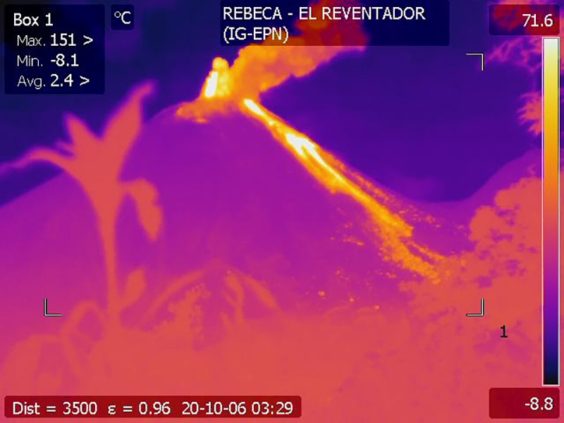 |
Figure 137. The lava flow on the NE flank of Reventador was about 450 m long and active throughout October 2020. In this 6 October 2020 infrared image incandescent ejecta rose from the summit and the lava flow was visible on the NE flank. Courtesy of IG-EPN (INFORME DIARIO DEL ESTADO DEL VOLCÁN REVENTADOR No. 2020-281, MARTES, 6 OCTUBRE 2020). |
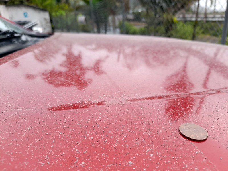 |
Figure 138. IGEPN official S. Vallejo reported ashfall on a vehicle in the San Rafael region on the border between the Napo and Sucumbios provinces, 10 km ESE of Reventador on 28 and 30 October. US penny for scale. Photo by S. Vallejo, courtesy of IG-EPN (IGAlInstante Informativo VOLCÁN REVENTADOR No. 007, VIERNES, 30 OCTUBRE 2020). |
Steam, gas, and ash emissions continued throughout November 2020, with many plumes rising 800-1,000 m above the summit and drifting NW (figure 139). Multiple daily VAAC reports indicated plumes visible in satellite imagery 1,000-1,400 m above the summit on most days. The lava flow remained active on the NE flank with thermal imagery indicating a strong heat signal 400-450 m from the summit. The explosions that produced the incandescent blocks were strongest during 5-7 November when the blocks rolled as far as 1,000 m from the summit. Cloudy weather and rain obscured views of activity at the end of the month, and a lahar was measured by seismic instruments on 27 November, but no damage was reported. MODVOLC alerts were issued on 3, 10, 26, and 30 November. Cloudy weather during the first week of December prevented many observations, but clearer skies later in the month indicated ongoing activity that included gas and ash emissions rising about 1,000 m and drifting NW; incandescent blocks rolled 500 m down the flanks following explosions inside the crater. Only a single MODVOLC alert was issued on 25 December. The 450-m-long lava flow on the NE flank remained active.
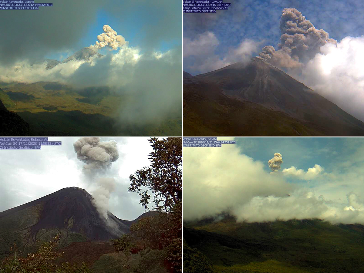 |
Figure 139. Many ash plumes at Reventador rose 800-1,000 m above the summit during November 2020. They were visible on some days when the mountain was not; clear days revealed blocks rolling down the NE flank and raising ash clouds as they rolled (bottom left). Courtesy of IG-EPN (INFORME DIARIO DEL ESTADO DEL VOLCÁN REVENTADOR Nos. 2020-312, 2020-315, 2020-323, and 2020-327). |
A new pulse of lava was first reported from a vent on the N flank on 10 January 2021 and remained active for the rest of the month. That same day incandescent blocks traveled 700 m down the NE flank. Pyroclastic flows were observed on the night of 14 January on the N flank. Satellite imagery on 16 January showed multiple areas of thermal activity at the summit and on the NNE flank (figure 140). On 21 January the ejecta from the explosions rose a hundred meters or more into the air over the pyroclastic cone in addition to traveling several hundred meters down the NE flank (figure 141). MODVOLC thermal alerts were issued on 4, 13, and 31 January.
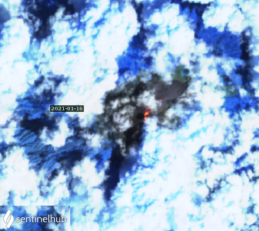 |
Figure 140. Sentinel-2 satellite imagery of Reventador on 16 January 2021 indicated strong thermal anomalies at the summit and on the NE flank, even through the frequently dense cloud cover. Courtesy of Sentinel Hub Playground. |
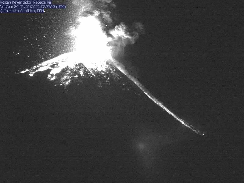 |
Figure 141. On 21 January 2021 the ejecta from explosions at Reventador could be seen rising a hundred meters or more over the pyroclastic cone in addition to traveling several hundred meters down the NE flank. Courtesy of IG-EPN (INFORME DIARIO DEL VOLCAN REVENTADOR No. 2021-021, Quito, jueves 21 de enero de 2021). |
Geological Summary. Volcán El Reventador is the most frequently active of a chain of Ecuadorian volcanoes in the Cordillera Real, well east of the principal volcanic axis. The forested, dominantly andesitic stratovolcano has 4-km-wide avalanche scarp open to the E formed by edifice collapse. A young, unvegetated, cone rises from the amphitheater floor to a height comparable to the rim. It has been the source of numerous lava flows as well as explosive eruptions visible from Quito, about 90 km ESE. Frequent lahars in this region of heavy rainfall have left extensive deposits on the scarp slope. The largest recorded eruption took place in 2002, producing a 17-km-high eruption column, pyroclastic flows that traveled up to 8 km, and lava flows from summit and flank vents.
Information Contacts: Instituto Geofísico, Escuela Politécnica Nacional (IG-EPN), Casilla 17-01-2759, Quito, Ecuador (URL: http://www.igepn.edu.ec/); MIROVA (Middle InfraRed Observation of Volcanic Activity), a collaborative project between the Universities of Turin and Florence (Italy) supported by the Centre for Volcanic Risk of the Italian Civil Protection Department (URL: http://www.mirovaweb.it/); Hawai'i Institute of Geophysics and Planetology (HIGP) - MODVOLC Thermal Alerts System, School of Ocean and Earth Science and Technology (SOEST), Univ. of Hawai'i, 2525 Correa Road, Honolulu, HI 96822, USA (URL: http://modis.higp.hawaii.edu/); Sentinel Hub Playground (URL: https://www.sentinel-hub.com/explore/sentinel-playground).