Report on Reventador (Ecuador) — August 2021

Bulletin of the Global Volcanism Network, vol. 46, no. 8 (August 2021)
Managing Editor: Edward Venzke.
Edited by Kadie L. Bennis.
Reventador (Ecuador) Ash explosions, lava flows, and block avalanches continue during February-July 2021
Please cite this report as:
Global Volcanism Program, 2021. Report on Reventador (Ecuador) (Bennis, K.L., and Venzke, E., eds.). Bulletin of the Global Volcanism Network, 46:8. Smithsonian Institution. https://doi.org/10.5479/si.GVP.BGVN202108-352010
Reventador
Ecuador
0.077°S, 77.656°W; summit elev. 3562 m
All times are local (unless otherwise noted)
Volcán El Reventador is located 100 km E of the main axis of active volcanoes in Ecuador and has had historical eruptions dating back to the 16th century, characterized by explosive events and lava flows. The most recent eruption began in 2008 and has recently consisted of ash emissions, incandescent block avalanches, a new lava dome, and lava flows (BGVN 46:02). This report updates information from February through July 2021 and is characterized by daily explosions, ash plumes, incandescent block avalanches, lava flows, and occasional pyroclastic flows and lahars, based on daily reports from Ecuador's Instituto Geofisico (IG-EPN), the Washington Volcano Ash Advisory Center (VAAC), and infrared satellite data.
During February to July 2021, IG-EPN reported daily explosions, gas-and-steam and ash plumes, and frequent crater incandescence, often accompanied by incandescent block avalanches and lava flows. The highest average number of explosions per day was 73 in March, followed by 65 in February (table 13). During May-June the average number of daily explosions had declined to 34 and 33, respectively. Ash plumes rose to a maximum height of 2.3 km above the crater on 11 June. At night and early morning, frequent crater incandescence was visible, occasionally accompanied by lava flows generally on the eastern flanks and incandescent block avalanches traveling as far as 900 m from the summit. Seismicity, which was noted throughout the reporting period, was characterized by harmonic tremor events, signals indicating emissions, few volcano-tectonic earthquakes, and dominantly long-period (LP) earthquakes.
Table 13. Monthly summary of explosions and plume heights recorded at Reventador from February through July 2021. Data courtesy of IG-EPN (February to July 2021 daily reports).
| Month | Average Number of Explosions per day | Max plume height above the crater (km) |
| Feb 2021 | 65 | 1.4 |
| Mar 2021 | 73 | 1.5 |
| Apr 2021 | 57 | 1.3 |
| May 2021 | 34 | 1.4 |
| Jun 2021 | 33 | 2.3 |
| Jul 2021 | 52 | 1.6 |
Activity at the summit was consistent during February and March 2021. There were 25-121 daily explosive events during these two months, generating gas-and-steam and ash plumes to 400-1,500 m above the crater that drifted in multiple directions (figure 142). At night, crater incandescence and incandescent block avalanches were visible on all flanks, though primarily on the NE and S flanks traveling 500-800 m below the crater (figure 143), though it was not uncommon for weather to prevent clear views of the summit. Two lava flows were reported moving down the N and NE flanks.
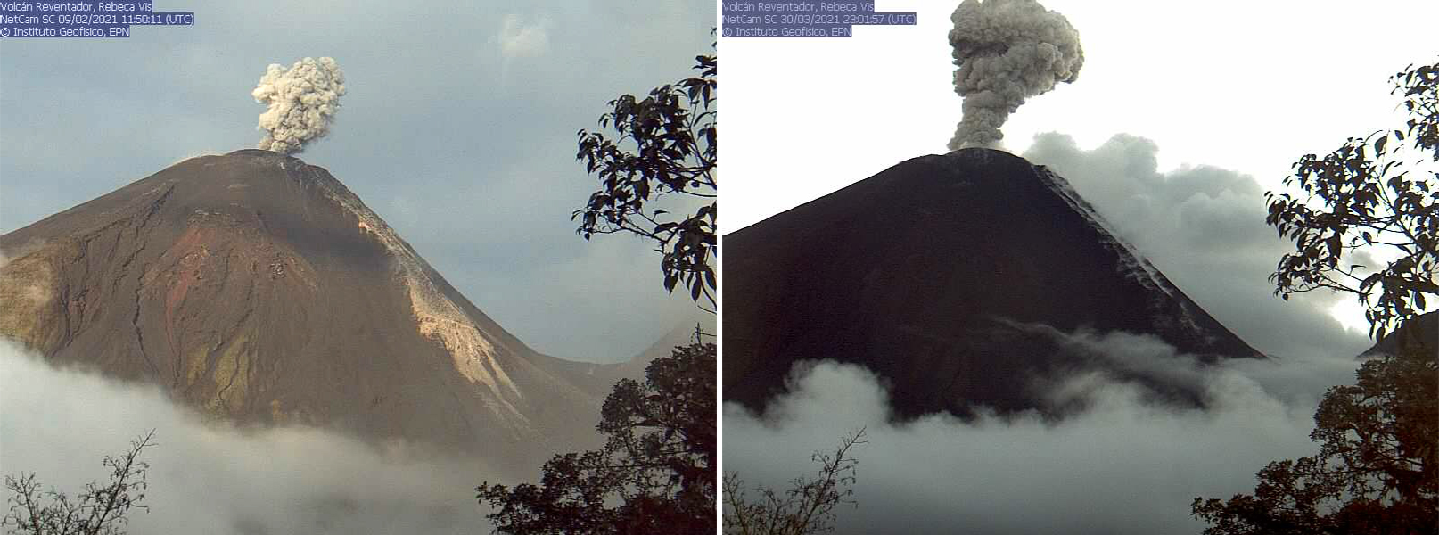 |
Figure 142. Webcam (Rebeca) images of two gray ash plumes rising from Reventador on 9 February (left) and 30 March (right) 2021. The NE flank is visible on the right side of the volcano, highlighted by recent block avalanches and active lava flows (light brown) in the February image. On 30 March white gas-and-steam emissions can be seen on the NE flank. Courtesy of IG-EPN (INFORME DIARIO DEL VOLCAN REVENTADOR No. 2021-040, 09 de febrero de 2021 and No. 2021-090, 31 de marzo de 2021). |
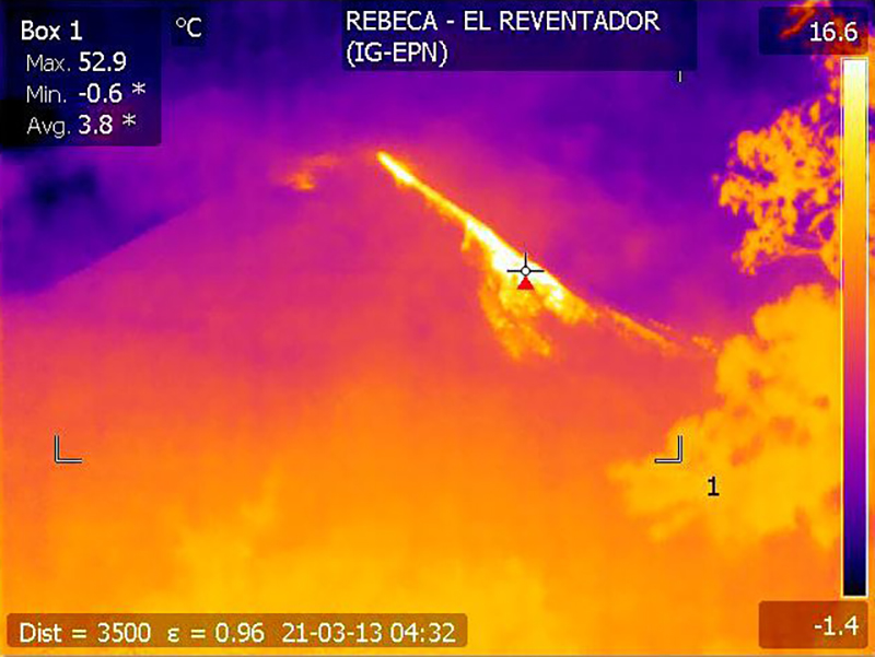 |
Figure 143. Webcam (Rebeca) infrared image of Reventador’s NE flank showing the active incandescent block avalanches (bright yellow-orange) on 13 March 2021. Courtesy of IG-EPN (INFORME DIARIO DEL VOLCAN REVENTADOR No. 2021-072, 13 de marzo de 2021). |
During April and May, explosions remained frequent, with 4-105 per day; ash plumes rose 400-1,400 m above the crater (figure 144) and drifted in different directions, though cloudy weather often prevented clear observations. Nighttime crater incandescence was reported during clear weather, accompanied by gas-and-steam emissions and incandescent blocks of material rolling down all flanks as far as 800 m, though the NE and S flanks were dominantly affected. On 21 April an infrared webcam recorded low temperatures of the lava flow on the NE flank, which IG-EPN indicated was no longer active. Small pyroclastic flows descending the SW flank for 600-700 m were noted on 23 and 26-27 April, but none reached the base of the cone. During 4-6 May a pyroclastic flow was reported 400 m down the SW flank, (figure 145). According to an infrared webcam, a lava flow on the NE flank became active again on 10 May; by 22 May, two flows were reported descending the NE and SE flanks (figure 144). Some blocks of material from the front of the lava flow traveled 800 m below the summit. IG-EPN reported that some inflation was noted on the N summit on 13 May, which continued into the following month. On 17 May around 1600 lahars were detected in the upper part of the Reventador River on the N drainages due to heavy rain. By 25 May the number of lahars had decreased and as a result, the seismic stations recorded consistent seismic signals starting around 0741 and continuing throughout the day.
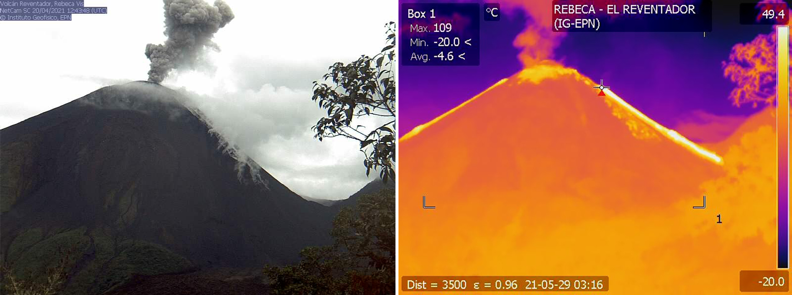 |
Figure 144. Webcam (Rebeca) images showing an ash plume rising above Reventador on 20 April 2021 (left) accompanied by white gas-and-steam emissions and block avalanches rolling down the NE flank. An infrared image (right) shows the two active lava flows (bright yellow) descending the NE and SE flanks on 29 May 2021. Courtesy of IG-EPN (INFORME DIARIO DEL VOLCAN REVENTADOR No. 2021-110, 20 de abril de 2021 and No. 2021-150, 29 de mayo de 2021). |
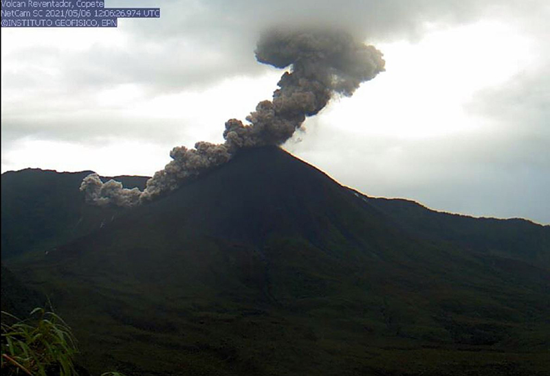 |
Figure 145. Webcam (Copete) image of a dense gray ash plume rising from Reventador, accompanied by a pyroclastic flow descending the SW flank at 0706 on 6 May 2021. Courtesy of IG-EPN (INFORME DIARIO DEL VOLCAN REVENTADOR No. 2021-126, 06 de mayo de 2021). |
Persistent explosions and ash plumes were reported during June and July, with 3-87 daily events that rose 300-2,300 m above the crater (figure 146). The plumes drifted primarily W, N, NW, NE, and SW. At night and during the early morning, incandescence was observed on the upper part of the flanks while the two lava flows continued to descend the NE and S flanks (figure 146). Incandescent blocks of material rolled down the NE, S, and SE flanks as far as 800 m below the summit. On 7 June during 1200 and 1300 a lahar was reported on the SE flank.
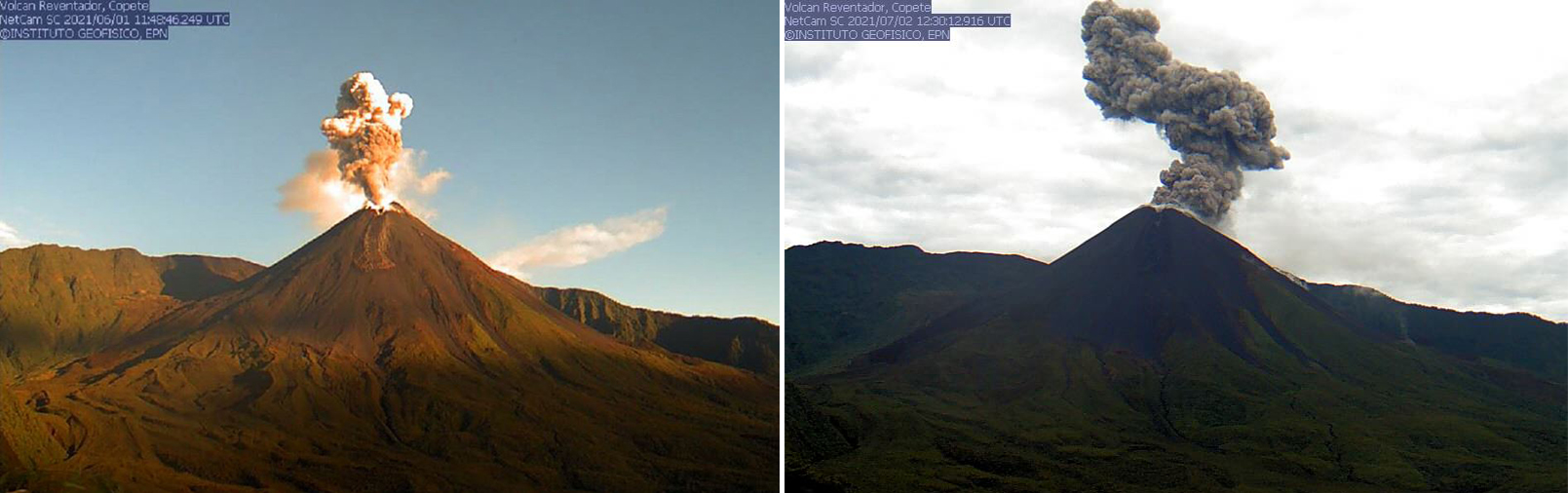 |
Figure 146. Webcam (Copete) images showing dense ash plumes rising from Reventador on 1 June (left) and 2 July (right) 2021. The ash plume from 1 June is accompanied by a lava flow on the SE flank. Courtesy of IG-EPN (INFORME DIARIO DEL VOLCAN REVENTADOR No. 2021-153, 01 de junio de 2021 and No. 2021-184, 02 de julio de 2021). |
MIROVA (Middle InfraRed Observation of Volcanic Activity) analysis of MODIS satellite data showed intermittent thermal anomalies of moderate-to-high intensity during February through July 2021 (figure 147), which reflected the active lava flows and incandescent block avalanches occurring throughout that time. In comparison, the MODVOLC thermal algorithm identified nine thermal alerts between February and July on 9 and 14 February, 20 March, 12 May, 10 and 22 June, and 28 July. Some incandescent avalanches were visible in Sentinel-2 infrared satellite imagery, though clouds often obscured the view of the summit (figure 148). These avalanches were observed descending the NE flanks.
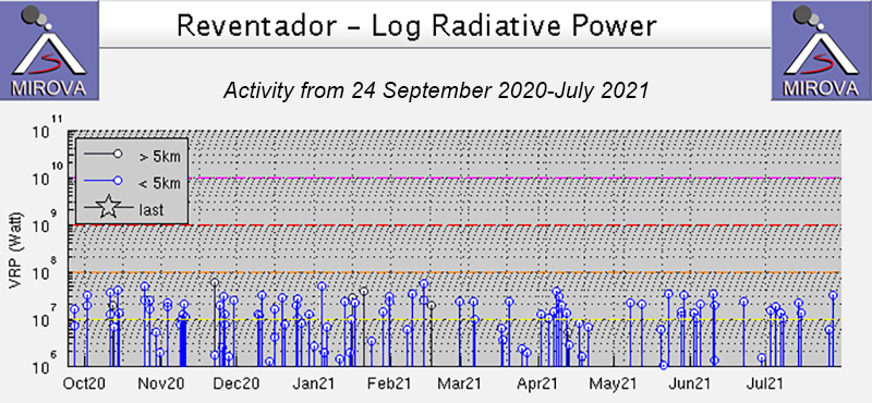 |
Figure 147. Intermittent thermal activity was detected at Reventador at moderate to high levels during February through July 2021, based on the MIROVA graph (Log Radiative Power). Courtesy of MIROVA. |
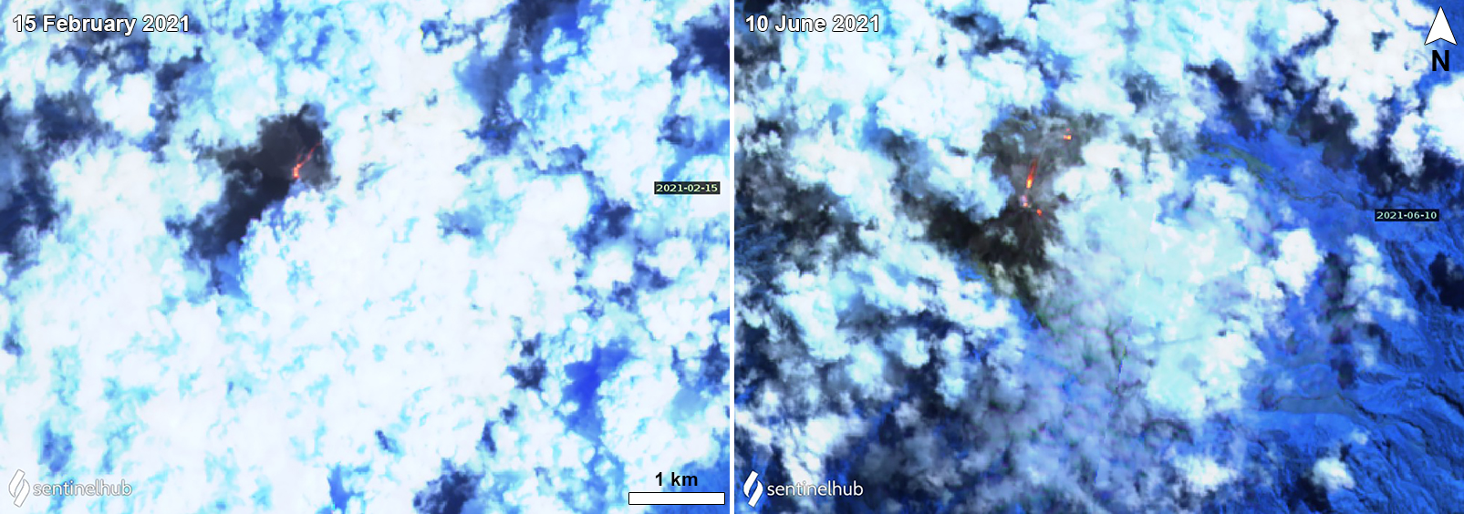 |
Figure 148. Sentinel-2 infrared satellite images of Reventador on 15 February 2021 (left) and 10 June (right) showed strong incandescent block avalanches descending the NE flanks, even through frequently dense cloud cover. Images with “Atmospheric penetration” (bands 12, 11, 8A) rendering. Courtesy of Sentinel Hub Playground. |
Geological Summary. Volcán El Reventador is the most frequently active of a chain of Ecuadorian volcanoes in the Cordillera Real, well east of the principal volcanic axis. The forested, dominantly andesitic stratovolcano has 4-km-wide avalanche scarp open to the E formed by edifice collapse. A young, unvegetated, cone rises from the amphitheater floor to a height comparable to the rim. It has been the source of numerous lava flows as well as explosive eruptions visible from Quito, about 90 km ESE. Frequent lahars in this region of heavy rainfall have left extensive deposits on the scarp slope. The largest recorded eruption took place in 2002, producing a 17-km-high eruption column, pyroclastic flows that traveled up to 8 km, and lava flows from summit and flank vents.
Information Contacts: Instituto Geofísico, Escuela Politécnica Nacional (IG-EPN), Casilla 17-01-2759, Quito, Ecuador (URL: http://www.igepn.edu.ec/); Washington Volcanic Ash Advisory Center (VAAC), Satellite Analysis Branch (SAB), NOAA/NESDIS OSPO, NOAA Science Center Room 401, 5200 Auth Rd, Camp Springs, MD 20746, USA (URL: www.ospo.noaa.gov/Products/atmosphere/vaac, archive at: http://www.ssd.noaa.gov/VAAC/archive.html); MIROVA (Middle InfraRed Observation of Volcanic Activity), a collaborative project between the Universities of Turin and Florence (Italy) supported by the Centre for Volcanic Risk of the Italian Civil Protection Department (URL: http://www.mirovaweb.it/); Hawai'i Institute of Geophysics and Planetology (HIGP) - MODVOLC Thermal Alerts System, School of Ocean and Earth Science and Technology (SOEST), Univ. of Hawai'i, 2525 Correa Road, Honolulu, HI 96822, USA (URL: http://modis.higp.hawaii.edu/); Sentinel Hub Playground (URL: https://www.sentinel-hub.com/explore/sentinel-playground).