Report on Semeru (Indonesia) — January 2022

Bulletin of the Global Volcanism Network, vol. 47, no. 1 (January 2022)
Managing Editor: Edward Venzke.
Edited by A. Elizabeth Crafford.
Semeru (Indonesia) Pyroclastic flows and lahars from dome collapse on 4 December 2021 destroyed multiple communities and caused fatalities
Please cite this report as:
Global Volcanism Program, 2022. Report on Semeru (Indonesia) (Crafford, A.E., and Venzke, E., eds.). Bulletin of the Global Volcanism Network, 47:1. Smithsonian Institution. https://doi.org/10.5479/si.GVP.BGVN202201-263300
Semeru
Indonesia
8.108°S, 112.922°E; summit elev. 3657 m
All times are local (unless otherwise noted)
Hundreds of eruptive events in the 19th and 20th centuries, including nearly continuous activity since 1967, mark Semeru as one of the world’s more active and hazardous volcanoes. Activity at Semeru, located on the eastern half of Java, Indonesia, has included lava flows, Vulcanian and Strombolian explosions, pyroclastic flows, lava domes, and lahars (mudflows); fatalities and serious injuries have occurred in 1981, 1994, 1997, and 2000. The current eruption, ongoing since 2014, produced a major ash plume in early December 2021 that caused ashfall, pyroclastic flows, and lahars that damaged several communities and resulted in more than 50 fatalities. Activity from March-December 2021 is covered in this report. The volcano is monitored by Pusat Vulkanologi dan Mitigasi Bencana Geologi (PVMBG), also known as the Indonesian Center for Volcanology and Geological Hazard Mitigation (CVGHM) which is the Geological Agency under the Ministry of Energy and Mineral Resources. In addition, information is provided by the Darwin Volcanic Ash Advisor Center (VAAC), and remote sensing satellite data that includes visible imagery, thermal anomaly, and sulfur dioxide emissions data.
Summary of activity during March-December 2021. Tens of seismic events interpreted by PVMBG as eruptions occurred daily from March-November 2021. Gray and white plumes were sometimes observed rising a few hundred meters above the summit, although they were often obscured by meteoric clouds and fog. The Darwin VAAC reported intermittent ash emissions throughout the period that usually rose to 3.9-4.3 km altitude and drifted in multiple directions. Infrequent rock avalanches were reported in the Kobokan ravine on the SE flank; they were periodically incandescent as they traveled several hundred meters down the flank. At least two thermal anomalies at the summit were present in most satellite images throughout March-November; anomalies were also sometimes seen farther down the Kobokan ravine.
An eruption and dome collapse near the summit on 4 December 2021, during several days of heavy rain, produced a 15-km-high ash plume and pyroclastic flows that inundated the Kobokan ravine and flowed into the Kobokan River, generating major lahars. Pyroclastic flows traveled up to 4 km from the summit, and lahars traveled more than 13 km, partially burying several communities and resulting in fatalities and significant damage. High levels of activity continued throughout December with repeated pyroclastic flows and lahars that flooded communities. The MIROVA project’s Log Radiative Power graph for Semeru shows increasing thermal activity in April 2021 that remained steady through November, and then rose significantly with the increased activity reported in early December (figure 57).
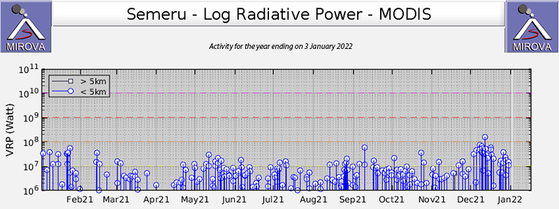 |
Figure 57. The MIROVA project Log Radiative Power data for Semeru shows increasing thermal activity in April 2021 that remained steady through November, and then rose with the increased activity reported in early December. Courtesy of MIROVA. |
Activity during March-June 2021. During March 2021 gray and white emissions from Semeru were observed during 12 days of the month, rising 50-600 m above the summit. Tens of daily seismic events were reported by PVMBG as eruptions, ranging from 102 on 1 March to 10 on 25 March. Seismicity from rock avalanches was infrequent, reported only five days during the month, with one or two events each time, except for 20 March when five rock avalanches were reported. Vibrations from lahars were reported on 3, 11, 13, 14, 18, 30, and 31 March. The Darwin VAAC issued an ash advisory on 2 March for a localized ash emission which rose 400 m above the summit to 4.3 km altitude; it was not observed in satellite imagery. An ash emission on 5 March rose to 3.9 km altitude and drifted N; a hotspot was visible in satellite imagery. The next day a plume at the same altitude drifted S.
Early on 11 March an ash plume was reported by a ground observer at 4.3 km altitude drifting ENE. Later that day a second plume drifted N at the same altitude. Late on 12 March a plume was observed drifting N then NW at 4.3 km altitude; a hotspot at the summit continued into the next day. Late on 15 March an ash emission was reported moving S at 3.9 km altitude; another one occurred at the same altitude on 17 March, but drifted N. A north-drifting plume on 21 March rose to 4.3 km altitude. Two of the 35 seismic eruptions reported on 24 March were observed visually with white and gray emissions rising 500-600 m above the summit and drifting S. Thermal anomalies were visible in Sentinel-2 satellite images on 16 and 26 March; two spots appeared at the summit in both images.
Emissions were largely obscured by clouds and fog during April 2021 with white and gray plumes only reported on 9, 11, 12, 15, and 16 April, rising 50-600 m and drifting N. Tens of daily seismic eruptions continued, ranging from a low of six on 5 April to a high of 51 on 30 April. Three rock avalanches were reported on both 8 and 15 April. A lahar was reported on 1 April. The Darwin VAAC reported intermittent ash emissions to 3.9 km altitude drifting W on 15 and 19 April. The next day discrete emissions drifted N at the same altitude first, then later rose to 4.3 km and continued drifting N. Multiple discrete emissions occurred on 22 April, drifting SE at 4.3 km altitude (figure 58). During 23-24 April emissions drifted S and SE at 3.9-4.3 km altitude and on 28 April they were noted drifting SW at 4.3 km altitude. Multiple Sentinel-2 satellite images, on 10, 20, 25, and 30 April, showed thermal anomalies at the summit (figure 59).
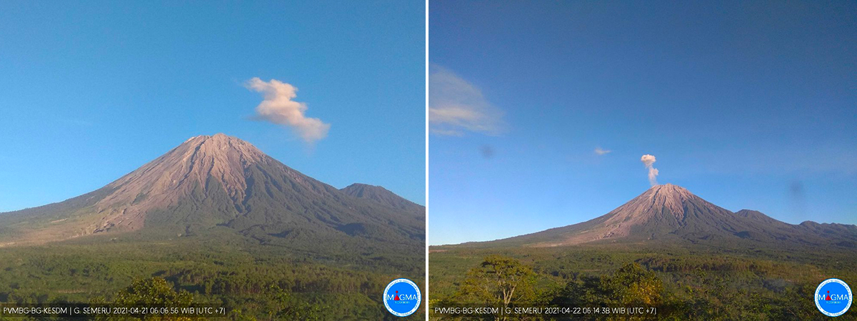 |
Figure 58. Multiple discrete emissions were observed at Semeru during 21 (left) and 22 (right) April 2021. Courtesy of PVMBG and MAGMA Indonesia. |
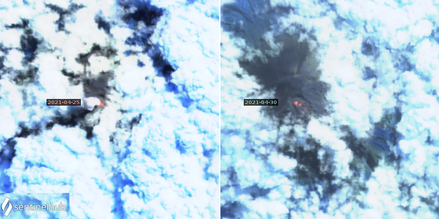 |
Figure 59. Two bright spots of thermal anomaly were present at the summit of Semeru in multiple Sentinel-2 satellite images during April 2021, including on 25 (left) and 30 (right) April. Images use Atmospheric penetration rendering (bands 12, 11, 8a). Courtesy of Sentinel Hub Playground. |
Tens of daily seismically detected eruptions continued during May 2021, ranging from 26-65 each day except 15 May when 80 were reported. Greater visibility during the month allowed for fourteen days when gray and white emissions were observed rising 100-700 m above the summit, drifting either N or S. Rock avalanches were much more frequent than during April, with one or more identified seismically on ten days of the month. They were observed descending 200-700 m down the SE flank towards Besuk (30 km SE) on 6, 8-9, 13, and 18 May. At least three hotspots were identified in thermal satellite images on 5, 10, 15, and 30 May; the 10 May image also indicated incandescent material further down the deep Kobokan ravine on the SE flank (figure 60). MODVOLC thermal alerts were reported on 8, 16, and 18 May. The Darwin VAAC issued ash advisories during 4-5, 8-9, 11-13, 17, 19-22, 27, and 29-30 May. Almost all reported ash at 4.3 km altitude; they drifted in many different directions.
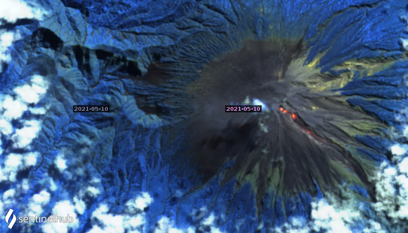 |
Figure 60. Three distinct hotspots at Semeru were recorded in Sentinel-2 thermal satellite imagery multiple times during May 2021. On 10 May a new hotspot at the head of the SE-flank Kobokan ravine was as bright or brighter than the summit anomalies from previous images, and an additional anomaly was present farther down the ravine. Image uses Atmospheric penetration rendering (bands 12, 11, 8a). Courtesy of Sentinel Hub Playground. |
Although gray and white emissions were visible 200-500 m above the summit on only five days during June 2021, between 32 and 55 daily eruptions were recorded seismically, and a few were observed. A single block avalanche was reported on 3 June. The Darwin VAAC reported ash emissions that rose to 3.9-4.3 km altitude on 1-3, 5-7, 10, 15, 17, 19, 24, and 29-30 June drifting primarily W or SW. Sentinel-2 imagery showed one to three thermal anomalies at the summit on 4, 14, 19, 24, and 29 June.
Activity during July-November 2021. Tens of daily seismically detected eruptions continued throughout July 2021, with a high of 68 on 7 July and a low of 33 on 30 July. Gray and white ash emissions were observed rising 200-500 m above the summit on 5-6 and 14 July. A single lahar was reported on 9 July, and a single rock avalanche was recorded on 29 July. Sentinel-2 satellite imagery recorded two or three bright thermal anomalies at the summit crater on 4, 9, 14, 19, 24, and 29 July (figure 61). A single MODVOLC thermal alert was recorded on 10 July. The Darwin VAAC reported ash emissions to 3.9-4.3 km altitude on 1, 3-4, 6, 14, 24-26, and 28 July drifting usually W or SW.
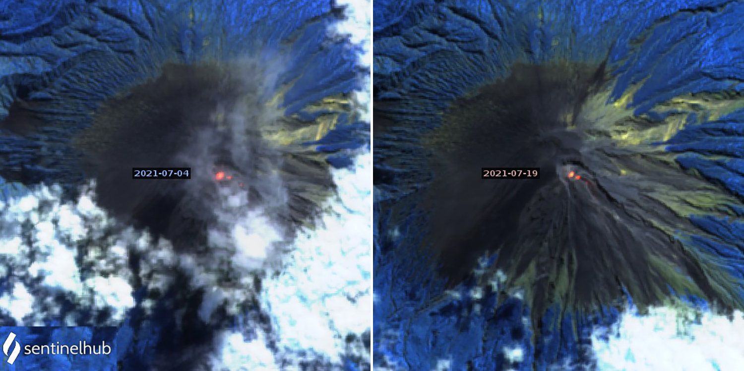 |
Figure 61. Two bright thermal anomalies were present at the summit of Semeru in multiple Sentinel-2 thermal satellite images during July 2021, including on 4 (left) and 19 (right) July. Images use Atmospheric penetration rendering (bands 12, 11, 8a). Courtesy of Sentinel Hub Playground. |
Multiple lahars were reported during 3-5 August 2021. PVMBG also reported incandescent block avalanches descending 200 m down the SE flank from the end of a lava flow within the summit crater during 4-7 August. Tens of daily seismically detected eruptions continued, ranging from 34 on 5 August to 64 on 31 August. Gray and white emissions rising 300-600 m above the summit were reported on 16, 17, and 19 August. Sentinel-2 images indicated multiple thermal anomalies at the summit and on the SE flank on 3, 8, 13, 18, 23, and 28 August. The Darwin VAAC reported ash emissions rising to 3.9-4.3 km altitude and drifting NW and SW on 7-9, 11, 15, 17, 19, 26, and 28-29 August.
White and gray ash emissions were observed 200-700 m above the summit on 2, 15, 16, 20, 22, and 25 September 2021. Daily seismically detected eruptions ranged from 81 on 4 September to 42 on 12 September. Rock avalanche seismicity was reported on 12, 14-16, and 18 September, and incandescent avalanches were observed sliding 500-900 m down the SE flank on 14 and 16 September. PVMBG reported the source of the avalanche as 200 m below the summit on 14 September, and a MODVOLC thermal anomaly was recorded on 16 September. Sentinel-2 satellite imagery on 2, 7, 17, 22, and 27 September all showed thermal anomalies at the summit and on the SE flank (figure 62). The Darwin VAAC reported ash emissions rising to 3.9-4.3 km altitude and drifting SW and W on 1-2, 5, 8-9, 14-19, 22, and 28-29 September.
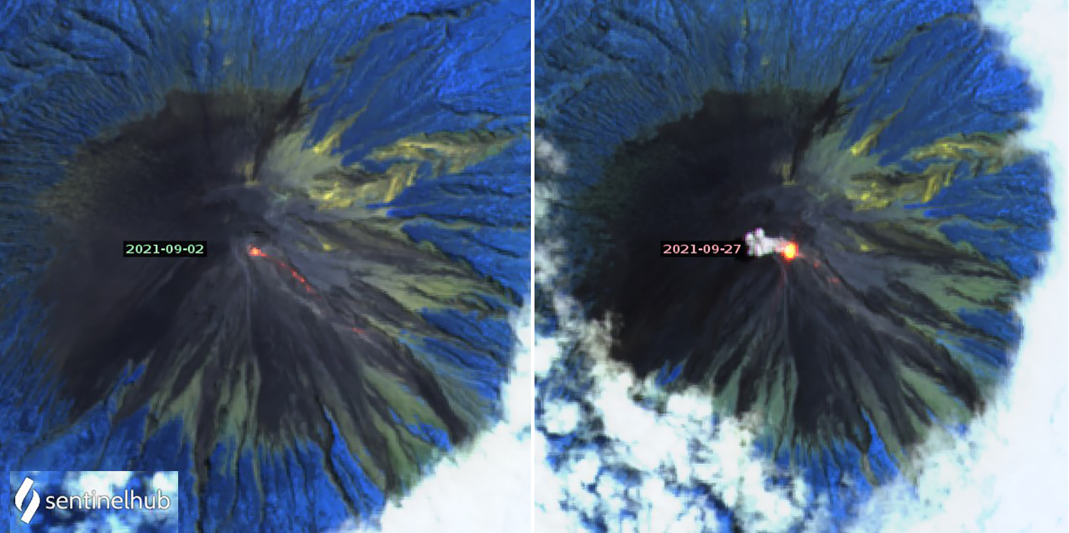 |
Figure 62. All of the Sentinel-2 thermal images for Semeru from September 2021 showed multiple thermal anomalies at the summit and on the SE flank, including those taken on 2 (left) and 27 (right) September. Images use Atmospheric penetration rending (bands 12, 11, 8a). Courtesy of Sentinel Hub Playground. |
Observations of white and gray emissions rising 200-600 m above the summit were made on 11, 12, and 15 October 2021; they were not visible on the other days. Seismically detected eruptions continued with 30-72 reported each day. Sentinel-2 satellite imagery showed thermal anomalies at the summit and on the SE flank on 2, 7, 12, 17, 22, and 27 October; an ash plume obscured the summit in the 12 October image. A single MODVOLC thermal anomaly was recorded on 23 October. The Darwin VAAC reported ash emissions that rose to 3.9-4.3 km altitude and drifted W and S on 10-11, 13, 21, and 31 October.
Daily eruptions continued during November 2021, ranging from 48 detected on 6 November to 95 on 25 November. Gray and white emissions were reported during 2-4 November rising 100-500 m above the summit, and then on most days after 15 November through the end of the month when they rose 100-700 m and drifted in multiple directions. On 26 November, loud noises were heard, gray ash emissions were observed, and incandescent blocks traveled 300 m down the SE-flank Kobokan ravine towards Besek. Ash emissions were reported by the Darwin VAAC on 3, 13, 15-16, 18-25, and 27-28 November; they rose to 3.9-4.3 km altitude and drifted SW, S, and NW. Cloudy skies on 6 and 21 November still revealed thermal anomalies at the summit in Sentinel-2 satellite images.
Activity during December 2021. Tens of seismically detected eruptions were reported daily during 1-5 December but then declined to less than ten per day on most days through 16 December. For the second half of the month, only a few days had three seismically detected eruptions each. The daily number of seismically detected rock avalanches reported increased significantly to more than ten per day most days after 5 December. White and gray emissions were observed about half of the days of the month, and they rose higher than previous months to at least 1,000 m above the summit on multiple occasions.
During 1-2 December loud noises were heard and incandescence at the summit was reported by the local observatory; PVMBG noted that a pyroclastic flow traveled 700 m from the end of a lava flow at the head of the Kobokan ravine, reaching 1,700 m from the summit down the SE-flank towards Besuk. The Darwin VAAC reported an ash emission on 1 December that rose to 3.9 km altitude and drifted N. Incandescent block avalanches sliding 200-800 m below the summit were reported during 2-4 December.
Eko Budi Lelono, head of the Geological Agency of the Ministry of Energy and Mineral Resources, explained in media interviews that days of heavy rain preceded a large explosion and collapse of the summit lava dome on 4 December. This event was followed by multiple pyroclastic flows and lahars during the next several days. The Darwin VAAC observed a large ash plume on 4 December that reached 15.2 km altitude and drifted SW. Pyroclastic flows were then reported originating from the tip of a lava flow in Kobokan ravine, descending up to 2 km for a total distance of 4 km from the summit. Residents described to news outlets sudden darkness in the afternoon from heavy rains and thick clouds of ash, which contributed to dense, hot mudflows that damaged multiple communities. Ongoing eruptive activity resulted in a detached ash plume reported by the Darwin VAAC drifting W at 9.1 km altitude later in the day and a lower altitude ash plume at 4.6 km that drifted S.
Pyroclastic material was deposited in two districts in the Lumajang regency, and eight districts in the neighboring Malang regency were covered with ash according to Badan Nasional Penanggulangan Bencana (BNPB), Indonesia’s disaster management agency. Preliminary estimates suggested that deposits extended at least 16 km SE from the summit. Significant property damage occurred in the area around the village of Curah Kobokan from pyroclastic flows and volcanic mud (figure 63). Pyroclastic flows also destroyed the Gladak Perak bridge, 13 km SE of the summit in Curah Kobokan, which linked residents of Pronojiwo and Lumajang (figure 64); the national road leading to Malang was blocked by tephra and fallen trees. According to news articles and BNPB, by the next day 14 people were confirmed to have died and 57 had been injured and taken to hospitals. About 1,300 people had relocated to evacuation centers or alternative housing.
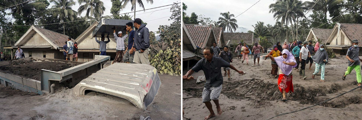 |
Figure 63. Mudflows traveled as far as 16 km from Semeru after a large explosion during rainy weather on 4 December 2021, damaging several communities around the village of Curah Kobokan, burying houses and vehicles in volcanic mud. Numerous districts in the Lumajang and Malang regencies were affected. Tens of casualties were reported. Courtesy of BBC. |
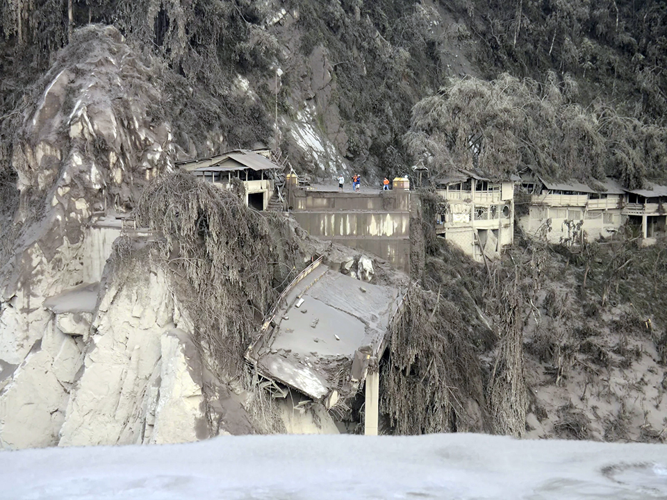 |
Figure 64. Pyroclastic flows and lahars after the large explosion at Semeru on 4 December 2021 destroyed the Gladak Perak bridge in Curah Kobokan village, 13 km SE of the summit, which linked residents of Pronojiwo and Lumajang. Houses were covered with ash, causing many collapsed roofs. Courtesy of NPR. |
Additional pyroclastic flows and lahars during 5-6 December descended down the ravine; the pyroclastic flows traveled at least 700 m from the end of the lava flow reaching total distances of 2.5-3 km from the summit. Incandescent avalanches descended 500-700 m from the summit crater. On 6 December additional pyroclastic flows temporarily halted rescue and recovery efforts. Later that day, the head of BNPB, police officers, and others conducted a 15-minute overflight of the area around Curah Kobokan village and observed steam rising from the deposits (figure 65). Initial estimates were that 2,970 houses and 38 educational facilities across several sub-districts in Lumajang Regency had been destroyed or damaged by the pyroclastic flows and lahars. Authorities who traveled to the fallen bridge and other nearby locations noted damaged vegetation, fallen trees, and volcanic deposits up to 30 cm thick along the road.
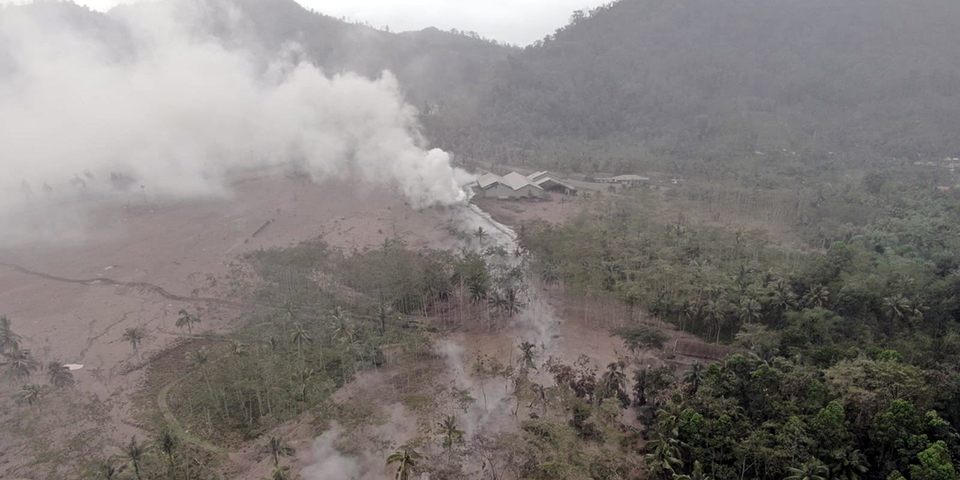 |
Figure 65. Steaming lahar deposits in Sumberwuluh Village in the Candipuro District of the Lumajang Regency are seen here on 6 December 2021 after two days of pyroclastic flows and lahars from Semeru descended the drainage on the SE flank and buried several communities in volcanic mud. Courtesy of BNPB ([Update] – As many as 15 Residents Died and 27 Others Missing Due to Semeru Eruption, 7 December 2021). |
During 6-7 December 2021 the Darwin VAAC noted ash drifting N at 4.3-4.6 km altitude. MAGMA Indonesia reported multiple eruptions during 4-8 December including 3 on 7 December which produced ash plumes that rose 1,000 m above the summit, and 1 on 8 December that generated a 500-m-high ash plume. Two pyroclastic flows traveling 2.5-3.0 km down the SE flank and one lahar were reported on 7 December along with incandescent rock avalanches (figure 66). On 8 December four pyroclastic flows were reported by PVMBG along with additional incandescent rock avalanches, all located in the Kobokan ravine on the SE flank. Sulfur dioxide emissions from Semeru were measured by the TROPOMI Instrument on the Sentinel 5P satellite during 7-12 December (figure 67).
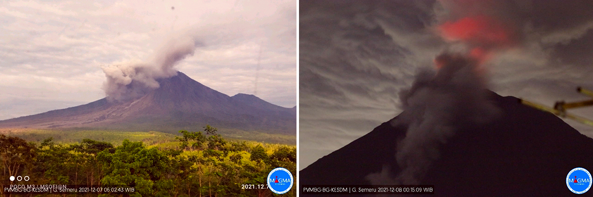 |
Figure 66. Pyroclastic flows and incandescent rock avalanches continued at Semeru during 7-8 December 2021. Courtesy of PVMBG and MAGMA Indonesia. |
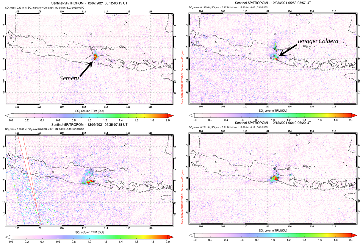 |
Figure 67. Sulfur dioxide emissions from Semeru were measured by the TROPOMI instrument on the Sentinel-5P satellite during 7-12 December 2021. Nearby Tengger Caldera is more frequently a source of SO2. Courtesy of NASA Global Sulfur Dioxide Monitoring Page. |
BNPB reported on 12 December that after a week of search and rescue efforts 45 fatalities were confirmed and over 6,500 people were in evacuation centers after their communities were damaged by mud and volcanic deposits (figure 68). A Sentinel 2 satellite image from 11 December (figure 69) and a clear view of the summit on 12 December (figure 70) both revealed the lava flow that emerged early in December at the head of the Kobokan ravine. The Darwin VAAC reported ash emissions extending N at 4.3 km altitude on 12 December. During 12-15 December intermittent lahars and incandescent avalanches continued to affect the ravine as far as 1,800 m from the summit.
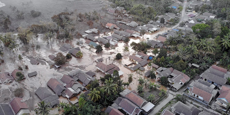 |
Figure 68. Multiple communities in the Candipuro District of Lumajang Regency were flooded filled with mud and volcanic deposits from the early December 2021 activity at Semeru. Courtesy of BNPB ([Update]: A Week of Search and Rescue Efforts, Joint Team Finds a Total of 45 Victims of the Eruption of Mount Semeru, 12 December 2021). |
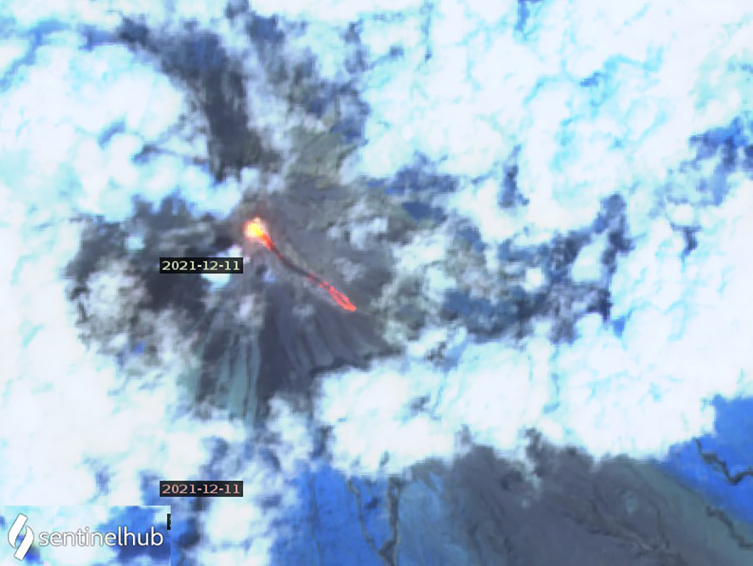 |
Figure 69. A Sentinel-2 satellite image from 11 December 2021 revealed a large thermal anomaly from a new lava flow in the upper part of the Kobokan ravine on the SE flank of Semeru. Image uses Atmospheric penetration rendering (bands 12, 11, 8a). Courtesy of Sentinel Hub Playground. |
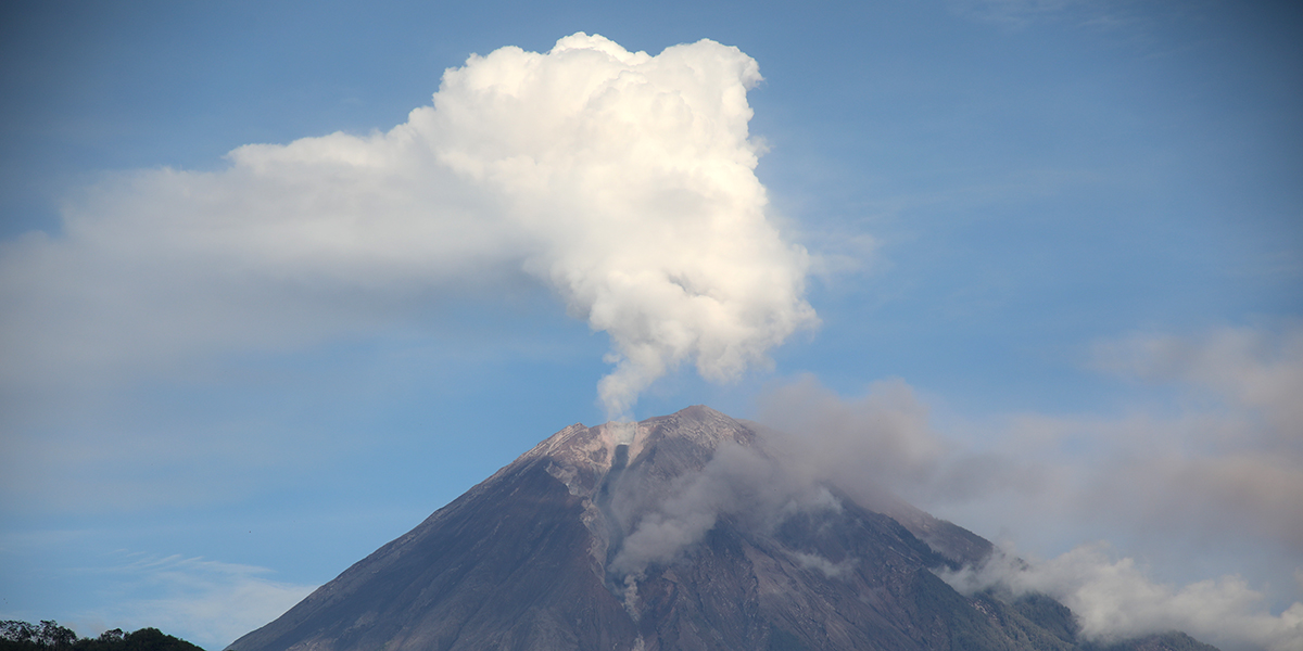 |
Figure 70. A clear view of Semeru on 12 December 2021 revealed steam above the summit and ash from the base of a new lava flow that extended down the Kobokan ravine on the SE flank. Courtesy of BNPB ([Update] – Today 10,400 Residents Are Recorded Spread in 406 Evacuation Points After the Semeru Eruption, 21 December 2021). |
During 16-31 December eleven additional pyroclastic flows, some reaching as far as 5 km from the summit, were recorded; many were accompanied by lahar seismic signals. Incandescence at the summit and incandescent block avalanches also occurred frequently from the front of the 2-km-long lava flow on the SE flank. MAGMA Indonesia reported three eruptions on 16 December and one on 18 December. On 19 December an eruption produced an ash plume that rose 2 km above the summit and drifted SW (figure 71). The next day they reported a 1.5-km-high gray and white emission that drifted SE and a second eruption that was not observed. Sentinel-2 imagery from 21 December indicated thermal anomalies, likely from incandescent avalanches, multiple kilometers down the Kobokan ravine on the SE flank (figure 72). The Darwin VAAC noted suspended ash from a pyroclastic flow on 22 December that rose to 3.9 km altitude and drifted SSW. During 24-25 December the Darwin VAAC reported ash emissions moving SW at 3.9-4.3 km altitude and on 28 December ash was noted drifting N at 3.9 km altitude. Late on 30 December (UTC) they reported an ash plume drifting E at 5.8 km altitude; MAGMA Indonesia reported a dense brown plume from the same eruption on 31 December (local time) that rose 2 km above the summit and drifted N. Nine MODVOLC thermal alerts were reported during December; one on 5 December, three on 12 December, four on 26 December, and one on 28 December. In reports published on 21 and 23 December, BNPB noted that 10,400 residents had been relocated to 406 evacuation centers, and the number of fatalities had reached 51, with additional people still missing.
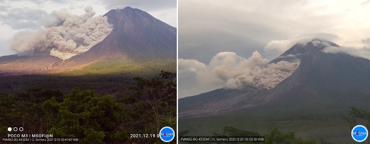 |
Figure 71. Ash plumes rising 1.5-2 km above the summit of Semeru originated from the SE flank near the base of the lava flow on 19 (left) and 20 (right) December 2021, producing pyroclastic flows . Courtesy of PVMBG and MAGMA Indonesia. |
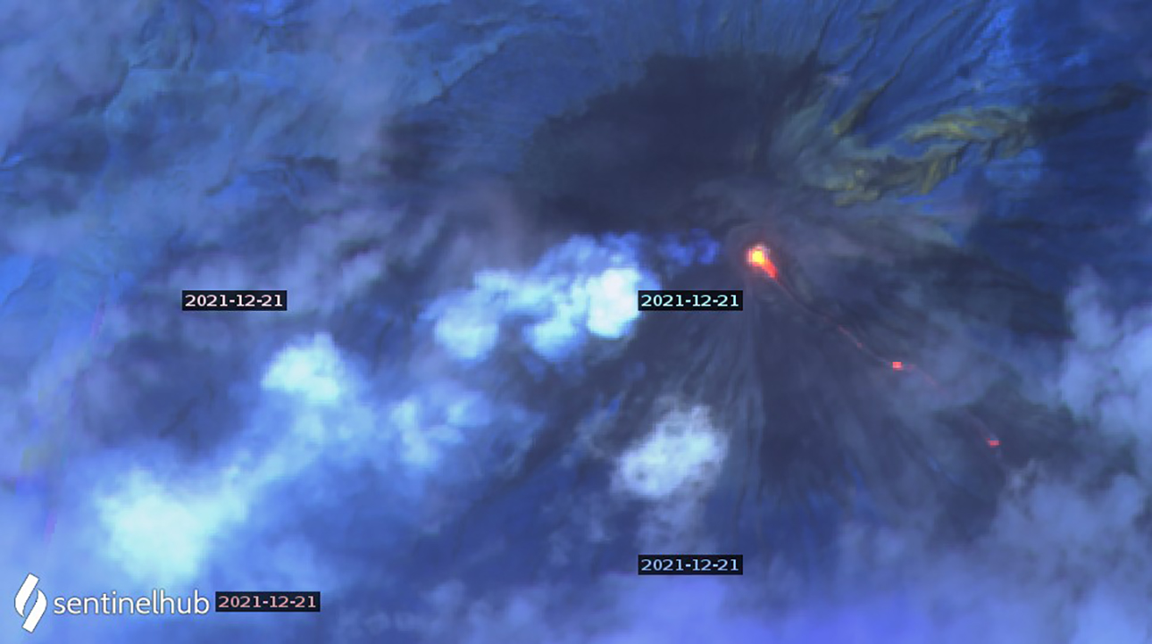 |
Figure 72. Three thermal anomalies appear in a Sentinel 2 satellite image of Semeru from 21 December 2021 along with steam and gas drifting SW from the summit. The bottom right anomaly is about 2 km down the SE flank. Image uses Atmospheric penetration rendering (bands 12, 11, 8a). Courtesy of Sentinel Hub Playground. |
Geological Summary. Semeru, the highest volcano on Java, and one of its most active, lies at the southern end of a volcanic massif extending north to the Tengger caldera. The steep-sided volcano, also referred to as Mahameru (Great Mountain), rises above coastal plains to the south. Gunung Semeru was constructed south of the overlapping Ajek-ajek and Jambangan calderas. A line of lake-filled maars was constructed along a N-S trend cutting through the summit, and cinder cones and lava domes occupy the eastern and NE flanks. Summit topography is complicated by the shifting of craters from NW to SE. Frequent 19th and 20th century eruptions were dominated by small-to-moderate explosions from the summit crater, with occasional lava flows and larger explosive eruptions accompanied by pyroclastic flows that have reached the lower flanks of the volcano.
Information Contacts: Pusat Vulkanologi dan Mitigasi Bencana Geologi (PVMBG, also known as Indonesian Center for Volcanology and Geological Hazard Mitigation, CVGHM), Jalan Diponegoro 57, Bandung 40122, Indonesia (URL: http://www.vsi.esdm.go.id/); Darwin Volcanic Ash Advisory Centre (VAAC), Bureau of Meteorology, Northern Territory Regional Office, PO Box 40050, Casuarina, NT 0811, Australia (URL: http://www.bom.gov.au/info/vaac/); Badan Nasional Penanggulangan Bencana (BNPB), National Disaster Management Agency, Graha BNPB - Jl. Scout Kav.38, East Jakarta 13120, Indonesia (URL: http://www.bnpb.go.id/); MAGMA Indonesia, Kementerian Energi dan Sumber Daya Mineral (URL: https://magma.esdm.go.id/v1); MIROVA (Middle InfraRed Observation of Volcanic Activity), a collaborative project between the Universities of Turin and Florence (Italy) supported by the Centre for Volcanic Risk of the Italian Civil Protection Department (URL: http://www.mirovaweb.it/); Hawai'i Institute of Geophysics and Planetology (HIGP) - MODVOLC Thermal Alerts System, School of Ocean and Earth Science and Technology (SOEST), Univ. of Hawai'i, 2525 Correa Road, Honolulu, HI 96822, USA (URL: http://modis.higp.hawaii.edu/); Sentinel Hub Playground (URL: https://www.sentinel-hub.com/explore/sentinel-playground); National Public Radio (NPR) (URL: https://www.npr.org/2021/12/05/1061611299/indonesia-volcano-eruption-java-mount-semeru); British Broadcasting Corporation (BBC) (URL: https://www.bbc.com/news/world-asia-59532251); NASA Global Sulfur Dioxide Monitoring Page, Atmospheric Chemistry and Dynamics Laboratory, NASA Goddard Space Flight Center (NASA/GSFC), 8800 Greenbelt Road, Goddard MD, USA (URL: https://so2.gsfc.nasa.gov/).