Report on Fuego (Guatemala) — March 2022

Bulletin of the Global Volcanism Network, vol. 47, no. 3 (March 2022)
Managing Editor: Edward Venzke.
Edited by A. Elizabeth Crafford.
Fuego (Guatemala) Lava flows and pyroclastic flows affect multiple ravines in late September 2021
Please cite this report as:
Global Volcanism Program, 2022. Report on Fuego (Guatemala) (Crafford, A.E., and Venzke, E., eds.). Bulletin of the Global Volcanism Network, 47:3. Smithsonian Institution. https://doi.org/10.5479/si.GVP.BGVN202203-342090
Fuego
Guatemala
14.4748°N, 90.8806°W; summit elev. 3799 m
All times are local (unless otherwise noted)
Guatemala's Volcán de Fuego has been erupting vigorously since 2002; reported eruptions date back to 1531. These eruptions have resulted in major ashfalls, pyroclastic flows, lava flows, and damaging lahars, including a series of explosions and deadly pyroclastic flows in early June 2018. Explosions with ash emissions, block avalanches, and lava flows have continued since 2018; activity during August-November 2021 is covered in this report. Daily reports are provided by the Instituto Nacional de Sismologia, Vulcanología, Meteorología e Hidrologia (INSIVUMEH); aviation alerts of ash plumes are issued by the Washington Volcanic Ash Advisory Center (VAAC). Satellite data provide valuable information about thermal anomalies and ash emissions.
The many hourly explosions at Fuego throughout August-November 2021 produced shock waves and vibrations that rattled roofs and windows in communities around the volcano every day, with some heard and felt as far as 20 km away. Ash plumes rose to 4.4-4.8 km altitude every day, occasionally higher, and usually drifted W and SW; the Washington VAAC issued 2-5 ash advisories nearly every day. The explosions produced incandescent block avalanches that descended the flank ravines (barrancas), with a few of the blocks traveling as far as the vegetation near the bottom. The Seca, Ceniza, and Taniluya ravines were most often affected, but blocks were also reported many times in the Trinidad, Santa Teresa, El Jute, Las Lajas, and Honda ravines (figure 152). Incandescent ejecta could be seen rising 100-300 m above the summit on most nights, occasionally higher; the rumblings from the explosions often lasted for several minutes. Ashfall was reported on more than half of the days during August-October, and slightly less than half in November (table 24). Lava flows were active in the Ceniza, Seca and Trinidad ravines beginning on 13 September, and briefly reached up to 1 km in length before cooling by 24 September. Multiple pyroclastic flows descended the Ceniza and Trinidad ravines on 23 September. The MIROVA graph of thermal anomalies showed moderate thermal activity levels with increasing frequency throughout the period (figure 153). MODVOLC thermal alerts were issued on six to ten days each month. Sentinel-2 satellite data showed thermal anomalies inside the summit crater four to six times each month, in most available non-cloudy images.
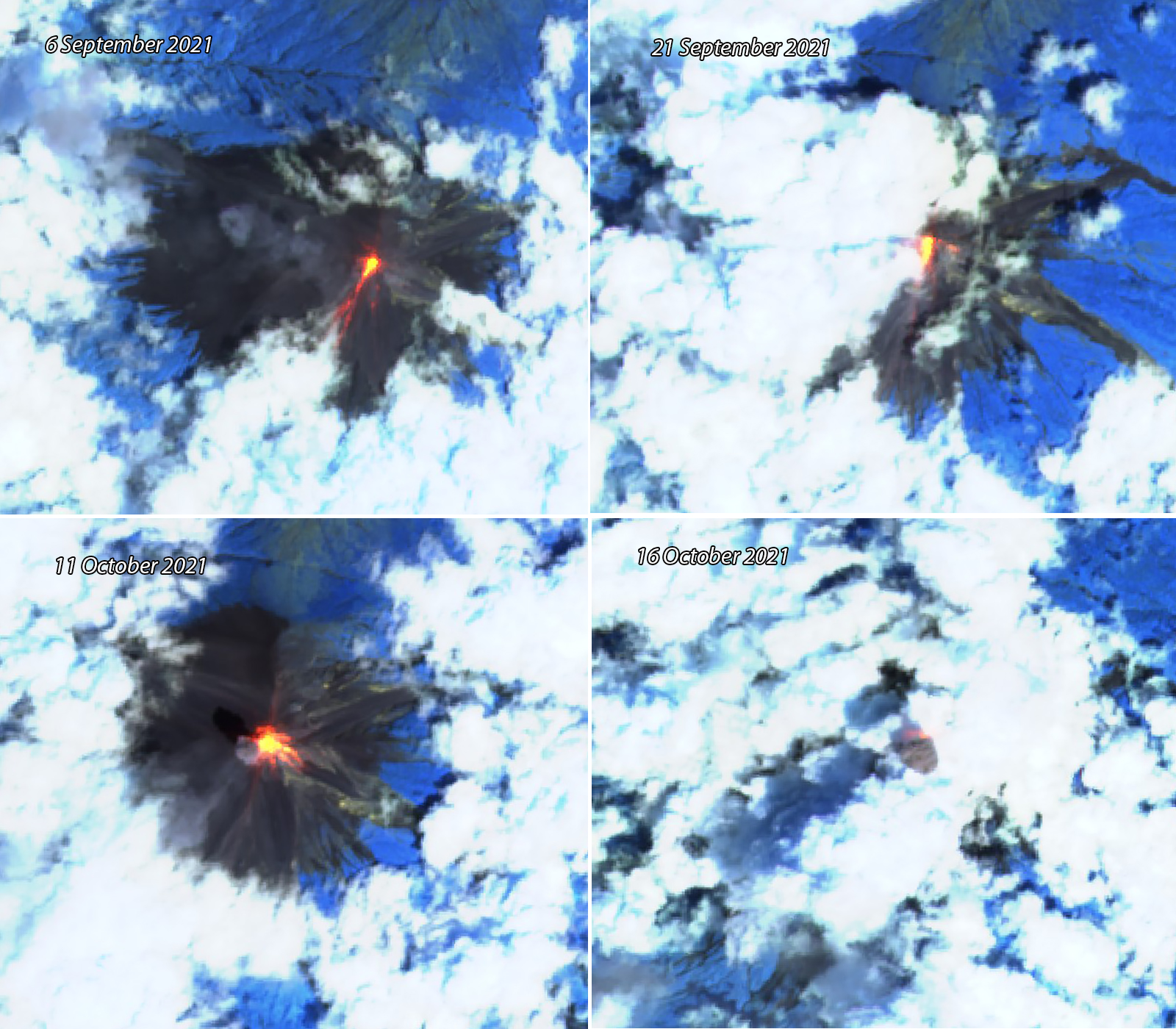 |
Figure 152. Incandescent blocks descended multiple ravines at Fuego daily during August-November 2021, as seen here in Sentinel-2 satellite images. The incandescence on the SW flank in the 6 September image is about 1 km long. Images use Atmospheric penetration rendering (bands 12, 11, 8a). Ash emissions also occurred daily and are seen in the 11 and 16 October images. Courtesy of Sentinel Hub Playground. |
Table 24. Activity at Fuego during August-November 2021 included multiple explosions every hour that produced ash emissions that rose to about 1 km above the summit and drifted generally SW or W as far as 50 km. Incandescent pulses sent ejecta hundreds of meters high, and ashfall was reported in many communities around the volcano. Data from INSIVUMEH daily reports.
| Month | Explosions per hour | Ash plume heights, direction and distance (km) | Incandescent pulses | Communities reporting ashfall |
| Aug 2021 | 3-13 | 4.3-4.8, S, SW, W, up to 15 km | Up to 400 m above the crater, often with a white plume | The areas around Panimaché I and II, Morelia, Santa Sofía, Sangre de Cristo, Yepocapa, Palo Verde, Santa Sofía, Yucales, El Porvenir, La Rochela, Ceilán, San Andrés Osuna |
| Sep 2021 | 5-15 | 4.4-6.0, W, SW up to 20 km | Mostly to 300 m, occasionally 400 m | Panimaché I and II, El Porvenir, Palo Verde, Sangre de Cristo, Morelia, Santa Sofía, Yepocapa, Aldea El Sendero, OVFGO |
| Oct 2021 | 4-14 | 4.5-4.8, W, SW, S, NW up to 50 km | Up to 400 m | Panimaché I and II, Morelia, Santa Sofía, El Porvenir, Finca Palo Verde, Yepocapa, Sangre de Cristo, OVFGO, La Rochela, Ceilan |
| Nov 2021 | 3-14 | 4.3-4.8, W, SW, S, NW, NE, N up to 20 km | Up to 400 m | Panimaché I y II, Morelia, Santa Sofía, El Porvenir, Palo Verde, Sangre de Cristo y San Pedro Yepocapa, La Rochela, OVFGO, volcán Acatenango, Yucales |
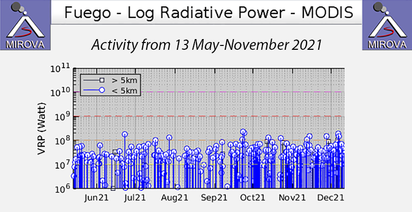 |
Figure 153. The MIROVA graph showed moderate levels of thermal activity, increasing in frequency throughout the period from 13 May through November 2021. Courtesy of MIROVA. |
During August 2021 explosions occurred at a rate of 5-13 per hour, producing ash plumes that rose to 4.3-4.8 km altitude, and drifted W, SW, and S. Ash was reported as far as 15 km from the volcano on 9, 14, 23-24, and 28 August. Shock waves rattled windows and roofs around the volcano every day and were felt up to 15 km away on the S and SW flanks on 10, 13, and 25 August. On 15 and 19 August the vibrations were felt up to 30 km S and 20 km SW. Pulses of incandescent ejecta usually rose 100-300 m but reached 400 m at least four times. MODVOLC thermal alerts were recorded on six days of the month. Ashfall was reported on 20 days of the month. The most frequently impacted communities were Panimaché I and II, Morelia, Santa Sofía, Sangre de Cristo, Yepocapa, Palo Verde, Santa Sofía, Yucales, and El Porvenir. La Rochela, Ceilán, and San Andrés Osuna received ashfall on 14 and 27 August.
Multiple lahars were reported throughout the month. During 6 and 8 August 2021 they descended the Las Lajas, El Jute, Ceniza, and Seca ravines on the S, SW, and SE flanks. Blocks were 1-2 m in diameter traveling in a fine-grained pasty sediment also carrying tree branches and other debris. Blocks up to 3 m were reported in the Seca ravine on 8 August. On 12 and 15 August lahars descended the Ceniza, Las Lajas, and El Jute ravines with blocks between 30 cm and 2 m. Large amounts of rainfall on 20 August produced significant lahars in Las Lajas, El Jute, Ceniza, Seca, Mineral, and Taniluya ravines. The lahar that entered the Pantaleon river from the Seca, Mineral, and Taniluya ravines was 35 m wide, 2 m deep, and had rocks and tree branches 1-2 m in diameter. It caused inundation of the lower part of El Cajon and other communities in that area. Heavy rains on 29-30 August also produced lahars in the Seca and Ceniza ravines. The flow in the Pantaleon river was 25 m wide, 1.5 m high, and carried blocks up to 1.5 m in diameter from those lahars (figure 154).
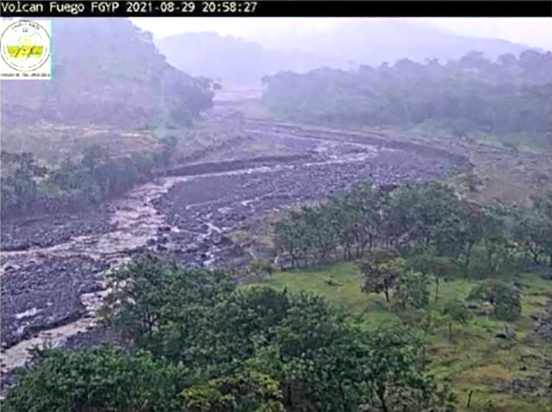 |
Figure 154. Heavy rains on 29-30 August 2021 at Fuego produced lahars in the Pantaleon river that were 25 m wide, 1.5 m high, and carried blocks up to 1.5 m in diameter. Courtesy of INSIVUMEH (BOLETÍN VULCANOLÓGICO ESPECIAL BEFGO #114-2021, Lahar barranca Seca-Pantaleon, Guatemala, 29 de Agosto 2021, 15:10 horas (Hora Local). |
Heavy rain continued to produce significant lahars during 1-3 September 2021 and several other days during the month. Rocks up to 2 m in diameter descended the El Jute, Las Lajas, Seca, and Ceniza ravines into the Achiguate and Guacalate rivers, which drained into Rio Pantaleon on the SW flank all three days. On 3 September, debris from La Trinidad ravine produced a 30 m wide lahar and 2 m high in Rio Achiguate that carried blocks 1.5-2 m in diameter. Additional rain on 7 September produced lahars in Las Lajas, El Jute, and Ceniza ravines with 1-2 m size blocks in a slurry of fine-grained mud. On 16 September 1-2 m blocks were reported in lahars in the Las Lajas and Ceniza ravines. Heavy rains during 26-28 September produced lahars in the Seca, Ceniza, El Jute, and Las Lajas ravines with blocks 30 cm to 1.5 m in diameter.
The rate of explosions during September 2021 was 5-16 per hour, increasing significantly during mid-month. The daily ash plumes generally reached 4.5-4.8 km altitude with higher plumes reported during increased activity later in the month. Ashfall was reported on 17 days during the month and affected Panimaché I and II, El Porvenir, Palo Verde, Sangre de Cristo, Morelia, Santa Sofía, Yepocapa, Aldea El Sendero, and OVFGO, the Fuego Observatory. MODVOLC thermal alerts were recorded on eight days of the month. Beginning on 13 September the OVFGO seismic network registered a change in the eruptive patters at Fuego. During the night of 13 September, a lava flow descended 300 m of the Ceniza ravine on the SW flank. Block avalanches spalled off the front of the flow and rolled as far as the vegetation. This activity produced loud noises similar to a train engine that lasted between 5 and 8 minutes and included incandescence visible 200 m above the crater along with constant degassing. Ash emissions rose to 4.6-5.0 km altitude (figure 155).
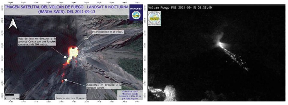 |
Figure 155. A lava flow at Fuego extending 260 m was captured in a Landsat 8 thermal image on 13 September 2021 (left). Constant block avalanches descended the Ceniza ravine (right) most days of the month. Courtesy of INSIVUMEH (BOLETÍN VULCANOLÓGICO ESPECIAL BEFGO #131-2021, Guatemala, 15 de septiembre de 2021, 07:00 horas (Hora Local), CAMBIOS DEL PATRÓN ERUPTIVO). |
Increased seismic activity was reported by OVFGO on the morning of 22 September 2021, along with observations of increased activity visible from the Observatory. Strombolian activity was observed at the crater, and lava flows in the Ceniza (350 m long) and Trinidad (250 m long) ravines were noted. Incandescent blocks from the fronts of the flows, and from the Santa Teresa ravine, all reached vegetation. Activity at the flows increased the next day along with moderate and strong incandescent avalanches in the Ceniza, Trinidad, Taniluya, Santa Teresa, and Las Lajas ravines (figure 156). The blocks from the flow fronts caused ash clouds as they descended the ravines. The loud train-like rumbles were constant and accompanied shock waves that were felt 10 km from the volcano. Early on 23 September a pyroclastic flow descended the Ceniza ravine and traveled 4-6 km to the base of the volcano (figure 157). Additional pyroclastic flows descended the Ceniza and Trinidad ravines a few hours later, reaching 2-4 km down the flanks. They raised ash clouds that covered areas SW and W, resulting in ashfall in Panimaché I, Panimaché II, Morelia, El Porvenir, Santa Sofía, Sangre de Cristo, and San Pedro Yepocapa.
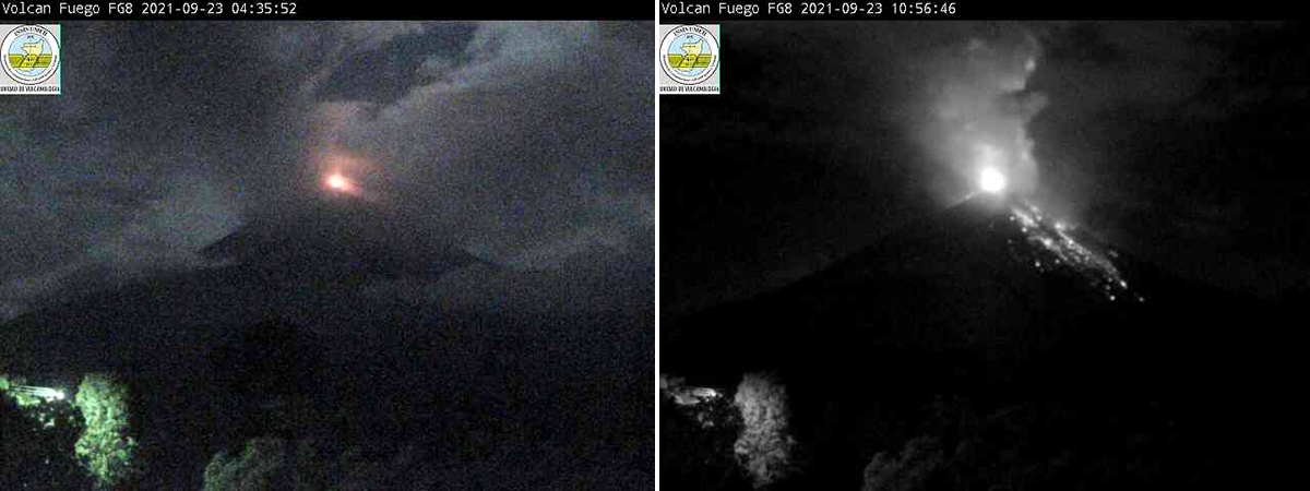 |
Figure 156. Incandescence from lava flows and Strombolian explosions lit up the summit of Fuego on 23 September 2021. Courtesy of INSIVUMEH (BOLETÍN VULCANOLÓGICO ESPECIAL BEFGO #135-2021, Guatemala, 22 de septiembre de 2021, 23:00 horas (Hora Local), INCREMENTO DE ACTIVIDAD; BOLETÍN VULCANOLÓGICO ESPECIAL BEFGO #136-2021, Guatemala, 23 de septiembre de 2021, 05:00 horas (Hora Local), ERUPCIÓN. |
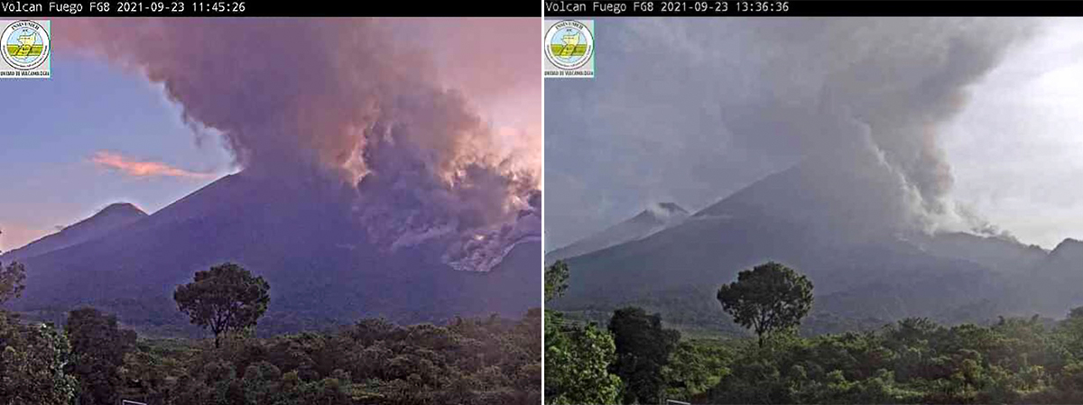 |
Figure 157. Activity increased at Fuego during the second half of September 2021. On 23 September Strombolian activity sent incandescent blocks down all the flanks (left), and a pyroclastic flow descended the Ceniza ravine 4-6 km to the base of the volcano. Courtesy of INISVUMEH (BOLETÍN VULCANOLÓGICO ESPECIAL BEFGO #137-2021, Guatemala, 23 de septiembre de 2021, 05:50 horas (Hora Local), ERUPCIÓN CON DESCENSO DE FLUJOS PIROCLÁSTICOS). |
In a special bulletin released at midday on 23 September INSIVUMEH noted that the Strombolian activity continued, generating lava flows in the Ceniza and Seca ravines that reached 1,200 and 1,000 m, respectively, and pyroclastic flows in the Trinidad and Ceniza ravines that resulted in ashfall in communities W and S of the volcano. All of the activity was accompanied by loud train engine-like noises that increased notably around 1100 local time. Ash plumes rose to around 6 km altitude and drifted W and SW 15-30 km. Seismic stations around the volcano all recorded a sustained increase in energy. By the afternoon continuing pyroclastic flows had sent ash plumes over La Rochela and Ceilan, in addition to the other communities, before they diminished that evening. Sounds from a few of the avalanche blocks descending the Ceniza ravine were audible at the Fuego Observatory. Seismic activity decreased in the evening before another pulse of explosive activity sent incandescent material 250 m above the crater and generated ash plumes that rose to 4.8 km altitude. By the next morning activity had decreased significantly, and by the afternoon of 24 September the lava flows were no longer active.
The hourly explosion rate during October 2021 ranged from 5-14, producing ash plumes that usually rose to 4.5-4.8 km altitude and drifted as far as 15 km, mostly SW; they reached 40 km away on 17 October and 50 km W, NW, and SW on 27 October. Daily vibrations rattled windows and roofs around the volcano, and loud rumblings frequently lasted 1-3 minutes. Pulses of incandescent material often reached 300 m above the crater, sometimes higher, sending blocks down of the ravines as far as the vegetation. MODVOLC thermal alerts were measured on ten days of the month. Ashfall was reported on 17 days of the month and the most affected communities were Panimaché I and II, Morelia, Santa Sofía, El Porvenir, Finca Palo Verde, Yepocapa, Sangre de Cristo, the Fuego Observatory, La Rochela, and Ceilan. Lahars were reported in the Seca, Mineral, Taniluya, and Ceniza ravines on 19 and 22 October; volcanic blocks as large as 2 m were reported in the Pantaleon river downstream.
Ash plumes rose daily during November 2021 to 4.3-4.8 km altitude from the 3-14 per hour explosions. Incandescent blocks descended all the ravines and ejecta rose as high as 400 m above the summit on many days. MODVOLC thermal alerts were issued on eight days of the month. On most days the rumbles from the explosions lasted for 1-3 minutes, but longer period vibrations lasting 5-10 minutes were reported on 14, 19, 26, and 30 November. Ashfall was reported on 10 days during the month, and the most affected communities were Panimaché I and II, Morelia, Santa Sofía, El Porvenir, Palo Verde, Sangre de Cristo, San Pedro Yepocapa, La Rochela, OVFGO, volcán Acatenango, and Yucales. There were no lahars reported during the month.
Geological Summary. Volcán Fuego, one of Central America's most active volcanoes, is also one of three large stratovolcanoes overlooking Guatemala's former capital, Antigua. The scarp of an older edifice, Meseta, lies between Fuego and Acatenango to the north. Construction of Meseta dates back to about 230,000 years and continued until the late Pleistocene or early Holocene. Collapse of Meseta may have produced the massive Escuintla debris-avalanche deposit, which extends about 50 km onto the Pacific coastal plain. Growth of the modern Fuego volcano followed, continuing the southward migration of volcanism that began at the mostly andesitic Acatenango. Eruptions at Fuego have become more mafic with time, and most historical activity has produced basaltic rocks. Frequent vigorous eruptions have been recorded since the onset of the Spanish era in 1524, and have produced major ashfalls, along with occasional pyroclastic flows and lava flows.
Information Contacts: Instituto Nacional de Sismologia, Vulcanologia, Meteorologia e Hydrologia (INSIVUMEH), Unit of Volcanology, Geologic Department of Investigation and Services, 7a Av. 14-57, Zona 13, Guatemala City, Guatemala (URL: http://www.insivumeh.gob.gt/ ); MIROVA (Middle InfraRed Observation of Volcanic Activity), a collaborative project between the Universities of Turin and Florence (Italy) supported by the Centre for Volcanic Risk of the Italian Civil Protection Department (URL: http://www.mirovaweb.it/); Hawai'i Institute of Geophysics and Planetology (HIGP) - MODVOLC Thermal Alerts System, School of Ocean and Earth Science and Technology (SOEST), Univ. of Hawai'i, 2525 Correa Road, Honolulu, HI 96822, USA (URL: http://modis.higp.hawaii.edu/); Washington Volcanic Ash Advisory Center (VAAC), Satellite Analysis Branch (SAB), NOAA/NESDIS OSPO, NOAA Science Center Room 401, 5200 Auth Rd, Camp Springs, MD 20746, USA (URL: www.ospo.noaa.gov/Products/atmosphere/vaac, archive at: http://www.ssd.noaa.gov/VAAC/archive.html); Sentinel Hub Playground (URL: https://www.sentinel-hub.com/explore/sentinel-playground).