Report on Karymsky (Russia) — June 2022
Bulletin of the Global Volcanism Network, vol. 47, no. 6 (June 2022)
Managing Editor: Benjamin Andrews.
Edited by Kadie L. Bennis.
Karymsky (Russia) Strong ash explosions and ashfall during November 2021-April 2021
Please cite this report as:
Global Volcanism Program, 2022. Report on Karymsky (Russia) (Bennis, K.L., and Andrews, B., eds.). Bulletin of the Global Volcanism Network, 47:6. Smithsonian Institution. https://doi.org/10.5479/si.GVP.BGVN202206-300130
Karymsky
Russia
54.049°N, 159.443°E; summit elev. 1513 m
All times are local (unless otherwise noted)
Karymsky is located in Kamchatka’s eastern volcanic zone and was constructed within a 5-km-wide caldera during the early Holocene. Its first observed eruption occurred in 1771, with more recent activity characterized by ash explosions, ash plumes, gas-and-steam plumes, and thermal anomalies. The current eruption began in April 2020 and has primarily consisted of ash explosions and ash plumes (BGVN 46:11). This report updates information during November 2021 through April 2022 using daily, weekly, and special reports from the Kamchatka Volcanic Eruptions Response Team (KVERT), the Tokyo and Anchorage Volcanic Ash Advisory Centers (VAAC), and satellite data.
Strong ash explosions occurred in the beginning of November, accompanied by frequent ash plumes. On 1 November explosions generated an ash plume to 3.5 km altitude that drifted 35-50 km SE and ESE. According to the Tokyo VAAC, ash plumes rose as high as 7.9 km altitude on 3 November and drifted SE and E. A significant explosive eruption on 4 November produced notable ash plumes that were described in a series of VONAs issued by KVERT and the Tokyo and Anchorage VAACs. The plume on 4 November rose to 10.5 km altitude and extended as far as 2,800 km over the Pacific Ocean. Satellite images acquired at 1750 showed two large ash clouds drifting 1,090 km E and 460 km SE. Ashfall was observed the next day at Medny Island and Berin Island. On 5 November ash plumes rose to 3-5.5 km altitude and drifted E and NE. On 6 November another strong explosive event produced an ash plume that rose to 8 km altitude and drifted 500 km ENE and 61 km ESE, which prompted KVERT to raise the Aviation Color Code (ACC) to Red (the highest level on a four-color scale). On 7 November an ash plume rose to 4.8-6 km altitude and drifted 110 km NE and 90 km NW; KVERT lowered the ACC to Orange (the second high level on a four-color scale). Ash explosions continued intermittently through 25 November, with plumes rising to 8 km and drifting in different directions as far as 400 km. Thermal anomalies accompanying ash plumes were often visible. During 2-3 December ash explosions generated plumes that rose to 4.5 km altitude that drifted 235 km ENE, accompanied by a thermal anomaly. Anomalies were also occasionally visible in satellite imagery through the rest of the month.
Similar activity persisted in January; thermal anomalies were intermittently observed in satellite imagery. On 11 January an explosion sent ash up to 5 km altitude and drifted 80 km SW. On 13 January an ash plume rose to 6 km altitude and extended 10 km NNW. Ash explosions on 15 and 17 January generated ash plumes that rose to 7 km altitude and drifted 172 km W. During February, no explosions were reported by KVERT, thermal anomalies, however, were visible in satellite imagery throughout the month.
Low activity occurred during March and into late April, consisting dominantly of occasional thermal anomalies. On 20 April a powerful explosive event at 0905 produced an ash plume that rose to 11 km altitude and drifted more than 2,000 km NE (figure 64). As a result, ashfall was reported on the territory of the Kronotsky Reserve (Semyachinsky, Valley of Geysers; 50 km NE), and at Cape Nalychevo (100 km S) and KVERT raised the ACC to Red. Plumes continued to rise 5-8.7 km altitude and drifted 302 km NE, 260 km S, and 220 km SE. By 1544, the ACC was lowered to Orange. Ash explosions continued to be reported during 17-19, 21-22, and 28 April, with ash plumes rising as high as 10 km altitude on 28 April at 1410. Plumes drifted 500 km NE, SW, SE, and E during 17-19 and 21 April, 95 km E and SE during 21-22, and as far as 1,000 km WNW on 28 April.
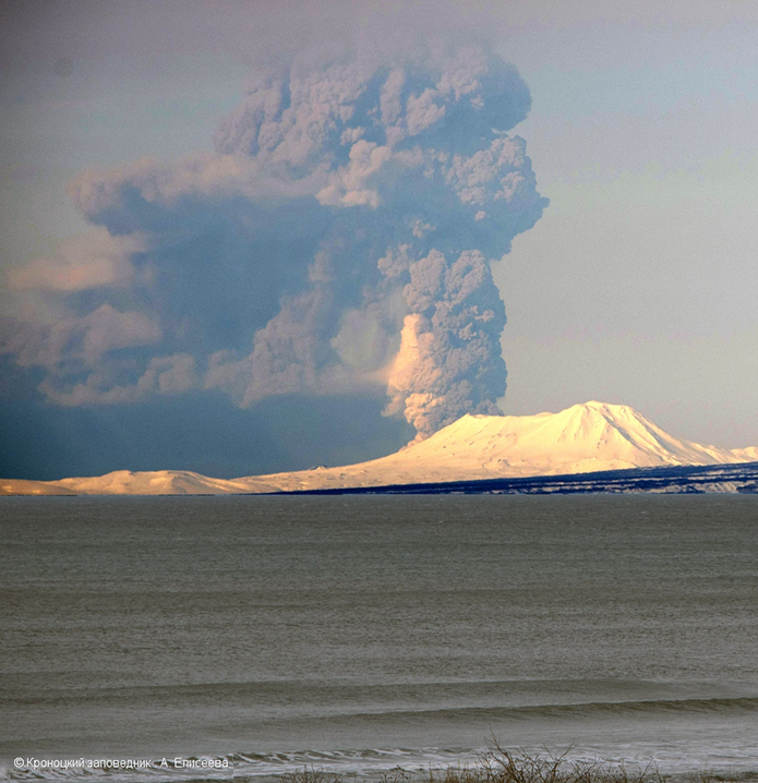 |
Figure 64. Photo of a large ash plume rising to 10 km altitude from Karymsky on 19 April 2022. Taken from Olga Bay of Kronotsky Bay, Maly Semyachik Volcano in the foreground. Courtesy of A. Eliseeva, Kronotsky Reserve, KVERT. |
MIROVA (Middle InfraRed Observation of Volcanic Activity) analysis of MODIS satellite data showed a strong pulse in thermal activity in early to mid-November (figure 65). By late November, both the strength and frequency of those anomalies had sharply declined. Two anomalies were detected during early December, and one occurred near the end of the month. After that, thermal activity was relatively low, consisting of only one anomaly in late January, and one in late February. In late April, activity briefly increased again, with about six moderate thermal anomalies. According to data from the MODVOLC thermal algorithm, a total of 15 thermal alerts were detected: 10 on 3 November, one on 4 November, one on 5 November, one on 20 April 2022, and two on 22 April. During clear weather days, this thermal activity on 5 November and 22 April was strongly visible in Sentinel-2 infrared satellite imagery (figure 66). Occasional ash plumes and gas-and-steam emissions were also visible in satellite images; however, on 22 April, at least four lava flows were visible descending the SW, S, and E flanks.
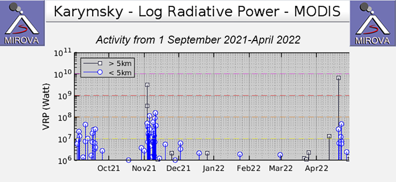 |
Figure 65. A strong pulse of thermal activity was detected in November 2021 at Karymsky, which rapidly decreased by the end of the month, according to this MIROVA graph (Log Radiative Power). Three anomalies were detected in December 2021 and activity remained low through late April, with one anomaly occurring in late January 2022 and one in late February 2022. Another small pulse in thermal activity occurred in late April that consisted of six anomalies. Courtesy of MIROVA. |
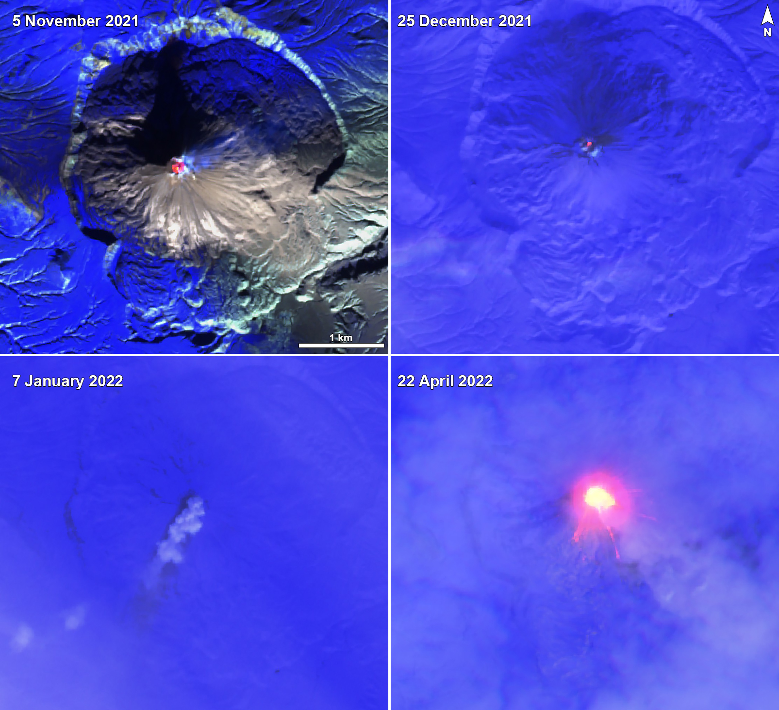 |
Figure 66. Sentinel-2 infrared satellite images show a strong thermal anomaly at the summit crater of Karymsky on 5 November 2021 (top left) and 22 April 2022 (bottom right). A weaker anomaly was visible on 25 December 2021 (top right). Frequent gas-and-steam emissions also accompanied these anomalies. On 7 January 2022 (bottom left), an ash plume drifted SW, depositing some ash near the crater and on the SW flank (light black color). On 22 April at least four lava flows were visible descending the SW, S, and E flanks. Sentinel-2 satellite images with “Atmospheric penetration” (bands 12, 11, 8A) rendering. Courtesy of Sentinel Hub Playground. |
Geological Summary. Karymsky, the most active volcano of Kamchatka's eastern volcanic zone, is a symmetrical stratovolcano constructed within a 5-km-wide caldera that formed during the early Holocene. The caldera cuts the south side of the Pleistocene Dvor volcano and is located outside the north margin of the large mid-Pleistocene Polovinka caldera, which contains the smaller Akademia Nauk and Odnoboky calderas. Most seismicity preceding Karymsky eruptions originated beneath Akademia Nauk caldera, located immediately south. The caldera enclosing Karymsky formed about 7600-7700 radiocarbon years ago; construction of the stratovolcano began about 2000 years later. The latest eruptive period began about 500 years ago, following a 2300-year quiescence. Much of the cone is mantled by lava flows less than 200 years old. Historical eruptions have been vulcanian or vulcanian-strombolian with moderate explosive activity and occasional lava flows from the summit crater.
Information Contacts: Kamchatka Volcanic Eruptions Response Team (KVERT), Far Eastern Branch, Russian Academy of Sciences, 9 Piip Blvd., Petropavlovsk-Kamchatsky, 683006, Russia (URL: http://www.kscnet.ru/ivs/kvert/); Tokyo Volcanic Ash Advisory Center (VAAC), 1-3-4 Otemachi, Chiyoda-ku, Tokyo 100-8122, Japan (URL: http://ds.data.jma.go.jp/svd/vaac/data/); Anchorage Volcanic Ash Advisory Center (VAAC), Alaska Aviation Weather Unit, NWS NOAA US Dept of Commerce, 6930 Sand Lake Road, Anchorage, AK 99502-1845 USA (URL: http://vaac.arh.noaa.gov/); MIROVA (Middle InfraRed Observation of Volcanic Activity), a collaborative project between the Universities of Turin and Florence (Italy) supported by the Centre for Volcanic Risk of the Italian Civil Protection Department (URL: http://www.mirovaweb.it/); Hawai'i Institute of Geophysics and Planetology (HIGP) - MODVOLC Thermal Alerts System, School of Ocean and Earth Science and Technology (SOEST), Univ. of Hawai'i, 2525 Correa Road, Honolulu, HI 96822, USA (URL: http://modis.higp.hawaii.edu/); Sentinel Hub Playground (URL: https://www.sentinel-hub.com/explore/sentinel-playground).