Report on Soputan (Indonesia) — October 1982
Scientific Event Alert Network Bulletin, vol. 7, no. 10 (October 1982)
Managing Editor: Lindsay McClelland.
Soputan (Indonesia) Strongest explosion since eruption began
Please cite this report as:
Global Volcanism Program, 1982. Report on Soputan (Indonesia) (McClelland, L., ed.). Scientific Event Alert Network Bulletin, 7:10. Smithsonian Institution. https://doi.org/10.5479/si.GVP.SEAN198210-266030
Soputan
Indonesia
1.112°N, 124.737°E; summit elev. 1785 m
All times are local (unless otherwise noted)
VSI reported that explosive activity resumed at 2045 on 9 November. Ash rose to ~5 km altitude and was blown NW, falling in the city of Amurang, 20 km away. A light ashfall was also reported at the VSI's Kakaskasen Observatory, 30 km N of Soputan. Newspapers reported that ash fell 40 km from the volcano and that within hours streets near the volcano were covered by as much as 10 cm of ash, halting traffic in many areas. VSI reported that rumbling and detonations accompanied the activity, and lightning flashes were observed at 4 km altitude. The eruption ended at about 1800 on 10 November, and no rumbling was heard that night.
A VSI seismograph at Silian, 6 km S of the volcano, recorded tremors for 4 hours before the eruption. The Teledyne seismograph, set at a magnification of 2,000, indicated a maximum amplitude of 6 mm during the early morning of 10 November and 4 mm in the afternoon. Deep (tectonic) earthquakes and two shallow volcanic events also preceded the explosive activity.
The GMS satelliteshowed no activity from Soputan at 1700, but on the next image, at 2000, there was a plume extending ~150 km W from the volcano. From the plume's development and rate of drift, satellite specialists estimated that gas emission had begun shortly after 1700, or well before the first explosive activity noticed on the ground at 2045. By 0200 on 10 November, relatively diffuse, apparently low-level material was drifting N and NW, while higher-altitude ejecta formed a dense plume that moved almost directly W. Satellite data continued to show feeding of the cloud through 1400 on 10 November. On the next image, at 1700, the cloud had separated from the volcano. By 2000, a plume with dense and diffuse patches extended from about 3°N, 123°E to 4°S, 117°E, a length of more than 1,000 km, and had a maximum width of ~500 km, considerably larger than the August and September plumes.
Further Reference. Sawada, Y., 1983, Attempt on surveillance of volcanic activity by eruption cloud image from artificial satellite: Bulletin of the Volcanological Society of Japan, v. 28, p. 357-373.
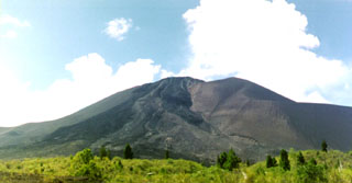
Geological Summary. The Soputan stratovolcano on the southern rim of the Quaternary Tondano caldera on the northern arm of Sulawesi Island is one of Sulawesi's most active volcanoes. The youthful, largely unvegetated volcano is the only active cone in the Sempu-Soputan volcanic complex, which includes the Soputan caldera, Rindengan, and Manimporok (3.5 km ESE). Kawah Masem maar was formed in the W part of the caldera and contains a crater lake; sulfur has been extracted from fumarolic areas in the maar since 1938. Recent eruptions have originated at both the summit crater and Aeseput, a prominent NE-flank vent that formed in 1906 and was the source of intermittent major lava flows until 1924.
Information Contacts: A. Sudradjat and Suratman, VSI; D. Haller and M. Matson, NOAA; Sinar Harapan, Jakarta; AFP.

