Report on Semeru (Indonesia) — December 1985
Scientific Event Alert Network Bulletin, vol. 10, no. 12 (December 1985)
Managing Editor: Lindsay McClelland.
Semeru (Indonesia) Frequent explosions and lava extrusion throughout 1985
Please cite this report as:
Global Volcanism Program, 1985. Report on Semeru (Indonesia) (McClelland, L., ed.). Scientific Event Alert Network Bulletin, 10:12. Smithsonian Institution. https://doi.org/10.5479/si.GVP.SEAN198512-263300
Semeru
Indonesia
8.108°S, 112.922°E; summit elev. 3657 m
All times are local (unless otherwise noted)
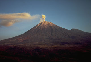
"Semeru has been active throughout 1985. The principal activity consisted of frequent small Vulcanian explosions and slow lava extrusion from the summit vent, small rockfalls from the steep-sided walls of the summit lava plug, and occasional nuées ardentes d'avalanche from the lava flow, where it rests on the steep SE flank of the summit cone. These small pyroclastic flows generally remain within 5 km of the summit vent. Typical maximum cloud height for the small Vulcanian explosions is 1,000 m or less. The frequency of explosions decreased steadily from 3,832 in May (125/day) to 1,797 in December (60/day). The monthly average number of rockfalls was about 320. The maximum number of nuées ardentes d'avalanche was 18 in July, declining from 15 in August to five in December (table 1). The composition of a breadcrust bomb sample collected on 17 August is shown in table 2."
Table 1. Monthly numbers of explosions, rockfalls, and nuées ardentes d'avalanche at Semeru, April-December 1985. Explosion and rockfall counts are from seismic records; nuées ardentes are counted from extended rockfall signals on seismic records and from observations from Gunungsawur Observatory at 650 m altitude, 12 km SE of the summit.
| Month | Explosions | Rockfalls | Nuees Ardentes |
| Apr 1985 | 2529 | 179 | 0 |
| May 1985 | 3832 | 323 | 0 |
| Jun 1985 | 3748 | 437 | 5 |
| Jul 1985 | 3321 | 364 | 18 |
| Aug 1985 | 3192 | 341 | 15 |
| Sep 1985 | 2357 | 303 | 12 |
| Oct 1985 | 2315 | 475 | 10 |
| Nov 1985 | 1464 | 224 | 6 |
| Dec 1985 | 1797 | 320 | 5 |
Table 2. Whole rock analyses of breadcrust bomb sample collected from Semeru, 17 August 1985. X-ray fluorescence analyses by the USGS Laboratory, Denver, Colorado. Total iron expressed as Fe2O3; loss on ignition at 900°C.
| Component | Value (%) |
| SiO2 | 56.8 |
| Al2O3 | 19.9 |
| Fe2O3 | 7.61 |
| MgO | 2.28 |
| CaO | 8.09 |
| Na2O | 3.45 |
| K2O | 1.22 |
| TiO2 | 0.70 |
| P2O5 | 0.18 |
| MnO | 0.18 |
| LOI | 0.01 |
Further Reference. Suryo, I., 1986, Semeru: Bulletin of the Volcanological Survey of Indonesia, no. 111, 52 p.
Geological Summary. Semeru, the highest volcano on Java, and one of its most active, lies at the southern end of a volcanic massif extending north to the Tengger caldera. The steep-sided volcano, also referred to as Mahameru (Great Mountain), rises above coastal plains to the south. Gunung Semeru was constructed south of the overlapping Ajek-ajek and Jambangan calderas. A line of lake-filled maars was constructed along a N-S trend cutting through the summit, and cinder cones and lava domes occupy the eastern and NE flanks. Summit topography is complicated by the shifting of craters from NW to SE. Frequent 19th and 20th century eruptions were dominated by small-to-moderate explosions from the summit crater, with occasional lava flows and larger explosive eruptions accompanied by pyroclastic flows that have reached the lower flanks of the volcano.
Information Contacts: Suparto S. and T. Casadevall, VSI.

