Report on Akutan (United States) — May 1986
Scientific Event Alert Network Bulletin, vol. 11, no. 5 (May 1986)
Managing Editor: Lindsay McClelland.
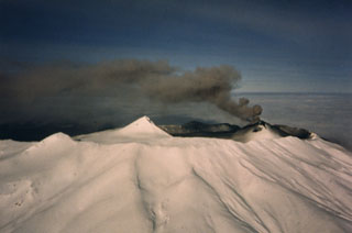
Akutan (United States) Steam and ash emission
Please cite this report as:
Global Volcanism Program, 1986. Report on Akutan (United States) (McClelland, L., ed.). Scientific Event Alert Network Bulletin, 11:5. Smithsonian Institution. https://doi.org/10.5479/si.GVP.SEAN198605-311320
Akutan
United States
54.134°N, 165.986°W; summit elev. 1303 m
All times are local (unless otherwise noted)
Increased steam emission . . . was reported on 31 December and plumes rising to estimated altitudes of as much as 5.2 km . . . have been occasionally observed since then. Ash was first visible in a plume on 18 March and numerous ash columns were seen 1-7 June. No ashfalls have been reported this year in Akutan village, 12 km E of the volcano, but fresh-looking ash was observed 5 June on the upper NE flank.
John Reeder provided the following pilot and ground observations. On 31 December at about 1100, James and Abi Dickson observed an anomalously large white apparently ash-free steam plume over Akutan. From Dutch Harbor airport (46 km from the volcano), the plume height was estimated at 550 m. The plume remained visible in clear, fairly calm weather until sunset, at around 1600. On 3 February at 1000, James Dickson noted a large vertical steam plume emerging from the vicinity of the volcano and by 1400, the plume height had roughly doubled. From Unalaska (47 km from Akutan), Abi Dickson estimated the plume's maximum altitude at 5.2 km. Maximum plume width was about 900 m.
On 18 March, Aleutian Air pilot T. Madsen observed weak but steady ejection of steam and black ash from Akutan's cinder cone. During his next overflight, on 22 March, ash ejection had stopped. The crater seemed to have enlarged slightly and appeared to be more centrally located than its previous position on the NW part of the summit. Minor steam venting was occurring from the upper and lower N and S flanks, but no steam was emerging from the central crater.
On 28 April at about 1530, Reeve Aleutian captain Lee Goch observed a large billowing white plume over Akutan, reaching ~2 km altitude and extending ~8 km SW. By 1539, the end of the plume was 16 km SW of the volcano. Nothing unusual had been evident . . . when he flew past 1.5 hours earlier. Immediately after hearing Goch's radio report, AirPac pilot Nickol Sias flew to within 300 m of the active cinder cone. It was vigorously emitting a white steam column. There was no ash in the plume and no new ash deposits were evident on the cinder cone, the caldera floor, or the volcano's flanks. Most of the cinder cone was covered with fresh snow, but fairly large circular melt areas on its N and S sides extended nearly to its base. Minor steaming was occurring from both melt areas. Two days later at 1615, Goch observed a steam plume that rose only ~150 m before drifting ~50 km E. On 1 May, fisherman Halvor Ostebovik noted a long brownish horizontal haze from ~16 km N of Akutan Island.
While flying at 430 m altitude just over the NW rim of the caldera on 6 May at about 0920, T. Madsen encountered sulfur-rich volcanic gases that severely irritated his eyes. A billowing steam cloud emerged steadily from the black cinder cone. On 6 and 7 May at about 1300, MarkAir captain Jerry Chisum saw steam plumes (with no obvious ash) rising at about a 45° angle to 1,100 m height. The plume drifted WNW on the 6th and S on the 7th. Madsen saw a very light gray plume that moved ~30 km S . . . about an hour before Chisum's flight on the 7th. Activity was similar just before noon the next day. At 1530, Goch reported only a 30-m plume from the volcano, but noted two craters on the cinder cone, one N and one S of its summit. On 10 May, Madsen saw very little steam emerging from the snow-free cone.
The USGS reports that personnel from the Trident Fisheries cannery in Akutan village observed numerous eruptive episodes in a 3.5-hour period on 1 June: 0715, grayish black cloud to ~3 km altitude; 0800, black cloud to 3.5 km; 0830, steam-rich cloud to 2 km; 0912, grayish cloud to 2.5 km; 0940, light-colored steam-rich cloud to 2.5 km; 1020, dense black cloud to 3.5 km; 1038, black cloud passed through weather cloud deck at 3.5 km; 1050, dense black cloud entered weather clouds at 3.5 km, the largest episode of the sequence. Weather clouds then obscured the volcano. The USGS noted that the observed activity is above background for Akutan, but not unusual.
John Reeder reported that residents of Akutan village heard booming noises during the 1 June activity. At 0950, Steve Besroches and Jamie Kase of Akutan village saw an ash cloud rise to 2.5 km altitude in somewhat less than 2 minutes. MarkAir captain Clint Schoenleber passed the volcano at l200 and 1300 but detected no ash. Besroches and Kase saw ash plumes at about 1400 and 1600. Both plumes appeared to reach ~4 km altitude and drifted slowly NE. The second plume was visible for about an hour.
Madsen noted fresh-looking ash on the upper NE flank on 5 June. The next day at about 1400, Reeve Aleutian captain Edward Livingston saw a dark vertical plume emerge from a weather cloud layer at 2.7 km altitude and rise to 4 km within ~15 seconds. On his return flight 1 hour later no ash was visible. The following day at about 1500 the volcano was shrouded in clouds, but a gray ash layer at 2.7 km altitude appeared to have drifted about 6 km ESE. That evening at about 1830, Madsen detected an 8-km-wide zone of ash that extended ~65 km E from the volcano at 1.5 km altitude.
Geological Summary. Akutan contains a 2-km-wide caldera with a large cinder cone in the NE part of the caldera that has been the source of frequent explosive eruptions and occasional lava effusion that covers the caldera floor. An older, largely buried caldera was formed during the late Pleistocene or early Holocene. Two volcanic centers are located on the NW flank. Lava Peak is of Pleistocene age, and a cinder cone lower on the flank produced a lava flow in 1852 that extended the shoreline of the island and forms Lava Point. The 60-365 m deep younger caldera was formed during a major explosive eruption about 1,600 years ago and contains at least three lakes. A lava flow in 1978 traveled through a narrow breach in the north caldera rim almost to the coast. Fumaroles occur at the base of the caldera cinder cone, and hot springs are located NE of the caldera at the head of Hot Springs Bay valley and along the shores of Hot Springs Bay.
Information Contacts: J. Reeder, ADGGS; T. Miller and M. Yount, USGS Anchorage.