Report on Amukta (United States) — August 1987
Scientific Event Alert Network Bulletin, vol. 12, no. 8 (August 1987)
Managing Editor: Lindsay McClelland.
Amukta (United States) Possible source of 10.6-km cloud
Please cite this report as:
Global Volcanism Program, 1987. Report on Amukta (United States) (McClelland, L., ed.). Scientific Event Alert Network Bulletin, 12:8. Smithsonian Institution. https://doi.org/10.5479/si.GVP.SEAN198708-311190
Amukta
United States
52.5°N, 171.252°W; summit elev. 1066 m
All times are local (unless otherwise noted)
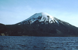
At about 1000 on 28 August pilots Charles Kozler, Wayne Russell, and George Wooliver (Reeve Aleutian Airways) reported an eruption plume reaching 10.5 km altitude in the vicinity of Amukta, drifting WNW. The FAA issued a NOTAM warning pilots to stay 25 miles [40 km] from Amukta Island. Heavy weather clouds covered Amukta Island so its activity could not be directly observed. Mt. Cleveland, 100 km ENE, was apparently active that same morning and winds were blowing in the direction of Amukta (see Mt. Cleveland 12:08). The origin of the large cloud remains both uncertain and controversial at the time of this report.
On 4 September Wooliver observed a small dark ash plume rising at least 300 m above the summit of Amukta then drifting as much as 1 km NW. Only the NW flank was visible because of cloud cover. His observations were made from 9,750 m altitude from nearly 120 km N. Wooliver has flown in the Aleutian Islands since the 1950's and is experienced at observing eruptions.
Amukta's last known eruptive activity was on 12 July 1984 (BVE, no. 24). Harold Wilson (Peninsula Airways) notes that normal activity . . . is continuous minor steam emission from several small vents just inside the summit crater rim.
Geological Summary. The symmetrical Amukta stratovolcano lies in the central Aleutians SW of Chagulak Island and is the westernmost of the Islands of the Four Mountains group. The stratovolcano was constructed at the northern side of an arcuate caldera-like feature that is open to the sea along the southern coast of the 8-km-wide Amukta Island. It overlies a broad shield volcano and is topped by a 400-m-wide crater, and a cinder cone is located near the NE coast. There have been several reported eruptions from both summit and flank vents.
Information Contacts: T. Miller, USGS Anchorage; J. Reeder, ADGGS.