Report on Akutan (United States) — June 1988
Scientific Event Alert Network Bulletin, vol. 13, no. 6 (June 1988)
Managing Editor: Lindsay McClelland.
Akutan (United States) Ash and steam emission
Please cite this report as:
Global Volcanism Program, 1988. Report on Akutan (United States) (McClelland, L., ed.). Scientific Event Alert Network Bulletin, 13:6. Smithsonian Institution. https://doi.org/10.5479/si.GVP.SEAN198806-311320
Akutan
United States
54.134°N, 165.986°W; summit elev. 1303 m
All times are local (unless otherwise noted)
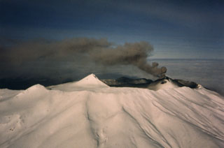
Ash and steam have been sporadically ejected from a cinder cone in the summit caldera since 1972. Recent periods of activity include June 1987 and March-June 1988 (table 4). Most of the observed activity is reported by airline pilots. Cloudy weather commonly obscures the view of the summit from the ground.
Table 4. Reports of activity at Akutan, 7 June-2 July 1988, compiled by John Reeder from the following observers: Clint Schoenleber, Terry Reece, Jerry Friz (Mark Air Inc.), Charles Rodehaver, Rick Wilbur, Buddy Burnett, Brian Carricaburu, Nick Sias (Peninsula Airways), Tom Madsen (Aleutian Air Ltd.), Steve Felch (Northern Air Cargo), david and June McGlashan, Charlotte Jones (Akutan village), and a member of the U.S. Coast Guard (USCG). Summit elevation, 1,303 m; all heights reported as meters above the summit. Observers initials in brackets.
| Date | Time | Activity [with observers] |
| 07-10 Jun | -- | No reports due to cloudy weather. |
| 10 Jun 1988 | 1237 | No activity [CS]. |
| 10 Jun 1988 | 1248 | White steam plume (300 m) [CS]. |
| 10 Jun 1988 | 1809 | Steam and sulfur plume (1,137 m) [TR]. |
| 11 Jun 1988 | 1210 | Dark ash emission (150 m) [CS]. |
| 11 Jun 1988 | 1348 | Small transparent ash-and-steam ejection (60 m) [JR, CR]. |
| 11 Jun 1988 | 1353 | Second ejection. The first rose 120 m and drifted S [JR, CR]. |
| 11 Jun 1988 | 1404 | A third minor ash-and-steam plume began to form [JR, CR]. |
| 12 Jun 1988 | -- | No reports due to rainy, windy weather. |
| 13 Jun 1988 | 1317 | No activity [CS]. |
| 14-16 Jun 1988 | -- | No activity [JR, RW]. |
| 17 Jun 1988 | 1638 | Column of dark ash (1,800 m) [JF]. |
| 19 Jun 1988 | 1204 | Thin column of dark ash (460 m) drifted 9 km W [CS]. |
| 19 Jun 1988 | 1322 | Minor ash [CR]. |
| 20 Jun 1988 | 1324 | Three thin columns of dark ash through 1354 (797 m) [BB]. |
| 20 Jun 1988 | 1511 | Steady ash emission (2,050 m) drifted NE 4-5.5 km [TM]. |
| 21 Jun 1988 | 1052 | Dark ash emission (600 m) [unknown]. Fog at village until 1900. |
| 21 Jun 1988 | 1900 | Two large ash eruptions through 1940 [CJ and villagers]. |
| 22 Jun 1988 | 2351 | Thick, black ash plume (200 m) drifted 9-18 km SE [BC]. |
| 23-27 Jun 1988 | -- | Mostly good weather. No activity. |
| 28 Jun 1988 | 1316 | Steam-and-ash plume (1,000-1,500 m) drifted W [SF]. |
| 28 Jun 1988 | 1530 | Small ash plume (300-600 m) [USCG]. |
| 29 Jun 1988 | -- | Nearly continuous ash and steam emissions with minor "puffs" throughout the day [DM and villagers]. |
| 29 Jun 1988 | 1430 | Large, gray ash emission (400 m) lasted several minutes and drifted SE [JM from village]. |
| 30 Jun 1988 | 1420 | Mild ash emissions (450-600 m) [DM]. |
| 01 Jul 1988 | a.m. | Grayish-white cloud ("haze") seen from Akutan Harbor deposited a small amount of ash on the village [DM]. |
| 02 Jul 1988 | 1030 | Black ash plume drifted horizontally 8 km NW through 1045 [NS]. |
Geological Summary. Akutan contains a 2-km-wide caldera with a large cinder cone in the NE part of the caldera that has been the source of frequent explosive eruptions and occasional lava effusion that covers the caldera floor. An older, largely buried caldera was formed during the late Pleistocene or early Holocene. Two volcanic centers are located on the NW flank. Lava Peak is of Pleistocene age, and a cinder cone lower on the flank produced a lava flow in 1852 that extended the shoreline of the island and forms Lava Point. The 60-365 m deep younger caldera was formed during a major explosive eruption about 1,600 years ago and contains at least three lakes. A lava flow in 1978 traveled through a narrow breach in the north caldera rim almost to the coast. Fumaroles occur at the base of the caldera cinder cone, and hot springs are located NE of the caldera at the head of Hot Springs Bay valley and along the shores of Hot Springs Bay.
Information Contacts: J. Reeder, ADGGS.