Report on Santa Maria (Guatemala) — November 1988

Scientific Event Alert Network Bulletin, vol. 13, no. 11 (November 1988)
Managing Editor: Lindsay McClelland.
Santa Maria (Guatemala) Continued lava extrusion & explosions; rainy season lahar damage moderate
Please cite this report as:
Global Volcanism Program, 1988. Report on Santa Maria (Guatemala) (McClelland, L., ed.). Scientific Event Alert Network Bulletin, 13:11. Smithsonian Institution. https://doi.org/10.5479/si.GVP.SEAN198811-342030
Santa Maria
Guatemala
14.757°N, 91.552°W; summit elev. 3745 m
All times are local (unless otherwise noted)
INSIVUMEH geologist Otoniel Matías reports that the dacite lava flow that extended 3.5 km SSW of the active Caliente vent by February 1988 (13:02) had stagnated there since February, although extrusion was continuing at a reduced rate. Geologists noted continuing small avalanches from the upper portion of the flow on 23 November. The middle portion of the block lava flow (about 1.5 km NNW of Mirador La Florida) was steaming, but remained stagnant. However a new lobe had advanced along the W margin of the flow to about 1.3 km from Caliente vent (figure 6).
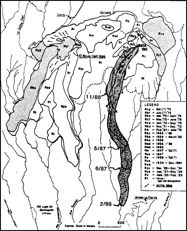 |
Figure 6. Map of Santiaguito Dome, showing the ages of its domes. The 1986-88 flow is emphasized by a shaded pattern; other recent lobes are stippled. Successive positions of the 1986-88 flow are dated, and the approximate November 1988 location of the new lobe is shown. Modified from Rose (1987). |
Small to moderate vertical explosions from the Caliente vent have continued. The number of explosions, as determined from field observations and seismic records from stations 5 km NNW and 2.6 km S of Santiaguito, has been tabulated by Matías since June (figure 7). Daily explosion totals during June ranged from 5 to 22. Activity decreased steadily through most of July, but increased again August-October, reaching a peak of 28 explosions on 19 October. Larger explosions produced steam and ash columns that rose 1-2 km above Caliente vent; secondary explosions to 400-1,000 m height occurred at roughly similar rates. The number of small block-and-ash avalanches from the active lava flow ranged from about 100 to 250/day in June and dropped to around 50-150/day in July, paralleling the drop in explosion frequency. From August through October the daily number of avalanches ranged from about 100 to over 300.
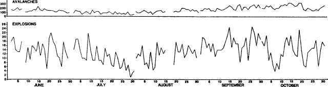 |
Figure 7. Number of daily explosions (bottom) and an extrapolation of the number of daily avalanche events (top) recorded by seismic stations near Santiaguito, June-October 1988. Field observations of eruptive phenomena were correlated with records from a portable seismograph to identify their seismic signatures. Courtesy of Otoniel Matías. |
The sediment load from Santiaguito has continued to impact downslope river drainages, but the effects of the 1988 rainy season were relatively mild compared to past years. The El Palmar area was observed in November to be essentially unchanged from February, as the Río Nimá II remained contained within perched levees above the town. However, downstream lahars destroyed the supports of an important foot suspension bridge across the Río Samalá below San Felipe, about 14 km SSW of Santiaguito (figure 8); reconstruction of this bridge was continuing in November. The Carretera Internacional del Pacífico (CA2) below Santa Cruz Muluá was closed briefly in late August and around 4-5 September as floods deposited sand and gravel over a 150-m section of the highway. The Río Samalá was again diverted by rainy season lahars into the Río Ixpatz drainage, innundating portions of the Finca San José La Granja (about 5 km S of the sharp bend in route CA2). This diversion of river courses into parallel drainages has occured each year since 1983. The annual construction of barriers to return the Samalá to its normal course had not been completed in November. The Samalá also partially diverted the Río Muluá to the east.
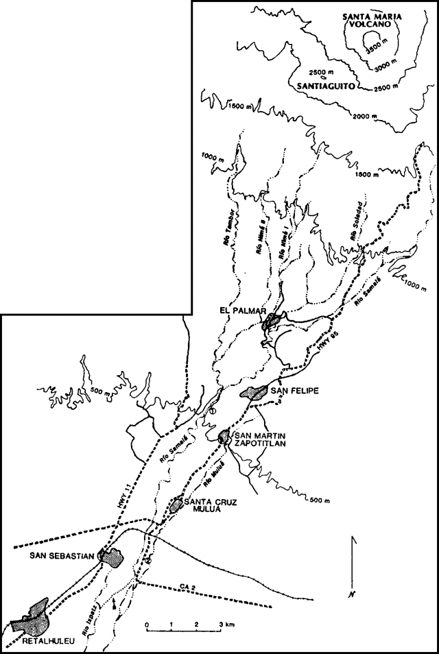 |
Figure 8. Sketch map of rivers and towns S of Santiaguito, modified from a February 1988 sketch by William Rose. Locations of drainages are approximate. Arrows mark the location of the diversion of the Río Samalá into the Río Ixpatz and the former confluence of Ríos Nimá I and II near El Palmar. Points 1 and 2 indicate the damaged bridge below San Felipe and the flooded segment of route CA2. |
Geological Summary. Symmetrical, forest-covered Santa María volcano is part of a chain of large stratovolcanoes that rise above the Pacific coastal plain of Guatemala. The sharp-topped, conical profile is cut on the SW flank by a 1.5-km-wide crater. The oval-shaped crater extends from just below the summit to the lower flank, and was formed during a catastrophic eruption in 1902. The renowned Plinian eruption of 1902 that devastated much of SW Guatemala followed a long repose period after construction of the large basaltic andesite stratovolcano. The massive dacitic Santiaguito lava-dome complex has been growing at the base of the 1902 crater since 1922. Compound dome growth at Santiaguito has occurred episodically from four vents, with activity progressing E towards the most recent, Caliente. Dome growth has been accompanied by almost continuous minor explosions, with periodic lava extrusion, larger explosions, pyroclastic flows, and lahars.
Information Contacts: Otoniel Matías and Enrique Molina, INSIVUMEH; Jim Vallance, Michigan Tech; Lee Siebert, SI.