Report on Witori (Papua New Guinea) — 29 August-4 September 2007
Smithsonian Institution / US Geological Survey
Weekly Volcanic Activity Report, 29 August-4 September 2007
Managing Editor: Sally Sennert.
Please cite this report as:
Global Volcanism Program, 2007. Report on Witori (Papua New Guinea) (Sennert, S, ed.). Weekly Volcanic Activity Report, 29 August-4 September 2007. Smithsonian Institution and US Geological Survey.
Witori
Papua New Guinea
5.5745°S, 150.5161°E; summit elev. 724 m
All times are local (unless otherwise noted)
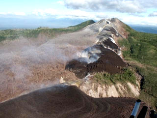
Based on a report from Kimbe Vulcanological Observatory (KVO), RVO reported that people from villages near Pago heard a single booming noise and saw an increase in white vapor emission on 27 August. Seismicity increased during 27-28 August. The second crater of the upper vents ejected lava fragments on 28 August. White vapor emitted from the same crater was seen during an inspection of the area on 29 August.
Geological Summary. The active Pago cone has grown within the Witori caldera (5.5 x 7.5 km) on the northern coast of central New Britain contains the active Pago cone. The gently sloping outer caldera flanks consist primarily of dacitic pyroclastic-flow and airfall deposits produced during a series of five major explosive eruptions from about 5,600 to 1,200 years ago, many of which may have been associated with caldera formation. Pago cone may have formed less than 350 years ago; it has grown to a height above the caldera rim, and a series of ten dacitic lava flows from it covers much of the caldera floor. The youngest of these was erupted during 2002-2003 from vents extending from the summit nearly to the NW caldera wall. The Buru caldera cuts the SW flank.
Source: Rabaul Volcano Observatory (RVO)