Report on San Vicente (El Salvador) — 4 November-10 November 2009
Smithsonian Institution / US Geological Survey
Weekly Volcanic Activity Report, 4 November-10 November 2009
Managing Editor: Sally Sennert.
Please cite this report as:
Global Volcanism Program, 2009. Report on San Vicente (El Salvador) (Sennert, S, ed.). Weekly Volcanic Activity Report, 4 November-10 November 2009. Smithsonian Institution and US Geological Survey.
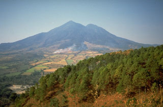
San Vicente
El Salvador
13.5969°N, 88.8375°W; summit elev. 2149 m
All times are local (unless otherwise noted)
According to news articles, heavy rains caused landslides and flooding in the town of Verapaz, about 6 km NW of the summit of San Vicente, during 7-8 November. Mud and boulders swept down the flanks San Vicente, and in conjunction with flooded rivers, buried homes and cars; at least 144 people were killed and about 60 were missing.
Geological Summary. San Vicente stratovolcano, also known as Chichontepec, is ~20 km SE of Lake Ilopango. The andesitic edifice with two summit peaks was constructed within the Pleistocene La Carbonera caldera, whose rim is visible only on its SW side. The N and S flanks are covered by lava flows from the central vent, but lava flows on the eastern side originated from a vent on the upper flank. Volcanism has continued into the Holocene, but the latest lava flows are covered by deposits from the major Tierra Blanca eruption from Ilopango around 450 CE. Reports of eruptions in 1643 CE and 1835 CE are false (Catalog of Active Volcanoes of the World; Sapper, 1917), but numerous hot springs and fumaroles are found on the N and W flanks.
Sources: Associated Press, Associated Press