Report on Rasshua (Russia) — 6 February-12 February 2013
Smithsonian Institution / US Geological Survey
Weekly Volcanic Activity Report, 6 February-12 February 2013
Managing Editor: Sally Sennert.
Please cite this report as:
Global Volcanism Program, 2013. Report on Rasshua (Russia) (Sennert, S, ed.). Weekly Volcanic Activity Report, 6 February-12 February 2013. Smithsonian Institution and US Geological Survey.
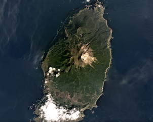
Rasshua
Russia
47.77°N, 153.02°E; summit elev. 956 m
All times are local (unless otherwise noted)
SVERT reported that a thermal anomaly over Rasshua was detected in satellite images on 6 February.
Geological Summary. The elongated 6 x 13 km island of Rasshua in the central Kuriles contains three overlapping central cones within a 6 km caldera whose eastern margin is beyond the shoreline. An eroded central cone was constructed during the late Pleistocene, along with an isolated cone near the NW coast. Two Holocene cones were built within the crater of the central cone. The westernmost forms the 956 m high point of the island and is the source of lava flows that flooded the crater floor and descended to the coast. The easternmost cone, active during historical time, is truncated by a 500-m-wide crater that is breached to the SE. This crater may have formed during a violent eruption in 1846. The only other known historical eruption produced weak explosions in 1957. Fumarolic activity continues in the eastern crater and in the saddle between the two summit cones.