Report on Askja (Iceland) — 10 September-16 September 2014
Smithsonian Institution / US Geological Survey
Weekly Volcanic Activity Report, 10 September-16 September 2014
Managing Editor: Sally Sennert.
Please cite this report as:
Global Volcanism Program, 2014. Report on Askja (Iceland) (Sennert, S, ed.). Weekly Volcanic Activity Report, 10 September-16 September 2014. Smithsonian Institution and US Geological Survey.
Askja
Iceland
65.033°N, 16.783°W; summit elev. 1080 m
All times are local (unless otherwise noted)
IMO had maintained the Aviation Colour Code for Askja at Yellow since 28 August due to elevated seismicity and localized deformation. On 11 September the Colour Code was reduced to Green when seismicity had diminished significantly.
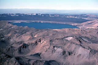
Geological Summary. Askja is a large basaltic central volcano that forms the Dyngjufjöll massif. It is truncated by three overlapping calderas, the largest of which is 8 km wide and may have been produced primarily from subglacial ring-fracture eruptions rather than by subsidence. A major rhyolitic explosive eruption from Dyngjufjöll about 10,000 years ago was in part associated with the formation of Askja caldera. Many postglacial eruptions also occurred along the ring-fracture. A major explosive eruption on the SE caldera margin in 1875 was one of Iceland's largest during historical time. It resulted in the formation of a smaller 4.5-km-wide caldera, now filled by Öskjuvatn lake, that truncates the rim of the larger central caldera. The 100-km-long Askja fissure swarm, which includes the Sveinagja graben, is also related to the Askja volcanic system, as are several small shield volcanoes such as Kollatadyngja. Twentieth-century eruptions have produced lava flows from vents located mostly near Öskjuvatn lake.