Report on Kadovar (Papua New Guinea) — 3 January-9 January 2018
Smithsonian Institution / US Geological Survey
Weekly Volcanic Activity Report, 3 January-9 January 2018
Managing Editor: Sally Sennert.
Please cite this report as:
Global Volcanism Program, 2018. Report on Kadovar (Papua New Guinea) (Sennert, S, ed.). Weekly Volcanic Activity Report, 3 January-9 January 2018. Smithsonian Institution and US Geological Survey.
Kadovar
Papua New Guinea
3.608°S, 144.588°E; summit elev. 365 m
All times are local (unless otherwise noted)
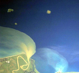
The first confirmed historical eruption at Kadovar began around mid-day local time on 5 January, according to witnesses. The island is approximately 1.4 km in diameter with very steep slopes, located about 25 km NNE from the mouth of the Sepik River on the New Guinea mainland. The Rabaul Volcanological Observatory (RVO) warned of potential explosive activity, landslides, and resulting possible tsunamis.
Aerial photos and observations from Samaritan Air flights showed dark gray ash and steam plumes rising from a crater on the SE side of the summit. It was estimated that up to 60% of the island was covered in volcanic products, which primarily appeared to be ash along with some pyroclastic flows. Ashfall was reported on Kairiru and Mushu islands (115 km WNW), Mt. Uru in Yangoru (130 km W), and Woginara (140 km W), along with locations along the W coast of the Wewak District.
The NOAA/CIMSS Volcanic Cloud Monitoring system generated an alert for the ash cloud moving WNW, as imaged by S-NPP VIIRS at 0330 UTC on 5 January; Himawari-8 imagery subsequently showed that the eruption began around 0220 UTC. The Darwin VAAC issued a sequence of ash advisories starting on 5 January that noted ash moving W at an altitude of about 2.1 km (7,000 ft) a.s.l., and set the Aviation Color Code to Orange. Both discrete eruptions and continuous ongoing activity was seen in satellite imagery through 9 January, with the plume visible at distances of over 200 km W and WNW.
Although initial news reports regarding the population and evacuation status were unclear, the East Sepik Governor, Allan Bird, told media on 8 January that 591 residents of Kadovar had been evacuated to Blup Blup island (about 10 km N) due to the organizational efforts of village councilors on the two islands.
RVO stated that during 7-8 January ash continued to be emitted, and blown tens of kilometers WNW.
Geological Summary. The 2-km-wide island of Kadovar is the emergent summit of a Bismarck Sea stratovolcano of Holocene age. It is part of the Schouten Islands, and lies off the coast of New Guinea, about 25 km N of the mouth of the Sepik River. Prior to an eruption that began in 2018, a lava dome formed the high point of the andesitic volcano, filling an arcuate landslide scarp open to the south; submarine debris-avalanche deposits occur in that direction. Thick lava flows with columnar jointing forms low cliffs along the coast. The youthful island lacks fringing or offshore reefs. A period of heightened thermal phenomena took place in 1976. An eruption began in January 2018 that included lava effusion from vents at the summit and at the E coast.
Sources: Rabaul Volcano Observatory (RVO), Loop, Darwin Volcanic Ash Advisory Centre (VAAC), NOAA Cooperative Institute for Meteorological Satellite Studies