Report on Hunga Tonga-Hunga Ha'apai (Tonga) — 19 January-25 January 2022
Smithsonian Institution / US Geological Survey
Weekly Volcanic Activity Report, 19 January-25 January 2022
Managing Editor: Sally Sennert.
Please cite this report as:
Global Volcanism Program, 2022. Report on Hunga Tonga-Hunga Ha'apai (Tonga) (Sennert, S, ed.). Weekly Volcanic Activity Report, 19 January-25 January 2022. Smithsonian Institution and US Geological Survey.
Hunga Tonga-Hunga Ha'apai
Tonga
20.5532°S, 175.3841°W; summit elev. 114 m
All times are local (unless otherwise noted)
No additional eruptive events were detected at Hunga Tonga-Hunga Ha'apai after the large and explosive eruption on 15 January. The gas, steam, and ash plume produced during that eruption rose into the stratosphere and drifted W. Based on volcanic ash advisories issued by the Wellington VAAC and then by the Darwin VAAC, the horizontal extent of the plume grew from 18,000 square kilometers at 1739 on 15 January to 12 million square kilometers by 1300 on 19 January. The plume narrowed and lengthened along an E-W axis, moving W over Australia. The Aviation Color Code was lowered to Green on 19 January. According to the Darwin VAAC the plume continued to drift W at altitudes between 12.8 and 19.2 km (42,000 and 63,000 ft) a.s.l. during 19-22 January; the ash was diffuse and difficult to distinguish from meteorological clouds, though the sulfur dioxide signal was stronger. By 22 January the leading-edge of the plume had reached the E coast of Africa. By 2150 the Darwin VAAC noted that ash was no longer detectable.
Tsunami waves generated by the 15 January eruption caused an oil spill near at the La Pampilla refinery along Peru’s coast, affecting a 38-km-stretch of beach from Ventanilla to Peralvillo Beach in Chancay, according to Peru’s Agency for Environmental Assessment and Enforcement (OEFA). An estimated 6,000 barrels of oil were spilled, significantly impacting an estimated 180 hectares of beach, almost 715 hectares of ocean, and local fisherman.
In a media release on 21 January, the Government of Tonga reported that ashfall and tsunami had damaged all islands. International humanitarian aid had reached the islands the day before, five days after the eruption ceased. Inter-island and international communication remained challenging though was partially restored; a relief flight from New Zealand brought telecommunication equipment and a repair vessel was en-route to the damaged seafloor fiber-optic cable. Floating debris, likely including pumice, hindered sea transportation. Domestic flights remained suspended, though international flights carrying relief supplies were able to land and aerial surveys of damage were conducted. According to a social media post from 23 January residents swept ash off of a Salote Pilolevu Airport runway in Ha’apai. News reports shared stories of survivors and showed images of damage around the islands.
Dozens of earthquakes, M 4.5-5, were centered in the vicinity of the volcano after the eruption, at least through 24 January. The type of earthquake signal was unknown, though they likely represented post-eruption movement along existing faults and not magma movement.
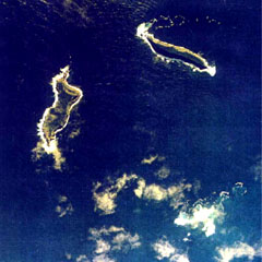
Geological Summary. The small andesitic islands of Hunga Tonga and Hunga Ha'apai are part of the western and northern remnants of the rim (~6 km diameter) of a largely submarine caldera located about 30 km SSE of Falcon Island. The topmost sequence of welded and unwelded ignimbrite units from a caldera-forming eruption was 14C dated to 1040-1180 CE (Cronin et al., 2017; Brenna et al. 2022). At least two additional welded pumice-rich ignimbrite units and nonwelded pyroclastic flow deposits, below paleosols and other volcaniclastic deposits, indicated more very large previous eruptions (Cronin et al., 2017; Brenna et al. 2022). Several submarine eruptions have occurred at this caldera system since the first recorded eruption in 1912, including 1937 and S of the islands in 1988. A short eruption in 2009 added land to to Hunga Ha'apai. At that time the two islands were each about 2 km long, displaying inward-facing sea cliffs with lava and tephra layers dipping gently away from the caldera. An eruption during December 2014-January 2015 was centered between the islands, and combined them into one larger structure. Major explosive eruptions in late 2021 initially reshaped the central part of the combined island before stronger activity in mid-January 2022 removed most of the 2014-15 material; an even larger eruption the next day sent an eruption plume high into the stratosphere, triggered shock waves through the atmosphere and tsunami across the Pacific Ocean, and left only small remnants of the islands above the ocean surface.
Sources: Josephine Latu-Sanft, Brisbane Times, Consulate of the Kingdom of Tonga, Judith Hubbard, Matangi Tonga Online, Wellington Volcanic Ash Advisory Center (VAAC), Darwin Volcanic Ash Advisory Centre (VAAC), Advanced geospatial Data Management Platform (ADAM), National Public Radio (NPR), Dov Bensimon, Montréal Volcanic Ash Advisory Centre (VAAC), Simon Carn, Agency for Environmental Assessment and Enforcement (OEFA), Peru, Andina Agencia Peruana de Noticias, US Geological Survey Earthquake Hazards Program