Global Volcanism Program | Image GVP-11093

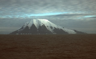
Glaciers descend the steep southern face of Visokoi Island from the flat-topped summit of Mount Hodson. Wordie Point (left) and Irving Point (right) lie respectively at the west and east sides of the 5.5 x 7 km wide island. The sea cliffs comprise interbedded lavas and pyroclastics. The cliffs at Wordie Point are formed by thick columnar-jointed lavas. Numerous basaltic scoria cones were constructed on the lower flanks of the island, including at Irving Point, and are thought to represent the most recent activity.
Photo by John Smellie (British Antarctic Survey).
![]() This image is made available under the Creative Commons BY-NC 4.0 license terms.
This image is made available under the Creative Commons BY-NC 4.0 license terms.
Keywords: stratovolcano
Hodson