Global Volcanism Program | Image GVP-11181

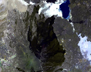
Alayta shield volcano (left-center) covers an area of 2,700 km2 in the western Danakil depression. A series of recent craters is aligned along the NNW-trending axis. The Alayta lava field (center dark area) was erupted from N-S-trending fissures along the E side of the volcano and reaches the W flank of Afderà volcano, immediately S of Lake Guilietti (Lake Afrera) at the upper right-center.
NASA Landsat image, 1999 (courtesy of Hawaii Synergy Project, Univ. of Hawaii Institute of Geophysics & Planetology).
![]() This image is made available as a Public Domain Work, but proper attribution is appreciated.
This image is made available as a Public Domain Work, but proper attribution is appreciated.
Keywords: remote sensing | lava flow | shield volcano
Alayta