Global Volcanism Program | Image GVP-11568

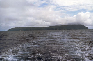
The low profile of Isla del Coco is seen from the NE, taken from the R/V Searcher of the University of Costa Rica. The 22 km2 rain-drenched island was discovered by the Spanish pilot Juan Cabezas around 1526 CE, and the Costa Rican flag was first planted on the island in 1869. Isla del Coco is the only subaerial portion of the Cocos Ridge, which extends from the Galápagos hot spot to the Mesoamerican trench. Construction of a Pliocene-Pleistocene shield volcano was followed by caldera formation and the emplacement of a trachytic lava dome.
Photo by Pat Castillo, 1984 (Scripps Institution of Oceanography, University of California San Diego).
![]() This image is made available under the Creative Commons BY-NC-ND 4.0 license terms.
This image is made available under the Creative Commons BY-NC-ND 4.0 license terms.
Isla del Coco