Global Volcanism Program | Image GVP-12353

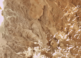
The Cerro Bayo volcanic complex is along the Chile-Argentina border east of the Salar de Gorbea and is shown in this 21 October 2019 Planet Scope satellite image (N is at the top; the image is approximately 11.5 km across). A 430-m-diameter crater is visible at the summit of a scoria cone, and to the W are lobate lava flows with levees and pressure ridges.
Satellite image courtesy of Planet Labs Inc., 2019 (https://www.planet.com/).
Copyrighted image used with permission. All Rights Reserved. Contact photographer for any usage requests.
Galleries: Lava Flows
Cerro Bayo Gorbea