Keyword Collections | Keyword "levee"
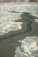 The chemically exotic lavas of Tanzania's Ol Doinyo Lengai volcano have unusually low temperatures and viscosities; it is the only volcano actively erupting carbonatitic (sodium carbonate) lava flows. Its lava flows are only incandescent during nighttime. The flows are usually only a few centimeters thick and travel only a few tens of meters from their source. This 1966 photo shows a small lava flow, only a meter wide, with miniature channels and levees (note the person at the top for scale).
Photo by Gordon Davies, 1966 (courtesy of Celia Nyamweru, Kenyatta University).
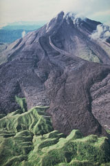 Bagana volcano, on Papua New Guinea's Bougainville Island, is characterized by the extrusion of thick, viscous andesitic lava flows. This photo shows a large lava flow with prominent lateral levees descending from the summit and ponding against forested hills at the base of the volcano. Bagana is constructed almost entirely of overlapping lava-flow lobes. Slow lava extrusion, occasionally accompanied by explosive activity, has been common since the mid-1800s.
Photo by Wally Johnson, 1988 (Australia Bureau of Mineral Resources).
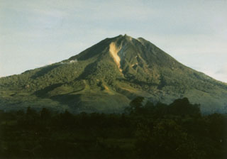 Sinabung volcano, seen here from Tigapancur village, is a prominent stratovolcano on the Karo Plateau in NW Sumatra. Levees of large lava flows (left-center) are prominent on the flanks of the volcano. At the time that this photo was taken in 1982, no confirmed historical eruptions were known.
Photo by S. Wikartadipura, 1982 (Volcanological Survey of Indonesia).
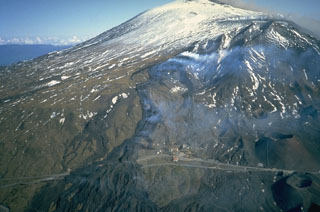 Black lava flows descend the south flank of Etna a week after the eruption began on 28 March 1983 and went on to last for five months. Prominent levees are visible on the surface of the lava flows that crossed a highway and formed a complex lava field as much as 1 km wide. The flows originated from a NNE-SSW-trending fissure 4 km S of Etna's snow-capped Central Crater.
Photo by Romolo Romano, 1983 (IIV-CNR, Catania, Italy).
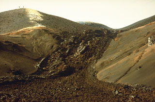 A lava flow from the April-August 1989 eruption on the east flank of Nyamuragira is seen in this December 1989 view. Low levees bank against the side of the cone. People on the cone on the left horizon provide scale.
Photo by Henry-Luc Hody, 1989 (Belgian ambassador).
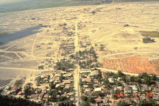 Lahars produced devastating social and economic disruption for many years after the 1991 eruption of Pinatubo in the Philippines. The towns of Barangay Manibaug Pasig in the foreground of this 26 February 1994 view, and Mancatian in the distance, were progressively buried over several years. Construction of lahar levees provided only temporary protection from the massive downstream redistribution of ash and pumice from the 1991 eruption.
Photo by Ray Punongbayan, 1994 (Philippine Institute of Volcanology and Seismology).
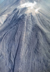 Lava flows, many with prominent marginal levees, descend the W flank of Moyorodake. This is one of four cones constructed along an NE-SW line and it has two shallow craters. The western crater has produced a thick lava flow and numerous other lava flows that form the flanks of the cone and extend 2-3 km. This cone had eruptions in 1778 or 1779, 1883, and 1958.
Photo by T. Vendelin, 1990 (courtesy of Genrich Steinberg, Institute for Marine Geology and Geophysics, Yuzhno-Sakhalinsk).
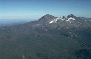 An aerial view from the NW shows North Sister (center) and Middle Sister (right) with young lava flows from N-flank scoria cones. The latest dated lava flow originated about 1,600 years ago from Collier Cone, near the center of the photo below the left flank of North Sister. One lava flow lobe traveled to the NW and levees on the western lobe are visible in the right foreground. They western lobe traveled 13.5 km down the White Branch Creek valley.
Photo by Dan Miller, 1977 (U.S. Geological Survey).
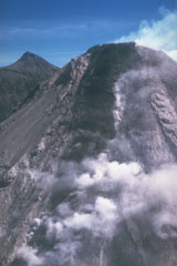 A lava flow advances down the steep upper SW flank of Colima in 1991. Aerial observations revealed lateral levees, pressure ridges near the flow front, and a lava channel within which most of the flow was advancing. The flow was about 100 m wide, 30 m thick, and 300 m long at the time of this 20 April 1991 photograph. Renewed lava extrusion took place following the partial collapse of the summit dome on 16 April. Nevado de Colima is in the background.
Photo by Juan Manuel Espíndola, 1991 (Universidad Nacional Autónoma de México).
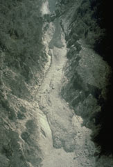 This 24 April 1991 aerial photo shows deposits from the 1991 eruption of Colima in the lower part of the Barranca El Cordobán on the south flank. The deposits at the bottom of the photo with rounded flow fronts and well-defined levees originated from block-and-ash flows. The darker, more recent deposits near the top of the photo contain a higher amount of juvenile (fresh magmatic) material.
Photo by Jean-Christophe Komorowski, 1991(Arizona State University).
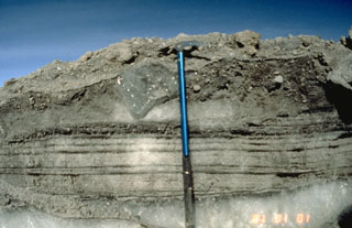 A record of the 13 November 1985 eruption of Nevado de Ruiz was preserved in ice-rich levees of pyroclastic flows. This photo, taken a month later, shows parallel-bedded pyroclastic-surge deposits, composed of snow grains and tephra, which were deposited over a pre-existing ice at the bottom of the photo. The surge layers are overlain at the top by coarser-grained pyroclastic-flow deposits. The clast of glacial ice (located left of the upper part of the ice axe) was scoured and incorporated into the pyroclastic flow.
Photo by Tom Pierson, 1985 (U.S. Geological Survey).
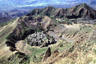 The small lava dome on the floor of the crater in the foreground was emplaced late in the 1870-75 eruption of Ceboruco. Levees of a lava flow that traveled 6.5 km down the west flank are higher than this crater, indicating that the main 1870 vent that fed the flows was probably located above the dome. The ridge to the upper right is the NW rim of the outer caldera.
Photo by Lee Siebert, 1997 (Smithsonian Institution).
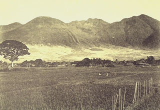 The prominent levees of a historical lava flow (center) are visible on the SE flank of Guntur. The rounded summit at the left is Gunung Guntur, the youngest peak of the volcanic complex. To the right are Gunung Batususun and Gunung Picung, part of the older massif.
Photo published in Taverne, 1926 "Vulkaanstudien op Java," (courtesy of Volcanological Survey of Indonesia).
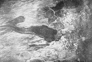 Lava flows, some of historical age, on the SE flank of Guntur volcano, encroaching on cultivated fields. Prominent flow levees are visible on the youngest lava flow that was emplaced over levees of older flows.
Photo published in Taverne, 1926 "Vulkaanstudien op Java," (courtesy of Volcanological Survey of Indonesia).
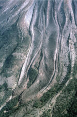 Two parallel lava lobes with lateral levees were emplaced in the Cordoban drainage on the SW flank of Colima, seen here on 8 February 1999. The flows are partly confined within levees of older lava flows. Lava extrusion had begun from the summit lava dome on 20 November 1998 and quickly produced a flow that split into three lobes as it diverged around topographic highs on the upper flanks.
Photo by Jim Luhr, 1999 (Smithsonian Institution).
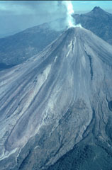 A helicopter view of Colima volcano towards the north on 8 February 1999 shows the degassing lava dome and active lava flows with Nevado de Colima in the background. A single flow originated from the summit dome, but the light-colored topographic high on the upper SW flank caused it to split into separate lobes. The easternmost lobe can be seen here descending diagonally to the lower left. The lava flow from 1991 was completely covered by this new flow.
Photo by Jim Luhr, 1999 (Smithsonian Institution).
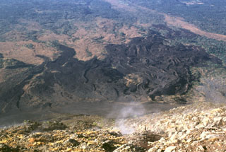 A lava flow field on the SW flank of Izalco is seen here from its summit. Levees define distinct flows of the lava field, which extends up to about 7 km from the summit. Most of the flows seen here were emplaced prior to 1954. Gas rises from fumaroles near the summit.
Photo by Lee Siebert, 1999 (Smithsonian Institution).
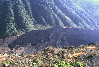 The lava flows with levees in the center of the photo were extruded from a vent on the NE flank of Izalco beginning in 1955. This lava extrusion took place during an almost continuous period of Strombolian activity from November 1948 until the end of 1957. Periods of lava effusion took place July 1950, September-November 1952, October 1954, intermittently in 1955, November 1956, and January 1957. The eruption tapered off in late 1957 and was over by the end of the year.
Photo by Lee Siebert, 1999 (Smithsonian Institution).
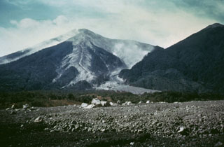 Hot pyroclastic flow deposits from the 1974 eruptions fill barrancas on the eastern flanks of Fuego. The deposit was the northeastern-most produced during the eruptions. Large blocks in the foreground were emplaced near the terminus of the deposit. The light-colored pyroclastic deposits extending from the summit are confined within levees with broader surge deposits that overtopped them.
Photo by Greg Hahn, 1974 (courtesy of Bill Rose, Michigan Technological University).
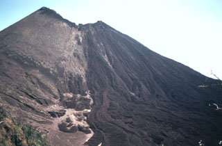 In May 1981 lava flows overtopped a notch in the NW rim of MacKenney crater and flowed down the northern flank. This view from Meseta on the caldera rim shows multiple individual flow lobes with levees. The dark lava field to the right contrasts with the tephra-covered slopes of the cone to the left. This period of frequent lava extrusion lasted from 9 May until 2 June.
Photo by Bill Rose, 1981 (Michigan Technological University).
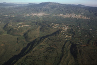 The large, steep-sided Xicomulco lava flow descends from the flanks of the Sierra Chichinautzin into the Valley of Mexico. The viscous lava flow averages 75 m in thickness, displays prominent flow levees, and traveled 4.5 km north. The flow was extruded with very little explosive activity and the vent was subsequently filled in and is now overlain by the town of San Bartolo Xicomulco (right-center). In the background is the town of San Pablo Oztotepec. Volcán Tlaloc is the broad volcano in the center of the horizon.
Photo by Gerardo Carrasco-Núñez, 1997 (Universidad Nacional Autónoma de México).
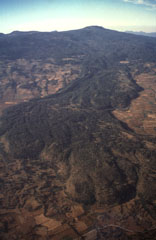 Volcán Tláloc, the broad volcano on the horizon, is one of the larger volcanic centers of the eastern part of the Chichinautzin volcanic field. It erupted about 6,200 years ago and is seen here from the east with a large lava flow in the foreground.
Photo by Hugo Delgado, 1994 (Universidad Nacional Autónoma de México).
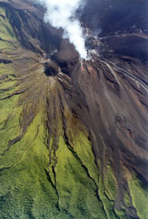 An active lava flow with small plumes rising from the margins can be seen at the upper right descending the Arenal NNW flank from the degassing Crater C complex on 29 June 1999. Below it, descending diagonally NE to the lower right, is another recent flow with clear lateral levees. The inactive crater to the left is Crater D, the pre-1968 summit crater.
Photo by Federico Chavarria Kopper, 1999 (courtesy of Eduardo Malavassi, OVSICORI-UNA).
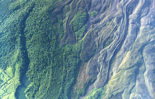 Lobate lava flows were emplaced down the northern flank of Arenal. Note the prominent flow levees and several kipukas (islands of forested land surrounded by lava flows). The eruption that began in 1968 covered much of the northern flank with lava flows. The lake at the lower left is named Peñaranda and lies at the edge of cultivated lands encroaching on the flanks.
Photo by Federico Chavarria Kopper, 1999 (courtesy of Eduardo Malavassi, OVSICORI-UNA).
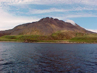 Amak, the easternmost of the Aleutian Islands, lies north of the tip of the Alaskan Peninsula. Like Bogoslof, it lies north of the main Aleutian volcanic front. Lava flows with prominent levees were emplaced in historical eruptions during 1700-1710 and in 1796.
Photo by Dave Roseneau, 2001 (U.S. Fish and Wildlife Service).
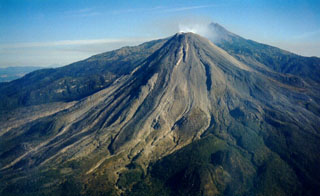 An aerial view of Colima's SW flank on 11 March 1999 shows recently erupted lava flows with lateral levees. Nevado de Colima appears to the right of the Volcán de Colima summit. Intermittent ash eruptions beginning in 1997 were followed by lava effusion, dome growth, pyroclastic flows, and more powerful explosive eruptions a year later.
Photo by Juan Carlos Gavilanes, 1999 (Colima Volcano Observatory, University of Colima).
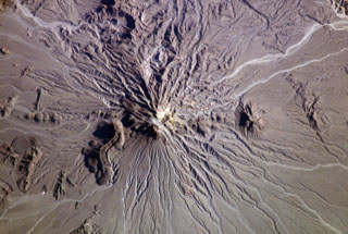 The Bazman (Kuh-e Bazman) volcano is located in remote SE Iran. A well-preserved, 500-m-wide crater caps the summit. Lava domes have been the source of viscous lava flows, including the prominent flow with visible flow levees at the lower left. No historical eruptions are known, but minor fumarolic activity has been reported.
NASA International Space Station image ISS006-E-5209, 2002 (http://eol.jsc.nasa.gov/).
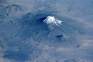 Glacier-clad Mount Ararat, seen in this NASA International Space Station image, is Turkey's highest, largest volume, and easternmost volcano. Kucuk Ararat (or Lesser Ararat) lies across a saddle to the SE (right-center). Prominent lava flows with flow levees were erupted from flank vents between Greater and Lesser Ararat; one of these terminates in a fan-shaped lobe at the lower left. Pyroclastic-flow deposits from Ararat overlie early Bronze Age artifacts.
NASA International Space Station image ISS002-E-10032, 2001 (http://eol.jsc.nasa.gov/).
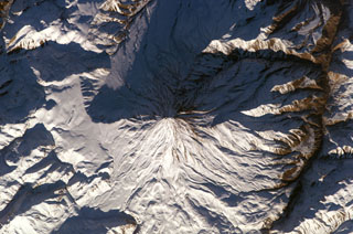 Winter snows highlight morphological features of Damavand volcano in this NASA International Space Station image (N to the upper left). Lava flows with prominent levees can be seen at the bottom of the image and a small well-preserved crater can be seen at the summit. The volcano is located about 80 km NE of the capital city of Tehran.
NASA International Space Station image ISS010-E-13393, 2005 (http://eol.jsc.nasa.gov/).
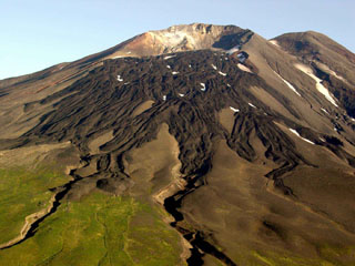 Gareloi in the western Aleutian Islands is seen here from the S. This photo shows lava flows with clear levees from a 1980s eruption. The 8 x 10 km diameter Gareloi Island consists of a stratovolcano with two peaks and a SE-trending fissure that formed during a 1929 eruption and extends to the sea.
Photo by Game McGimsey, 2003 (Alaska Volcano Observatory, U.S. Geological Survey).
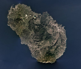 Pantelleria is a volcanic island 95 km west of Sicily and is composed of scoria cones, lava domes, lava flows, explosive eruption deposits, and calderas, with the Cinque Denti caldera rim visible in the right side of this 2019 satellite image (N is to the top). The 330 x 360 m crater near the center is within the summit of Monte Gibele, and lava flows with visible flow levees form the flanks. Montagne Grande is to the west (left) of the crater.
Satellite image courtesy of Planet Labs Inc., 2019 (https://www.planet.com/).
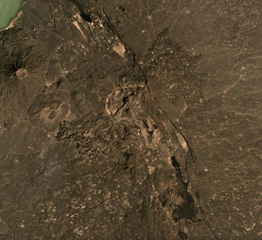 The Tat Ali volcanic complex is located within the NNW-SSE graben visible across this December 2019 Planet Labs satellite image mosaic (N is at the top) with Lake Afrera in the upper left corner. Lava flows have filled the graben, and lavas with flow ridges and levees can be seen near the center of this image. Borawli is the cone to the W, with a roughly 800-m-wide summit crater.
Satellite image courtesy of Planet Labs Inc., 2019 (https://www.planet.com/).
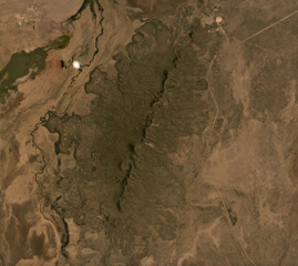 The Korath Range is the northernmost volcano of the Turkana rift in southern Ethiopia/northern Kenya. The central lineament of cones and craters has produced lava flows out to around 6 km from the vents. This September 2019 Planet Labs satellite image monthly mosaic shows the lobate flow margins and lateral flow levees and margins (N is at the top; this image is approximately 20 km across).
Satellite image courtesy of Planet Labs Inc., 2019 (https://www.planet.com/).
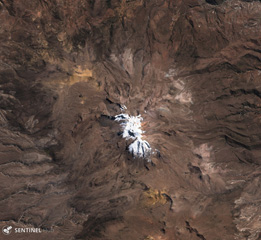 Glaciated Sara Sara volcano is in the center of this 22 July 2019 Sentinel-2 satellite image (N is at the top). A 15-km-long lava flow is visible on the eastern flank, with clear levees along the flow boundary. It is the westernmost young volcano in Peru and has produced intermittent explosive activity for less than 2 million years.
Satellite image courtesy of Copernicus Sentinel Data, 2019.
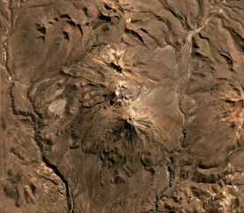 Volcán Yucamane is composed of three main edifices, Yucamane Chico to the N, El Calientes in the middle, and Volcán Yucamane at the southern end, seen in this July 2019 Planet Labs satellite image monthly mosaic (N is at the top; the image is approximately 19.5 km across). Levees and pressure ridges are visible on lobate lava flows on the flanks.
Satellite image courtesy of Planet Labs Inc., 2019 (https://www.planet.com/).
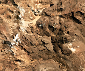 Four cones of the Nevados Casiri complex are seen in this July 2019 Planet Labs satellite image monthly mosaic (N is at the top; the image is approximately 11 km across). The three older cones are in a E-W trend, and the younger SE cone has a crater containing a dome along with two lava flows to the S and SE with visible levees and pressure ridges.
Satellite image courtesy of Planet Labs Inc., 2019 (https://www.planet.com/).
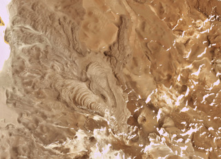 The Cerro Bayo volcanic complex is along the Chile-Argentina border east of the Salar de Gorbea and is shown in this 21 October 2019 Planet Scope satellite image (N is at the top; the image is approximately 11.5 km across). A 430-m-diameter crater is visible at the summit of a scoria cone, and to the W are lobate lava flows with levees and pressure ridges.
Satellite image courtesy of Planet Labs Inc., 2019 (https://www.planet.com/).
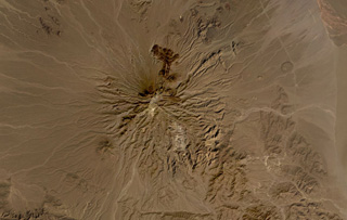 Bazman volcano is part of the Makran arc in SE Iran, shown here in this October 2019 Planet Labs satellite image monthly mosaic (N is at the top; this image is approximately 44 km across). Scoria cones and lava flows have formed across the eroded flanks, with several darker lava flows containing levees and lobate flow fronts visible on the northern flank. The Bazman granitoid complex forms part of the southern flank and formed between 83 and 72 million years ago.
Satellite image courtesy of Planet Labs Inc., 2019 (https://www.planet.com/).
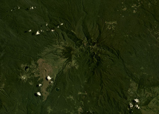 Ragang volcano in central Mindanao is in the center of this August 2019 Planet Labs satellite image monthly mosaic (N is at the top; this image is approximately 24 km across). Latukan is to the SW, past lava flows with visible levees and pressure ridges that appear to have erupted from flank vents.
Satellite image courtesy of Planet Labs Inc., 2019 (https://www.planet.com/).
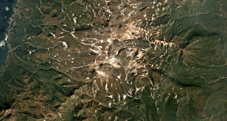 The Vernadskii Ridge in northern Paramushir Island is in the center of this September 2017 Planet Labs satellite image monthly mosaic (N is at the top; this image is approximately 22 km across). The ridge has three main volcano groups including the Vernadskii volcano group in the southern end, and the Bogdanovich volcano group 4-5 km north of that. A 3.5-km-long lava flow with levees and compression ridges was emplaced to the N then turned towards the E.
Satellite image courtesy of Planet Labs Inc., 2017 (https://www.planet.com/).
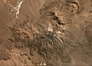 The flanks of Isluga volcano in Chile are formed by numerous lobate lava flows visible in this June 2019 Planet Labs satellite image monthly mosaic (N is at the top; this image is approximately 23 km across). The lavas have lateral levees and pressure ridges especially visible on the southern flanks. The most recent 400-m-diameter summit crater is visible at the western side of the summit area.
Satellite image courtesy of Planet Labs Inc., 2019 (https://www.planet.com/).
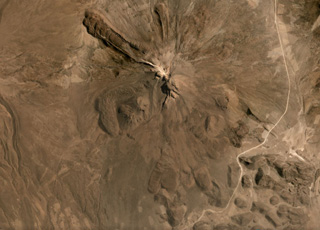 The flanks of Tata Sabaya have largely formed through the extrusion of lava domes and flows, with some lobate flows displaying pressure ridges and levees seen in this September 2019 Planet Labs satellite image monthly mosaic (N is at the top; this image is approximately 12 km across). The NW end of a hummocky roughly 300 km2 debris avalanche deposit is in the lower right corner of this image. The collapse scarp from the flank collapse that produced the deposit and opened toward the S has been subsequently filled by lava domes.
Satellite image courtesy of Planet Labs Inc., 2019 (https://www.planet.com/).
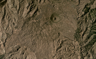 The Vaiyots-Sar scoria cone has a roughly 500-m-wide summit crater, seen in this August 2020 Planet Labs satellite image monthly mosaic (N is at the top; this image is approximately 15 km across). Lavas with visible flow boundaries and levees are to the NW and S to SW of the cone, with some long, linear flows and some much broader flow fronts with pressure ridges.
Satellite image courtesy of Planet Labs Inc., 2020 (https://www.planet.com/).
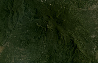 Bukit Daun has a complex summit with several peaks, and a possible landslide scarp on the upper western flank, seen in this August 2020 Planet Labs satellite image monthly mosaic (N is at the top; this image is approximately 22 km across). A crater on the eastern side of the summit area contains Telapak lake and to the south is a lava flow with levees and pressure ridges visible through the vegetation.
Satellite image courtesy of Planet Labs Inc., 2020 (https://www.planet.com/).
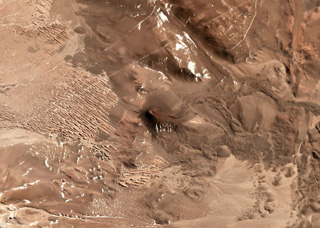 This unnamed scoria cone near the Chile/Argentina border has produced lava flows to the east, visible in this July 2019 Planet Labs satellite image Monthly Mosaic (N is at the top; this image is approximately 8.5 km across). The visible flows have clear lobate or broader flow boundaries, levees, and pressure ridges, while other lavas have been buried by sand deposits.
Satellite image courtesy of Planet Labs Inc., 2019 (https://www.planet.com/).


