Special Announcements
Special announcements or information of general interest not linked to any specific volcano.
Bulletin Reports - Index
Reports are organized chronologically and indexed below by Month/Year (Publication Volume:Number), and include a one-line summary. Click on the index link or scroll down to read the reports.
November 1994 (BGVN 19:11)  Cite this Report
Kamchatkan volcanoes activity reports halted by lack of funding
Following notice in early December that seismic stations at Shiveluch and Tolbachik had closed, on 22 December the following message was sent from the Alaska Volcano Observatory (AVO): "KVERT [Kamchatka Volcanic Eruptions Response Team] has informed AVO that, because of a long delay in promised funding from the Ministry of Transportation in Moscow, KVERT must suspend transmittal of information on volcanic activity in Kamchatka. The length of the suspension is unknown at this time. Expressions of concern and support... by interested parties would be appreciated."
An AVO Information Release on 9 January 1995 suggested that "Letters of concern might mention the Kamchatka Volcanic Eruptions Response Team under the leadership of Vladimir Kirianov, its value in monitoring and reporting of volcanic eruptions, the suspension of KVERT activities because of the delay in funding, the need for rapid transfer of funds, etc." Letters should be sent to the Russian Department of Air Transport official handling the KVERT funds [outdated contact information removed].
KVERT began regularly sending reports to AVO for further distribution in April 1993. Since then, KVERT has provided the overwhelming bulk of information for GVN reports about Kamchatkan volcanic activity, the first steady stream of information from this important region. For example, information provided by KVERT has described significant eruptions at Shiveluch (22 April 1993), Bezymianny (21 October 1993), and Kliuchevskoi (1-3 October 1994). Continuous activity at Shiveluch (gas-and-steam plumes, growth of extrusive lava dome) and Kliuchevskoi (minor ash explosions, gas-and-steam plumes, lava fountaining, lava flows) has also been consistently reported. Prompt notification of Kamchatkan eruptions is especially critical because of the large volume of international air traffic in the vicinity.
Information Contacts: Vladimir Yu. Kirianov, Institute of Volcanic Geology & Geochemistry (see Kliuchevskoi); Thomas P. Miller, Alaska Volcano Observatory (AVO), a cooperative program of a) U.S. Geological Survey, 4200 University Drive, Anchorage, AK 99508-4667, USA, b) Geophysical Institute, University of Alaska, PO Box 757320, Fairbanks, AK 99775-7320, USA, and c) Alaska Division of Geological & Geophysical Surveys, 794 University Ave., Suite 200, Fairbanks, AK 99709, USA.
May 1997 (BGVN 22:05) Cite this Report
Aviator's observation form
Tens of commercial jet aircraft, which are not designed to fly through particulate and corrosive gases, have suffered damage from inadvertently encountering ash clouds that had drifted tens to hundreds of kilometers from erupting volcanoes; in one case, a plane descended more than 6 km before the engines could be restarted (Casadevall, 1994). As a result of this vulnerability, there have been new and evolving strategies for alerting aviators as to the presence, location, and movement of eruption plumes. Conversely, pilots often see aspects of volcanism that merit preservation in the Bulletin. In order to solicit and register these observations, a form for pilots relates a series of key questions (plate 1, back page).
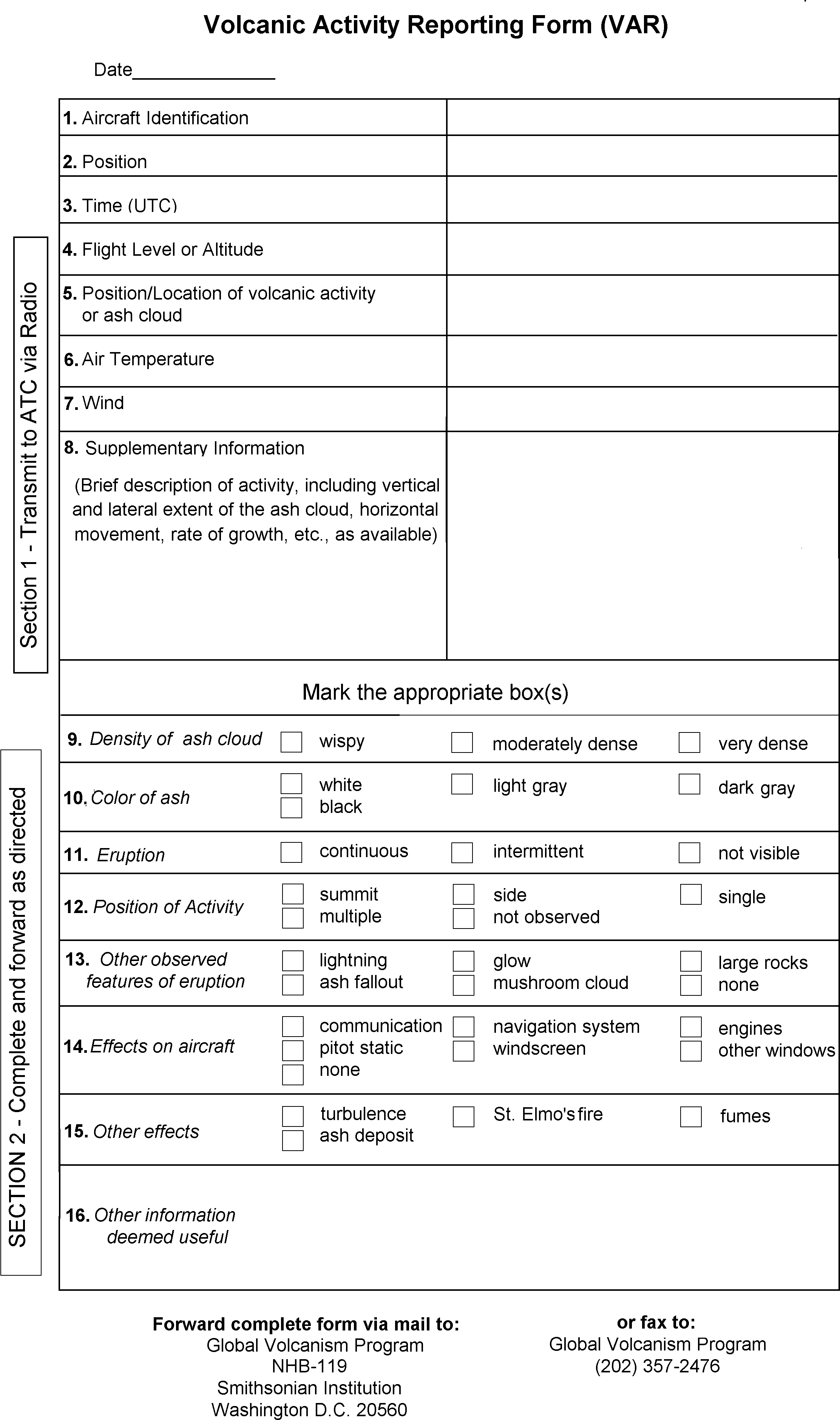 |
Plate 1. A form developed to help pilots record and submit their observations related to volcanism. Courtesy of Ed Miller, ALPA. |
The form, called the "Volcanic Activity Reporting Form," is now included in the US Aeronautical Information Manual (FAA, 1995), a reference used by all large US carriers. A similar form is in use by members of the International Civil Aviation Organization (ICAO).
The form is divided into two parts. The critical upper part (numbers 1-8) gets radioed to air traffic control immediately. Most of the form's lower part provides stated choices on topics such as ash density and color, continuousness of the eruption, as well as the effects on the aircraft and atmosphere (numbers 9-15). The last block (number 16) allows pilots to provide further written information.
The forms are ultimately to be sent (via mail or fax) to GVN for archiving. Expenses for postage or connections by fax can be reimbursed by the GVN.
In addition to the form itself, we wish to receive other aviation observations. These may include eyewitness accounts or photos made by passengers or crew, descriptions of damage, or ash collected by mechanics, as well as relevant weather details from meteorologists. These can (and already do) complement volcanological and atmospheric studies of eruptive activity. Ideally, such multiple perspectives can build a much more comprehensive picture of volcanic processes than can result from any one vantage point.
Every day thousands of people fly across potentially ash-contaminated airspace--to some degree, the people in these planes are just as vulnerable as villages perched on a volcano's flanks. Conventional planes still lack on- board instruments to warn pilots if hazardous atmospheric ash lies ahead. Such plumes are relatively rare, but to consistently avoid them requires interdisciplinary communication and cooperation between both aviators and scientists.
References. Casadevall, T.J. (ed.), 1994, Volcanic ash and aviation safety, Proceeding of the First International Symposium on Volcanic Ash and Aviation Safety (Seattle, Washington, July 1991): U.S. Geological Survey Bulletin 2047, 450 p.
Federal Aviation Administration, 1995, Volcanic Activity Reporting Form: US Aeronautical Information Manual (AIM), 1995 (June), Appendix 2 (1 May 1997), p. A2-1, Superintendent of Documents, US Government Printing Office, Washington, D.C.
Further Reference. Casadevall, T.J., and Thompson, T.B., 1995, Volcanoes and principal aeronautical features, Geophysical Investigation Map GP-1011: U.S. Geological Survey, prepared in cooperation with Jeppesen Sanderson, Inc.
Information Contacts: Captain Ed Miller (Retired), Air Line Pilots Association, 535 Herndon Parkway, P.O. Box 1169, Herndon, VA 20172-1169 USA; Tom Fox, Air Navigation Bureau, International Civil Aviation Organization (ICAO), 999 University St., Montreal H3C 5H7, Canada.
August 1997 (BGVN 22:08) Cite this Report
Seismic network installed for the first time in the Galapagos Islands
During 13 to 29 August 1997 the Geophysical Institute of the Escuela Politecnica Nacional (IG-EPN) in Quito, Ecuador, and the Charles Darwin Foundation installed the first seismographic network ever to be established in the Galápagos Islands, site of the well-documented Gal pagos mantle plume with its active volcanism. The network consists of three telemetered seismic stations located at Pta. Espinosa on the NE end of Fernandina Island (Station FERN; 0°16.0'S, 91°26.7'W, elev. 3 m), on the NE corner of Sierra Negra caldera (Volc n Chico) on Isabela Island (Station VCHI; 0°47.5'S, 91°04.0'W, elev. 1,490 m), and at Bartolome Island, at the E end of Santiago Island (station BART; 0°16.9'S, 90°33.1'W, elev. 100 m). The IRIS project is scheduled to install a wide-band station on Santa Cruz Island in the coming weeks. Once the IRIS device is operative, these four permanent stations will effectively constitute an array in the form of a parallelogram that will cover the western center of the archipelago.
The importance of the new network lies in its ability to monitor the active volcanoes of Fernandina, Volcán Chico, and Sullivan Bay, as well as more distant volcanic centers. In addition the new network will detect tectonic activity generated in this mantle-plume setting or associated with the NNW-SSE and ENE-WSW structural lineaments that apparently control the distribution of volcanoes and that were first recognized by Charles Darwin. The data will also provide better hypocenter locations for seismic events related to subduction of the Nazca and Cocos plates along the South American and Central American coasts.
The instrumentation includes vertical 1-Hz seismometers (Mark Products L-4C) set in massive lavas whose responses have attenuations of 12 to 18 dB. State-of-the-art electronics and radio telemetry as well as solar panels complete the systems. The seismic signals are continuously telemetered to the Charles Darwin Scientific Station located at Academy Bay on Santa Cruz Island. Data acquisition is carried out with the IASPEI software and the events sent via email to IG-EPN for processing.
After only a few days of operation, several low-magnitude A-type earthquakes were detected and tentatively located in the southern part of Isabela Island near Volcán Chico. Several medium-size events, well-located on the South American continent by regional and international seismographic networks, were recorded by the new Gal pagos net. Once the IRIS station is functioning, better identification of locations will be possible. It is hoped that in the future, if funding becomes available, two or three more seismic stations will be installed on other active volcanoes.
This project received financial aid and help from the USAID Mission in Quito, the Charles Darwin Foundation, the Escuela Politecnica Nacional, the Galápagos National Park Service, the Ecuadorian Air Force, the Civil Aviation Authority, Banco del Pacifico, the Ecuadorian Institute Electrification, TAME, ORSTOM, and the Charles Darwin Scientific Station.
Information Contacts: Minard L. Hall, Escuela Politecnica Nacional, Casilla 2759, Quito, Ecuador.
January 2003 (BGVN 28:01) Cite this Report
Global high-temperature thermal monitoring system (MODIS Thermal Alerts)
The MODIS Thermal Alerts website (http://modis.higp.hawaii.edu/) is the first truly global high-temperature thermal monitoring system for volcanic activity. This system is capable of detecting and documenting changes in active lava flows, lava domes, lava lakes, strongly incandescent vents, and hot pyroclastic flows. No alert is likely to be triggered by an ash cloud. MODIS cannot see through weather clouds and is also liable to miss events of less than several hours duration. Nevertheless, MODIS is capable of adding significant information to the record of global volcanic activity.
As described by Flynn and others (2001), Wright and others (2002), and Rothery and others (2003), the MODIS Thermal Alerts website provides a series of maps updated every 24 hours to show 'thermal alerts' based on night-time (approximately 2230 local time) infrared data from the Moderate Resolution Imaging Spectroradiometer (MODIS) instrument that is carried by NASA's Terra and Aqua satellites. Thermal alerts are based on an 'alert ratio' (3.9 µm radiance - 12 µm radiance) / (3.9 µm radiance + 12 µm radiance) and an alert is triggered whenever this ratio has a value more positive than -0.8. This threshold value was chosen empirically by inspection of images containing known volcanic sites at high temperature, and is the most negative value that avoids numerous false alarms. There are also some day-time alerts (at approximately 1030 local time) based on the same algorithm. These incorporate a correction for estimated solar reflection and a more stringent threshold, whereby the alert ratio must be more positive than -0.6 to trigger an alert.
In order to bring this valuable tool to the attention of a wider community, Dave Rothery and Diego Coppola have provided an analysis of volcanic activity detected by MODIS in Melanesia from January 2001 to December 2002, which they relate as fully as possible to conventional observations in the Bulletin of the Global Volcanism Network. In the cases of Manam, Rabaul, Ulawun, and Pago there is a high degree of correspondence between MODIS alerts and independently derived observations. In the cases of Bagana, Tinakula, and Ambrym the MODIS alerts represent the only hitherto reported evidence of activity during 2001-2002. Lopevi and Yasur are intermediate cases, where MODIS adds significantly to what has previously been reported. All the 'new' activity is not necessarily unknown to local volcanologists (though this may be so in some cases), and in fact additional information from local sources would help to refine the MODIS interpretation. However, the MODIS Thermal Alerts provide a useful source of near real-time information that is openly available for the benefit of the global volcanism community.
Graphs of the 'alert ratio' and number of alerted pixels indicate the magnitude of every anomaly detected during the period. In some cases these are accompanied by maps indicating the center coordinates of the alerted pixels. The original pixels are 1 x 1 km squares, which means that the true site of a spatially small anomaly that has triggered an alert can be anywhere within a 1-km box surrounding the center point. The geolocational accuracy of MODIS pixel coordinates is generally reckoned to be better than 1 km, but may become worse for high volcanoes, especially when seen close to the edge of an imaging swath (when the satellite can be more than 45 degrees away from the zenith). Furthermore, for some of the more remote volcanoes MODIS scientists believe there may remain significant map-location errors.
References. Flynn, L.P., Wright R., Garbeil, H., Harris, A.J.L., and Pilger, E., 2001, A global thermal alert system using MODIS: initial results from 2000-2001: Advances in Environmental Monitoring and Modelling, no. 3, Monitoring volcanic hotspots using thermal remote sensing, edited by Harris, A.J.L., Wooster, M.J., and Rothery, D. A. (http://www.kcl.ac.uk/kis/schools/hums/geog/advemm/vol1no3.html).
Wright, R., Flynn, L., Garbeil, H., Harris, A., and Pilger, E., 2002, Automated volcanic eruption detection using MODIS: Remote Sensing of Environment, v. 82, p. 135-155.
Rothery, D.A., Thorne, M.T., and Flynn, L., 2003, MODIS thermal alerts in Britain and the North Sea during the first half of 2001: International Journal of Remote Sensing, v. 24, p. 817-826.