Report on Cotopaxi (Ecuador) — August 2023

Bulletin of the Global Volcanism Network, vol. 48, no. 8 (August 2023)
Managing Editor: Kadie Bennis.
Cotopaxi (Ecuador) Ash emissions, ashfall, and occasional lahars during February-July 2023
Please cite this report as:
Global Volcanism Program, 2023. Report on Cotopaxi (Ecuador) (Bennis, K.L., ed.). Bulletin of the Global Volcanism Network, 48:8. Smithsonian Institution.
Cotopaxi
Ecuador
0.677°S, 78.436°W; summit elev. 5911 m
All times are local (unless otherwise noted)
Cotopaxi is a steep-sided cone capped by nested summit craters, located in Ecuador. The largest cone is about 550 x 800 m. Explosive eruptions have been accompanied by pyroclastic flows and lahars, the latter of which frequently affect adjacent valleys. The most recent eruption began in October 2022 and consisted of ash plumes and ashfall (BGVN 48:02). This report covers activity during February through July 2023, which was characterized by similar activity. Information comes from Ecuador's Instituto Geofísico, Escuela Politécnica Nacional (IG-EPN) and the Washington Volcanic Ash Advisory Center (VAAC).
Activity during February consisted of constant gas-and-steam emissions that rose 200-2,500 m above the crater and drifted in multiple directions, and seismicity that was characterized by daily tremor events associated with emissions (TR) and long-period events (LP), and less frequent volcano-tectonic events (VT) and very long-period events (VLP). The Washington VAAC reported during 31 January to 4 February that gas-and-ash emissions rose 1.1-2.5 km above the summit and drifted in multiple directions. Beginning at 0100 on 2 February IG reported an increase in seismic signals associated with ash emissions that rose 1.3 km above the summit and drifted NW (figure 25). There were reports of ashfall in the N part of the Cotopaxi National Park in Quito and Mejía, particularly in Amaguaña (35 km NNW), La Armenia, Quitumbe (41 km NNW), Conocoto (41 km N), Guamaní (42 km NNW), La Ecuatoriana (44 km NNW), Turubamba (43 km NNW), Chillogallo (47 km NNW), La Magdalena (48 km NNW), Machachi, Tambillo (32 km NNW), Alóag (28 km NW), Cutuglahua (35 km NNW), Uyumbicho (30 km NNW), Aloasí (24 km NW), and El Chaupi (24 km WNW) during 2-4 February. On the morning of 3 February continuous gas-and-ash emissions were reported, resulting in slight ashfall in Tambillo, Chillogallo, and La Armenia 2 and later that same day in Guamaní, Turubamba, Chillogallo, La Ecuatoriana, Quitumbe, Tambillo, Machachi, Aloasí, Aloag (28 km NW), and Conocoto.
 |
Figure 25. Webcam image of a gray ash plume rising above Cotopaxi on 2 February 2023. Courtesy of IG-EPN (IG Al Instante Informativo VOLCÁN COTOPAXI No 2023-023). |
During 9-10, 12-19, and 26-27 February the Washington VAAC reported that gas-and-ash emissions rose 200-1,400 m above the crater and drifted W, NW, S, and SE. At 1800 on 9 February an ash plume rose 2 km above the summit and drifted W according to IG-EPN. Slight ashfall was reported in Tambillo. During the night and early morning of 11-12 February gas-and-ash emissions rose less than 500 m above the crater and drifted SW; there were some reports of light ashfall in El Chasqui (17 km W), Mulaló (19 km SW) and San Juan de Pastocalle (20 km WSW). Around 0810 the BREF seismic station recorded an increase in tremor energy, which is associated with ash emissions. During 13-14 February several gas-and-ash emissions rose as high as 1 km and drifted W and SW, resulting in minor ashfall in Mulaló, San Agustín (11 km W), Ticatilín (15 km WSW), San Ramón (17 km SW), Control Caspi (20 km WSW), and Pastocalle (22 km W). Starting around 0630 on 15 February ashfall was observed in Mulaló 2, San Ramón (17 km SW), Ticatilín (15 km SW), and San Agustín del Callo (18 km WSW). According to the Network of Volcanic Observers (ROVE), ashfall was reported in Latacunga canton (18 km WSW) during the night of 15 February. On 16 February at 0600 ash emissions rose 1 km above the summit and drifted E, based on surveillance cameras (figure 26). Starting at 0230 on 18 February IG reported an increase in seismic signals that were associated with ash emissions; by 0650 satellite images showed an ash plume that rose 800 m above the summit and drifted SE. Around 0030 on 19 February an ash plume rose 1.1 km above the crater and drifted S. During the morning of 27 February gas-and-ash emissions rose 1 km above the summit and drifted SE; light ashfall was reported in Pichincha en Rumiñahui (61 km N), Rumipamba Vallecito (55 km N), Conocoto, Pedregal (60 km N), Guamaní, Quitumbe, La Ecuatoriana, Chillogallo, Urubamba (Santo Tomas, 40 km NNW), La Magdalena (Barrio Nuevo, Villaflora), and San Bartolo. On 28 February at 1430 surveillance cameras showed an ash plume that rose 500 m above the summit and drifted SW.
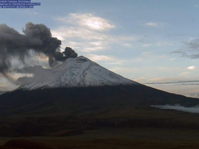 |
Figure 26. Webcam image of an ash emission rising 1 km above the summit of Cotopaxi and drifting E on 16 February 2023. Photo has been color corrected. Courtesy of IG-EPN (IG Al Instante Informativo VOLCÁN COTOPAXI No 2023-031). |
Ash emissions continued during March, rising 1-1.5 km above the summit, and drifting in different directions. Seismicity consisted of daily LP and near-daily TR events and less frequent VT and VLP events. Intermittent gas-and-steam emissions rose 100-1,500 m and drifted in different directions. According to the Washington VAAC ash emissions rose 500-2,000 m above the summit and drifted in multiple directions during 28 February to 3 March, 4-5, 18-19, and 24-29 March. Light ashfall was reported in Mulaló during 28 February to 1 March and 5-6 March. On 19 March at 0900 surveillance cameras captured an ash emission that rose 1 km above the summit and drifted E (figure 27). A thin ash cloud was observed in GOES-16 satellite images rising 500 m above the summit and drifted SW on 25 March. Around 0310 on 28 March a GOES-16 satellite image showed an ash cloud rising 1 km above the summit and drifted N. As a result, light ashfall was observed in Machachi and on the N flank of the volcano and in El Chasqui, Latacunga, and the S flank of the volcano during 28-29 March.
 |
Figure 27. Webcam image of an ash emission rising 1 km above the summit of Cotopaxi and drifting E on 19 March 2023. Photo has been color corrected. Courtesy of IG-EPN (IG Al Instante Informativo VOLCÁN COTOPAXI No 2023-036). |
Gas-and-steam emissions continued during April, rising 200-1,500 m above the crater, and drifting in different directions. Seismicity consisted of daily LP and near-daily TR events and less frequent VT events. Gas-and-ash emissions rose 200-1,500 m above the crater and drifted W, SW, E, and SE. During 4-6 and 9-10 April the Washington VAAC reported that ash emissions rose 200-1,100 m above the crater and drifted SW, SE, and E. A lahar occurred on the upper W flank on 5 April due to moderate rainfall. Light ashfall was reported in Mulaló and San Agustín during 5-6 April. On 8 April at 0900 a surveillance camera showed an ash plume that rose 500 m above the summit and drifted E and on 10 April at 0500 an ash plume rose 1.1 km above the summit and drifted W. During the night of 11 April, a small, secondary lahar was descended the Agualongo drainage. Another lahar was recorded during 12-13 April, though it was not observed due to cloud cover. On 15 April a small lahar was observed on the NW flank. The BNAS seismic station recorded an increase in seismic signal at 1600 on 22 April that corresponded to a small lahar, which descended the Cutzulao/Agualongo drainages. During 23-24 April the Washington VAAC reported ash emissions that rose as high as 2,028 m above the summit and drifted NE. According to IG-EPN surveillance camera showed an ash plume rising 3 km above the summit and drifted NE at 0953 (figure 28). During 24-25 and 28-30 April ash emissions rose 200-2,000 m above the crater and drifted NE and W. According to ROVE, ashfall was reported in the S area of the national park around 1805.
 |
Figure 28. Webcam image of an ash emission rising 3 km above the summit of Cotopaxi and drifting NE on 24 April 2023. Photo has been color corrected. Courtesy of IG-EPN (INFORME DIARIO DEL VOLCAN COTOPAXI No. 2023-114). |
Similar activity continued during May. Seismicity was characterized by daily LP and near-daily TR events and occasional VT events. Gas-and-steam emissions rose 200-1,500 m above the summit and drifted in different directions. Gas-and-ash emissions rose 200-1,400 m above the crater and drifted W, SW, NW, and SE. On 1 May at 0130 and on 8 May the BNAS seismic station recorded high-frequency seismic signals that corresponded to small lahars that remained within the Cotopaxi National Park. An ash plume was observed in a GOES-16 satellite image around 1100 that rose 1.5 km above the summit and drifted WNW, reaching Manabí on 4 May. Light ashfall was reported in Mulaló during 6-7 May. At 0600 on 7 May an ash plume rose 500-1,100 m above the summit and drifted W and SW. Ashfall was reported in Mulaló. The Washington VAAC reported that ash emissions rose 800 m above the summit and drifted NW during 7-8 May. During 9-10 May a moderate ash plume rose 2-3 km above the summit and drifted SW, N, and NE. Ashfall was reported in San Joaquín (SW) and San Agustín de Callo (SW). Another ash plume rose 2 km above the summit and drifted SE at 0749 on 12 May (figure 29). Intermittent ash plumes rose 1-3 km above the summit starting at 0510 on 18 May and drifted NE. As a result, light ashfall was reported in Machachi. Continuous ash emissions were recorded during the morning of 26 May, rising 1.5-2 km above the crater and drifting W and NW. Ash emissions rose as high as 1.1 km above the summit and drifted W and SW during 29-30 May according to the Washington VAAC. At 0600 surveillance cameras and satellite images showed an ash plume rising 1.1 km above the crater and drifted as far as 40 km W. Ashfall was reported in Pastocalle. During 30-31 May an ash emission rose 500 m above the summit and drifted W, based on a Washington VAAC report.
 |
Figure 29. Webcam image showing an ash plume rising as high as 2 km above the summit of Cotopaxi on 12 May 2023. Courtesy of IG-EPN (IG Al Instante Informativo VOLCÁN COTOPAXI No 2023-048). |
During June, gas-and-steam emissions rose 100-500 m above the summit and seismicity continued with daily LP and near-daily TR events and less frequent VT events. Gas-and-ash emissions rose 100-1,000 m above the summit and drifted in several directions. Light ashfall was reported in San Agustín de Callo and San Ramón during 1-2 June. Ash emissions rose 1 km above the summit and drifted SW during 1746-2000 on 3 June. According to the Washington VAAC, ash emissions rose 800 m above the summit and drifted SW during 4-5 June. A seismic signal was recorded on the NW flank on 8 June that IG reported was possibly associated with a small lahar. Around 0900 on 21 June an ash cloud rose less than 500 m above the summit and drifted over the W and SW flanks due to strong winds; light ashfall was reported in the Cotopaxi National Park. Starting around 1400 on 27 June through 28 June a high-frequency tremor signal was recorded at the BREF and BNAS seismic stations associated with small lahar signals moving through the Agualongo Creek; the flows were limited to the Cotopaxi National Park. Around 1300 on 29 June two seismic signals relating to small lahars were recorded on the W flank of the volcano moving down the Agualongo Creek.
Activity during July was relatively low and was mainly characterized by gas-and-steam emissions rising 100-1,800 m above the summit and seismicity consisting of daily LP and near-daily TR events and less frequent VT events. During the afternoon of 1 July, a high-frequency seismic signal was recorded on the NW flank relating to a small lahar. Gas-and-ash emissions rose 100-1,100 m above the summit and drifted SW and W. The Washington VAAC reported an ash emission that rose 500 m above the summit and drifted SW during 2-3 July. Light ashfall was reported in Mulaló, including Rosal, Ticatilín, San Agustín del Callo, San Ramón, and Rumipamba de Villacis. On 5 July around 0700 an ash plume rose 600 m above the summit and drifted SW, based on a GOES-16 satellite images. According to IG-EPN cameras and ROVE reports, remobilized ash was observed on the W flank resulting from strong winds during 18-19 July.
Geological Summary. The symmetrical, glacier-covered, Cotopaxi stratovolcano is Ecuador's most well-known volcano and one of its most active. The steep-sided cone is capped by nested summit craters, the largest of which is about 550 x 800 m in diameter. Deep valleys scoured by lahars radiate from the summit of the andesitic volcano, and large andesitic lava flows extend to its base. The modern edifice has been constructed since a major collapse sometime prior to about 5,000 years ago. Pyroclastic flows (often confused in historical accounts with lava flows) have accompanied many explosive eruptions, and lahars have frequently devastated adjacent valleys. Strong eruptions took place in 1744, 1768, and 1877. Pyroclastic flows descended all sides of the volcano in 1877, and lahars traveled more than 100 km into the Pacific Ocean and western Amazon basin. Smaller eruptions have been frequent since that time.
Information Contacts: Instituto Geofísico, Escuela Politécnica Nacional (IG-EPN), Casilla 17-01-2759, Quito, Ecuador (URL: http://www.igepn.edu.ec/); Washington Volcanic Ash Advisory Center (VAAC), Satellite Analysis Branch (SAB), NOAA/NESDIS OSPO, NOAA Science Center Room 401, 5200 Auth Rd, Camp Springs, MD 20746, USA (URL: www.ospo.noaa.gov/Products/atmosphere/vaac, archive at: http://www.ssd.noaa.gov/VAAC/archive.html).