Report on Redoubt (United States) — February 1990
Bulletin of the Global Volcanism Network, vol. 15, no. 2 (February 1990)
Managing Editor: Lindsay McClelland.
Redoubt (United States) Repeated strong explosions separated by growth of small lava domes; details of 15 February pyroclastic flow, surge, and lahar deposits
Please cite this report as:
Global Volcanism Program, 1990. Report on Redoubt (United States) (McClelland, L., ed.). Bulletin of the Global Volcanism Network, 15:2. Smithsonian Institution. https://doi.org/10.5479/si.GVP.BGVN199002-313030
Redoubt
United States
60.485°N, 152.742°W; summit elev. 3108 m
All times are local (unless otherwise noted)
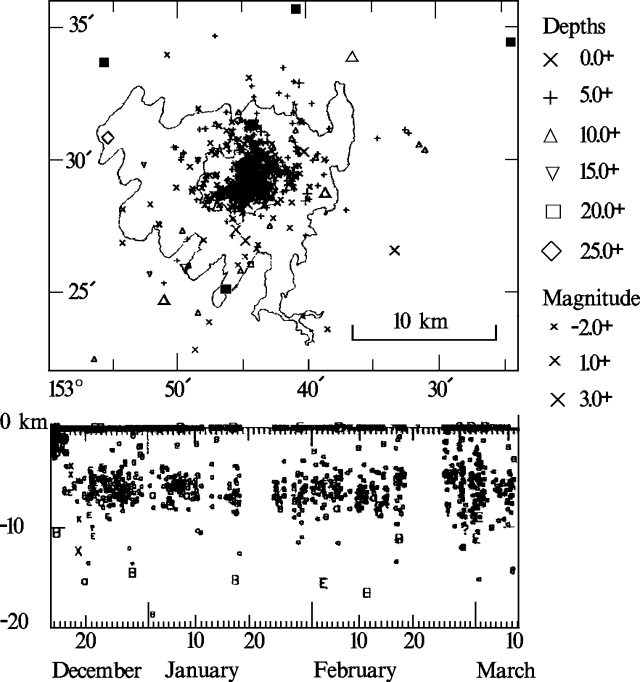
Strong explosions separated by periods of lava dome growth continued into March (table 1). Frequent seismicity, centered on Redoubt from the surface to about 10 km depth, has continued since mid-December (figure 6). Information about the 15 and 21 February explosive episodes supplements the initial reports in 15:01.
Table 1. Strong explosive episodes and periods of lava extrusion during Redoubt's 1989-90 eruption, modified extensively from the original table with data from Brantley (1990). See Alaska Volcano Observatory, 1990, for a more detailed tabular summary of activity through January.
| Date | Time | Duration (minutes) | Activity |
| 14 Dec 1989 | 1013 | 47 | First major explosion; plume to 10+ km; debris flows and floods. |
| 15 Dec 1989 | 0140 | 60 | -- |
| 15 Dec 1989 | 0340 | 60 | -- |
| 15 Dec 1989 | 1015 | 45 | Plume to 12+ km; KLM jet loses power but lands safely; major lahar. |
| 22 Dec-02 Jan 1990 | -- | -- | Lava dome grows (to roughly 25 x 106 m3) |
| 02 Jan 1990 | 1748 | 40 | Plumes to 12 km; major lahars. |
| 02 Jan 1990 | 1927 | 75 | -- |
| 08 Jan 1990 | 1009 | 30 | Plume to 12+ km; debris flow smaller than on 2 January. |
| 15 Jan-15 Feb 1990 | -- | -- | Extrusion of small dome, perhaps 1/4-1/3 the size of the late December-early January dome. |
| 15 Feb 1990 | 0403 | 18 | Plume to 10+ km; pyroclastic surge and flood. |
| 15 Feb-20 Feb 1990 | -- | -- | Lava extrusion and small pyroclastic flows. |
| 21 Feb 1990 | 0032 | 12 | Heavy ashfalls to NE but little flooding. |
| 24 Feb 1990 | 0505 | 15-20 | Plume to 9 km; substantial flooding. |
| 24 Feb-28 Feb 1990 | -- | -- | Lava extrusion. |
| 28 Feb 1990 | 0846 | 10 | Moderate explosive activity; plume below 6-8 km altitude. |
| 28 Feb 1990 | 0947 | -- | Plume to 11 km; ashfall to 450 km NE; pyroclastic flows but little flooding. |
| 04 Mar 1990 | 2039 | -- | Plume to 12-12.5 km; increased water flow. |
| 09 Mar 1990 | 0951 | -- | Ash-poor plume to 10.5 km; moderate flooding. |
| 10 Mar-13 Mar 1990 | -- | -- | Extrusion of small lava dome. |
| 14 Mar 1990 | 0947 | -- | Ash-poor plume to 12 km; moderate flooding. |
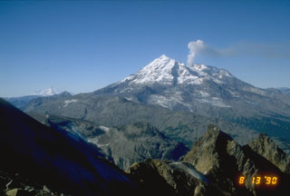
Explosive episode, 15 February; deposits and morphologic changes. Fieldwork after the episode revealed changes in the vent area, and pyroclastic flow, surge, and lahar deposits. The explosion had removed about 75% of the dome, leaving only a steep remnant of its W portion. The concentrically fissured icewall S of the vent appeared unchanged and remained steep. Steam from vigorous fumaroles obscured the vent area and the north gorge, a steep gully that had been cut into the upper Drift Glacier. Heavy ashfall had occurred over a broad area of the NNW to W flanks within 5-6 km from the vent, and airfall tephra was also evident to 6-8 km S and 20 km E to ENE of the vent. On the NNW flank, snow avalanches or slush flows moved across snow-covered glaciers and into gullies W of those affected by earlier explosions. A sheet flood of slush flows traveled NE and E from the summit, entering the Drift River from a small valley (E of Drift Glacier) also unaffected by previous explosions. A pyroclastic surge had spread N across the Drift Glacier to the crest of a steep ridge 750-900 m above the glacier's toe. The deposit near the ridge crest, 1-8 mm thick, was dominated by sand-sized andesite fragments with occasional pebble-sized grains. In a creek valley NE of the ridge, the deposit was coarser (very angular, coarse sand-sized andesite grains) and thicker (4-8 mm). The deposit also included willow branches to 8 cm in diameter and 1.5 m long, slightly scorched and thrust as much as 1 m into the snow. The surge was diverted eastward by the ridge, depositing dark material against another ridge 4-5 km to the NE, in a zone from about 450 to 850 m altitude. The base of this zone was about 300 m above the valley floor. The surge destabilized snow on steep sides of S- and SW-facing valleys, triggering snow avalanches (some ash-rich) and slush flows.
Drift Glacier was mantled by a deposit of poorly sorted, massive, pebbly, medium sand-sized, pyroclastic flow material. The deposit ranged from a few centimeters thick on slopes to considerably more on flat areas, and appeared to be concentrated on the E half of the glacier. Portions of the deposit that were more than 20 cm thick were loose, easily fluidized, and hot (230°C at 20 cm depth measured at one site 9 hours after the eruption). Flooding had wet the top 10-15 cm of the deposit in gullies. The glacier itself was much more deeply gullied than it had been after the 8 January explosion, with many large ice blocks partially detached from the glacier surface.
The pyroclastic flow(s) and surge fed a mixed flood of water and pyroclastic debris that caused considerable erosion of the glacier and the banks of the Drift River (W of the glacier's Piedmont Lobe). Most of the debris was sand-sized, but included clasts (some juvenile) up to 1 m in diameter, plus clear ice from Drift Glacier and large amounts of snow from the glacier and valley. Hot andesitic dome rocks were found as much as 37 km from the dome (30 km from the glacier). The flow was apparently very water-rich for its entire length, which extended 33-35 km from the glacier to the oil facility at the mouth of the Drift River. Heights of overtopped banks suggested that the flow was 5 m or more deep in the gully on the E side of the glacier and was still 1-2 m deep in the lower valley. A zone of snow blocks 1-8 m wide marked flow margins.
Flow characteristics were detailed from field evidence. The W portion of the flow moved as much as 15-20 m up a valley moraine, and energy calculations suggested a minimum velocity of 60-70 km/hour. About halfway down the valley, flow speed had apparently slowed to less than 30 km/hour, while evidence of splashing against the valley wall indicated considerable turbulence. Although the flow filled most portions of the valley from wall to wall, islands were left in wider sections, suggesting a maximum discharge less than that on 2 January. Below the canyon mouth, some of the peak flow followed the old Drift River channel, but most went into Rust Slough, a relatively low-capacity stream. Muddy water from Rust Slough entered the oil facility roughly 4 hours after the onset of the eruptive episode, flooding a larger area than on 2 January, but caused no major damage. Some water seeped through (but did not flow over) the southernmost tank's containment dike, and did no apparent damage.
Small pyroclastic flows and dome growth, 15-20 February. A pyroclastic flow moved about halfway down the Drift Glacier's north gorge on 15 February between about 1450 and 1505. Gas jetting had been audible about 30 minutes earlier, and an abrupt 40% increase in stream discharge preceded the pyroclastic flow by about 15 minutes. An overflight on 18 February revealed that a small new lava dome was growing in the previously active vent. Geologists observed another pyroclastic flow, triggered by dome collapse, that moved down the gorge on 20 February at 1338. A dark ash plume rose from the flow to about 3.5-4.5 km altitude, depositing a small amount of ash to the ENE. A similar but larger episode was seen from the Drift River oil facility at about 0600, accompanied by a plume and lightning. Steaming pyroclastic flow deposits in the gorge extended to about 700 m altitude, and fresh ash ENE of the vent, primarily from the early morning episode, lay on snow that had fallen 16-17 February.
Explosive episode, 21 February. An explosion that produced a large steam and ash plume accompanied by thunder and lightning began at 0032 and lasted for about 12 minutes. Ash deposits appeared thick NE of the volcano. Ashfall was reported at Kenai (80 km E), Hope (175 km ENE), and Girdwood (200 km ENE), and significant ashfall at the Drift River oil facility prevented evacuation of its crew. Both the Drift River and Rust Slough were bank-full before the activity began, but much less additional stream flow was generated by this explosive episode than on 15 February and only minor flooding resulted, without reported damage or injuries. The small dome that had been growing in the crater was partially destroyed by the explosion. Some pyroclastic flow deposits were visible on the glacier near the gorge.
Explosive episode, 24 February. Seismic stations near Redoubt began to record a strong signal associated with explosive activity at 0505. Amplitude increased sharply after 45 seconds, saturating instruments 8 km S and 11 km NW of the volcano for 3 1/2 minutes, then gradually decreased for 10-12 minutes. Seismicity had returned to background after 15-20 minutes. A steam and ash column rose to about 9 km altitude, accompanied by thunder and lightning. Heavy weather clouds prevented observations by satellites, but ashfall was reported along a narrow zone extending NE from the volcano. At the Beluga power plant (130 km NE of Redoubt), the main power source for Anchorage, light ashfall began at about 0630 and heavy ashfall 30 minutes later. All but one of its gas turbines were shut down to prevent damage. Ashfall stopped at Beluga by 0935, and was reported farther NE of Redoubt at Alexander (150 km from Redoubt, before 0935), Willow (200 km NE, 0800-0945), Kashwitna (210 km NE, 0930), and Montana (230 km NE, well before midafternoon). Water in Rust Slough, W of the Drift River oil facility, abruptly rose 2/3-1 m at 0915, then stabilized and began to recede after about 15 minutes. A second crest, at 1015, flooded the S half of the oil facility's runway. Helicopter observations suggested that about 30% of the Drift River/Rust Slough channel was occupied during peak flow. Aerial observations revealed that another small lava dome had begun to grow in the active vent after the 24 February explosion.
Explosive episode, 28 February. Seismic data indicated that explosive activity began at 0846, continued at a relatively low level for about 10 minutes, paused, then resumed more vigorously at 0947. During the initial pulse, no ash rose above the tops of weather clouds at 6-8 km altitude. Ash was reported at 11 km altitude within 9 minutes of the onset of the much stronger second pulse. Satellite data showed a cloud about 25 km across extending ENE from Redoubt at 1000, as ashfall was beginning on oil platforms in the Cook Inlet. Light ashfall had begun in the Anchorage area, roughly 170 km ENE of Redoubt, by 1130, and was reported at Talkeetna (about 250 km NE), Fort Richardson (NE of Anchorage), the Prince William Sound area (roughly 300 km E), and the Copper River basin (roughly 450 km NE). By 1400, infrared imagery showed a cloud about 120 km long and 100 km wide moving rapidly ENE, nearly 600 km from the volcano. A seismometer near the Drift River recorded 2 apparent flow events, the first associated with the initial pulse, the second, much larger, with the stronger second pulse. Significant flooding was anticipated for the lower Drift River, but instead, its flow declined somewhat. During field work several days later, deposits from numerous pyroclastic flows were found on the Drift Glacier, some of which may have temporarily blocked the main N flank drainage channel on the glacier. Such blockage, if any, had ended by 4 March.
Explosive episode, 4 March. A large explosive eruption occurred at 2039. An airplane pilot reported that the eruption cloud had reached about 12 km altitude 30 minutes after the onset of the activity. The cloud moved N, and ashfall was reported about 30 km NNE of the volcano. By 2330, infrared imagery from the GOES satellite showed a cloud about 55 km (W-E) x 50 km (N-S) 325 km N of the volcano. Comparison of the satellite-derived cloud temperature with radiosonde temperature profiles from Anchorage 8 1/2 hours earlier suggested an altitude of about 12.5 km for the top of the dense portion of the cloud. Increased water flow, but no flooding, was reported from the Drift River oil facility. [See also 15:3].
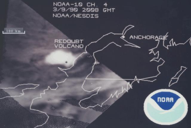
Explosive episode, 9 March. An explosion at 0951 ejected an ash-poor plume that reached about 10.5 km altitude, accompanied by lightning. The explosion was slightly larger than those of 21, 24, and 28 February, and 4 March, but significantly smaller than the 15 December, 2 January, and 15 February episodes. At 1108, a satellite image showed a plume about 90 km across (E-W), extending N and W from the volcano (figure 7). Ash fell to the W and NW, as much as 55 km from the volcano (in the Lake Clark Pass area). Flooding occurred in the Drift River, and water flowed into small streams just to the S (Rust Slough and Cannery Creek), but no water penetrated dikes protecting the Drift River oil facility. The activity was preceded by a magnitude 5.5 earthquake centered 82 km below Redoubt. Shallow seismicity remained elevated for 3-4 hours after the explosion, then declined, but remained above background level. By the next day, a small dome was again being extruded from the summit vent, and seismic data indicated continued dome growth through 13 March. [See also 15:3].
Explosive episode, 14 March. Explosive activity began at 0947, ejecting a plume to 12 km altitude that was also accompanied by lightning. There was little or no ash in the upper portion of the plume. Seismic data suggested that the explosion was slightly more vigorous than on 9 March, but the plumes appeared similar. Most of the ashfall occurred E and NE of the volcano on the W side of Cook Inlet. Traces of ash were reported on the Kenai Peninsula and in the Anchorage area. Satellite data at 1030 showed a plume moving ENE. The satellite-derived temperature of the dense portion of the plume was -40°C, corresponding to an altitude of about 7 km. Moderate flooding occurred in the lower Drift River, and some water was again diverted into Rust Slough and Cannery Creek. Water did not enter the oil facility, where 90,000 gallons of oil had leaked through a defective or open valve on 10 March. The oil had been confined by a containment dike, and most had been cleaned up by the time of the 14 March activity. [See also 15:3].
Geological Summary. Redoubt is a glacier-covered stratovolcano with a breached summit crater in Lake Clark National Park about 170 km SW of Anchorage. Next to Mount Spurr, Redoubt has been the most active Holocene volcano in the upper Cook Inlet. The volcano was constructed beginning about 890,000 years ago over Mesozoic granitic rocks of the Alaska-Aleutian Range batholith. Collapse of the summit 13,000-10,500 years ago produced a major debris avalanche that reached Cook Inlet. Holocene activity has included the emplacement of a large debris avalanche and clay-rich lahars that dammed Lake Crescent on the south side and reached Cook Inlet about 3,500 years ago. Eruptions during the past few centuries have affected only the Drift River drainage on the north. Historical eruptions have originated from a vent at the north end of the 1.8-km-wide breached summit crater. The 1989-90 eruption had severe economic impact on the Cook Inlet region and affected air traffic far beyond the volcano.
Information Contacts: AVO Staff; SAB; UPI; AP; Reuters.


