Report on Colima (Mexico) — February 1990

Bulletin of the Global Volcanism Network, vol. 15, no. 2 (February 1990)
Managing Editor: Lindsay McClelland.
Colima (Mexico) Summit dome fumaroles remain hot, but those in upper flank fractures cool considerably
Please cite this report as:
Global Volcanism Program, 1990. Report on Colima (Mexico) (McClelland, L., ed.). Bulletin of the Global Volcanism Network, 15:2. Smithsonian Institution. https://doi.org/10.5479/si.GVP.BGVN199002-341040
Colima
Mexico
19.514°N, 103.62°W; summit elev. 3850 m
All times are local (unless otherwise noted)
"Geologists from Florida International University and the Universidad de Colima visited the central crater and dome complex on 3 and 7 March. Fumarole temperatures have decreased dramatically in fractures just below the summit dome. The maximum temperature recorded in upper NE flank fractures was 100°C, down from 895°C in December 1985. The plume was much smaller during the 1990 visit, and no new tephra was found in the summit area.
"Temperatures of three fumaroles on the summit lava dome were measured at 3-minute intervals for about 4 days (figure 7). Surface temperatures were monitored simultaneously. The three measured fumaroles, on the SW side of the dome, had the highest temperatures found.
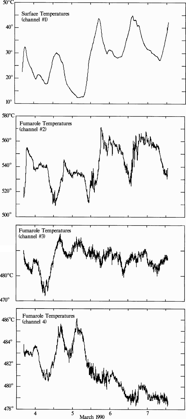 |
Figure 7. Temperature profiles at three fumaroles (channels 2-4) and surface temperatures (channel 1) on the SW side of Colima's summit lava dome, 3-7 March 1990. Note the differing temperature scales. Courtesy of C. Connor. |
"Two fumaroles (channels 3 and 4 on figure 7), located in the same fracture ~ 10 m apart, had a similar temperature range and showed a high degree of cross-correlation. The fracture trended about N70°E and extended for at least 200 m across the summit dome. Its maximum width was ~ 15 cm. The third fumarole (channel 2) was in a different fracture, oriented about E-W and about 6 m from the channel 4 fumarole. Channel 2 data were quite rhythmic, showing minimum temperatures each day about 1200, followed by maximums around 1830. This fumarole had a maximum temperature of 571°C on 5 March at 1827. One of 11 local earthquakes recorded (by CICBAS) during the sampling period occurred the same day at 1826. Channels 1 (surface temperature) and 2 retained relatively high temperatures after this event for the remainder of the sampling period, while channels 3 and 4 remained comparatively steady."
Geological Summary. The Colima complex is the most prominent volcanic center of the western Mexican Volcanic Belt. It consists of two southward-younging volcanoes, Nevado de Colima (the high point of the complex) on the north and the historically active Volcán de Colima at the south. A group of late-Pleistocene cinder cones is located on the floor of the Colima graben west and east of the complex. Volcán de Colima (also known as Volcán Fuego) is a youthful stratovolcano constructed within a 5-km-wide scarp, breached to the south, that has been the source of large debris avalanches. Major slope failures have occurred repeatedly from both the Nevado and Colima cones, producing thick debris-avalanche deposits on three sides of the complex. Frequent recorded eruptions date back to the 16th century. Occasional major explosive eruptions have destroyed the summit (most recently in 1913) and left a deep, steep-sided crater that was slowly refilled and then overtopped by lava dome growth.
Information Contacts: C.B. Connor, Florida International University, Miami; J. Piza Espinosa, Universidad de Colima.