Report on Rumble III (New Zealand) — March 1990
Bulletin of the Global Volcanism Network, vol. 15, no. 3 (March 1990)
Managing Editor: Lindsay McClelland.
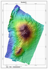
Rumble III (New Zealand) Submarine summit bathymetry; bubble plumes in water column
Please cite this report as:
Global Volcanism Program, 1990. Report on Rumble III (New Zealand) (McClelland, L., ed.). Bulletin of the Global Volcanism Network, 15:3. Smithsonian Institution. https://doi.org/10.5479/si.GVP.BGVN199003-241130
Rumble III
New Zealand
35.745°S, 178.478°E; summit elev. -220 m
All times are local (unless otherwise noted)
The following observations, made by scientists from the USSR and New Zealand during a cruise of the RV Vulkanolog, were reported by W.F. Giggenbach and I. Menyailov.
"Considerable uncertainty remains about the minimum depth to the summit of Rumble III seamount. Early bathymetric measurements place it at 117 m depth (Kibblewhite and Denham, 1967), while later data and surveys by the RV Vulkanolog in March 1988 suggest a depth of 200 m. A special effort was therefore made to locate its highest point and to determine its depth.
"From echograms, it appears that the uncertainty may largely be due to the production of gas-rich, probably volcanic fluids from the summit area (Kibblewhite, 1966). Close inspection of the echograms shows that reflections above 200 m are probably caused by a plume of expanding bubbles, as they are invariably Separated from the solid reflector (the true summit) by a non-reflecting zone. There, the bubbles are either too small or the prevailing pressures keep the gases in solution.
"In contrast to March 1988, when echograms suggested that some of the bubble swarms reached the surface and gas bubbles were observed from the RV Vulkanolog, in January 1990 the plumes terminated at 150-120 m depth and no bubbles were observed at the surface. The disappearance of bubbles at depths <120 m is likely to be due to re-dissolution of soluble, probably volcanic gases (CO2 and SO2). The decrease in extent of the bubble zones may reflect a decrease in the production rate of thermal fluids and, therefore, of volcanic activity. There were no obvious signs of volcanic activity in either March 1988 or January 1990.
"Several large samples of ferro-magnesian, basaltic pillow lavas were dredged from the slopes of the seamount at depths of 400-1,200 m."
References. Kibblewhite, A.C., 1966, The acoustic detection and location of an underwater volcano: New Zealand Journal of Science, v. 9, p. 178-199.
Kibblewhite, A.C. and Denham, R.N., 1967, The Bathymetry and total magnetic field of the south Kermadec Ridge seamounts: New Zealand Journal of Science, v. 10, p. 52-69.
Geological Summary. Rumble III seamount, the largest of the Rumbles group of submarine volcanoes along the South Kermadec Ridge, rises 2,300 m from the seafloor to within about 200 m of the surface. Collapse of the edifice produced a scarp open to the west and a large debris-avalanche deposit. Fresh-looking andesitic rocks have been dredged from the summit and basaltic lava from its flanks. It has been the source of several submarine eruptions detected by hydrophone signals.
Information Contacts: I. Menyailov and A. Ivanenko, IV, Petropavlovsk; W. Giggenbach, DSIR Chemistry, Petone.