Report on Santa Maria (Guatemala) — March 1990

Bulletin of the Global Volcanism Network, vol. 15, no. 3 (March 1990)
Managing Editor: Lindsay McClelland.
Santa Maria (Guatemala) Viscous lava extrusion continues; rapid erosion of N flank
Please cite this report as:
Global Volcanism Program, 1990. Report on Santa Maria (Guatemala) (McClelland, L., ed.). Bulletin of the Global Volcanism Network, 15:3. Smithsonian Institution. https://doi.org/10.5479/si.GVP.BGVN199003-342030
Santa Maria
Guatemala
14.757°N, 91.552°W; summit elev. 3745 m
All times are local (unless otherwise noted)
Santiaguito was visited by volcanologists from INSIVUMEH, Michigan Tech, and Arizona State 20-26 February. The following is from their report.
"Eruptive activity was still focused on Caliente vent, capped by a cone-shaped exogenous domal mass of lava that feeds a viscous flow directed toward the SSW. The flow extended about 500 m, dropping about 250 m in elevation below the top of the vent (about 2,500 m above sea level) and terminating on a talus slope at the angle of repose. Rockfalls were frequent, resulting in ash clouds. The frequency of vertical ash eruptions from Caliente vent was only a few/day. The rate of SO2 emission was measured on 22 February at 48 ± 15 t/d, with a range of 21-76 t/d (24 determinations). This emission rate was slightly less than the average of about 100 t/d (range 40-1,600 t/d) determined in July 1976, when there were many more vertical ash eruptions that had higher values, but was identical to the emission rates measured then between eruptions (Stoiber and others, 1983; especially Table 29.4).
"Figure 12 shows the pattern of Santiaguito's activity from June 1988 until 10 January 1990, five weeks before the dates of the most recent field surveys, as revealed from interpretation of telemetered seismic data by INSIVUMEH. The data demonstrate a good correlation between the frequency of avalanche events and vertical explosions. They also demonstrate that the February field observation dates represented a time of very few vertical explosions compared to the past year's record.
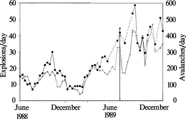 |
Figure 12. Mean daily number of explosions (crosses) and avalanches (squares) during 2-week periods at Santiaguito, as interpreted from telemetered data by INSIVUMEH, June 1988-January 1990. The 19 June 1989 eruption is marked by an arrow. |
"Significant changes have occurred on the N side of Santiaguito since July 1989 (figure 13). The El Monje dome, mostly extruded between 1947 and 1952, had developed a talus slope on its N side that was stabilized and had developed a strong moss coating that prevented rockfalls. This slope allowed access to the summit of Santiaguito throughout a long period (1964-88) and also to the 1902 crater of Santa María. Deep barrancas (canyons) have formed on the N side of the El Monje dome, cutting steep barriers into the talus slopes. These have coalesced at the edge of the talus slope, forming a large barranca between Santiaguito and Santa María that feeds an enormous amount of material into the (Isla) area farther W, and caused another deep barranca to form at the end of the Loma trail. The barrancas on the El Monje dome have deepened and migrated headward until they intersect the top of the dome. They could reflect fracturing of the El Monje dome, perhaps the weakest of three dome units that buttress the N side of the Caliente Vent. If viewed in this way the new barrancas could forecast the site of new dome extrusion from a lateral vent. The increased sediment load from this barranca system is likely to affect the Río Concepción and the Río Tambor to the south when the next rainy season arrives in April or May.
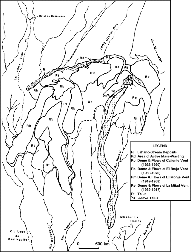 |
Figure 13. Simplified geologic map of Santiaguito Dome, 1922-February 1990. Streams near Santiaguito are approximately located. Unit dates, such as Rc (1922-90), represent periods of discontinuous activity at each vent. Patterned areas represent very recent activity: Rl - area of active laharic and stream deposition, and very high aggradation rates; Rd - area of recently initiated extensive mass wasting indicating inflation of the El Monje vent area and potential reactivation of the vent; Rc (v pattern) - active block lava flows on Caliente's summit, with very common (hourly) collapse of the broad toe resulting in hot rock avalanches; Rc (dotted pattern) - extent of the 1986-88 block lava flow from Caliente. |
"Fieldwork was also directed at examination of the areas affected by the 19 July 1989 eruption (figure 14). The outline of a distinct blast zone, marked by tree blowdown, was mapped. A collapse scarp facing the blast zone was observed. This shows conclusively that partial domal collapse accompanied the 19 July 1989 eruption (14:07)."
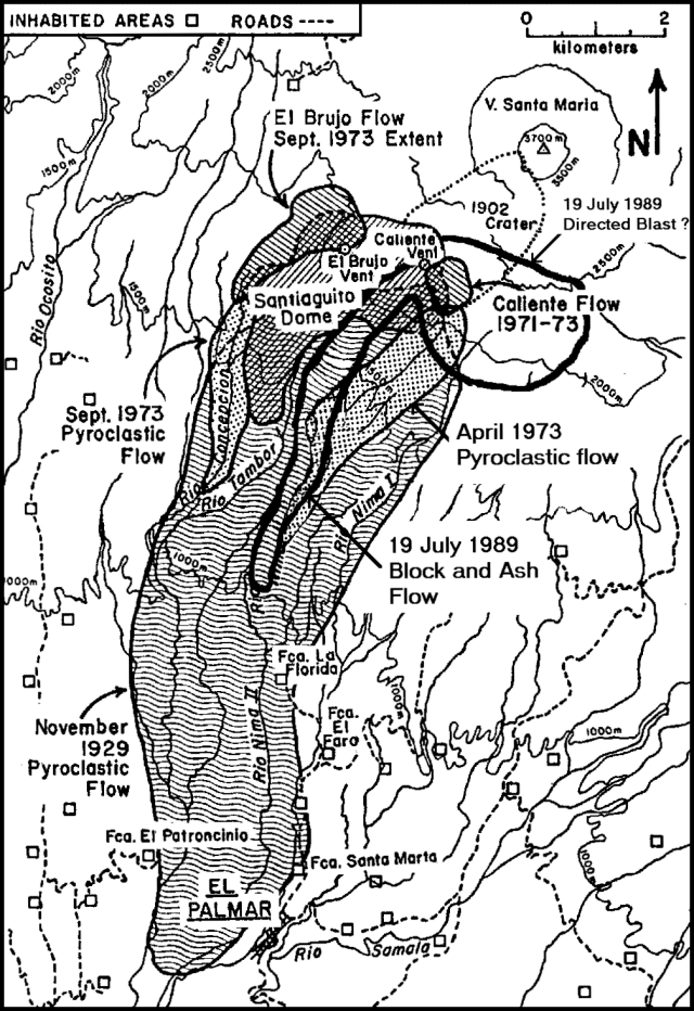 |
Figure 14. Map of Santiaguito and vicinity, showing the zones affected by the 1929, 1973, and 1989 pyroclastic flows. The 1989 and April 1973 deposits have similar areas but different sources. Modified from Rose, 1987. |
Reference. Stoiber, R.E., Malinconico, L.L. Jr., and Williams, S.N., 1983, Use of the correlation spectrometer at volcanoes, in Tazieff, H. and Sabroux, J.C., eds., Forecasting Volcanic Events; Elsevier, Amsterdam, p. 425-444.
Geological Summary. Symmetrical, forest-covered Santa María volcano is part of a chain of large stratovolcanoes that rise above the Pacific coastal plain of Guatemala. The sharp-topped, conical profile is cut on the SW flank by a 1.5-km-wide crater. The oval-shaped crater extends from just below the summit to the lower flank, and was formed during a catastrophic eruption in 1902. The renowned Plinian eruption of 1902 that devastated much of SW Guatemala followed a long repose period after construction of the large basaltic andesite stratovolcano. The massive dacitic Santiaguito lava-dome complex has been growing at the base of the 1902 crater since 1922. Compound dome growth at Santiaguito has occurred episodically from four vents, with activity progressing E towards the most recent, Caliente. Dome growth has been accompanied by almost continuous minor explosions, with periodic lava extrusion, larger explosions, pyroclastic flows, and lahars.
Information Contacts: O. Matías and R. Morales, INSIVUMEH; W.I. Rose, J. Diehl, R. Andres, F.M. Conway, and G. Keating, Michigan Technological Univ; J. Fink and S. Anderson, Arizona State Univ.