Report on Redoubt (United States) — April 1990
Bulletin of the Global Volcanism Network, vol. 15, no. 4 (April 1990)
Managing Editor: Lindsay McClelland.
Redoubt (United States) Continued lava dome growth and small explosive events
Please cite this report as:
Global Volcanism Program, 1990. Report on Redoubt (United States) (McClelland, L., ed.). Bulletin of the Global Volcanism Network, 15:4. Smithsonian Institution. https://doi.org/10.5479/si.GVP.BGVN199004-313030
Redoubt
United States
60.485°N, 152.742°W; summit elev. 3108 m
All times are local (unless otherwise noted)
This report, from the AVO staff, covers the period 15 April-15 May, 1990. Information about the 15 April explosive episode supplements the initial material in 15:3.
"Lava dome growth punctuated by small explosive events and partial dome collapse continued to occur. In general, seismic and explosive activity were at relatively low levels (figure 11). Intense steaming in the crater area coupled with poor weather have limited viewing of the dome and crater area to 5 observations during the report period. The pattern of explosive eruptions every 3-9 days that had characterized Redoubt's activity from 15 February to 21 April has changed; as of mid-May, the last significant explosive event had occurred on 21 April, 3.5 weeks earlier.
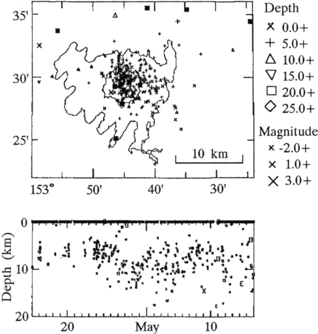 |
Figure 11. Epicenter map (top) and depth vs. time plot (bottom) of earthquakes recorded near Redoubt by AVO, 15 April-15 May 1990. Squares on the epicenter map mark the positions of seismic stations. Near-summit stations are obscured by numerous seismic signals. |
Explosive episode, 15 April. "A moderate explosive event occurred at 1440 and was recorded for 8 minutes at the Spurr station. The explosive event triggered a pyroclastic flow down the N face of the volcano, and a mudflow that carried hot blocks of dense dome rock 1-2 m in diameter 4 km downvalley (to the E end of the Dumbbell Hills; figure 12). A small flood reached the Drift River oil facility about 3 hours after the onset of the episode (about 40% occupied the Drift River channel, the rest the Rust Slough and Cannery Creek channels). Winds carried the tephra N-NW from Redoubt; flat discs of pumice up to 4 cm in diameter were noted about 10 km NW of the vent area. Three cloud-to-ground lightning strikes were detected NW of the volcano.
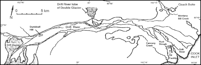 |
Figure 12. Sketch map of the Drift River valley and related drainages on the NE flank of Redoubt. The Drift River oil facility is between the mouth of the Drift River and Rust Slough. Courtesy of AVO. |
Explosive episode, 21 April. "A small to moderate explosive event occurred at 0611 and was recorded for 4 minutes at the Spurr station. An ash-laden plume was reported to 7.5-9 km and a disc-shaped 'collar' was observed at about half that altitude by personnel at the Drift River oil facility and residents of the Kenai Peninsula. Light ashfalls occurred N-NW of the volcano to about 75 km distance. Heavy steaming prevented good observations of the crater area, but it was apparent that at least some of the lava dome remained in the crater. The episode triggered a small pyroclastic flow and surge. No significant flooding was associated with this episode.
Minor explosive events. "A small seismic event that occurred on 26 April at 1017 was recorded for 2 minutes at Spurr station. An AVO field crew reported an ash plume rising above the volcano and heading SE. Light ashfall reached 100 km SE of the mountain. The episode included a small pyroclastic flow that terminated at about 1,000 m on the N flank. The summit area was partially obscured by clouds, but it appeared that about 80% of the dome was intact and was still oversteepened to the N. An overhanging slab extended from the dome's NE rim; collapse of a similar slab may have triggered the pyroclastic flow. No flooding in the Drift River valley accompanied the event.
"A seismic event on 7 May at 1846 was too small to be recorded at Spurr, but pilots reported a plume to 9.5 km, consisting mostly of steam with a little ash. No pyroclastic flows were reported to have been associated with the event, and no hot blocks were noted by an AVO crew in the field the next day; however, poor weather prevented observations above 750 m altitude. A dusting of ash (presumably from the 7 May event) was seen on the upper flanks on 10 May.
Dome observations. "The dome was only observed five times during the report period, on 21, 25, 26, and 28 April, and 5 May. Thus, no views of the dome were obtained between the explosive episodes on 15 and 21 April, nor since the small explosive event on 7 May. The crater area was exceptionally clear on 25 and 28 April, and in both viewings the dome had a rough, blocky surface with transverse tension cracks exhibiting a smooth, massive interior. On 25 April, the dome was oval in plan, but by the 28th it was elongate N-S and oversteepened on its N side. Blocky talus that covered the canyon floor for a couple of hundred meters N of the dome on 28 April was not observed on the 25th. When the dome was last viewed on 5 May, it was partially obscured by steam and low clouds, but the surface was definitely smooth and massive, not rough and blocky."
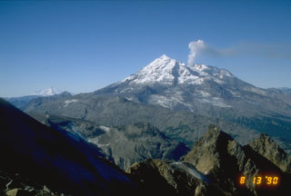
Geological Summary. Redoubt is a glacier-covered stratovolcano with a breached summit crater in Lake Clark National Park about 170 km SW of Anchorage. Next to Mount Spurr, Redoubt has been the most active Holocene volcano in the upper Cook Inlet. The volcano was constructed beginning about 890,000 years ago over Mesozoic granitic rocks of the Alaska-Aleutian Range batholith. Collapse of the summit 13,000-10,500 years ago produced a major debris avalanche that reached Cook Inlet. Holocene activity has included the emplacement of a large debris avalanche and clay-rich lahars that dammed Lake Crescent on the south side and reached Cook Inlet about 3,500 years ago. Eruptions during the past few centuries have affected only the Drift River drainage on the north. Historical eruptions have originated from a vent at the north end of the 1.8-km-wide breached summit crater. The 1989-90 eruption had severe economic impact on the Cook Inlet region and affected air traffic far beyond the volcano.
Information Contacts: AVO Staff.