Report on Piton de la Fournaise (France) — May 1990

Bulletin of the Global Volcanism Network, vol. 15, no. 5 (May 1990)
Managing Editor: Lindsay McClelland.
Piton de la Fournaise (France) Dike injection, then eruption from fissure vents near S caldera wall
Please cite this report as:
Global Volcanism Program, 1990. Report on Piton de la Fournaise (France) (McClelland, L., ed.). Bulletin of the Global Volcanism Network, 15:5. Smithsonian Institution. https://doi.org/10.5479/si.GVP.BGVN199005-233020
Piton de la Fournaise
France
21.244°S, 55.708°E; summit elev. 2632 m
All times are local (unless otherwise noted)
The following supplements 15:4. After ~15 days of increased seismicity (figure 25) an eruption began on 18 April at 1250. That morning, four low-energy (duration <10 seconds) summit earthquakes were detected between 0605 and 0654. At 0706, seismic activity increased suddenly, and a swarm of ~40 events, most with durations of 5-35 seconds, occurred within 20 minutes. A summit seismic crisis began at 0726, with almost continuous summit shocks (roughly every 10 seconds).
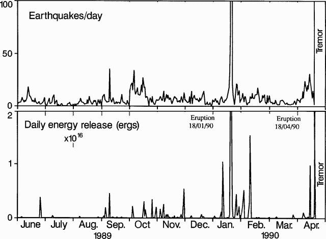 |
Figure 25. Number of earthquakes (top) and daily seismic energy release (bottom) at Piton de la Fournaise, June 1989-April 1990. |
Summit-area tilt stations began to record considerable deformation at about 0730. Geologists used tilt vectors from the three summit stations to estimate the position of the inflation center, and documented its migration at 1- or 5-minute intervals, depending on the intensity of deformation (figure 26). Deformation centers seemed to be located below the E part of Dolomieu Crater from 0730 to 0745, then migrated rapidly SE from 0745 to 0751, at a calculated velocity of ~2.3 m/s, probably related to dike injection. Deformation then appeared to reverse to a general summit deflation as the dike continued to move SE.
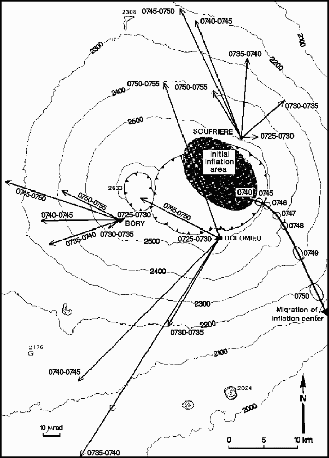 |
Figure 26. Map of the summit area of Piton de la Fournaise showing migration of the inflation center, calculated using tilt vectors from the Dolomieu, Bory, and Soufriere stations. |
The intensity of the summit seismic crisis decreased at 0759, and most of the recorded events had progressively lower frequencies, with the last typical high-frequency shock recorded at 0803. Low-frequency seismicity continued until 1250, associated after 1142 with four high-frequency shocks. One of the latter (at 1151) was centered in the Grandes Pentes area. Generalized tremor indicated that eruptive vents opened at 1250, but poor weather prevented any direct observations.
Geologists from the OVPDLF and the Univ de la Réunion arrived at the eruption site the next day at about 1100. A new fissure ~150 m long, trending roughly 170°, included about five small spatter cones 5-10 m high, but none of the vents remained active. Vigorous lava fountaining, 30-50 m high, was occurring from a cone ~30 m high (Catherine N. Crater, figure 27) at the S end of the fissure. A lava lake was visible inside the crater, feeding flows into two main channels at an estimated output rate of 20-30 m3/s. Temperature of the lava 30 m downslope was ~1,110°C. Lava flowed onto the Grand Brûlé area, covering 0.925 x 10⁶ m2 with a calculated volume of ~ 5 x 10⁶ m3 by the 20th. This yielded an average output rate of 19 m3/s, in general agreement with field estimates. By the end of the eruption, lava covered a surface area of 1.52 x 10⁶ m2 with a volume of 8 x 10⁶ m3. The lava was an aphyric basalt that appeared identical to products of the 18-19 January eruption.
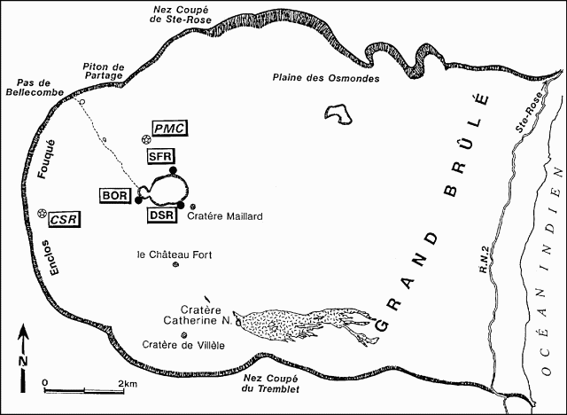 |
Figure 27. Sketch map of the Enclos Fouque caldera at Piton de la Fournaise, showing Catherine N. crater and the area covered by April-May 1990 lava. Filled circles mark tilt stations, open circles with stars indicate magnetic stations. |
SO2 degassing from Catherine N. Crater was observed and aerosols were collected, but no high-temperature vents could be accessed for direct magmatic gas sampling. Magnetic changes were also associated with the eruption. Mean daily magnetic intensity differences between a station on the N flank of Dolomieu Crater (PMC) and a reference station (CSR) showed a clear decreasing trend.
Tremor decreased during the morning of 19 April to about half of the previous day's values, and remained at a low level after the 20th. On 25 April, lava fountains were considerably lower (~10 m high) and lava output rate was very low. Because of the decreasing output rate, lava flowed into tubes, emerging 0.5-1 km downslope. The eruption stopped on 8 May at about 2300.
Geological Summary. Piton de la Fournaise is a massive basaltic shield volcano on the French island of Réunion in the western Indian Ocean. Much of its more than 530,000-year history overlapped with eruptions of the deeply dissected Piton des Neiges shield volcano to the NW. Three scarps formed at about 250,000, 65,000, and less than 5,000 years ago by progressive eastward slumping, leaving caldera-sized embayments open to the E and SE. Numerous pyroclastic cones are present on the floor of the scarps and their outer flanks. Most recorded eruptions have originated from the summit and flanks of Dolomieu, a 400-m-high lava shield that has grown within the youngest scarp, which is about 9 km wide and about 13 km from the western wall to the ocean on the E side. More than 150 eruptions, most of which have produced fluid basaltic lava flows, have occurred since the 17th century. Only six eruptions, in 1708, 1774, 1776, 1800, 1977, and 1986, have originated from fissures outside the scarps.
Information Contacts: J-P. Toutain and P. Taochy, OVPDLF; P. Bachelery, Univ de la Réunion; J-L. Cheminée, IPGP; observations and data interpretation were also carried out byL. Fontaine, P. Kowalski, A. Legros, E. Piquot, and P. Piquemal, and field support was provided byA. Gerente.