Report on Unzendake (Japan) — August 1990

Bulletin of the Global Volcanism Network, vol. 15, no. 8 (August 1990)
Managing Editor: Lindsay McClelland.
Unzendake (Japan) Seismicity declines slightly
Please cite this report as:
Global Volcanism Program, 1990. Report on Unzendake (Japan) (McClelland, L., ed.). Bulletin of the Global Volcanism Network, 15:8. Smithsonian Institution. https://doi.org/10.5479/si.GVP.BGVN199008-282100
Unzendake
Japan
32.761°N, 130.299°E; summit elev. 1483 m
All times are local (unless otherwise noted)
Seismicity declined in August, but remained at high levels (345 earthquakes) . . . . Five earthquakes were felt [at UWS] and 56 tremor episodes were recorded (an increase from 11 in July). Tremor amplitude ranged from 0.2 to 0.9 [µm] (figure 4).
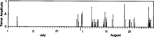 |
Figure 4. Amplitude of volcanic tremor at Unzen, July-August 1990. Courtesy of JMA. |
Geological Summary. The massive Unzendake volcanic complex comprises much of the Shimabara Peninsula east of the city of Nagasaki. An E-W graben, 30-40 km long, extends across the peninsula. Three large stratovolcanoes with complex structures, Kinugasa on the north, Fugen-dake at the east-center, and Kusenbu on the south, form topographic highs on the broad peninsula. Fugendake and Mayuyama volcanoes in the east-central portion of the andesitic-to-dacitic volcanic complex have been active during the Holocene. The Mayuyama lava dome complex, located along the eastern coast west of Shimabara City, formed about 4000 years ago and was the source of a devastating 1792 CE debris avalanche and tsunami. Historical eruptive activity has been restricted to the summit and flanks of Fugendake. The latest activity during 1990-95 formed a lava dome at the summit, accompanied by pyroclastic flows that caused fatalities and damaged populated areas near Shimabara City.
Information Contacts: JMA.