Report on Nevado del Ruiz (Colombia) — August 1990

Bulletin of the Global Volcanism Network, vol. 15, no. 8 (August 1990)
Managing Editor: Lindsay McClelland.
Nevado del Ruiz (Colombia) Frequent ash emission with associated tremor; ashfall to 30 km; hot springs described
Please cite this report as:
Global Volcanism Program, 1990. Report on Nevado del Ruiz (Colombia) (McClelland, L., ed.). Bulletin of the Global Volcanism Network, 15:8. Smithsonian Institution. https://doi.org/10.5479/si.GVP.BGVN199008-351020
Nevado del Ruiz
Colombia
4.892°N, 75.324°W; summit elev. 5279 m
All times are local (unless otherwise noted)
Ash emissions were reported during May, July, and August, frequently with associated tremor. Tremor intensity and the number of high- and low-frequency earthquakes fluctuated, roughly corresponding with increased explosive activity. SO2 flux was moderate with the exception of high fluxes recorded during June, and the geochemistry of the hydrothermal system remained unchanged from December 1988.
Ash emissions. Ash was emitted on seven days during May (5, 6, 8, 12, 14, 17, and 24), deposited primarily to the N, NW, and W. On 14 May, ash was reported falling in Manizales (25 km W of the volcano) from 1120 to 1530 with an average cumulative thickness of 0.43 g/m2. No ash was reported during June, but five small ash emissions were reported during July, with a total accumulation of 500 g/m2 at Refugio (2.0 km NW of the crater). The largest emission, on 25 July, deposited ash 30 km from the volcano. The deposits, 2 mm thick at Refugio, were composed exclusively of lithic material. Several small ash emissions were also reported during August.
Volcanic tremor. Tremor was frequently associated with the ash emissions (and with long-period events in August), and its frequency of occurrence and intensity roughly corresponded with the frequency and intensity of ash emissions. During May and July, tremor was more frequent and more intense; the reduced displacement was 3.2 cm2 on 12 May, 2.85 cm2 on 14 May, 3.05 cm2 on 22 May, and reached 3.5 cm2 in July (these were considered moderate to below moderate levels for Ruiz). During June and August when there was little or no ash emission activity, reduced displacements were 0.32 cm2 on 9 June, 0.88 cm2 on 26 June, and <1.0 cm2 in August. During May-August, tremor episodes had periods of 0.1-0.5 seconds (0.15-0.4 seconds during August) and originated at <1 km depth. These episodes usually occurred in pulses with durations of 5-15 minutes, but occasionally were continuous (13-15 May and the end of August).
A second type of tremor, characterized as low-intensity and short-duration, has been noted at Ruiz. It is considered to be from a deeper source and is not associated with ash emissions. During July it originated W of the crater at >=1 km depth.
Other seismicity. Seismic activity increased during May with 1,326 high-frequency and 1,982 low-frequency recorded earthquakes (up from 579 and 1,580 respectively in April). Of these, 247 high- and 156 low-frequency earthquakes, occurred during a swarm on 31 May. The earthquakes were centered in three clusters; NE of, SW of, and under the crater, aligned with the Palestina fault, and at depths from 0.5 to 4.5 km. During June, 1,664 high- and 1,422 low-frequency earthquakes of M <= 2.8 were recorded, at depths of 0.5-12 km. Epicenters were aligned with and transverse to the Palestina Fault. Seismicity increased during July, with mainly long-period earthquakes and bursts of seismicity consisting of many high- and low-frequency earthquakes occurring in trains. The earthquakes were located around the crater at depths of 0.5-5.0 km. A swarm of 400 earthquakes (M <=2.6), with three felt shocks at the onset, were recorded over a 6-hour period on 28 August (figure 37). The swarm was located NE of the crater with focal depths < 1.5 km (figure 38).
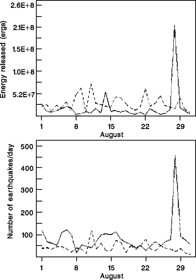 |
Figure 37. Seismicity at Ruiz, August 1990. Solid line, high-frequency events; dashed line, low-frequency events. Courtesy of INGEOMINAS. |
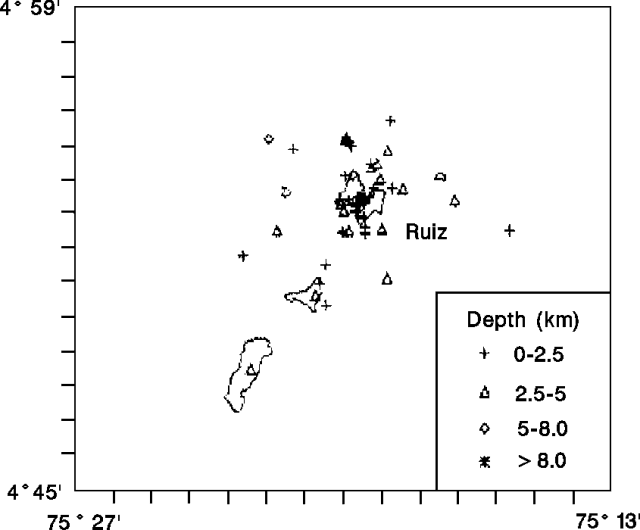 |
Figure 38. Epicenters of high-frequency earthquakes at Ruiz, August 1990. Courtesy of INGEOMINAS. |
Deformation. Deformation continued to be monitored at Ruiz using a network of dry-tilt and EDM stations; one new EDM station was added to the network in June near the Bis seismic station (at 5,030 m, almost 6 km NW of the crater). A few short-term episodes of moderate deformation were noted during May, but no significant deformation was detected during June-mid-August. On 13 August, the Refugio EDM station showed a rapid 100-µrad displacement (figure 39), but this did not correspond with any other recognized changes in activity (seismic, geochemical, or deformational) at the volcano.
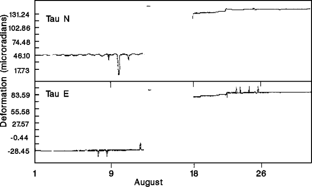 |
Figure 39. Deformation at Refugio EDM station, Ruiz, August 1990. Courtesy of INGEOMINAS. |
Measurement of topographic controls on the summit glaciers indicated a decrease in ablation in June with respect to April and May.
Plume geochemistry. COSPEC monitoring indicated a decrease in SO2 flux following high levels in June. The monthly average SO2 flux was 1,519 t/d in May (11 measurements with a range of 367-3,869 t/d), 5,985 t/d in June (three measurements, 5,208-7,498 t/d), 1,097 t/d in July (six measurements, 406-2,672 t/d), and 2,437 t/d in August (figure 40).
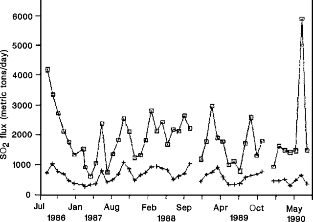 |
Figure 40. Monthly average SO2 flux from Ruiz, 1988-90. Upper line is calculated with measured wind data; lower line without wind data. Courtesy of INGEOMINAS. |
Geochemistry of the hydrothermal system. The following is by S. Williams, S. Schaefer, and José Vasquez.
"The large white gas column continues to boil continuously from Ruiz. We visited and sampled hydrothermal springs between 11 and 16 August. The geochemistry of all of the sites has been studied and is reported in Sturchio and others (1988) and Williams and others (1990). His isotopic data are reported in Sano and others, 1990. The Azufrera Nereidas gas vent, located in the Nereidas valley at 3,575 m elevation, had maximum temperatures of 86°C. Gas release appeared to be unchanged from the previous visit in December 1988. The hot spring, located in the river canyon below the gas vent, was found to have temperatures of 51°C and pH of 6.1. The flow rate was estimated to be between 1 and 5 liters/minute. Abundant sulfur deposition is evident at the spring. In Botero Londoño hotspring, at 15 km distance and 2,450 m elevation, spouting hot water had a maximum temperature of 95°C and pH of 7.6. The springs closest to the crater, Río Gualí (at 3 km and 4,670 m) had a maximum temperature of 57°C and pH of ~3.8. These are located within ~50 m of the tongue of the glacier in the Gualí valley. Aguas Calientes, at 7 km and 3,780 m elevation, was found to be unchanged from the previous visit (December 1989) with a maximum temperature of 61°C and pH of 1.6. Other hot springs sampled in July included El Recodo and the Hotel Termales del Ruiz. El Recodo, a bicarbonate spring, had a temperature of 60°C and pH of 7.8, unchanged from measurements made in December 1986. The Hotel is a strong acid-sulfate-chloride spring with a temperature of 64°C and pH of 1.1."
References. Sano, Y., Wakita, H., and Williams, S.N., 1990, Helium isotope anomaly in Nevado del Ruiz volcano, Colombia: implications for volcanic hydrothermal system: JVGR, v. 42, p. 41-52.
Sturchio, N.C., Williams, S.N., García P., N., and Londoño C., A., 1988, The hydrothermal system of Nevado del Ruiz Volcano, Colombia: BV, v. 50, p. 399-412.
Williams, S.N., Sturchio, N.C., Calvache, M.L., Mendez, R., Londoño C., A., and García P., N., 1990, Sulfur dioxide flux from Nevado del Ruiz volcano, Colombia: total flux and isotopic constraints on its origin: JVGR, v. 42, 53-68.
Geological Summary. Nevado del Ruiz is a broad, glacier-covered volcano in central Colombia that covers more than 200 km2. Three major edifices, composed of andesitic and dacitic lavas and andesitic pyroclastics, have been constructed since the beginning of the Pleistocene. The modern cone consists of a broad cluster of lava domes built within the caldera of an older edifice. The 1-km-wide, 240-m-deep Arenas crater occupies the summit. The prominent La Olleta pyroclastic cone located on the SW flank may also have been active in historical time. Steep headwalls of massive landslides cut the flanks. Melting of its summit icecap during historical eruptions, which date back to the 16th century, has resulted in devastating lahars, including one in 1985 that was South America's deadliest eruption.
Information Contacts: C. Carvajal and F. Cruz, INGEOMINAS, Manizales; S. Williams and S. Schaefer, Louisiana State Univ; J. Vasquez, Beloit College.