Report on Eldey (Iceland) — August 1990

Bulletin of the Global Volcanism Network, vol. 15, no. 8 (August 1990)
Managing Editor: Lindsay McClelland.
Eldey (Iceland) Strong seismicity SW of May 1989 swarm; possible new lava in 1989 swarm area
Please cite this report as:
Global Volcanism Program, 1990. Report on Eldey (Iceland) (McClelland, L., ed.). Bulletin of the Global Volcanism Network, 15:8. Smithsonian Institution. https://doi.org/10.5479/si.GVP.BGVN199008-371022
Eldey
Iceland
63.733°N, 23°W; summit elev. 70 m
All times are local (unless otherwise noted)
A 9 September earthquake swarm has been located on the Reykjanes Ridge, site of a large number of earlier swarms, including one in May-June 1989 (Nishimura and others, 1989, and 14:5). Bergman and Solomon (1990) made a detailed analysis of spatial, temporal, and other characteristics of Mid-Atlantic Ridge earthquake swarms detected by worldwide seismic networks. Their results indicated that the swarms are tectonic in origin, and not representative of volcanic activity, although not necessarily exclusive of it. Work by Shor et al. (1990) suggests that there has been recent volcanic activity at the site of the May 1989 swarm, potentially concurrent with the swarm activity.
A joint venture of the Hawaii Institute of Geophysics (Alex Shor and Clyde Nishimura) and the Naval Research Laboratory (Peter Vogt and Michael Czarnecki), aboard the RV Ewing (Lamont-Doherty Geological Observatory), visited the May 1989 swarm site during July (S,hor et al., 1990). Simultaneous SeaMARCII sidescan imagery and Hydrosweep multibathymetry was used to examine a 1,000 km2 area of the seafloor at depths ranging from 700 to 1,350 m. Gravity and magnetics studies were also conducted.
A probable young lava flow was identified, centered near 59.47°N, 29.43°W, within the error radius of sonobuoy-based epicenter locations from the May 1989 swarm. The apparent lava flow (roughly 4 x 2 km) extends from the E margin of the neo-volcanic zone (NVZ) S over sedimented and faulted terrain and is bounded on the E by an inward-facing normal fault with an 80 m throw. The region is heavily faulted (faults are W-facing, spaced
During the investigation of the Reykjanes Ridge, the Ewing followed and surveyed the ridge axis from 52.8°N to 63.0°N. More than 100 discrete volcanic cones were identified within one 65-km-long, 10-km-wide strip, with many additional cones on the flanks.
On 9 September, six earthquakes were recorded originating near 56.7°N and 34.4°W (table 1), about 500 km SW along the ridge from the May 1989 swarm (figure 2). Preliminary planning and requests have been made to conduct an airborne sonobuoy mission similar to that employed during the May 1989 swarm. Pre-swarm seafloor imaging of the site was obtained during the July ridge axis survey. A second Ewing mission to the site of the May 1989 swarm (Lindsay Parson, Institute of Oceanographic Sciences, U.K.), had already been planned for October and should complete "before and after" views of the September swarm site.
Table 1. Earthquake epicenters and magnitudes for Reykjanes Ridge earthquakes, 9 September 1990. Courtesy of the USGS National Earthquake Information Center.
| Time | Location | Magnitude (mb) |
| 0017 | 56.94°N, 34.29°W | 5.0 |
| 0030 | 56.1°N, 34.5°W | 4.8 |
| 0215 | 56.78°N, 34.37°W | 5.5 |
| 0625 | 56.60°N, 34.33°W | 5.2 |
| 0635 | 56.65°N, 34.59°W | 5.1 |
| 1235 | 56.75°N, 34.38°W | 4.8 |
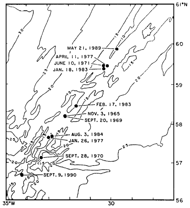 |
Figure 2. Locations of earthquake swarms on the Reykjanes Ridge, after Bergman and Solomon (1990). The approximate site of the September 1990 swarm has been added. |
References. Bergman, E.A., and Solomon, S.C., 1990, Earthquake swarms on the Mid-Atlantic Ridge: products of magmatism or extensional tectonics?: JGR, v. 95, p. 4943-4965.
Nishimura, C.E., Vogt, P.R., Smith, L., and Boyd, J.D., 1989, Investigation of a possible underwater volcanic eruption on the Reykjanes Ridge by airborne sonobuoys and AXBT's (abs.): Eos, v. 70, p. 1301.
Shor, A.N., Nishimura, C.E., Czarnecki, M., and Vogt, P.R., 1990, Lava extrusion from the 1989 Reykjanes Ridge seismic swarm? probably yes (SeaMARCII) (abs.): Eos, v. 71 (Fall AGU Abstract Volume).
Geological Summary. The Eldey volcanic system is located on the northernmost part of the Reykjanes Ridge and is submarine with the exception of Eldey Island and the skerries (small rocky islands) Eldeyjardrangur, Geirfugladrangur, and Geirfuglasker. Maximum water depth within the system is about 250 m. Eldey has been moderately active in Holocene time. Characteristic activity consists of explosive submarine basaltic eruptions. Six small eruptions have been located within this system during the last 1,100 years, the last occurring in 1926 CE.
Information Contacts: R. Stefánsson, Icelandic Meteorological Office; P. Vogt, Naval Research Laboratory; B. Presgrave, NEIC.