Report on Izu-Oshima (Japan) — September 1990
Bulletin of the Global Volcanism Network, vol. 15, no. 9 (September 1990)
Managing Editor: Lindsay McClelland.
Izu-Oshima (Japan) Small ash eruption; new collapse pit formed
Please cite this report as:
Global Volcanism Program, 1990. Report on Izu-Oshima (Japan) (McClelland, L., ed.). Bulletin of the Global Volcanism Network, 15:9. Smithsonian Institution. https://doi.org/10.5479/si.GVP.BGVN199009-284010
Izu-Oshima
Japan
34.724°N, 139.394°E; summit elev. 746 m
All times are local (unless otherwise noted)
A small eruption occurred at Mihara-yama cone on 4 October, the first since January 1988. A burst of summit earthquakes started at 0319 and two larger shocks were recorded at 0346 and 0347 (figure 20). Weak, lithic ashfall (no magmatic material was identified) occurred from around 0400 to 0445, thinly covering the N half of the island. Press sources reported that the column reached 1,200 m. The number of earthquakes declined toward evening, and a brief, weak emission of reddish ash was observed at 1400. Steam emission, vigorous on the 4th, decreased to normal by the following day.
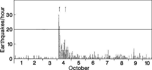 |
Figure 20. Hourly number of earthquakes at Oshima, 1-10 October 1990. Arrows at top of figure mark eruptions. Courtesy of JMA. |
A visit to the crater on 9 October revealed the presence of a new collapse pit in the N part of the crater floor (figure 21). The pit was 100 m across at the rim and 50 m in diameter more than 100 m down (the total depth is not known). Steam rose from the pit and several small collapses along the walls produced brownish clouds. The estimated total volume of the erupted ash (a few to ten thousand tons estimated weight) could not account for the total volume of the new pit. Geologists believed the collapse occurred at around 0346, coincident with the two recorded shocks. The main crater, 400 m across at the rim, 200 m at the floor, and 150 m deep, was formed by collapse during an eruption on 18 November 1987.
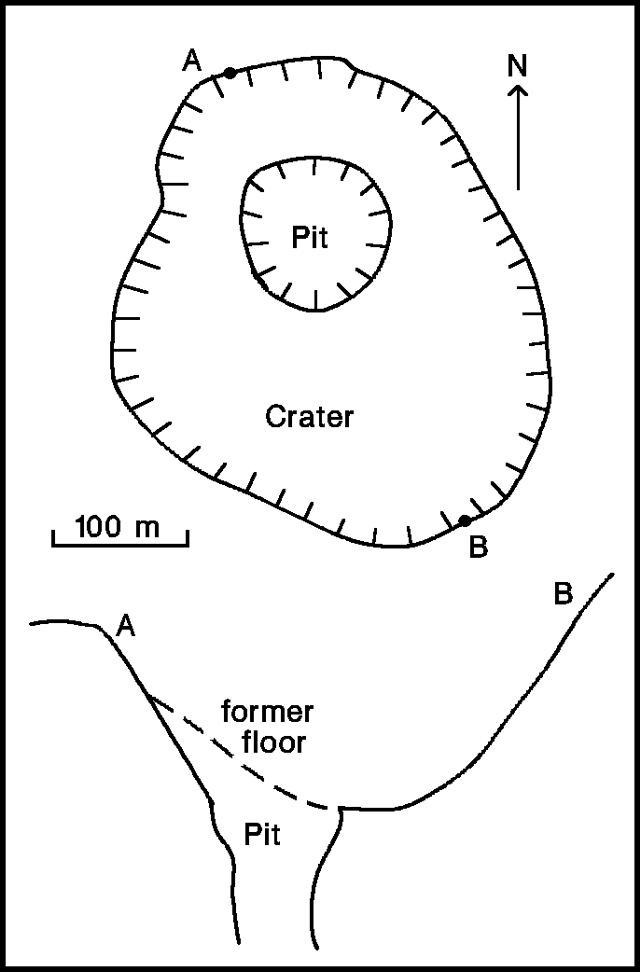 |
Figure 21. Sketch map and cross section of the crater at Oshima, 9 October 1990. Courtesy of JMA. |
No deformation was detected before or after the eruption, and no tremor episodes were recorded. Seismicity decreased to pre-eruption levels by 13 October.
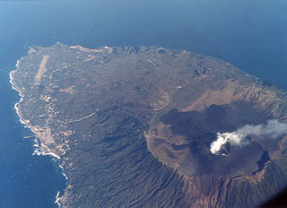
Geological Summary. Izu-Oshima volcano in Sagami Bay, east of the Izu Peninsula, is the northernmost of the Izu Islands. The broad, low stratovolcano forms an 11 x 13 km island constructed over the remnants of three older dissected stratovolcanoes. It is capped by a 4-km-wide caldera with a central cone, Miharayama, that has been the site of numerous recorded eruptions datining back to the 7th century CE. More than 40 cones are located within the caldera and along two parallel rift zones trending NNW-SSE. Although it is a dominantly basaltic volcano, strong explosive activity has occurred at intervals of 100-150 years throughout the past few thousand years. A major eruption in 1986 produced spectacular lava fountains up to 1,600 m high and a 16-km-high eruption column; more than 12,000 people were evacuated from the island.
Information Contacts: JMA.