
Non-eruptive May 2010 surface deformation from inferred deep instrusion
Oshima is an active volcano located on the northern tip of the Izu-Bonin volcanic arc. Our last report of activity at Oshima (BGVN 21:08) enumerated a flurry of shallow low-frequency earthquakes beneath the top and W flank of the volcano that started on 5 August 1996.
Since those relatively benign events, the Japan Meteorological Agency (JMA) had not observed any subsequent events worthy of note until May 2010 when land surface inflation was detected. The inflation was registered by a strainmeter, a Global Positioning System (GPS) network (run by the Geospatial Information Authority of Japan, GSI), and a tiltmeter network (run by the National Research Institute for Earth Science and Disaster Prevention, NIED).
In July 2010 seismicity in the shallow parts of and around Oshima began to increase. (High seismicity synchronous with inflation of the edifice was seen earlier, including in 2004 and 2007). These events were considered to be due to magma intrusion into the deeper part of the volcano. There were no remarkable changes in surface phenomenon. In September, the inflation that was detected in May began declining. Seismicity in the shallow parts of and around Oshima continued at a low level with some small earthquakes which temporally increased in the western offshore areas of Oshima on 22 December 2010.
The earthquakes increased in frequency again on 9 February 2011. GPS and strainmeter measurements indicated contraction since January, but the trend reversed to show inflation in October 2011. Seismicity remained at a low level. Very low level gas emissions were sometimes observed by a camera positioned on the NW summit. Based on a field survey on 28 October, no remarkable change in surface phenomena was observed.
No remarkable activity has been noted since October 2011. Throughout the noted activity, JMA held the Alert Level at 1.
Information Contacts: Japan Meteorological Agency (JMA), Otemachi, 1-3-4, Chiyoda-ku Tokyo 100-8122, Japan (URL: http://www.jma.go.jp/).
The Global Volcanism Program has no Weekly Reports available for Izu-Oshima.
Reports are organized chronologically and indexed below by Month/Year (Publication Volume:Number), and include a one-line summary. Click on the index link or scroll down to read the reports.
Earthquake swarm on 14-15 January
Card 1342 (24 January 1972) Earthquake swarm on 14-15 January
"Volcan Izu-Osima had been quiet since a small quantity of ashfall was observed around Miharayama summit crater in April 1971. A sudden earthquake swarm, however, occurred last week as follows: A swarm of volcanic earthquakes including 27 felt shocks (maximum intensity in JMA was IV) took place on 14 January 1972, at Osima Island, Izu Islands, Japan. This swarm started at about 1530 and faded away at about 0600 on 15 January (JST time). 183 earthquakes were recorded on the seismograph at the Osima Weather Station during this period, and intensities (JMA scale) of felt shocks were as follows: IV - three times; III - four times; II - seven times; I - 13 times.
"A small cliff collapse was reported, but no other damage. No abnormal volcanic phenomena appeared at Miharayama summit crater on this insular volcano and the state of the summit crater is now calm."
Information Contacts: Seismological Division, Japan Meteorological Agency.
Earthquake swarm in late October through mid-November
An earthquake swarm [W] of Oshima Island, accompanied by subterranean rumbling, began in late October and was continuing in mid-November (table 1). Similar earthquake swarms occurred in January 1972 and November 1973. Ten minor explosive eruptions have occurred at Oshima since 1962, the latest [in 1974].
Table 1. Number of felt and recorded earthquakes at Oshima, 30 October-17 November 1977. [JMA replaced the data in the original table.]
| Date | Felt Earthquakes | Recorded Earthquakes |
| 30 Oct 1977 | 1 | 79 |
| 31 Oct 1977 | 1 | 217 |
| 04 Nov 1977 | 3 | 43 |
| 15 Nov 1977 | 3 | 86 |
| 16 Nov 1977 | 4 | 243 |
| 17 Nov 1977 | 3 | 242 |
Further Reference. Yamashina, K., and Nakamura, K., 1978, Correlations between tectonic earthquakes and volcanic activity of Izu-Oshima volcano, Japan: JVGR, v. 4, p. 233-250.
Information Contacts: T. Tiba, National Science Museum, Tokyo.
Fatal earthquake causes landslides and tsunami; volcanism unchanged
JMA submitted the following description of renewed seismic activity.
A large earthquake shook central Japan at 1224 on 14 January 1978. The epicenter was about 10 km W of Oshima island, focal depth was 0 km, and the magnitude was 7.0. A severe shock of intensity 5 (on the JMA scale of 0-7) (figure 1) was felt at JMA's Oshima Weather Station. The earthquake killed 25 persons, injured 139, and totally destroyed 94 houses and damaged 539 others in the Izu Peninsula and Oshima island. In the Izu Peninsula, numerous landslides and rockfalls blocked roads and railways, and destroyed many houses. On Oshima island, houses were destroyed or damaged mainly by strong earthquake motion. Weak tsunami waves were generated. The highest was 70 cm (peak to peak) at Okada port on Oshima island. Aftershocks occurred in a narrow belt elongated from Oshima island to the W (figure 2). Volcanism at Oshima volcano was not affected by the earthquake.]
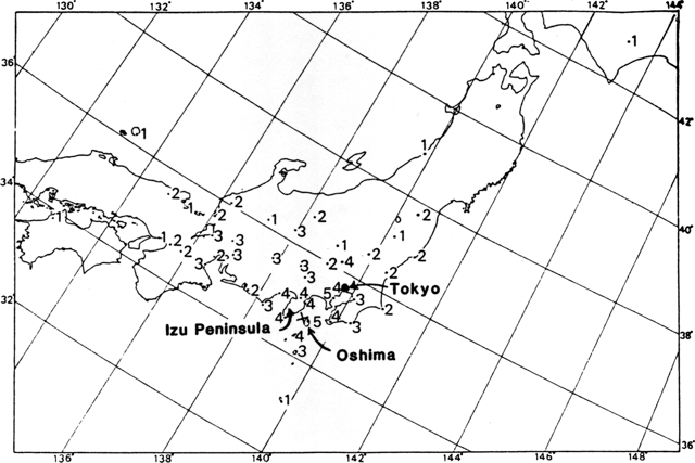 |
Figure 1. Distribution of seismic intensities (JMA scale of 0-7) from the earthquake near Oshima at 1224 on 14 January 1978. Courtesy of JMA. |
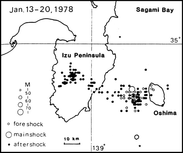 |
Figure 2. Distribution of foreshocks and aftershocks of the Oshima earthquake at 1224 on 14 January 1978. Courtesy of JMA. |
Information Contacts: JMA.
Tremor and earthquake swarm but no change in thermal activity
On 20 July, JMA seismic stations on Oshima Island began to record volcanic tremor for the first time in 12 years. Tremor, recorded regularly every 2 hours, continued through early September. Event durations were about 10-30 minutes and amplitude was ~0.5 µm at station A, which at 1 km NNW of the active summit cone (Mihara) is the nearest of the five JMA seismic stations. No significant change in the volcano's weak fumarolic activity was observed by field surveys in the crater on 1, 4, and 18 August.
A 10-hour earthquake swarm occurred during the morning of 21 August. Three of the events were felt at the weather station ~5 km NNW of the summit. As in previous episodes of seismicity, epicenters were on the N part of the island, 4-5 km NNE of the summit crater.
Information Contacts: JMA.
More earthquakes; continued tremor; rumbling
A seismic station ~5 km N of the crater recorded 354 earthquakes in September, a marked increase from 41 in August (table 2). Nine events were felt at the Oshima weather station in September, the largest a M 4.0 shock accompanied by rumbling on 11 September at 2146. Earthquake swarms were recorded 11-13 and 26-27 September, with epicenters on the W and N coasts of the island respectively. Volcanic tremor with maximum amplitude of 0.7-0.8 µm continued throughout the month.
Table 2. Number of local earthquakes recorded by a seismic station about 5 km N of the crater at Oshima, April-September 1986. Courtesy of JMA.
| Month | Earthquakes |
| Apr 1986 | 695 |
| May 1986 | 24 |
| Jun 1986 | 21 |
| Jul 1986 | 10 |
| Aug 1986 | 41 |
| Sep 1986 | 354 |
The previous earthquake swarms were redorded in 1877, 1983, and most recently 16-24 August 1985, when almost 300 events with a maximum magnitude of 2.9 occurred just beyond the NW part of the somma.
Information Contacts: JMA.
Eruption column to 3,200 m after four months of seismicity
[Preliminary press information in this report is superseded by data from geologists in 11:11]. An eruption from the central crater (Mihara-yama) began the evening of 15 November. An eruption column rose 3200 m above the summit. Small eruptions were continuing the next day, sending ejecta to 500 m. Ash fell over an extensive area. By the morning of 19 November a 5-lobed lava flow had destroyed an observatory tower and Shinto shrine near the crater rim, and was moving down the NW flank at ~1 m/hour. By midday the flow was ~50 m long. "Lava" was ejected to 500 m above the summit and ash rose more than 1.5 km. In the mid-afternoon of 21 November, a 600-m-long fissure opened, extruded lava that flowed toward populated areas, and sent ejecta to about 1,100 m height. Thousands of residents and tourists in 5 communities N and W of the crater were forced to evacuate. Forty forest fires were reported and domestic flights were rerouted to avoid the volcano. Damage to crops was estimated at $1.2 million, but no casualties were reported.
UPI reported that JMA recorded 19 earthquakes with epicenters in the ocean, 10 km from Oshima, on the second day of the eruption. The strongest (4 on the JMA intensity scale of 7) occurred that evening at 1846. AP reported that by 19 November more than 150 submarine events had been recorded. Seventy more recorded earthquakes that began at 1417 on 21 November preceded the fissure opening. One event registered 5 and at least two registered 4 on the JMA intensity scale.
Information Contacts: UPI; AP.
Lava from summit vent and two fissures; epicenters plot along NW/SE axis; 12,000 evacuated; summit deflated before eruption
Phase 1 (15-19 November). A vigorous eruption began at 1718 on 15 November. The first phase, lasting 4 days, produced almost continuous lava fountains up to 500 m high (200-300 m average) and a lava lake within the crater of the 1777 cinder cone (Mihara-yama; vent A in figure 3). About 14 x 104 metric tons of scoria fell SE of vent A on 16 November and 1 x 10⁴ metric tons SW of the vent the next day. The lava lake overflowed the crater rim at 0955 on 19 November, sending a flow 0.6 km W before Phase 1 ended at 2320. A total of 1.3 x 10⁶ m3 (33 x 106 metric tons) of lava were erupted at a rate of 1.3 x 10⁴ m3/hour during the first phase.
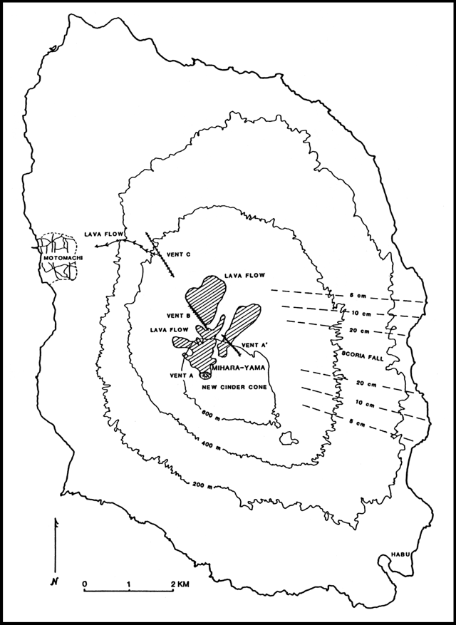 |
Figure 3. Sketch map showing Oshima's new cinder cone, vents, lava flows, and scoria fall. Contour interval is 200 m. Courtesy of the Earthquake Research Institute. |
Phase 2 (21-24 November). After less than 2 days of quiet, the second phase began at 1615 on 21 November. A fissure opened 1.2 km NNW of the crater, on the caldera floor (B on figure 3) and produced lava fountains, flows, and a 9-10-km-high eruption cloud. Flows moved mostly NE and were ~1 km long by 2000. An en-echelon fissure opened a few tens of meters from B at 1627. Scoria fall from vent B extended E and had a maximum thickness of >20 cm, 3.5 km from the vent (figure 3). The first eruptive activity outside the 3 x 4 km caldera began at 1746, from a 1.5-km-long fissure (C) NW of the caldera rim. Lava fountains and flows emerged, feeding a 1.5-km-long flow that soon advanced to within 1 km of Motomachi, the island's main town, on the W coast. At 2100 lava fountaining declined; two hours later ashfall reached the Boso Peninsula, 50 km NE. Eruptive activity weakened by dawn, and by 0600 ashfall had declined. Total Phase 2 ashfall was 500,000 m3. The mass evacuation of Oshima's 10,200 residents and 2,000 tourists the night of 21-22 November was the largest operation of its kind during a natural disaster in Japan; it was completed in less than 12 hours using 39 vessels.
At 0700 on 22 November, lava production began from vent A' on the NE flank of the 1777 cinder cone; lava flowed <1 km NE. On 23 November at 1330, lava began to emerge from the S part of fissure B, advancing about 0.5 km to the NE. By 1800, steam from vents A and A' was the only evidence of eruptive activity. The volcano was quiet by 25 November.
By 24 November a 3-km-long fissure had formed on the SE part of the island (near Habu port), oriented in the same NW-SE direction as the other newly formed fissures, but no eruptve activity was observed. The lava flow that threatened Motomachi had stopped 200 m from the town as of 25 November. An occasional column of steam to ~30 m above the summit was reported on 28 November.
Eruptive activity resumed at 0547 on 18 December with a 2-hour episode that produced 800-m-high ash columns, lava fountains, and at least one series of explosions. Fifty of the 800 residents that had returned to the island gathered at a local high school. The remainder of the residents, who were still at 34 school gyms and other facilities in central Tokyo, had been scheduled to return 19 December.
The total volume of November lava was ~18 x 106 m3, and scoria and ash volume was 1.9 x 10⁶ m3. Preliminary petrologic data indicated that scoria from Phase 1 contained ~53% silica. Samples of scoria, lava flows, and bombs from Phase 2 contain ~54-57% silica. One sample of pumice collected from the E side of the island contains ~61% silica.
Seismicity. From January to the beginning of October, seismic activity was mainly distributed in the northern and western parts of the island, generally at levels of <40 recorded events (M <3) per day with occasional peaks of more than 100 events/day. Seismicity dropped to very low levels in October, and continued at low levels until 15 November.
Seismicity rapidly increased just after noon on 16 November, 19 hours after the eruption began, and reached a peak at 1846 the same day. The number of recorded events/hour fluctuated between 0 and 13, totalling 48 on 17 November, 40 on the l8th, and 9 on the l9th, dropping to near 0 after 0900. The largest events in Phase 1 had magnitudes of 3.9 (at 1846 on 16 November) and 4.1 (at 1455 on 18 November). Epicenters of Phase 1 events were in two broad zones roughly 4-7 km wide that extended N and W of the summit caldera (figure 4). Most events were located closer to the coast than to the summit caldera.
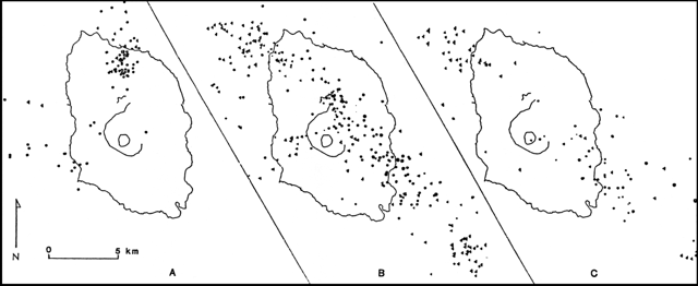 |
Figure 4. Plots of earthquake epicenters at Oshima, courtesy of the Earthquake Research Institute: a) 1725, 15 November-1200, 21 November; b) 0000, 22 November-1415, 28 November; c) 0000, 1 December-0320, 7 December. |
Seismicity increased just after 1400 on 21 November, about two hours before the start of Phase 2. The number of recorded events peaked at the same time as the onset of Phase 2, when ~80/hour, including seven with M > 4, were recorded. Seismicity dropped sharply to near zero within a few days after the conclusion of the eruption on 23 November.
Phase 2 epicenters on 22 November (following the most active part of the eruption) were primarily in a NW-SE-trending zone (figure 4), roughly 3 km wide, centered ~1.5 km NE of the rift zone where Phase 2 eruptions occurred. Early Phase 2 epicenters have not yet been located because of crowded seismic records. Shallow events (<5 km) were concentrated near the vents at the summit of the island, while deeper events (>5 km) were concentrated near the NW and SE coasts and offshore.
Epicenters on 1-9 December were concentrated along the same zone as those of Phase 2 (figure 4), close to the coastline, with shallow events occurring close to the SE coast.
Episodic tremor began on 7 July, more than 18 weeks before the eruption began. Pulses lasted 10-20 minutes at regular intervals of approximately 3 hours until 20 July. Tremor amplitude increased several times during the months before the eruption. The pattern became more irregular at about the beginning of October, then tremor suddenly stopped on 27 October. Continuous tremor started several days later.
A higher amplitude episodic tremor was superimposed on the continuous tremor every 1-2 hours beginning on the morning of 15 November. At the onset of Phase 1 that afternoon, tremor amplitude increased significantly and the characteristic period became significantly longer. Tremor stopped as Phase 1 ended on 19 November at 2320.
Episodic tremor resumed the evening of 20 November. At about noon on 21 November, tremor became continuous, then stopped about 1-2 hours before the onset of Phase 2 at 1615. During Phase 2, tremor was not distinguished; it may have been masked by the high seismicity.
Ground deformation. Prior to the eruption, levelling surveys had been conducted at 3-10-year intervals along the two roads leading to the summit (the 1777 scoria cone). The points near the caldera were remeasured on an annual basis. Results indicate that the summit was deflating before the eruption, with ~40 mm of displacement measured from 1983 to 1986 near the center of the summit cone. Between April 1984 and August 1986, electronic distance measurements across the caldera showed contraction, consistent with deflation.
Before the eruption, a continuously recording tiltmeter near the SE end of the island showed a tilt direction consistent with deflation of the summit region. Tilt accelerated at the start of Phase 1. Between phases 1 and 2, tilt was approximately constant. At the beginning of Phase 2, however, tilt quickly reversed, gradually became flat, then returned to the original direction of movement by about noon on 22 November.
Data from a continuously recording volumetric strainmeter on the NW part of the island indicated that contraction started about July 1981 and continued until the eruption. Contraction accelerated with Phase 1 (consistent with the direction and trend of the tiltmeter on the SE part of the island) then became flat. When Phase 1 ended, expansion began then sharply accelerated 2 hours before the beginning of Phase 2.
The data indicated that expansion continued for nearly all of Phase 2 and ended about 2000 on 21 November, after which a gradual contraction was recorded. Expansion similar to that seen on the Oshima strainmeter, but two orders of magnitude smaller, was seen on strainmeters on the Izu Peninsula; this expansion continued for a few days after the eruption at a lesser rate.
Information Contacts: Y. Hayakawa, S. Aramaki, Y. Ida, H. Watanabe, K. Yamaoka, and H. Glicken, Earthquake Research Institute, Univ of Tokyo; Y. Sawada, JMA.
Small explosions one day after tremor resumes
"A brief eruption on 18 December was followed by relative quiet through 13 February . . . . Volcanic tremor was recorded on 17 December from 0915 to 0921 for the first time since the late November eruption. Tremor recurred at 1519 and 2139, lasting for 5 minutes each time; amplitudes were about equal to those of the first episode. The next day, six tremor episodes, lasting 4-6 minutes each, occurred at ~2-hour intervals prior to 1645, when continuous pre-eruption tremor began. Steady tremor continued until 1723 when amplitude increased abruptly, saturating the signal at most seismographs on the island.
"The summit was obscured by bad weather but the eruption probably began around 1725 when an observer heard a weak noise on the N slope. Frequent explosions (up to 10/minute) were heard between 1731 and 2000, and air shocks were felt at Motomachi, 4 km away. Incandescent fragments were seen being ejected from the summit crater during a brief break in the clouds. The eruption probably ended around 1930, based on the amplitude of large tremors, but an isolated explosion occurred at 2121.
"The eruption scattered a small number of bombs on the S slope of the summit cinder cone (Mihara-yama) but no lava flows were observed during air and ground surveys. Ejecta volume is estimated at 2 x 10³ tons, compared with 5 x 10⁷ tons during the November eruption.
"Tremor activity resumed on 1 January, occurring at 1-3-hour intervals 1-8 January [but see 12:04] and 1-hour intervals 9-22 January. Periods of tremor lasted 5-10 minutes; amplitudes were the same as on 17 and 18 December (figure 5). From 22 to 25 January, the interval between periods of tremor increased to 2 hours and amplitude doubled. Continuous tremor began the night of 25 January, showing a much smaller amplitude than the periodic tremor. On 4 February periodic tremor emerged again, and as of 13 February was continuing with an amplitude similar to that of mid-January. The source of periodic tremor appeared to be below Mihara-yama cone. The periodic tremor was accompanied by a change in rock strain of 0.4-2.0 x 10⁻⁸ detected by a borehole-type strainmeter 5 km N of Mihara-yama. Step-like changes in ground tilt were detected by a tiltmeter 2 km N of Mihara-yama simultaneous with the beginning of periodic tremor in February [see also 12:4]. Tilt indicated uplift of the summit during tremor.
 |
Figure 5. Amplitude of volcanic tremor vs. time at Oshima, 1 January-8 February 1987. Courtesy of JMA. |
"Other activity was quiet or steady. Every day a weak steam cloud rose 5-10 m above the northern slope craters (formed during the fissure eruption in November). Steam emission from Mihara-yama was steady and weak. Seismicity declined steadily from December to February. Microearthquakes occurred in a belt extending NNW-SSE past the summit area and into the sea. No shocks were felt in January and February although two events were felt in Motomachi in December (one was a M 3.0 on 27 December). Numerous tiltmeters and a strainmeter showed no anomalous change of trend except for the short-duration changes caused by periodic tremor mentioned above."
Information Contacts: JMA.
Steam emission; tremor and strain changes; earthquake swarms
Since the 18 December explosion, no additional eruptive activity has been reported. Steam jets rose daily to 10 m above some of the November fissures and white clouds usually extended 50 m above the summit.
Seismicity declined steadily after the November eruptive event and continued to decline through March. There was no change in the distribution of epicenters, which were concentrated in a zone trending NNW-SSE on the island. Volcanic tremor resumed on 1 January, after 10 days of quiet, occurring at almost regular 1-hour intervals (figure 6) [but see 12:1]. Periodic tremor had declined by February but continued at [January] amplitudes. Durations of tremor episodes ranged from 10 to 30 minutes. The tremor source (estimated from amplitude at each seismometer) appeared to be below the central cone (Mihara-yama).
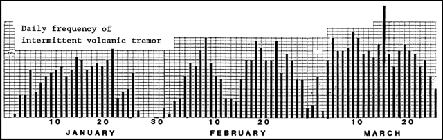 |
Figure 6. Daily frequency of intermittent volcanic tremor at Oshima. Courtesy of JMA. |
Periodic tremor was accompanied by step-like strain changes, recorded by a borehole strainmeter 108 m below sea level, 5 km N of Mihara-yama. Step-like expansion began on 1 January, reversing to contraction on 22 January [see also 12:1]. Other strainmeters had shown gradual contraction since the 21 November eruptive activity, before strain virtually ceased.
UPI reported that earthquake swarms began 6 May off the NW coast of the island, 10-20 km below the ocean floor. Of the 1,571 total recorded earthquakes 6-12 May [but see 12:6], 895 occurred on the 11th, the day of the largest event (M 5.1).
Information Contacts: JMA; UPI.
Earthquake swarm; no new eruptive activity
Minor earthquakes began on 6 May, centered 15 km NW of Izu-Oshima Island at ~10-20 km below sea level. More than 900 events had been recorded by 11 May, when seismicity forced Japan Railways to suspend operations in part of Chiba Prefecture E of Tokyo. The earthquakes were felt on Oshima and in Ajiro on the SE part of the Izu Peninsula. 73 events were recorded on 15 May; 140 minor shocks were recorded between 0100 and 0900 on 16 May. The earthquakes were continuing on 17 May. The largest events of the swarm had maximum intensities of 3 on the JMA scale and occurred at 1039 on 10 May, 0635 on 11 May, and 0420 on 17 May [but see 12:6]. No new eruptive activity was reported at the volcano.
Information Contacts: Kyodo radio, Tokyo.
Three earthquake swarms; intermittent tremor continues
Three earthquake swarms occurred in May. The first, 15 km NW of the island, lasted from 6 to about 20 May. It was followed by two weaker swarms; in the SE part of the volcano 22-26 May, and near the summit from 22 May to mid-June (figure 7). About 89 shocks were recorded at the Oshima weather station during the 6-20 May swarm (figure 8), the largest a M 5.1 event at 0635 on 11 May. Swarms have occurred in that area one or two times a year since 1978, most recently in October 1986.
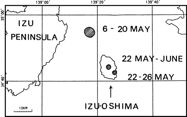 |
Figure 7. Earthquake swarms in Oshima area, May 1987. Epicentral areas are shaded. Courtesy of JMA. |
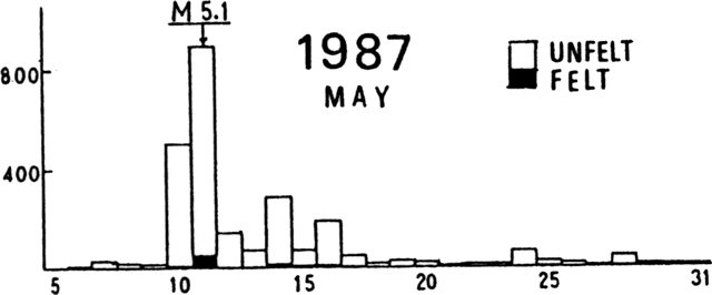 |
Figure 8. Daily seismicity of the earthquake swarm NW of Oshima, 5-31 May 1987. Courtesy of JMA. |
The 22-26 May swarm was the first increase in seismicity in the SE part of the island since the eruption. The largest event, at 0626 on 23 May, had a magnitude of 3.0 and was felt at the weather station. Seismicity in the SE part of the island had decreased steadily and exponentially since the 1986 eruption (figure 9).
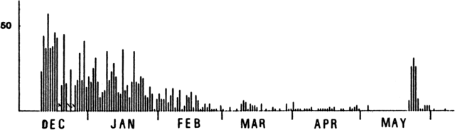 |
Figure 9. Daily seismicity in SE part of Oshima Island, 10 December 1986 to 10 June 1987. Courtesy of JMA. |
An increase in summit-area microearthquakes also began on 22 May. Recorded events increased from about 20/day February-May, to ~40/day after 22 May, and to 100 daily after 29 May; the number of events decreased in mid-June. Steady microearthquake activity had continued near the summit since February, when observation by seismograph began in the area (figure 10). Tremor that began 1 January was intermittently recorded throughout May and June. Tremor episodes generally occurred at regular intervals of 1-2 hours and lasted for about 30 minutes. Beginning 14 May their regularity decreased, intervals between episodes grew from several hours to 20 hours, and episode durations increased to 60-300 minutes (figure 11). The regular tremor interval resumed on 7 June but toward the end of June became irregular again. Long-duration tremor episodes of more than 10 hours were often recorded. Weak steam emission continued at the summit of Miharayama, the central cone, producing about 50-m plumes. Steam rose steadily 0-5 m from craters that had formed on the N-flank fissure in the 1986 eruption.
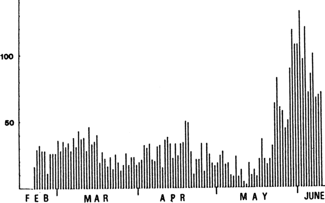 |
Figure 10. Daily seismicity in the summit area of Oshima, 20 February-10 June 1987. Courtesy of JMA. |
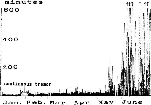 |
Figure 11. Duration of volcanic tremor at Oshima, January-June 1987. Courtesy of JMA. |
Information Contacts: JMA.
Volcanic tremor; small earthquakes below summit
Intermittent volcanic tremor occurred during July. Durations of tremor episodes generally ranged from a few minutes to 2 hours but episodes lasting more than 10 hours were sometimes recorded. Small earthquakes with foci under the summit area were registered at a rate of ~40/day by the seismograph N of the summit caldera. A steam plume rose continuously to ~50 m above the summit crater.
Information Contacts: JMA.
Intermittent volcanic tremor; summit-area earthquakes
Small earthquakes beneath the summit cone increased from 20 September through the end of the month. The number of daily earthquakes registered by the seismograph in the summit crater reached a maximum of 136 on 2 October, about twice the number of the late September period. Two other increases, in May [12:6] and August, have been recorded since February.
Intermittent volcanic tremor occurred at a rate of 3-14 episodes/day during September. Episode duration generally ranged from 20 to 100 minutes, but often exceeded 2 hours. Tremor amplitude showed no change during the month. Steam rising from five summit-area vents was observed during a field survey 7-8 September. A steam plume rose continuously to ~50 m above the summit.
Information Contacts: JMA.
Renewed explosions; ash to 2,500 m; tourists evacuated
On 16 November at 1047 an eruption began with two explosions that sent a black ash and gas column to at least 2,500 m above the summit. Small eruptions continued every 5-10 minutes. Roads leading to the mountain were closed and about 150 tourists and others in the summit area were evacuated to a hotel on the N side of the crater at 1100. Heavy ashfall occurred on the S part of the island and more than 30 volcanic clasts fell near a shrine on the crater rim causing several small fires. A window was broken at a tea house near the crater but there were no reports of casualties or major damage. JMA recorded >1,000 small earthquakes before the eruption, and weak earthquakes continued afterwards. During an earthquake swarm in early October [12:9] the maximum daily number of recorded earthquakes reached twice the previous maximum for 1987.
The JMSA and the Japan Maritime Self-Defense Force (JMSDF) mobilized patrol boats and escort vessels off the island.
Information Contacts: A. Izumo, Yokohama Science Center; Japan Times, Tokyo; UPI.
Explosions after increased seismicity and new fumaroles
Small explosions began in the crater of the summit cinder cone (Mihara-yama) at 1047 on 16 November. Bombs were ejected to 1.6 km distance, instruments in the summit area were damaged, and nearby windows were cracked. The sounds were heard from as far as the Honshu mainland (at least 30 km away). The crater was obscured by clouds, but within the next hour aerial observers saw eruption columns rising to 5,000 m height. Tephra fell primarily to the E, and totaled a few thousand metric tons. Explosions were heard at irregular intervals until 1546. At about 1700, a lava fountain a few meters high was observed within the crater, but no flows formed. The next day, observations indicated that the crater floor had subsided 25 m since before the eruption.
Summit glow was observed at 0329 on 18 November, and ashfall to the SW soon followed. At about 0500, a gray ash column rose an estimated 1,600 m. Five hours later, at 1004, there were a few small explosions and a small amount of ash fell to the NW. Small eruption columns were observed until evening. The next day, helicopter observations indicated that the crater floor had subsided an additional 150 m [but see 13:1]. From 19 to 27 November, plumes a few hundred meters high occasionally rose from Mihara-yama. On 21 November, 5,200 of the 10,000 Oshima Island residents participated in evacuation drills that used six ships, 20 planes, and 145 motor vehicles. A white plume was the only activity at the volcano that day.
The groundmass of the ejecta contained abundant microphenocrysts of pyroxene and plagioclase. This suggested to volcanologists that the rock was not fresh magma, but was derived from the lava lake that has been cooling inside Mihara-yama crater since the November 1986 eruption.
Seismicity. Seismicity in the summit region had been gradually increasing since January 1987 (figure 12). A significant peak at the end of September 1987 was not accompanied by eruptive activity. Seismicity rapidly increased in the middle of November, reaching 543 events/day on 13 November and 586 on 14 November. Within a few days after the eruption on 16 November, seismicity rapidly declined to <50 events/day.
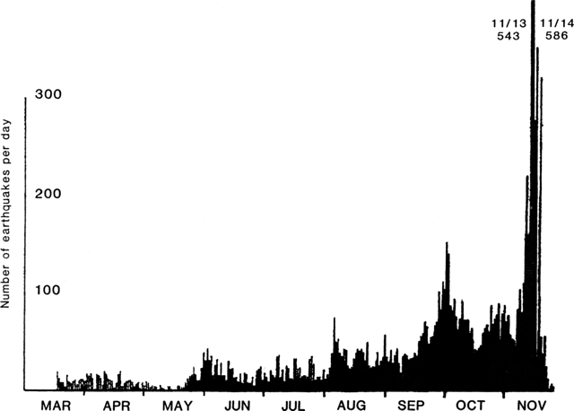 |
Figure 12. Number of earthquakes per day in the summit region of Izu-Oshima island, May-November 1987. Courtesy of Earthquake Research Institute, Univ of Tokyo. |
Seismographs installed in the summit area two weeks before the eruption showed that the earthquakes were very shallow (less than ~400 m depth), and almost entirely confined to the area underneath the summit crater. Periods of both episodic and continuous tremor occurred in the months before the eruption. Tremor became continuous just before the eruption.
Ground deformation. Levelling and tilt data suggested that almost the entire summit region of Oshima has been subsiding since the November 1987 eruption. No clear ground deformation precursors were seen prior to the eruption. A stepwise change at all tiltmeters around the island occurred almost simultaneously with the start of the second series of eruptions at 0329 on 18 November (figure 13). The change is consistent with a center of inflation roughly 5 km NW of Mihara-yama. The volumetric strainmeter in the NW part of the island recorded an expansion consistent with the tilt (figure 13).
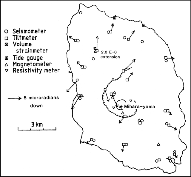 |
Figure 13. Map showing monitoring instrumentation on Izu-Oshima Island. Vectors show downward direction and magnitude of stepwise change in tilt, 18 November at 0326. |
Fumarolic activity. A clear increase in fumarolic activity was noted before the eruption. A ring of fumaroles around the summit cone was observed at the end of July, and the activity of this ring increased with time. A second ring formed around the first ring in November. Fumarolic activity increased rapidly 5-10 days before the eruption.
Further References. Abe, K. and Takahashi, M., 1987, Description of the November 21, 1986 fissure eruption on the caldera floor of Izu-Oshima volcano, Japan: analysis of a series of photographs: Bulletin of the Earthquake Research Institute, Tokyo, v. 62, p. 149-162.
Aramaki, S., ed., 1988, The 1986-1987 eruption of Izu-Oshima volcano: Earthquake Research Institute, University of Tokyo, 61 p. (9 papers).
Endo, K., Chiba, T., Taniguchi, H., Sumita, M., Tachigawa, S., Miyahara, T., Uno, R., and Miyaji, N., 1988, Izu-Oshima 1986-1987 eruptions and the eruptive products: Proceedings, Kagoshima International Conference on Volcanoes, p. 119-122.
Special Issue — Oshima volcano, Izu: Journal of Geomagnetism and Geoelectricity (Terra Science Publishing Co.), v. 42, p. 139-363 (in English).
Special Issue — The 1986 eruption of Isu-Oshima volcano: Bulletin of the Geological Survey of Japan, v. 38 (1987), p. 601-753 (12 papers) (in Japanese with English abstracts and captions).
Special Issue — The 1986 eruption of Isu-Oshima volcano: Bulletin of the Volcanological Society of Japan, v. 33 (2nd series) (1988), (in Japanese with English abstracts and captions).
Watanabe, H., the 1986-1987 eruption of Izu-Oshima volcano: Proceedings, Kagoshima International Conference on Volcanoes, p. 37-40.
Information Contacts: Y. Ida, H. Watanabe, K. Yamaoka, S. Aramaki, and H. Glicken, Earthquake Research Institute, Univ of Tokyo; Kyodo radio, Tokyo.
Ash emission; more crater wall collapse
The number of earthquakes dropped to a low level after 24 November under both the summit crater (~10/day) and the E part of the island. Volcanic tremor below the summit crater ceased after an 18 November eruption, but resumed intermittently on 18 December and became continuous from 18 January. The amplitude of each tremor episode was small at first, but began increasing the evening of 5 January. The duration of each episode was several tens of minutes.
Crater floor subsidence of 175 m was associated with the November activity but the only change in summit area topography (noted during a helicopter survey on 5 January) was some further collapse of the crater wall.
Small eruptions on 25 January at 1530 and 27 January at 1425 ejected ash clouds to 300-400 m above the summit crater. Each lasted only a few minutes and they were not accompanied by air shocks or explosion sounds. Light ashfall occurred on the E side of the island. Tiltmeters detected no noticeable deformation associated with the eruptions. At other times, a white steam plume rose continuously to about 300-800 m above the crater. A 1,000-m white plume was noted on 27 January at 0900.
Information Contacts: JMA; Kyodo radio, Tokyo.
Tremor and discrete seismic events; steam emission
Continuous tremor resumed on 18 January, then became intermittent on 15 February, although its amplitude increased 27 February-6 March (figure 14). As of 5 April, tremor was continuous but of low amplitude. Earthquake activity increased sharply 3-4 March (figure 15), with most events apparently centered under the summit cone. The number of events counted by the instrument in the caldera exceeded 275 on 3 March and 502 on the 4th, but declined to a typical rate of 13/day on 6 March. A white steam plume continuously rose 300-800 m above the summit crater. On 18 March, an 1,800-m white plume was observed from the Oshima Weather Station, the highest plume seen since the 18 November 1987 eruption.
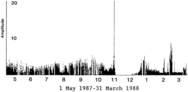 |
Figure 14. Amplitude of volcanic tremor at Oshima, 1 May 1987-31 March 1988. Courtesy of JMA. |
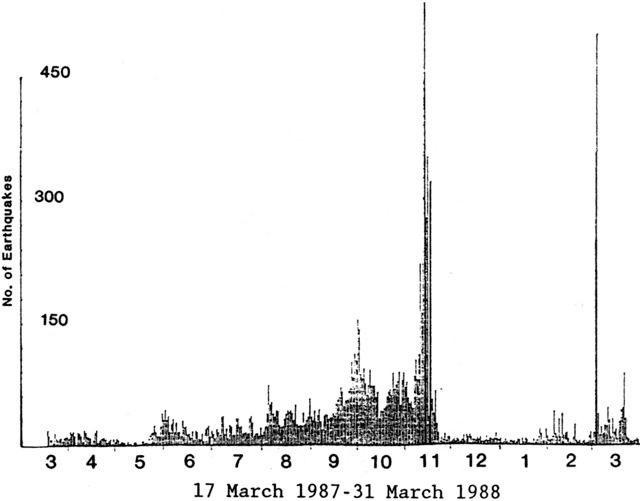 |
Figure 15. Number of earthquakes/day at Oshima, 17 March 1987-31 March 1988. Courtesy of JMA. |
Information Contacts: JMA.
Strong seismicity prompts volcanic activity warning
From late July to mid-August, numerous events clustering 10-20 km NW of Izu-Oshima Island . . . were detected at JMA's Oshima Weather Station, where 240 events were felt (figure 16a). Low-amplitude tremor was continuous. Episodes of larger amplitude tremor were superimposed at 1-hour intervals. On 21 August, the volcano emitted a white plume, its highest (1,900 m) since explosions resumed in November 1987. High levels of summit crater seismicity were recorded 19-23 August and 31 August-7 September, the last day of the report period (figure 16b). On 1 September, 423 events were recorded, the largest daily total since 3 March (502 events). The vigorous seismicity prompted the Oshima Weather Station to issue a volcanic activity warning.
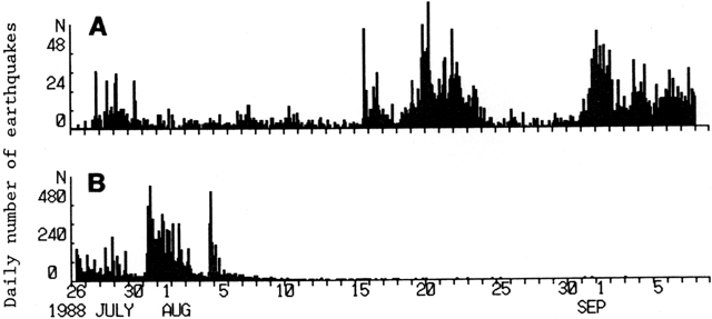 |
Figure 16. Daily number of earthquakes centered (a) at Oshima volcano and (b) E of the Izu Peninsula. Courtesy of JMA. |
Information Contacts: JMA.
Rapid decreases in steam cloud height, crater temperature, and tremor
Steam emission had gradually increased for more than 2 years and crater fumarole temperatures for at least 1 year, but fumarole temperatures began to drop in January (figure 17) and steam emission started a rapid decrease in mid-March. Steam emission had continued since the small explosions of 16-18 November 1987, when a crater, 300 m across and 150 m deep, was formed by collapse on the summit. Fumarole temperatures have been measured by infrared spot thermometry from the rim of the crater since December 1988.
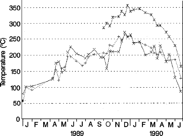 |
Figure 17. Temperatures recorded at three points in the crater of Oshima, January 1989-June 1990. Courtesy of JMA. |
Volcanic tremor, recorded almost continuously since January 1987, also began to decrease in March (figure 18). Since then, there have been few tremor events, with 10 weak tremor episodes recorded in April, and none in May or June. A M 6.5 earthquake on 20 February was centered at sea ~10 km W of the island. Aftershocks occurred along a N-S-trending line. On 1 March, a swarm of small summit-area earthquakes was recorded by a seismometer near the summit. The 1 March swarm was the most vigorous seismicity at the volcano since observations began in 1987 (figure 19). Following the swarm, seismicity on the island returned to normal levels.
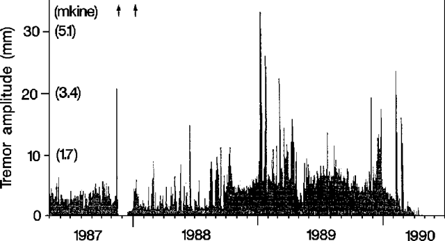 |
Figure 18. Daily maximum amplitude of volcanic tremor at Oshima, May 1987-June 1990. Arrows at top of figure mark eruptions. Courtesy of JMA. |
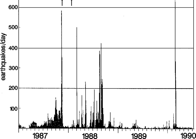 |
Figure 19. Daily number of recorded earthquakes at Oshima, January 1987-June 1990. Arrows at top of figure mark eruptions. Courtesy of JMA. |
Information Contacts: JMA.
No volcanic tremor; magnitude 2.2 earthquake on N coast
As of 8 August, volcanic tremor has not been recorded since May. A magnitude 2.2 earthquake occurred 30 July on the N coast of the island. The shock was felt (intensity II, JMA scale) at the Oshima Weather Station, and was the first felt earthquake on the island since November 1987.
Information Contacts: JMA.
Small ash eruption; new collapse pit formed
A small eruption occurred at Mihara-yama cone on 4 October, the first since January 1988. A burst of summit earthquakes started at 0319 and two larger shocks were recorded at 0346 and 0347 (figure 20). Weak, lithic ashfall (no magmatic material was identified) occurred from around 0400 to 0445, thinly covering the N half of the island. Press sources reported that the column reached 1,200 m. The number of earthquakes declined toward evening, and a brief, weak emission of reddish ash was observed at 1400. Steam emission, vigorous on the 4th, decreased to normal by the following day.
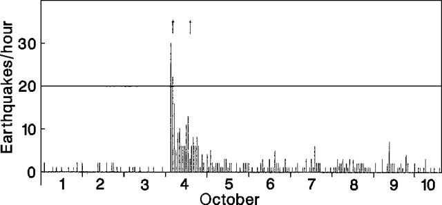 |
Figure 20. Hourly number of earthquakes at Oshima, 1-10 October 1990. Arrows at top of figure mark eruptions. Courtesy of JMA. |
A visit to the crater on 9 October revealed the presence of a new collapse pit in the N part of the crater floor (figure 21). The pit was 100 m across at the rim and 50 m in diameter more than 100 m down (the total depth is not known). Steam rose from the pit and several small collapses along the walls produced brownish clouds. The estimated total volume of the erupted ash (a few to ten thousand tons estimated weight) could not account for the total volume of the new pit. Geologists believed the collapse occurred at around 0346, coincident with the two recorded shocks. The main crater, 400 m across at the rim, 200 m at the floor, and 150 m deep, was formed by collapse during an eruption on 18 November 1987.
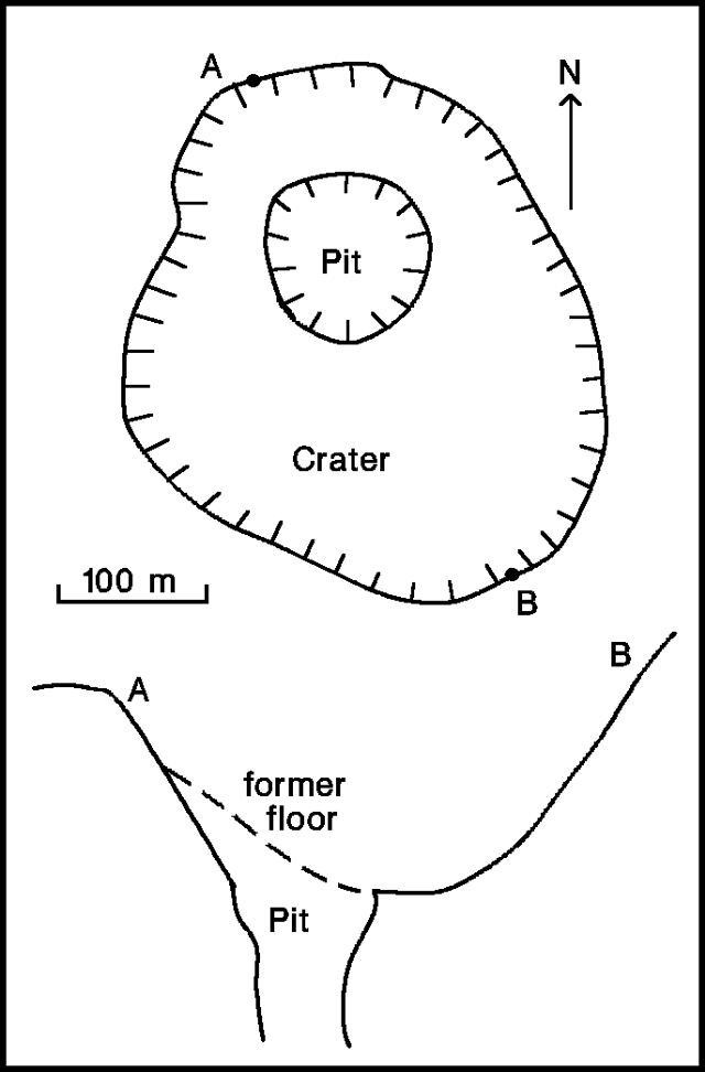 |
Figure 21. Sketch map and cross section of the crater at Oshima, 9 October 1990. Courtesy of JMA. |
No deformation was detected before or after the eruption, and no tremor episodes were recorded. Seismicity decreased to pre-eruption levels by 13 October.
Information Contacts: JMA.
Seismicity and steam emission decline
Activity decreased, following ash emissions on 4 October . . . . Seismicity and steam emission declined rapidly following the 4 October activity, and no subsequent ash emissions had occurred as of 14 November. No tremor episodes were recorded during October.
Information Contacts: JMA.
Steam emission continues but seismicity declines
Seismicity declined rapidly after . . . 4 October (figure 22). No additional eruptions had occurred as of early December. Steam emission continued steadily through November, with the plume reaching 1,300 m above the crater. A series of 10 microearthquakes, centered in the E part of Oshima Island 3 km E of the summit (Mihara-yama) cone occurred 7-10 November, the first seismicity there since 21 November 1987. Seismicity at the summit continued unchanged through November at relatively low levels. A seismometer near the summit recorded 160 earthquakes during November, down from 633 in October. Seismicity and steam emission remained similar in early December. No tremor has been recorded since late April.
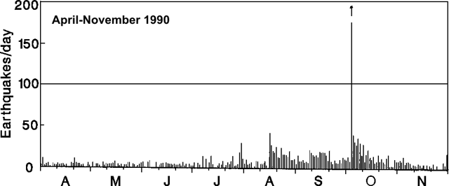 |
Figure 22. Daily number of earthquakes at Oshima, April-November 1990. The small 4 October eruption (arrow) was accompanied by high seismicity. Most of the earthquakes were centered on the summit (Mihara-yama) cone. Courtesy of JMA. |
Information Contacts: JMA.
Decreased seismicity; continued steam emissions
Steady steam emission continued following the 4 October ash emission, reaching 1,000 m above the crater (figure 23). No additional eruptions from Mihara-yama cone had occurred as of 14 January 1991. A total of 57 earthquakes were recorded in December, down from 155 in November. No tremor episodes have been recorded since late April.
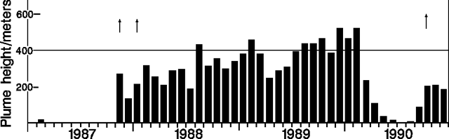 |
Figure 23. Monthly mean estimated plume heights from Oshima, 1987-90. Arrows mark eruptions. Courtesy of JMA. |
Information Contacts: JMA.
Earthquake swarm and volcanic tremor
Continuous volcanic tremor began on the evening of 30 May at the active Mihara-yama cone, reaching peak amplitude at about 2300 that day. The next night, an increase in shallow earthquake activity began in the summit area. Both the earthquake swarm and tremor had stopped by 5 June. This was the first episode of volcanic tremor recorded since April 1990. Weak and steady steaming from the Mihara-yama crater continued without change throughout the period of increased seismicity.
Information Contacts: JMA.
Minor tremor and 48 earthquakes
On 4 October, local instruments recorded volcanic tremor of short duration and small amplitude. Throughout the month a significant but undisclosed number of earthquakes occurred in the adjacent N and W coastal areas. During October there were 48 earthquakes beneath the cone.
Information Contacts: Volcanological Division, Seismological and Volcanological Department, Japan Meteorological Agency (JMA), 1-3-4 Ote-machi, Chiyoda-ku, Tokyo 100 Japan.
Seismic activity increases
On 5 August a shallow low-frequency earthquake occurred beneath the top of the volcano. On the early morning of 22 August, seismicity increased on the W flank of Oshima and 8 earthquakes were felt. At the seismic station 4 km NW of the vent (Station C), 164 earthquakes were recorded on 22 August. The largest earthquake (M 2.5) was detected at 0136 on 22 August. On 24 August an earthquake was also felt. A total of 222 earthquakes was registered at Station C in August.
Information Contacts: Volcanological Division, Japan Meteorological Agency (JMA), 1-3-4 Ote-machi, Chiyoda-ku, Tokyo 100, Japan.
Non-eruptive May 2010 surface deformation from inferred deep instrusion
Oshima is an active volcano located on the northern tip of the Izu-Bonin volcanic arc. Our last report of activity at Oshima (BGVN 21:08) enumerated a flurry of shallow low-frequency earthquakes beneath the top and W flank of the volcano that started on 5 August 1996.
Since those relatively benign events, the Japan Meteorological Agency (JMA) had not observed any subsequent events worthy of note until May 2010 when land surface inflation was detected. The inflation was registered by a strainmeter, a Global Positioning System (GPS) network (run by the Geospatial Information Authority of Japan, GSI), and a tiltmeter network (run by the National Research Institute for Earth Science and Disaster Prevention, NIED).
In July 2010 seismicity in the shallow parts of and around Oshima began to increase. (High seismicity synchronous with inflation of the edifice was seen earlier, including in 2004 and 2007). These events were considered to be due to magma intrusion into the deeper part of the volcano. There were no remarkable changes in surface phenomenon. In September, the inflation that was detected in May began declining. Seismicity in the shallow parts of and around Oshima continued at a low level with some small earthquakes which temporally increased in the western offshore areas of Oshima on 22 December 2010.
The earthquakes increased in frequency again on 9 February 2011. GPS and strainmeter measurements indicated contraction since January, but the trend reversed to show inflation in October 2011. Seismicity remained at a low level. Very low level gas emissions were sometimes observed by a camera positioned on the NW summit. Based on a field survey on 28 October, no remarkable change in surface phenomena was observed.
No remarkable activity has been noted since October 2011. Throughout the noted activity, JMA held the Alert Level at 1.
Information Contacts: Japan Meteorological Agency (JMA), Otemachi, 1-3-4, Chiyoda-ku Tokyo 100-8122, Japan (URL: http://www.jma.go.jp/).
|
|
||||||||||||||||||||||||||||
There is data available for 99 confirmed eruptive periods.
1990 Oct 4 - 1990 Oct 4 Confirmed Eruption (Explosive / Effusive) VEI: 2
| Episode 1 | Eruption (Explosive / Effusive) | Mihara-yama (1987 summit crater) | ||||||||||||||||||||||||||||||||||||||||||||||||
|---|---|---|---|---|---|---|---|---|---|---|---|---|---|---|---|---|---|---|---|---|---|---|---|---|---|---|---|---|---|---|---|---|---|---|---|---|---|---|---|---|---|---|---|---|---|---|---|---|---|
| 1990 Oct 4 - 1990 Oct 4 | Evidence from Observations: Reported | ||||||||||||||||||||||||||||||||||||||||||||||||
|
List of 8 Events for Episode 1 at Mihara-yama (1987 summit crater)
|
|||||||||||||||||||||||||||||||||||||||||||||||||
1987 Nov 16 - 1988 Jan 27 Confirmed Eruption (Explosive / Effusive) VEI: 2
| Episode 1 | Eruption (Explosive / Effusive) | Mihara-yama | ||||||||||||||||||||||||||||||||||||||||||||||||||||||||||||||||||||||||||||||
|---|---|---|---|---|---|---|---|---|---|---|---|---|---|---|---|---|---|---|---|---|---|---|---|---|---|---|---|---|---|---|---|---|---|---|---|---|---|---|---|---|---|---|---|---|---|---|---|---|---|---|---|---|---|---|---|---|---|---|---|---|---|---|---|---|---|---|---|---|---|---|---|---|---|---|---|---|---|---|---|
| 1987 Nov 16 - 1988 Jan 27 | Evidence from Observations: Reported | ||||||||||||||||||||||||||||||||||||||||||||||||||||||||||||||||||||||||||||||
|
List of 14 Events for Episode 1 at Mihara-yama
|
|||||||||||||||||||||||||||||||||||||||||||||||||||||||||||||||||||||||||||||||
1986 Nov 15 - 1986 Dec 18 Confirmed Eruption (Explosive / Effusive) VEI: 3
| Episode 1 | Eruption (Explosive / Effusive) | Mihara-yama, N part and NW of caldera | |||||||||||||||||||||||||||||||||||||||||||||||||||||||||||||||||||||||||||||||||||||||||||||
|---|---|---|---|---|---|---|---|---|---|---|---|---|---|---|---|---|---|---|---|---|---|---|---|---|---|---|---|---|---|---|---|---|---|---|---|---|---|---|---|---|---|---|---|---|---|---|---|---|---|---|---|---|---|---|---|---|---|---|---|---|---|---|---|---|---|---|---|---|---|---|---|---|---|---|---|---|---|---|---|---|---|---|---|---|---|---|---|---|---|---|---|---|---|---|
| 1986 Nov 15 - 1986 Dec 18 | Evidence from Observations: Reported | |||||||||||||||||||||||||||||||||||||||||||||||||||||||||||||||||||||||||||||||||||||||||||||
|
List of 17 Events for Episode 1 at Mihara-yama, N part and NW of caldera
|
||||||||||||||||||||||||||||||||||||||||||||||||||||||||||||||||||||||||||||||||||||||||||||||
1974 Feb 28 - 1974 Jun 20 Confirmed Eruption (Explosive / Effusive) VEI: 1
| Episode 1 | Eruption (Explosive / Effusive) | Mihara-yama | |||||||||||||||||||||||
|---|---|---|---|---|---|---|---|---|---|---|---|---|---|---|---|---|---|---|---|---|---|---|---|---|
| 1974 Feb 28 - 1974 Jun 20 | Evidence from Observations: Reported | |||||||||||||||||||||||
|
List of 3 Events for Episode 1 at Mihara-yama
|
||||||||||||||||||||||||
1971 Apr 5 - 1971 Apr 5 Confirmed Eruption (Explosive / Effusive) VEI: 1
| Episode 1 | Eruption (Explosive / Effusive) | Mihara-yama | ||||||||||||||||||||||||||||
|---|---|---|---|---|---|---|---|---|---|---|---|---|---|---|---|---|---|---|---|---|---|---|---|---|---|---|---|---|---|
| 1971 Apr 5 - 1971 Apr 5 | Evidence from Observations: Reported | ||||||||||||||||||||||||||||
|
List of 4 Events for Episode 1 at Mihara-yama
|
|||||||||||||||||||||||||||||
1970 Jun 30 - 1970 Nov 12 Confirmed Eruption (Explosive / Effusive) VEI: 1
| Episode 1 | Eruption (Explosive / Effusive) | Mihara-yama | |||||||||||||||||||||||
|---|---|---|---|---|---|---|---|---|---|---|---|---|---|---|---|---|---|---|---|---|---|---|---|---|
| 1970 Jun 30 - 1970 Nov 12 | Evidence from Observations: Reported | |||||||||||||||||||||||
|
List of 3 Events for Episode 1 at Mihara-yama
|
||||||||||||||||||||||||
1970 Jan 26 - 1970 Jan 31 Confirmed Eruption (Explosive / Effusive) VEI: 1
| Episode 1 | Eruption (Explosive / Effusive) | Mihara-yama | |||||||||||||||||||||||
|---|---|---|---|---|---|---|---|---|---|---|---|---|---|---|---|---|---|---|---|---|---|---|---|---|
| 1970 Jan 26 - 1970 Jan 31 | Evidence from Observations: Reported | |||||||||||||||||||||||
|
List of 3 Events for Episode 1 at Mihara-yama
|
||||||||||||||||||||||||
1969 Jan 19 - 1969 Jul 16 ± 15 days Confirmed Eruption (Explosive / Effusive) VEI: 1
| Episode 1 | Eruption (Explosive / Effusive) | Mihara-yama | |||||||||||||||||||||||
|---|---|---|---|---|---|---|---|---|---|---|---|---|---|---|---|---|---|---|---|---|---|---|---|---|
| 1969 Jan 19 - 1969 Jul 16 ± 15 days | Evidence from Observations: Reported | |||||||||||||||||||||||
|
List of 3 Events for Episode 1 at Mihara-yama
|
||||||||||||||||||||||||
1968 Jul 28 - 1968 Jul 28 Confirmed Eruption (Explosive / Effusive) VEI: 1
| Episode 1 | Eruption (Explosive / Effusive) | Mihara-yama | |||||||||||||||||||||||
|---|---|---|---|---|---|---|---|---|---|---|---|---|---|---|---|---|---|---|---|---|---|---|---|---|
| 1968 Jul 28 - 1968 Jul 28 | Evidence from Observations: Reported | |||||||||||||||||||||||
|
List of 3 Events for Episode 1 at Mihara-yama
|
||||||||||||||||||||||||
1968 Jan 19 - 1968 Jan 19 Confirmed Eruption (Explosive / Effusive) VEI: 1
| Episode 1 | Eruption (Explosive / Effusive) | Mihara-yama | |||||||||||||||||||||||
|---|---|---|---|---|---|---|---|---|---|---|---|---|---|---|---|---|---|---|---|---|---|---|---|---|
| 1968 Jan 19 - 1968 Jan 19 | Evidence from Observations: Reported | |||||||||||||||||||||||
|
List of 3 Events for Episode 1 at Mihara-yama
|
||||||||||||||||||||||||
1967 May 16 ± 15 days - 1967 Aug 16 ± 15 days Confirmed Eruption (Explosive / Effusive) VEI: 1
| Episode 1 | Eruption (Explosive / Effusive) | Mihara-yama | ||||||||||||||||||
|---|---|---|---|---|---|---|---|---|---|---|---|---|---|---|---|---|---|---|---|
| 1967 May 16 ± 15 days - 1967 Aug 16 ± 15 days | Evidence from Observations: Reported | ||||||||||||||||||
|
List of 2 Events for Episode 1 at Mihara-yama
|
|||||||||||||||||||
1965 Nov 25 - 1966 Jun 13 Confirmed Eruption (Explosive / Effusive) VEI: 1
| Episode 1 | Eruption (Explosive / Effusive) | Mihara-yama | ||||||||||||||||||||||||||||
|---|---|---|---|---|---|---|---|---|---|---|---|---|---|---|---|---|---|---|---|---|---|---|---|---|---|---|---|---|---|
| 1965 Nov 25 - 1966 Jun 13 | Evidence from Observations: Reported | ||||||||||||||||||||||||||||
|
List of 4 Events for Episode 1 at Mihara-yama
|
|||||||||||||||||||||||||||||
1962 Jan 16 ± 15 days - 1965 May 16 ± 15 days Confirmed Eruption (Explosive / Effusive) VEI: 1
| Episode 1 | Eruption (Explosive / Effusive) | Mihara-yama | ||||||||||||||||||||||||||||||||||||||
|---|---|---|---|---|---|---|---|---|---|---|---|---|---|---|---|---|---|---|---|---|---|---|---|---|---|---|---|---|---|---|---|---|---|---|---|---|---|---|---|
| 1962 Jan 16 ± 15 days - 1965 May 16 ± 15 days | Evidence from Observations: Reported | ||||||||||||||||||||||||||||||||||||||
|
List of 6 Events for Episode 1 at Mihara-yama
|
|||||||||||||||||||||||||||||||||||||||
[ 1961 Jul 2 ± 182 days ] Uncertain Eruption
| Episode 1 | Eruption (Explosive / Effusive) | Mihara-yama | ||||||||||||||||||
|---|---|---|---|---|---|---|---|---|---|---|---|---|---|---|---|---|---|---|---|
| 1961 Jul 2 ± 182 days - Unknown | Evidence from Unknown | ||||||||||||||||||
|
List of 2 Events for Episode 1 at Mihara-yama
|
|||||||||||||||||||
1959 Oct 16 ± 15 days - 1960 Nov 16 ± 15 days Confirmed Eruption (Explosive / Effusive) VEI: 1
| Episode 1 | Eruption (Explosive / Effusive) | Mihara-yama | ||||||||||||||||||
|---|---|---|---|---|---|---|---|---|---|---|---|---|---|---|---|---|---|---|---|
| 1959 Oct 16 ± 15 days - 1960 Nov 16 ± 15 days | Evidence from Observations: Reported | ||||||||||||||||||
|
List of 2 Events for Episode 1 at Mihara-yama
|
|||||||||||||||||||
1959 Jan 16 ± 15 days - 1959 Jan 16 ± 15 days Confirmed Eruption (Explosive / Effusive) VEI: 1
| Episode 1 | Eruption (Explosive / Effusive) | Mihara-yama | ||||||||||||||||||
|---|---|---|---|---|---|---|---|---|---|---|---|---|---|---|---|---|---|---|---|
| 1959 Jan 16 ± 15 days - 1959 Jan 16 ± 15 days | Evidence from Observations: Reported | ||||||||||||||||||
|
List of 2 Events for Episode 1 at Mihara-yama
|
|||||||||||||||||||
1958 Apr 17 - 1958 Jun 13 Confirmed Eruption (Explosive / Effusive) VEI: 1
| Episode 1 | Eruption (Explosive / Effusive) | Mihara-yama | ||||||||||||||||||||||||||||
|---|---|---|---|---|---|---|---|---|---|---|---|---|---|---|---|---|---|---|---|---|---|---|---|---|---|---|---|---|---|
| 1958 Apr 17 - 1958 Jun 13 | Evidence from Observations: Reported | ||||||||||||||||||||||||||||
|
List of 4 Events for Episode 1 at Mihara-yama
|
|||||||||||||||||||||||||||||
1957 Aug 16 ± 15 days - 1957 Dec 16 ± 15 days Confirmed Eruption (Explosive / Effusive) VEI: 1
| Episode 1 | Eruption (Explosive / Effusive) | Mihara-yama | ||||||||||||||||||||||||||||||||||||||
|---|---|---|---|---|---|---|---|---|---|---|---|---|---|---|---|---|---|---|---|---|---|---|---|---|---|---|---|---|---|---|---|---|---|---|---|---|---|---|---|
| 1957 Aug 16 ± 15 days - 1957 Dec 16 ± 15 days | Evidence from Observations: Reported | ||||||||||||||||||||||||||||||||||||||
|
List of 6 Events for Episode 1 at Mihara-yama
|
|||||||||||||||||||||||||||||||||||||||
[ 1956 Aug 25 - 1956 Aug 26 ] Uncertain Eruption
| Episode 1 | Eruption (Explosive / Effusive) | Mihara-yama | ||||||||||||||||||
|---|---|---|---|---|---|---|---|---|---|---|---|---|---|---|---|---|---|---|---|
| 1956 Aug 25 - 1956 Aug 26 | Evidence from Unknown | ||||||||||||||||||
|
List of 2 Events for Episode 1 at Mihara-yama
|
|||||||||||||||||||
1956 Jan 3 - 1956 Jan 6 Confirmed Eruption (Explosive / Effusive) VEI: 1
| Episode 1 | Eruption (Explosive / Effusive) | Mihara-yama | |||||||||||||||||||||||||||||||||
|---|---|---|---|---|---|---|---|---|---|---|---|---|---|---|---|---|---|---|---|---|---|---|---|---|---|---|---|---|---|---|---|---|---|---|
| 1956 Jan 3 - 1956 Jan 6 | Evidence from Observations: Reported | |||||||||||||||||||||||||||||||||
|
List of 5 Events for Episode 1 at Mihara-yama
|
||||||||||||||||||||||||||||||||||
1953 Oct 5 - 1954 Feb 8 Confirmed Eruption (Explosive / Effusive) VEI: 1
| Episode 1 | Eruption (Explosive / Effusive) | Mihara-yama | ||||||||||||||||||||||||||||||||||||||||||||||||||||||||||
|---|---|---|---|---|---|---|---|---|---|---|---|---|---|---|---|---|---|---|---|---|---|---|---|---|---|---|---|---|---|---|---|---|---|---|---|---|---|---|---|---|---|---|---|---|---|---|---|---|---|---|---|---|---|---|---|---|---|---|---|
| 1953 Oct 5 - 1954 Feb 8 | Evidence from Observations: Reported | ||||||||||||||||||||||||||||||||||||||||||||||||||||||||||
|
List of 10 Events for Episode 1 at Mihara-yama
|
|||||||||||||||||||||||||||||||||||||||||||||||||||||||||||
1950 Jul 16 - 1951 Jun 28 Confirmed Eruption (Explosive / Effusive) VEI: 2
| Episode 1 | Eruption (Explosive / Effusive) | Mihara-yama, south rim | ||||||||||||||||||||||||||||||||||||||||||||||||||||||||||
|---|---|---|---|---|---|---|---|---|---|---|---|---|---|---|---|---|---|---|---|---|---|---|---|---|---|---|---|---|---|---|---|---|---|---|---|---|---|---|---|---|---|---|---|---|---|---|---|---|---|---|---|---|---|---|---|---|---|---|---|
| 1950 Jul 16 - 1951 Jun 28 | Evidence from Observations: Reported | ||||||||||||||||||||||||||||||||||||||||||||||||||||||||||
|
List of 10 Events for Episode 1 at Mihara-yama, south rim
|
|||||||||||||||||||||||||||||||||||||||||||||||||||||||||||
1940 Aug 18 - 1940 Aug 19 Confirmed Eruption (Explosive / Effusive) VEI: 1
| Episode 1 | Eruption (Explosive / Effusive) | Mihara-yama | ||||||||||||||||||||||||||||||||||||||
|---|---|---|---|---|---|---|---|---|---|---|---|---|---|---|---|---|---|---|---|---|---|---|---|---|---|---|---|---|---|---|---|---|---|---|---|---|---|---|---|
| 1940 Aug 18 - 1940 Aug 19 | Evidence from Observations: Reported | ||||||||||||||||||||||||||||||||||||||
|
List of 6 Events for Episode 1 at Mihara-yama
|
|||||||||||||||||||||||||||||||||||||||
1939 Sep 1 - 1939 Sep 16 Confirmed Eruption (Explosive / Effusive) VEI: 1
| Episode 1 | Eruption (Explosive / Effusive) | Mihara-yama | |||||||||||||||||||||||||||||||||
|---|---|---|---|---|---|---|---|---|---|---|---|---|---|---|---|---|---|---|---|---|---|---|---|---|---|---|---|---|---|---|---|---|---|---|
| 1939 Sep 1 - 1939 Sep 16 | Evidence from Observations: Reported | |||||||||||||||||||||||||||||||||
|
List of 5 Events for Episode 1 at Mihara-yama
|
||||||||||||||||||||||||||||||||||
1939 Feb - 1939 Feb Confirmed Eruption (Explosive / Effusive) VEI: 1 (?)
| Episode 1 | Eruption (Explosive / Effusive) | Mihara-yama | |||||||||||||||||||||||
|---|---|---|---|---|---|---|---|---|---|---|---|---|---|---|---|---|---|---|---|---|---|---|---|---|
| 1939 Feb - 1939 Feb | Evidence from Observations: Reported | |||||||||||||||||||||||
|
List of 3 Events for Episode 1 at Mihara-yama
|
||||||||||||||||||||||||
1938 Aug 11 - 1938 Aug 11 Confirmed Eruption (Explosive / Effusive) VEI: 1
| Episode 1 | Eruption (Explosive / Effusive) | Mihara-yama | ||||||||||||||||||||||||||||
|---|---|---|---|---|---|---|---|---|---|---|---|---|---|---|---|---|---|---|---|---|---|---|---|---|---|---|---|---|---|
| 1938 Aug 11 - 1938 Aug 11 | Evidence from Observations: Reported | ||||||||||||||||||||||||||||
|
List of 4 Events for Episode 1 at Mihara-yama
|
|||||||||||||||||||||||||||||
1937 Jul 17 - 1937 Aug Confirmed Eruption (Explosive / Effusive) VEI: 0
| Episode 1 | Eruption (Explosive / Effusive) | Mihara-yama | ||||||||||||||||||
|---|---|---|---|---|---|---|---|---|---|---|---|---|---|---|---|---|---|---|---|
| 1937 Jul 17 - 1937 Aug | Evidence from Observations: Reported | ||||||||||||||||||
|
List of 2 Events for Episode 1 at Mihara-yama
|
|||||||||||||||||||
1935 Apr 26 - 1935 May 6 (?) Confirmed Eruption (Explosive / Effusive) VEI: 0
| Episode 1 | Eruption (Explosive / Effusive) | Mihara-yama | ||||||||||||||||||
|---|---|---|---|---|---|---|---|---|---|---|---|---|---|---|---|---|---|---|---|
| 1935 Apr 26 - 1935 May 6 (?) | Evidence from Observations: Reported | ||||||||||||||||||
|
List of 2 Events for Episode 1 at Mihara-yama
|
|||||||||||||||||||
[ 1934 Sep ] Uncertain Eruption
| Episode 1 | Eruption (Explosive / Effusive) | Mihara-yama | |||||||||||||
|---|---|---|---|---|---|---|---|---|---|---|---|---|---|---|
| 1934 Sep - Unknown | Evidence from Unknown | |||||||||||||
|
List of 1 Events for Episode 1 at Mihara-yama
|
||||||||||||||
1934 Apr 15 - 1934 Apr 25 (?) Confirmed Eruption (Explosive / Effusive) VEI: 0
| Episode 1 | Eruption (Explosive / Effusive) | Mihara-yama | |||||||||||||||||||||||
|---|---|---|---|---|---|---|---|---|---|---|---|---|---|---|---|---|---|---|---|---|---|---|---|---|
| 1934 Apr 15 - 1934 Apr 25 (?) | Evidence from Observations: Reported | |||||||||||||||||||||||
|
List of 3 Events for Episode 1 at Mihara-yama
|
||||||||||||||||||||||||
1933 Oct 14 - 1933 Nov Confirmed Eruption (Explosive / Effusive) VEI: 0
| Episode 1 | Eruption (Explosive / Effusive) | Mihara-yama | ||||||||||||||||||
|---|---|---|---|---|---|---|---|---|---|---|---|---|---|---|---|---|---|---|---|
| 1933 Oct 14 - 1933 Nov | Evidence from Observations: Reported | ||||||||||||||||||
|
List of 2 Events for Episode 1 at Mihara-yama
|
|||||||||||||||||||
1928 Aug 7 - 1928 Aug 8 Confirmed Eruption (Explosive / Effusive) VEI: 2
| Episode 1 | Eruption (Explosive / Effusive) | Mihara-yama | |||||||||||||||||||||||
|---|---|---|---|---|---|---|---|---|---|---|---|---|---|---|---|---|---|---|---|---|---|---|---|---|
| 1928 Aug 7 - 1928 Aug 8 | Evidence from Observations: Reported | |||||||||||||||||||||||
|
List of 3 Events for Episode 1 at Mihara-yama
|
||||||||||||||||||||||||
1922 Dec 8 - 1923 Jan 30 Confirmed Eruption (Explosive / Effusive) VEI: 1
| Episode 1 | Eruption (Explosive / Effusive) | Mihara-yama | ||||||||||||||||||||||||||||||||||||||
|---|---|---|---|---|---|---|---|---|---|---|---|---|---|---|---|---|---|---|---|---|---|---|---|---|---|---|---|---|---|---|---|---|---|---|---|---|---|---|---|
| 1922 Dec 8 - 1923 Jan 30 | Evidence from Observations: Reported | ||||||||||||||||||||||||||||||||||||||
|
List of 6 Events for Episode 1 at Mihara-yama
|
|||||||||||||||||||||||||||||||||||||||
[ 1920 ] Uncertain Eruption
| Episode 1 | Eruption (Explosive / Effusive) | Mihara-yama | |||||||||||||
|---|---|---|---|---|---|---|---|---|---|---|---|---|---|---|
| 1920 - Unknown | Evidence from Unknown | |||||||||||||
|
List of 1 Events for Episode 1 at Mihara-yama
|
||||||||||||||
1919 May 18 - 1919 Dec 23 Confirmed Eruption (Explosive / Effusive) VEI: 0
| Episode 1 | Eruption (Explosive / Effusive) | Mihara-yama | ||||||||||||||||||
|---|---|---|---|---|---|---|---|---|---|---|---|---|---|---|---|---|---|---|---|
| 1919 May 18 - 1919 Dec 23 | Evidence from Observations: Reported | ||||||||||||||||||
|
List of 2 Events for Episode 1 at Mihara-yama
|
|||||||||||||||||||
1915 Oct 10 - 1915 Oct 25 (?) Confirmed Eruption (Explosive / Effusive) VEI: 2
| Episode 1 | Eruption (Explosive / Effusive) | Mihara-yama | ||||||||||||||||||
|---|---|---|---|---|---|---|---|---|---|---|---|---|---|---|---|---|---|---|---|
| 1915 Oct 10 - 1915 Oct 25 (?) | Evidence from Observations: Reported | ||||||||||||||||||
|
List of 2 Events for Episode 1 at Mihara-yama
|
|||||||||||||||||||
1914 May 15 - 1914 May 26 Confirmed Eruption (Explosive / Effusive) VEI: 2
| Episode 1 | Eruption (Explosive / Effusive) | Mihara-yama | ||||||||||||||||||||||||||||
|---|---|---|---|---|---|---|---|---|---|---|---|---|---|---|---|---|---|---|---|---|---|---|---|---|---|---|---|---|---|
| 1914 May 15 - 1914 May 26 | Evidence from Observations: Reported | ||||||||||||||||||||||||||||
|
List of 4 Events for Episode 1 at Mihara-yama
|
|||||||||||||||||||||||||||||
1912 Feb 23 - 1913 Jan 25 Confirmed Eruption (Explosive / Effusive) VEI: 1
| Episode 1 | Eruption (Explosive / Effusive) | Mihara-yama | ||||||||||||||||||||||||||||
|---|---|---|---|---|---|---|---|---|---|---|---|---|---|---|---|---|---|---|---|---|---|---|---|---|---|---|---|---|---|
| 1912 Feb 23 - 1913 Jan 25 | Evidence from Observations: Reported | ||||||||||||||||||||||||||||
|
List of 4 Events for Episode 1 at Mihara-yama
|
|||||||||||||||||||||||||||||
1910 Dec Confirmed Eruption (Explosive / Effusive) VEI: 1
| Episode 1 | Eruption (Explosive / Effusive) | Mihara-yama | |||||||||||||||||||||||
|---|---|---|---|---|---|---|---|---|---|---|---|---|---|---|---|---|---|---|---|---|---|---|---|---|
| 1910 Dec - Unknown | Evidence from Observations: Reported | |||||||||||||||||||||||
|
List of 3 Events for Episode 1 at Mihara-yama
|
||||||||||||||||||||||||
1876 Dec 27 - 1877 Feb 5 Confirmed Eruption (Explosive / Effusive) VEI: 2
| Episode 1 | Eruption (Explosive / Effusive) | Mihara-yama | |||||||||||||||||||||||
|---|---|---|---|---|---|---|---|---|---|---|---|---|---|---|---|---|---|---|---|---|---|---|---|---|
| 1876 Dec 27 - 1877 Feb 5 | Evidence from Observations: Reported | |||||||||||||||||||||||
|
List of 3 Events for Episode 1 at Mihara-yama
|
||||||||||||||||||||||||
1870 Confirmed Eruption (Explosive / Effusive) VEI: 2
| Episode 1 | Eruption (Explosive / Effusive) | Mihara-yama | |||||||||||||||||||||||
|---|---|---|---|---|---|---|---|---|---|---|---|---|---|---|---|---|---|---|---|---|---|---|---|---|
| 1870 - Unknown | Evidence from Observations: Reported | |||||||||||||||||||||||
|
List of 3 Events for Episode 1 at Mihara-yama
|
||||||||||||||||||||||||
[ 1868 Dec 31 ± 365 days ] Uncertain Eruption
| Episode 1 | Eruption (Explosive / Effusive) | Mihara-yama | |||
|---|---|---|---|---|
| 1868 Dec 31 ± 365 days - Unknown | Evidence from Unknown | |||
1846 Confirmed Eruption (Explosive / Effusive) VEI: 2
| Episode 1 | Eruption (Explosive / Effusive) | Mihara-yama | |||||||||||||||||||||||
|---|---|---|---|---|---|---|---|---|---|---|---|---|---|---|---|---|---|---|---|---|---|---|---|---|
| 1846 - Unknown | Evidence from Observations: Reported | |||||||||||||||||||||||
|
List of 3 Events for Episode 1 at Mihara-yama
|
||||||||||||||||||||||||
[ 1837 - 1838 ] Uncertain Eruption
| Episode 1 | Eruption (Explosive / Effusive) | Mihara-yama | |||||||||||||||||||||||
|---|---|---|---|---|---|---|---|---|---|---|---|---|---|---|---|---|---|---|---|---|---|---|---|---|
| 1837 - 1838 | Evidence from Unknown | |||||||||||||||||||||||
|
List of 3 Events for Episode 1 at Mihara-yama
|
||||||||||||||||||||||||
[ 1827 ] Uncertain Eruption
| Episode 1 | Eruption (Explosive / Effusive) | Mihara-yama | |||||||||||||
|---|---|---|---|---|---|---|---|---|---|---|---|---|---|---|
| 1827 - Unknown | Evidence from Unknown | |||||||||||||
|
List of 1 Events for Episode 1 at Mihara-yama
|
||||||||||||||
1822 - 1824 Confirmed Eruption (Explosive / Effusive) VEI: 2
| Episode 1 | Eruption (Explosive / Effusive) | Mihara-yama | |||||||||||||||||||||||
|---|---|---|---|---|---|---|---|---|---|---|---|---|---|---|---|---|---|---|---|---|---|---|---|---|
| 1822 - 1824 | Evidence from Observations: Reported | |||||||||||||||||||||||
|
List of 3 Events for Episode 1 at Mihara-yama
|
||||||||||||||||||||||||
1821 (?) Confirmed Eruption (Explosive / Effusive) VEI: 3
| Episode 1 | Eruption (Explosive / Effusive) | Yephra layer Y0.8 | |||||||||||||||||||||||
|---|---|---|---|---|---|---|---|---|---|---|---|---|---|---|---|---|---|---|---|---|---|---|---|---|
| 1821 (?) - Unknown | Evidence from Sidereal: Varve Count | |||||||||||||||||||||||
|
List of 3 Events for Episode 1 at Yephra layer Y0.8
|
||||||||||||||||||||||||
1803 Sep 26 (?) - 1803 Nov 14 Confirmed Eruption (Explosive / Effusive) VEI: 2
| Episode 1 | Eruption (Explosive / Effusive) | Mihara-yama | ||||||||||||||||||
|---|---|---|---|---|---|---|---|---|---|---|---|---|---|---|---|---|---|---|---|
| 1803 Sep 26 (?) - 1803 Nov 14 | Evidence from Observations: Reported | ||||||||||||||||||
|
List of 2 Events for Episode 1 at Mihara-yama
|
|||||||||||||||||||
1792 Confirmed Eruption (Explosive / Effusive) VEI: 2
| Episode 1 | Eruption (Explosive / Effusive) | Mihara-yama | ||||||||||||||||||
|---|---|---|---|---|---|---|---|---|---|---|---|---|---|---|---|---|---|---|---|
| 1792 - Unknown | Evidence from Observations: Reported | ||||||||||||||||||
|
List of 2 Events for Episode 1 at Mihara-yama
|
|||||||||||||||||||
1789 Confirmed Eruption (Explosive / Effusive) VEI: 2
| Episode 1 | Eruption (Explosive / Effusive) | Mihara-yama | ||||||||||||||||||||||||||||||||||||||
|---|---|---|---|---|---|---|---|---|---|---|---|---|---|---|---|---|---|---|---|---|---|---|---|---|---|---|---|---|---|---|---|---|---|---|---|---|---|---|---|
| 1789 - Unknown | Evidence from Observations: Reported | ||||||||||||||||||||||||||||||||||||||
|
List of 6 Events for Episode 1 at Mihara-yama
|
|||||||||||||||||||||||||||||||||||||||
1783 - 1786 Confirmed Eruption (Explosive / Effusive) VEI: 2
| Episode 1 | Eruption (Explosive / Effusive) | Mihara-yama | ||||||||||||||||||||||||||||
|---|---|---|---|---|---|---|---|---|---|---|---|---|---|---|---|---|---|---|---|---|---|---|---|---|---|---|---|---|---|
| 1783 - 1786 | Evidence from Observations: Reported | ||||||||||||||||||||||||||||
|
List of 4 Events for Episode 1 at Mihara-yama
|
|||||||||||||||||||||||||||||
1777 Aug 31 - 1779 Confirmed Eruption (Explosive / Effusive) VEI: 3
| Episode 1 | Eruption (Explosive / Effusive) | Mihara-yama & flanks, Tephra layer Y1 | |||||||||||||||||||||||||||||||||||||||||||||||||||||||||||||||
|---|---|---|---|---|---|---|---|---|---|---|---|---|---|---|---|---|---|---|---|---|---|---|---|---|---|---|---|---|---|---|---|---|---|---|---|---|---|---|---|---|---|---|---|---|---|---|---|---|---|---|---|---|---|---|---|---|---|---|---|---|---|---|---|---|
| 1777 Aug 31 - 1779 | Evidence from Observations: Reported | |||||||||||||||||||||||||||||||||||||||||||||||||||||||||||||||
|
List of 11 Events for Episode 1 at Mihara-yama & flanks, Tephra layer Y1
|
||||||||||||||||||||||||||||||||||||||||||||||||||||||||||||||||
1695 Apr 12 (?) Confirmed Eruption (Explosive / Effusive)
| Episode 1 | Eruption (Explosive / Effusive) | ||||||||||||||
|---|---|---|---|---|---|---|---|---|---|---|---|---|---|---|
| 1695 Apr 12 (?) - Unknown | Evidence from Observations: Reported | |||||||||||||
|
List of 1 Events for Episode 1
|
||||||||||||||
1684 Feb 14 - 1690 Confirmed Eruption (Explosive / Effusive) VEI: 3
| Episode 1 | Eruption (Explosive / Effusive) | Tephra layer Y2 | ||||||||||||||||||||||||||||||||||||||||||||||||||||||||||
|---|---|---|---|---|---|---|---|---|---|---|---|---|---|---|---|---|---|---|---|---|---|---|---|---|---|---|---|---|---|---|---|---|---|---|---|---|---|---|---|---|---|---|---|---|---|---|---|---|---|---|---|---|---|---|---|---|---|---|---|
| 1684 Feb 14 - 1690 | Evidence from Observations: Reported | ||||||||||||||||||||||||||||||||||||||||||||||||||||||||||
|
List of 10 Events for Episode 1 at Tephra layer Y2
|
|||||||||||||||||||||||||||||||||||||||||||||||||||||||||||
1637 Aug 26 - 1638 Apr Confirmed Eruption (Explosive / Effusive)
| Episode 1 | Eruption (Explosive / Effusive) | ||||||||||||||
|---|---|---|---|---|---|---|---|---|---|---|---|---|---|---|
| 1637 Aug 26 - 1638 Apr | Evidence from Observations: Reported | |||||||||||||
|
List of 1 Events for Episode 1
|
||||||||||||||
1634 Confirmed Eruption (Explosive / Effusive)
| Episode 1 | Eruption (Explosive / Effusive) | ||||||||||||||
|---|---|---|---|---|---|---|---|---|---|---|---|---|---|---|
| 1634 - Unknown | Evidence from Observations: Reported | |||||||||||||
|
List of 1 Events for Episode 1
|
||||||||||||||
1623 Confirmed Eruption (Explosive / Effusive)
| Episode 1 | Eruption (Explosive / Effusive) | ||||||||||||||
|---|---|---|---|---|---|---|---|---|---|---|---|---|---|---|
| 1623 - Unknown | Evidence from Observations: Reported | |||||||||||||
|
List of 1 Events for Episode 1
|
||||||||||||||
1612 Oct 15 ± 180 days Confirmed Eruption (Explosive / Effusive)
| Episode 1 | Eruption (Explosive / Effusive) | ||||||||||||||
|---|---|---|---|---|---|---|---|---|---|---|---|---|---|---|
| 1612 Oct 15 ± 180 days - Unknown | Evidence from Observations: Reported | |||||||||||||
|
List of 1 Events for Episode 1
|
||||||||||||||
1600 Oct ± 180 days Confirmed Eruption (Explosive / Effusive)
| Episode 1 | Eruption (Explosive / Effusive) | ||||||||||||||
|---|---|---|---|---|---|---|---|---|---|---|---|---|---|---|
| 1600 Oct ± 180 days - Unknown | Evidence from Observations: Reported | |||||||||||||
|
List of 1 Events for Episode 1
|
||||||||||||||
1552 Oct 7 - 1552 Oct 15 Confirmed Eruption (Explosive / Effusive) VEI: 3
| Episode 1 | Eruption (Explosive / Effusive) | |||||||||||||||||||||||||||||||||||||||
|---|---|---|---|---|---|---|---|---|---|---|---|---|---|---|---|---|---|---|---|---|---|---|---|---|---|---|---|---|---|---|---|---|---|---|---|---|---|---|---|
| 1552 Oct 7 - 1552 Oct 15 | Evidence from Observations: Reported | ||||||||||||||||||||||||||||||||||||||
|
List of 6 Events for Episode 1
|
|||||||||||||||||||||||||||||||||||||||
1471 (?) Confirmed Eruption (Explosive / Effusive) VEI: 2
| Episode 1 | Eruption (Explosive / Effusive) | Tephra layer Y3.8 | |||||||||||||||||||||||
|---|---|---|---|---|---|---|---|---|---|---|---|---|---|---|---|---|---|---|---|---|---|---|---|---|
| 1471 (?) - Unknown | Evidence from Sidereal: Varve Count | |||||||||||||||||||||||
|
List of 3 Events for Episode 1 at Tephra layer Y3.8
|
||||||||||||||||||||||||
1442 Aug - 1443 Confirmed Eruption (Explosive / Effusive)
| Episode 1 | Eruption (Explosive / Effusive) | ||||||||||||||
|---|---|---|---|---|---|---|---|---|---|---|---|---|---|---|
| 1442 Aug - 1443 | Evidence from Observations: Reported | |||||||||||||
|
List of 1 Events for Episode 1
|
||||||||||||||
1421 May 14 Confirmed Eruption (Explosive / Effusive) VEI: 4
| Episode 1 | Eruption (Explosive / Effusive) | Summit, S flank, Tephra layer Y4 | ||||||||||||||||||||||||||||||||||||||
|---|---|---|---|---|---|---|---|---|---|---|---|---|---|---|---|---|---|---|---|---|---|---|---|---|---|---|---|---|---|---|---|---|---|---|---|---|---|---|---|
| 1421 May 14 - Unknown | Evidence from Observations: Reported | ||||||||||||||||||||||||||||||||||||||
|
List of 6 Events for Episode 1 at Summit, S flank, Tephra layer Y4
|
|||||||||||||||||||||||||||||||||||||||
1416 Sep 2 - 1417 (?) Confirmed Eruption (Explosive / Effusive) VEI: 2
| Episode 1 | Eruption (Explosive / Effusive) | Tephra layer 4.2 | |||||||||||||||||||||||
|---|---|---|---|---|---|---|---|---|---|---|---|---|---|---|---|---|---|---|---|---|---|---|---|---|
| 1416 Sep 2 - 1417 (?) | Evidence from Observations: Reported | |||||||||||||||||||||||
|
List of 3 Events for Episode 1 at Tephra layer 4.2
|
||||||||||||||||||||||||
1415 May 21 Confirmed Eruption (Explosive / Effusive)
| Episode 1 | Eruption (Explosive / Effusive) | |||||||||||||||||||||||||||||
|---|---|---|---|---|---|---|---|---|---|---|---|---|---|---|---|---|---|---|---|---|---|---|---|---|---|---|---|---|---|
| 1415 May 21 - Unknown | Evidence from Observations: Reported | ||||||||||||||||||||||||||||
|
List of 4 Events for Episode 1
|
|||||||||||||||||||||||||||||
1338 Sep 15 ± 5 days - 1338 Nov 15 ± 5 days Confirmed Eruption (Explosive / Effusive) VEI: 3
| Episode 1 | Eruption (Explosive / Effusive) | Tephra layer 5 | |||||||||||||||||||||||
|---|---|---|---|---|---|---|---|---|---|---|---|---|---|---|---|---|---|---|---|---|---|---|---|---|
| 1338 Sep 15 ± 5 days - 1338 Nov 15 ± 5 days | Evidence from Observations: Reported | |||||||||||||||||||||||
|
List of 3 Events for Episode 1 at Tephra layer 5
|
||||||||||||||||||||||||
1307 (?) Confirmed Eruption (Explosive / Effusive) VEI: 3
| Episode 1 | Eruption (Explosive / Effusive) | NW flank, Tephra layer Y5.2 | |||||||||||||||||||||||||||||||||
|---|---|---|---|---|---|---|---|---|---|---|---|---|---|---|---|---|---|---|---|---|---|---|---|---|---|---|---|---|---|---|---|---|---|---|
| 1307 (?) - Unknown | Evidence from Sidereal: Varve Count | |||||||||||||||||||||||||||||||||
|
List of 5 Events for Episode 1 at NW flank, Tephra layer Y5.2
|
||||||||||||||||||||||||||||||||||
1245 (?) Confirmed Eruption (Explosive / Effusive) VEI: 1
| Episode 1 | Eruption (Explosive / Effusive) | Tephra layer Y5.6 | |||||||||||||||||||||||
|---|---|---|---|---|---|---|---|---|---|---|---|---|---|---|---|---|---|---|---|---|---|---|---|---|
| 1245 (?) - Unknown | Evidence from Sidereal: Varve Count | |||||||||||||||||||||||
|
List of 3 Events for Episode 1 at Tephra layer Y5.6
|
||||||||||||||||||||||||
1183 (?) Confirmed Eruption (Explosive / Effusive) VEI: 4
| Episode 1 | Eruption (Explosive / Effusive) | Tephra layer Y6 | ||||||||||||||||||||||||||||
|---|---|---|---|---|---|---|---|---|---|---|---|---|---|---|---|---|---|---|---|---|---|---|---|---|---|---|---|---|---|
| 1183 (?) - Unknown | Evidence from Sidereal: Varve Count | ||||||||||||||||||||||||||||
|
List of 4 Events for Episode 1 at Tephra layer Y6
|
|||||||||||||||||||||||||||||
[ 1112 Nov 18 - 1112 Dec 26 ± 5 days ] Uncertain Eruption
| Episode 1 | Eruption (Explosive / Effusive) | ||||||||||||||||||||||||||||||||||||||||||||
|---|---|---|---|---|---|---|---|---|---|---|---|---|---|---|---|---|---|---|---|---|---|---|---|---|---|---|---|---|---|---|---|---|---|---|---|---|---|---|---|---|---|---|---|---|
| 1112 Nov 18 - 1112 Dec 26 ± 5 days | Evidence from Unknown | |||||||||||||||||||||||||||||||||||||||||||
|
List of 7 Events for Episode 1
|
||||||||||||||||||||||||||||||||||||||||||||
[ 0936 ] Uncertain Eruption
| Episode 1 | Eruption (Explosive / Effusive) | ||||
|---|---|---|---|---|
| 0936 - Unknown | Evidence from Unknown | |||
0886 Jun 29 (?) Confirmed Eruption (Explosive / Effusive) VEI: 4
| Episode 1 | Eruption (Explosive / Effusive) | Tephra layer N1.0? | ||||||||||||||||||||||||||||||||||||||||||||||||
|---|---|---|---|---|---|---|---|---|---|---|---|---|---|---|---|---|---|---|---|---|---|---|---|---|---|---|---|---|---|---|---|---|---|---|---|---|---|---|---|---|---|---|---|---|---|---|---|---|---|
| 0886 Jun 29 (?) - Unknown | Evidence from Observations: Reported | ||||||||||||||||||||||||||||||||||||||||||||||||
| Layer N3, dated 860 ± 30 CE, is interbedded with tephra from either the 838 CE Kozu-shima or the 886 CE Nii-jima eruption (Nakamura, 1964). Hayakawa (1994) assigned the N3 eruption to 29 June 886 CE. Kudo and Hoshizumi (2006-) assigned the N3 eruption to 838 CE. Tephra layers N2 and N1 were assigned a stratigraphic age of between 838 and 886 CE with respect to tephras from Kozu-shima and Nii-jima (Kudo and Hoshizumi, 2006-), and the uppermost tephra (N1) is here tentatively correlated with the 886 CE eruption. | |||||||||||||||||||||||||||||||||||||||||||||||||
|
List of 8 Events for Episode 1 at Tephra layer N1.0?
|
|||||||||||||||||||||||||||||||||||||||||||||||||
0854 Sep 14 (?) - 0856 (?) Confirmed Eruption (Explosive / Effusive) VEI: 4
| Episode 1 | Eruption (Explosive / Effusive) | Tephra layer N2.0? | ||||||||||||||||||||||||||||
|---|---|---|---|---|---|---|---|---|---|---|---|---|---|---|---|---|---|---|---|---|---|---|---|---|---|---|---|---|---|
| 0854 Sep 14 (?) - 0856 (?) | Evidence from Observations: Reported | ||||||||||||||||||||||||||||
| Black ashfall was reported in southern Chiba Prefecture on 14 September 854 CE. The ash may have originated from Oshima volcano (Murayama, 1989). JMA (1996) did not list activity in this year, but mentioned an 856 CE eruption. Nakano et al. (2001-) assigned the N3 tephra to this eruption, but Hayakawa (1994 pers. comm.) assigned it to the 886 CE eruption. Tephra layer N2 was assigned a stratigraphic age between 838 and 886 CE with respect to tephras from Kozu-shima and Nii-jima (Kudo and Hoshizumi, 2006-). | |||||||||||||||||||||||||||||
|
List of 4 Events for Episode 1 at Tephra layer N2.0?
|
|||||||||||||||||||||||||||||
0838 Aug (?) (?) Confirmed Eruption (Explosive / Effusive) VEI: 3
| Episode 1 | Eruption (Explosive / Effusive) | Summit, SE flank, Tephra layer N3.0 | ||||||||||||||||||||||||||||
|---|---|---|---|---|---|---|---|---|---|---|---|---|---|---|---|---|---|---|---|---|---|---|---|---|---|---|---|---|---|
| 0838 Aug (?) (?) - Unknown | Evidence from Observations: Reported | ||||||||||||||||||||||||||||
|
List of 4 Events for Episode 1 at Summit, SE flank, Tephra layer N3.0
|
|||||||||||||||||||||||||||||
0822 (?) Confirmed Eruption (Explosive / Effusive) VEI: 3
| Episode 1 | Eruption (Explosive / Effusive) | Tephra layer N3.2 | |||||||||||||||||||||||
|---|---|---|---|---|---|---|---|---|---|---|---|---|---|---|---|---|---|---|---|---|---|---|---|---|
| 0822 (?) - Unknown | Evidence from Sidereal: Varve Count | |||||||||||||||||||||||
|
List of 3 Events for Episode 1 at Tephra layer N3.2
|
||||||||||||||||||||||||
0713 (?) Confirmed Eruption (Explosive / Effusive) VEI: 3
| Episode 1 | Eruption (Explosive / Effusive) | Summit, N & S flanks, Tephra layer N4 | ||||||||||||||||||||||||||||||||||||||
|---|---|---|---|---|---|---|---|---|---|---|---|---|---|---|---|---|---|---|---|---|---|---|---|---|---|---|---|---|---|---|---|---|---|---|---|---|---|---|---|
| 0713 (?) - Unknown | Evidence from Sidereal: Varve Count | ||||||||||||||||||||||||||||||||||||||
|
List of 6 Events for Episode 1 at Summit, N & S flanks, Tephra layer N4
|
|||||||||||||||||||||||||||||||||||||||
0700 (?) Confirmed Eruption (Explosive / Effusive) VEI: 3
| Episode 1 | Eruption (Explosive / Effusive) | Tephra layer N4.2 | |||||||||||||||||||||||
|---|---|---|---|---|---|---|---|---|---|---|---|---|---|---|---|---|---|---|---|---|---|---|---|---|
| 0700 (?) - Unknown | Evidence from Sidereal: Varve Count | |||||||||||||||||||||||
|
List of 3 Events for Episode 1 at Tephra layer N4.2
|
||||||||||||||||||||||||
0684 Nov 29 (?) Confirmed Eruption (Explosive / Effusive)
| Episode 1 | Eruption (Explosive / Effusive) | ||||||||||||||||||||||||
|---|---|---|---|---|---|---|---|---|---|---|---|---|---|---|---|---|---|---|---|---|---|---|---|---|
| 0684 Nov 29 (?) - Unknown | Evidence from Observations: Reported | |||||||||||||||||||||||
|
List of 3 Events for Episode 1
|
||||||||||||||||||||||||
0680 (?) - 0681 Mar 26 (on or after) Confirmed Eruption (Explosive / Effusive) VEI: 4
| Episode 1 | Eruption (Explosive / Effusive) | Tephra layer N4.4? | ||||||||||||||||||||||||||||
|---|---|---|---|---|---|---|---|---|---|---|---|---|---|---|---|---|---|---|---|---|---|---|---|---|---|---|---|---|---|
| 0680 (?) - 0681 Mar 26 (on or after) | Evidence from Observations: Reported | ||||||||||||||||||||||||||||
|
List of 4 Events for Episode 1 at Tephra layer N4.4?
|
|||||||||||||||||||||||||||||
0654 (?) Confirmed Eruption (Explosive / Effusive) VEI: 3
| Episode 1 | Eruption (Explosive / Effusive) | Tephra layer N4.6? | |||||||||||||||||||||||
|---|---|---|---|---|---|---|---|---|---|---|---|---|---|---|---|---|---|---|---|---|---|---|---|---|
| 0654 (?) - Unknown | Evidence from Observations: Reported | |||||||||||||||||||||||
|
List of 3 Events for Episode 1 at Tephra layer N4.6?
|
||||||||||||||||||||||||
0625 (?) Confirmed Eruption (Explosive / Effusive) VEI: 3
| Episode 1 | Eruption (Explosive / Effusive) | Tephra layer N4.8 | |||||||||||||||||||||||
|---|---|---|---|---|---|---|---|---|---|---|---|---|---|---|---|---|---|---|---|---|---|---|---|---|
| 0625 (?) - Unknown | Evidence from Sidereal: Varve Count | |||||||||||||||||||||||
|
List of 3 Events for Episode 1 at Tephra layer N4.8
|
||||||||||||||||||||||||
0600 (?) Confirmed Eruption (Explosive / Effusive) VEI: 3
| Episode 1 | Eruption (Explosive / Effusive) | Tephra layer S1 | |||||||||||||||||||||||||||||||||||||||||||
|---|---|---|---|---|---|---|---|---|---|---|---|---|---|---|---|---|---|---|---|---|---|---|---|---|---|---|---|---|---|---|---|---|---|---|---|---|---|---|---|---|---|---|---|---|
| 0600 (?) - Unknown | Evidence from Sidereal: Varve Count | |||||||||||||||||||||||||||||||||||||||||||
|
List of 7 Events for Episode 1 at Tephra layer S1
|
||||||||||||||||||||||||||||||||||||||||||||
0580 (?) Confirmed Eruption (Explosive / Effusive) VEI: 3
| Episode 1 | Eruption (Explosive / Effusive) | Tephra layer S1.5 | |||||||||||||||||||||||||||||||||
|---|---|---|---|---|---|---|---|---|---|---|---|---|---|---|---|---|---|---|---|---|---|---|---|---|---|---|---|---|---|---|---|---|---|---|
| 0580 (?) - Unknown | Evidence from Sidereal: Varve Count | |||||||||||||||||||||||||||||||||
|
List of 5 Events for Episode 1 at Tephra layer S1.5
|
||||||||||||||||||||||||||||||||||
0340 ± 200 years Confirmed Eruption (Explosive / Effusive) VEI: 4
| Episode 1 | Eruption (Explosive / Effusive) | Summit and east flank, Tephra layer S2 | |||||||||||||||||||||||||||||||||||||||||||||||||||||||||||||||
|---|---|---|---|---|---|---|---|---|---|---|---|---|---|---|---|---|---|---|---|---|---|---|---|---|---|---|---|---|---|---|---|---|---|---|---|---|---|---|---|---|---|---|---|---|---|---|---|---|---|---|---|---|---|---|---|---|---|---|---|---|---|---|---|---|
| 0340 ± 200 years - Unknown | Evidence from Isotopic: 14C (calibrated) | |||||||||||||||||||||||||||||||||||||||||||||||||||||||||||||||
|
List of 11 Events for Episode 1 at Summit and east flank, Tephra layer S2
|
||||||||||||||||||||||||||||||||||||||||||||||||||||||||||||||||
0250 ± 100 years Confirmed Eruption (Explosive / Effusive) VEI: 3
| Episode 1 | Eruption (Explosive / Effusive) | Tephra layer O1 | |||||||||||||||||||||||
|---|---|---|---|---|---|---|---|---|---|---|---|---|---|---|---|---|---|---|---|---|---|---|---|---|
| 0250 ± 100 years - Unknown | Evidence from Correlation: Tephrochronology | |||||||||||||||||||||||
|
List of 3 Events for Episode 1 at Tephra layer O1
|
||||||||||||||||||||||||
0150 ± 50 years Confirmed Eruption (Explosive / Effusive) VEI: 3
| Episode 1 | Eruption (Explosive / Effusive) | Tephra layer O2 | ||||||||||||||||||
|---|---|---|---|---|---|---|---|---|---|---|---|---|---|---|---|---|---|---|---|
| 0150 ± 50 years - Unknown | Evidence from Isotopic: 14C (calibrated) | ||||||||||||||||||
|
List of 2 Events for Episode 1 at Tephra layer O2
|
|||||||||||||||||||
0150 BCE (?) Confirmed Eruption (Explosive / Effusive) VEI: 3
| Episode 1 | Eruption (Explosive / Effusive) | Tephra layers O4, O3 | ||||||||||||||||||
|---|---|---|---|---|---|---|---|---|---|---|---|---|---|---|---|---|---|---|---|
| 0150 BCE (?) - Unknown | Evidence from Correlation: Tephrochronology | ||||||||||||||||||
|
List of 2 Events for Episode 1 at Tephra layers O4, O3
|
|||||||||||||||||||
0600 BCE ± 500 years Confirmed Eruption (Explosive / Effusive) VEI: 3
| Episode 1 | Eruption (Explosive / Effusive) | Tephra layers O9 to O5 | ||||||||||||||||||||||||||||
|---|---|---|---|---|---|---|---|---|---|---|---|---|---|---|---|---|---|---|---|---|---|---|---|---|---|---|---|---|---|
| 0600 BCE ± 500 years - Unknown | Evidence from Correlation: Tephrochronology | ||||||||||||||||||||||||||||
|
List of 4 Events for Episode 1 at Tephra layers O9 to O5
|
|||||||||||||||||||||||||||||
0900 BCE ± 100 years Confirmed Eruption (Explosive / Effusive) VEI: 2
| Episode 1 | Eruption (Explosive / Effusive) | SE flank, Tephra layer O10 | |||||||||||||||||||||||||||||||||
|---|---|---|---|---|---|---|---|---|---|---|---|---|---|---|---|---|---|---|---|---|---|---|---|---|---|---|---|---|---|---|---|---|---|---|
| 0900 BCE ± 100 years - Unknown | Evidence from Isotopic: 14C (calibrated) | |||||||||||||||||||||||||||||||||
|
List of 5 Events for Episode 1 at SE flank, Tephra layer O10
|
||||||||||||||||||||||||||||||||||
1050 BCE ± 200 years Confirmed Eruption (Explosive / Effusive)
| Episode 1 | Eruption (Explosive / Effusive) | Tephra layers O13 to O11 | ||||||||||||||||||
|---|---|---|---|---|---|---|---|---|---|---|---|---|---|---|---|---|---|---|---|
| 1050 BCE ± 200 years - Unknown | Evidence from Correlation: Tephrochronology | ||||||||||||||||||
|
List of 2 Events for Episode 1 at Tephra layers O13 to O11
|
|||||||||||||||||||
1200 BCE (?) Confirmed Eruption (Explosive / Effusive)
| Episode 1 | Eruption (Explosive / Effusive) | Tephra layer O14 | |||||||||||||||||||||||
|---|---|---|---|---|---|---|---|---|---|---|---|---|---|---|---|---|---|---|---|---|---|---|---|---|
| 1200 BCE (?) - Unknown | Evidence from Correlation: Tephrochronology | |||||||||||||||||||||||
|
List of 3 Events for Episode 1 at Tephra layer O14
|
||||||||||||||||||||||||
1450 BCE (?) Confirmed Eruption (Explosive / Effusive)
| Episode 1 | Eruption (Explosive / Effusive) | Tephra layer O15 | ||||||||||||||||||||||||||||
|---|---|---|---|---|---|---|---|---|---|---|---|---|---|---|---|---|---|---|---|---|---|---|---|---|---|---|---|---|---|
| 1450 BCE (?) - Unknown | Evidence from Correlation: Tephrochronology | ||||||||||||||||||||||||||||
|
List of 4 Events for Episode 1 at Tephra layer O15
|
|||||||||||||||||||||||||||||
2550 BCE (?) Confirmed Eruption (Explosive / Effusive)
| Episode 1 | Eruption (Explosive / Effusive) | Tephra layers O29 to O16 | ||||||||||||||||||||||||||||
|---|---|---|---|---|---|---|---|---|---|---|---|---|---|---|---|---|---|---|---|---|---|---|---|---|---|---|---|---|---|
| 2550 BCE (?) - Unknown | Evidence from Correlation: Tephrochronology | ||||||||||||||||||||||||||||
|
List of 4 Events for Episode 1 at Tephra layers O29 to O16
|
|||||||||||||||||||||||||||||
3650 BCE (?) Confirmed Eruption (Explosive / Effusive)
| Episode 1 | Eruption (Explosive / Effusive) | Tephra layer O30 | ||||||||||||||||||
|---|---|---|---|---|---|---|---|---|---|---|---|---|---|---|---|---|---|---|---|
| 3650 BCE (?) - Unknown | Evidence from Correlation: Tephrochronology | ||||||||||||||||||
|
List of 2 Events for Episode 1 at Tephra layer O30
|
|||||||||||||||||||
3750 BCE (?) Confirmed Eruption (Explosive / Effusive)
| Episode 1 | Eruption (Explosive / Effusive) | Tephra layer O31 | ||||||||||||||||||
|---|---|---|---|---|---|---|---|---|---|---|---|---|---|---|---|---|---|---|---|
| 3750 BCE (?) - Unknown | Evidence from Correlation: Tephrochronology | ||||||||||||||||||
|
List of 2 Events for Episode 1 at Tephra layer O31
|
|||||||||||||||||||
4000 BCE ± 300 years Confirmed Eruption (Explosive / Effusive)
| Episode 1 | Eruption (Explosive / Effusive) | Tephra layers O32-2, O32-1, and O32 | |||||||||||||||||||||||
|---|---|---|---|---|---|---|---|---|---|---|---|---|---|---|---|---|---|---|---|---|---|---|---|---|
| 4000 BCE ± 300 years - Unknown | Evidence from Correlation: Tephrochronology | |||||||||||||||||||||||
|
List of 3 Events for Episode 1 at Tephra layers O32-2, O32-1, and O32
|
||||||||||||||||||||||||
4250 BCE (?) Confirmed Eruption (Explosive / Effusive)
| Episode 1 | Eruption (Explosive / Effusive) | Tephra layer O34 | ||||||||||||||||||
|---|---|---|---|---|---|---|---|---|---|---|---|---|---|---|---|---|---|---|---|
| 4250 BCE (?) - Unknown | Evidence from Correlation: Tephrochronology | ||||||||||||||||||
|
List of 2 Events for Episode 1 at Tephra layer O34
|
|||||||||||||||||||
4450 BCE (?) Confirmed Eruption (Explosive / Effusive)
| Episode 1 | Eruption (Explosive / Effusive) | Tephra layer O35 | ||||||||||||||||||
|---|---|---|---|---|---|---|---|---|---|---|---|---|---|---|---|---|---|---|---|
| 4450 BCE (?) - Unknown | Evidence from Correlation: Tephrochronology | ||||||||||||||||||
|
List of 2 Events for Episode 1 at Tephra layer O35
|
|||||||||||||||||||
4920 BCE ± 500 years Confirmed Eruption (Explosive / Effusive)
| Episode 1 | Eruption (Explosive / Effusive) | Tephra layers Osb37-2, Osb36-1 | ||||||||||||||||||
|---|---|---|---|---|---|---|---|---|---|---|---|---|---|---|---|---|---|---|---|
| 4920 BCE ± 500 years - Unknown | Evidence from Correlation: Tephrochronology | ||||||||||||||||||
|
List of 2 Events for Episode 1 at Tephra layers Osb37-2, Osb36-1
|
|||||||||||||||||||
5450 BCE ± 75 years Confirmed Eruption (Explosive / Effusive)
| Episode 1 | Eruption (Explosive / Effusive) | Tephra layers Osb37-4, Osb37-3 | ||||||||||||||||||
|---|---|---|---|---|---|---|---|---|---|---|---|---|---|---|---|---|---|---|---|
| 5450 BCE ± 75 years - Unknown | Evidence from Correlation: Tephrochronology | ||||||||||||||||||
|
List of 2 Events for Episode 1 at Tephra layers Osb37-4, Osb37-3
|
|||||||||||||||||||
5550 BCE (?) Confirmed Eruption (Explosive / Effusive)
| Episode 1 | Eruption (Explosive / Effusive) | Tephra layer Osb37-5 | ||||||||||||||||||
|---|---|---|---|---|---|---|---|---|---|---|---|---|---|---|---|---|---|---|---|
| 5550 BCE (?) - Unknown | Evidence from Correlation: Tephrochronology | ||||||||||||||||||
|
List of 2 Events for Episode 1 at Tephra layer Osb37-5
|
|||||||||||||||||||
6050 BCE ± 500 years Confirmed Eruption (Explosive / Effusive)
| Episode 1 | Eruption (Explosive / Effusive) | Tephra layers Osb39-2 to Osb38-1 | ||||||||||||||||||
|---|---|---|---|---|---|---|---|---|---|---|---|---|---|---|---|---|---|---|---|
| 6050 BCE ± 500 years - Unknown | Evidence from Correlation: Tephrochronology | ||||||||||||||||||
|
List of 2 Events for Episode 1 at Tephra layers Osb39-2 to Osb38-1
|
|||||||||||||||||||
6550 BCE (?) Confirmed Eruption (Explosive / Effusive)
| Episode 1 | Eruption (Explosive / Effusive) | Tephra layer O40 | |||||||||||||||||||||||
|---|---|---|---|---|---|---|---|---|---|---|---|---|---|---|---|---|---|---|---|---|---|---|---|---|
| 6550 BCE (?) - Unknown | Evidence from Correlation: Tephrochronology | |||||||||||||||||||||||
|
List of 3 Events for Episode 1 at Tephra layer O40
|
||||||||||||||||||||||||
6650 BCE (?) Confirmed Eruption (Explosive / Effusive)
| Episode 1 | Eruption (Explosive / Effusive) | Tephra layer O41 | ||||||||||||||||||||||||||||
|---|---|---|---|---|---|---|---|---|---|---|---|---|---|---|---|---|---|---|---|---|---|---|---|---|---|---|---|---|---|
| 6650 BCE (?) - Unknown | Evidence from Correlation: Tephrochronology | ||||||||||||||||||||||||||||
|
List of 4 Events for Episode 1 at Tephra layer O41
|
|||||||||||||||||||||||||||||
7150 BCE ± 500 years Confirmed Eruption (Explosive / Effusive)
| Episode 1 | Eruption (Explosive / Effusive) | Tephra layers O43, O42 | ||||||||||||||||||
|---|---|---|---|---|---|---|---|---|---|---|---|---|---|---|---|---|---|---|---|
| 7150 BCE ± 500 years - Unknown | Evidence from Correlation: Tephrochronology | ||||||||||||||||||
|
List of 2 Events for Episode 1 at Tephra layers O43, O42
|
|||||||||||||||||||
7650 BCE (?) Confirmed Eruption (Explosive / Effusive)
| Episode 1 | Eruption (Explosive / Effusive) | Tephra layer O44 | ||||||||||||||||||
|---|---|---|---|---|---|---|---|---|---|---|---|---|---|---|---|---|---|---|---|
| 7650 BCE (?) - Unknown | Evidence from Correlation: Tephrochronology | ||||||||||||||||||
|
List of 2 Events for Episode 1 at Tephra layer O44
|
|||||||||||||||||||
8050 BCE ± 500 years Confirmed Eruption (Explosive / Effusive)
| Episode 1 | Eruption (Explosive / Effusive) | Tephra layers O46, O45 | ||||||||||||||||||
|---|---|---|---|---|---|---|---|---|---|---|---|---|---|---|---|---|---|---|---|
| 8050 BCE ± 500 years - Unknown | Evidence from Correlation: Tephrochronology | ||||||||||||||||||
|
List of 2 Events for Episode 1 at Tephra layers O46, O45
|
|||||||||||||||||||
8450 BCE (?) Confirmed Eruption (Explosive / Effusive)
| Episode 1 | Eruption (Explosive / Effusive) | Tephra layer O47 | ||||||||||||||||||
|---|---|---|---|---|---|---|---|---|---|---|---|---|---|---|---|---|---|---|---|
| 8450 BCE (?) - Unknown | Evidence from Correlation: Tephrochronology | ||||||||||||||||||
|
List of 2 Events for Episode 1 at Tephra layer O47
|
|||||||||||||||||||
This compilation of synonyms and subsidiary features may not be comprehensive. Features are organized into four major categories: Cones, Craters, Domes, and Thermal Features. Synonyms of features appear indented below the primary name. In some cases additional feature type, elevation, or location details are provided.
Synonyms |
||||
| Oshima | Oo-sima | Ooshima | O-sima | ||||
Cones |
||||
| Feature Name | Feature Type | Elevation | Latitude | Longitude |
| Fudeshima | Stratovolcano | |||
| Futago-yama | Cone | 619 m | ||
| Gyojanoiwaya | Stratovolcano | |||
| Miharayama | Cone | 746 m | 34° 43' 42.00" N | 139° 23' 57.00" E |
| Okata | Stratovolcano | |||
| Takenohira | Cone | 231 m | ||
Craters |
||||
| Feature Name | Feature Type | Elevation | Latitude | Longitude |
| Habuminato | Crater | |||
| Hikubo | Crater | |||
 The Miharayama cone is located in the southern end of the 4-km-wide Oshima caldera, seen here inin the center of the view from the northern caldera rim. The high point of the eastern caldera rim, Shiraishidake, is the peak to the left.
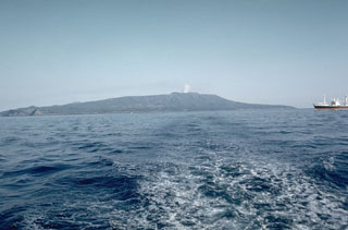 Oshima is the northernmost of the Izu Islands, seen here from the NW in Sagami Bay. The broad, low-relief volcano forms an 11 x 13 km island constructed over the remnants of three older edifices. It contains a 4-km-wide caldera containing the Miharayama cone, seen here producing a small plume in 1961, which has produced numerous recorded eruptions.
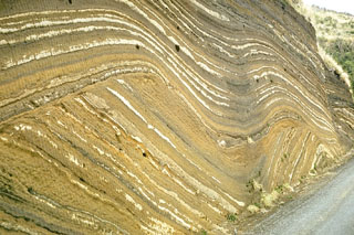 This outcrop at Oshima volcano, in the Izu Islands south of Tokyo, shows more than 100 individual tephra layers. They were produced by eruptions of Oshima at fairly regular intervals over a period of about 10,000 years. The lower layers follow the older preexisting topography. A prominent unconformity in the center of the outcrop is an erosional surface that truncated the earlier eruption deposits. The upper layers mantled this uneven surface.
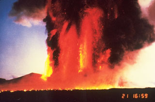 Lava fountains on 21 November 1996 reached 1.6 km above a fissure on the northern flank of Miharayama at Izu-Oshima. The horizontal line in the foreground is an advancing lava flow produced by molten ejecta from the fountains. The 1986 eruption began on 15 November with lava fountaining and lava flows lasting four days.
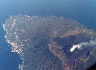 A plume rises from the crater of Miharayama on Oshima island. It lies within a 4-km-wide caldera, the rim of which is prominently visible in this aerial photo from the SW. Dark-colored lava flows from the 1986 eruption cover part of the caldera floor. More than 40 cones are located within the caldera and along two parallel rift zones trending NNW-SSE across the island. The port city of Motomachi on the west coast is to the left and the island's airport is at the upper left.
The following 23 samples associated with this volcano can be found in the Smithsonian's NMNH Department of Mineral Sciences collections, and may be availble for research (contact the Rock and Ore Collections Manager). Catalog number links will open a window with more information.
| Catalog Number | Sample Description | Lava Source | Collection Date |
|---|---|---|---|
| NMNH 108800 | Miharaite | MIHARA-YAMA | -- |
| NMNH 108801 | Miharaite | MIHARA-YAMA | -- |
| NMNH 108802 | Miharaite | MIHARA-YAMA | -- |
| NMNH 108964 | Olivine Basalt | -- | -- |
| NMNH 108974 | Hypersthene Basalt | MIHARA-YAMA CONE | -- |
| NMNH 112918 | Olivine Basalt | -- | -- |
| NMNH 112918 | Olivine Basalt | -- | -- |
| NMNH 112919 | Olivine Basalt | -- | -- |
| NMNH 112920 | Basalt | -- | -- |
| NMNH 112920 | Basalt | -- | -- |
| NMNH 112921 | Pyroxene Basalt | -- | -- |
| NMNH 112921 | Pyroxene Basalt | -- | -- |
| NMNH 112922 | Pyroxene Basalt | -- | -- |
| NMNH 112922 | Pyroxene Basalt | -- | -- |
| NMNH 112923 | Dacitic Pumice | -- | -- |
| NMNH 112923 | Dacitic Pumice | -- | -- |
| NMNH 112960 | Olivine Basalt | -- | -- |
| NMNH 112960 | Olivine Basalt | -- | -- |
| NMNH 112961 | Hypersthene Basalt | -- | -- |
| NMNH 112961 | Hypersthene Basalt | -- | -- |
| NMNH 112968-1 | Basalt | -- | -- |
| NMNH 112968-2 | Basalt | -- | -- |
| NMNH 116424 | Basaltic Andesite | C-11 CRATERLET | -- |
| Copernicus Browser | The Copernicus Browser replaced the Sentinel Hub Playground browser in 2023, to provide access to Earth observation archives from the Copernicus Data Space Ecosystem, the main distribution platform for data from the EU Copernicus missions. |
| MIROVA | Middle InfraRed Observation of Volcanic Activity (MIROVA) is a near real time volcanic hot-spot detection system based on the analysis of MODIS (Moderate Resolution Imaging Spectroradiometer) data. In particular, MIROVA uses the Middle InfraRed Radiation (MIR), measured over target volcanoes, in order to detect, locate and measure the heat radiation sourced from volcanic activity. |
| MODVOLC Thermal Alerts | Using infrared satellite Moderate Resolution Imaging Spectroradiometer (MODIS) data, scientists at the Hawai'i Institute of Geophysics and Planetology, University of Hawai'i, developed an automated system called MODVOLC to map thermal hot-spots in near real time. For each MODIS image, the algorithm automatically scans each 1 km pixel within it to check for high-temperature hot-spots. When one is found the date, time, location, and intensity are recorded. MODIS looks at every square km of the Earth every 48 hours, once during the day and once during the night, and the presence of two MODIS sensors in space allows at least four hot-spot observations every two days. Each day updated global maps are compiled to display the locations of all hot spots detected in the previous 24 hours. There is a drop-down list with volcano names which allow users to 'zoom-in' and examine the distribution of hot-spots at a variety of spatial scales. |
|
WOVOdat
Single Volcano View Temporal Evolution of Unrest Side by Side Volcanoes |
WOVOdat is a database of volcanic unrest; instrumentally and visually recorded changes in seismicity, ground deformation, gas emission, and other parameters from their normal baselines. It is sponsored by the World Organization of Volcano Observatories (WOVO) and presently hosted at the Earth Observatory of Singapore.
GVMID Data on Volcano Monitoring Infrastructure The Global Volcano Monitoring Infrastructure Database GVMID, is aimed at documenting and improving capabilities of volcano monitoring from the ground and space. GVMID should provide a snapshot and baseline view of the techniques and instrumentation that are in place at various volcanoes, which can be use by volcano observatories as reference to setup new monitoring system or improving networks at a specific volcano. These data will allow identification of what monitoring gaps exist, which can be then targeted by remote sensing infrastructure and future instrument deployments. |
| Volcanic Hazard Maps | The IAVCEI Commission on Volcanic Hazards and Risk has a Volcanic Hazard Maps database designed to serve as a resource for hazard mappers (or other interested parties) to explore how common issues in hazard map development have been addressed at different volcanoes, in different countries, for different hazards, and for different intended audiences. In addition to the comprehensive, searchable Volcanic Hazard Maps Database, this website contains information about diversity of volcanic hazard maps, illustrated using examples from the database. This site is for educational purposes related to volcanic hazard maps. Hazard maps found on this website should not be used for emergency purposes. For the most recent, official hazard map for a particular volcano, please seek out the proper institutional authorities on the matter. |
| IRIS seismic stations/networks | Incorporated Research Institutions for Seismology (IRIS) Data Services map showing the location of seismic stations from all available networks (permanent or temporary) within a radius of 0.18° (about 20 km at mid-latitudes) from the given location of Izu-Oshima. Users can customize a variety of filters and options in the left panel. Note that if there are no stations are known the map will default to show the entire world with a "No data matched request" error notice. |
| UNAVCO GPS/GNSS stations | Geodetic Data Services map from UNAVCO showing the location of GPS/GNSS stations from all available networks (permanent or temporary) within a radius of 20 km from the given location of Izu-Oshima. Users can customize the data search based on station or network names, location, and time window. Requires Adobe Flash Player. |
| DECADE Data | The DECADE portal, still in the developmental stage, serves as an example of the proposed interoperability between The Smithsonian Institution's Global Volcanism Program, the Mapping Gas Emissions (MaGa) Database, and the EarthChem Geochemical Portal. The Deep Earth Carbon Degassing (DECADE) initiative seeks to use new and established technologies to determine accurate global fluxes of volcanic CO2 to the atmosphere, but installing CO2 monitoring networks on 20 of the world's 150 most actively degassing volcanoes. The group uses related laboratory-based studies (direct gas sampling and analysis, melt inclusions) to provide new data for direct degassing of deep earth carbon to the atmosphere. |
| Large Eruptions of Izu-Oshima | Information about large Quaternary eruptions (VEI >= 4) is cataloged in the Large Magnitude Explosive Volcanic Eruptions (LaMEVE) database of the Volcano Global Risk Identification and Analysis Project (VOGRIPA). |
| EarthChem | EarthChem develops and maintains databases, software, and services that support the preservation, discovery, access and analysis of geochemical data, and facilitate their integration with the broad array of other available earth science parameters. EarthChem is operated by a joint team of disciplinary scientists, data scientists, data managers and information technology developers who are part of the NSF-funded data facility Integrated Earth Data Applications (IEDA). IEDA is a collaborative effort of EarthChem and the Marine Geoscience Data System (MGDS). |

