Report on Akutan (United States) — September 1990
Bulletin of the Global Volcanism Network, vol. 15, no. 9 (September 1990)
Managing Editor: Lindsay McClelland.
Akutan (United States) Several small ash emissions
Please cite this report as:
Global Volcanism Program, 1990. Report on Akutan (United States) (McClelland, L., ed.). Bulletin of the Global Volcanism Network, 15:9. Smithsonian Institution. https://doi.org/10.5479/si.GVP.BGVN199009-311320
Akutan
United States
54.134°N, 165.986°W; summit elev. 1303 m
All times are local (unless otherwise noted)
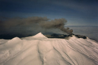
A series of small, short-lived tephra clouds from Akutan were observed in September. No ashfall was noted at Akutan village. Tephra ejection had last been reported in January. Observer's initials, in brackets, follow their information in the chronology below.
6 September: An ash plume was rising 200 m above the tephra cone in the summit caldera at 0910. By 1022, only a thin atmospheric ash layer remained, extending at least 24 km at 1,200 m altitude [RL]. At about 1220, a gray cloud reached 1,700 m altitude. Ash was again being emitted at 1330, and was drifting E [JRo].
21 September: Tephra plumes rose about 300 m above the summit at 0915 and 1345 [JRi]. Another plume was seen from Akutan village at about 1600 [MO]. At 1815, a dark gray plume rose to an altitude estimated from the ground at 2,400 m, then drifted NE [JRi]. A tephra column ejected at about 2030 that was initially black, then faded to a brown tone, grew into a mushroom-shaped cloud that reached approximately 2,400 m above the volcano [MO]. Observers from the village estimated that each of the day's plumes had risen at least 1,200 m.
22 September: A small tephra plume rose about 150 m at 1030. Steam emission was above normal through the day [JRi].
Several similar small tephra clouds were seen during the following days, but no records were kept of dates and times.
30 September: A very dark black plume ejected at 2005 rose about 1,800 m and drifted E toward Akutan village [DH].
1 October: At 1055, a dark black cloud rapidly emerged and reached 1,500 m above the summit before moving E. After the initial burst, the plume weakened to a light brown color. Activity was apparently limited to emission of a 60-m steam plume for the rest of the day [MO].
Observers (initials in brackets): David Hamilton and Mark Owen (Trident Seafood, Akutan village); Robert LeBlanc, Jerry Richardson, and Jean Robert (MarkAir).
Geological Summary. Akutan contains a 2-km-wide caldera with a large cinder cone in the NE part of the caldera that has been the source of frequent explosive eruptions and occasional lava effusion that covers the caldera floor. An older, largely buried caldera was formed during the late Pleistocene or early Holocene. Two volcanic centers are located on the NW flank. Lava Peak is of Pleistocene age, and a cinder cone lower on the flank produced a lava flow in 1852 that extended the shoreline of the island and forms Lava Point. The 60-365 m deep younger caldera was formed during a major explosive eruption about 1,600 years ago and contains at least three lakes. A lava flow in 1978 traveled through a narrow breach in the north caldera rim almost to the coast. Fumaroles occur at the base of the caldera cinder cone, and hot springs are located NE of the caldera at the head of Hot Springs Bay valley and along the shores of Hot Springs Bay.
Information Contacts: J. Reeder, ADGGS.