Report on Asamayama (Japan) — December 1990
Bulletin of the Global Volcanism Network, vol. 15, no. 12 (December 1990)
Managing Editor: Lindsay McClelland.
Asamayama (Japan) Steam emission and seismicity
Please cite this report as:
Global Volcanism Program, 1990. Report on Asamayama (Japan) (McClelland, L., ed.). Bulletin of the Global Volcanism Network, 15:12. Smithsonian Institution. https://doi.org/10.5479/si.GVP.BGVN199012-283110
Asamayama
Japan
36.406°N, 138.523°E; summit elev. 2568 m
All times are local (unless otherwise noted)
Frequent seismicity . . . has declined since late October (figure 12). In December, 33 earthquakes but no tremor episodes were recorded, compared to 27 and 1, respectively, in November. Steam emission continued at levels similar to November, reaching 600 m above the summit.
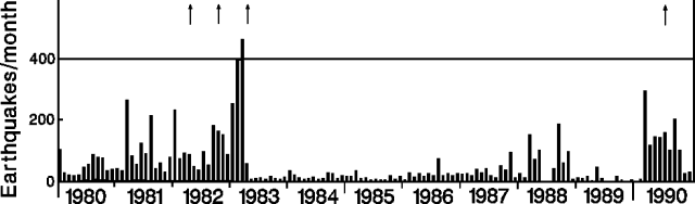 |
Figure 12. Monthly number of earthquakes at Asama 1980-90. Arrows mark eruptions. Courtesy of JMA. |
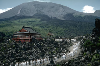
Geological Summary. Asamayama, Honshu's most active volcano, overlooks the resort town of Karuizawa, 140 km NW of Tokyo. The volcano is located at the junction of the Izu-Marianas and NE Japan volcanic arcs. The modern Maekake cone forms the summit and is situated east of the remnant of an older andesitic volcano, Kurofuyama, which was destroyed by a late-Pleistocene landslide about 20,000 years before present (BP). Growth of a dacitic shield volcano was accompanied by pumiceous pyroclastic flows, the largest of which occurred about 14,000-11,000 BP, and by growth of the Ko-Asamayama lava dome on the east flank. Maekake, capped by the Kamayama pyroclastic cone that forms the present summit, is probably only a few thousand years old and has observed activity dating back at least to the 11th century CE. Maekake has had several major Plinian eruptions, the last two of which occurred in 1108 (Asamayama's largest Holocene eruption) and 1783 CE.
Information Contacts: JMA.