Report on Colima (Mexico) — December 1990

Bulletin of the Global Volcanism Network, vol. 15, no. 12 (December 1990)
Managing Editor: Lindsay McClelland.
Colima (Mexico) Strong fumarolic activity; most local seismicity apparently tectonic
Please cite this report as:
Global Volcanism Program, 1990. Report on Colima (Mexico) (McClelland, L., ed.). Bulletin of the Global Volcanism Network, 15:12. Smithsonian Institution. https://doi.org/10.5479/si.GVP.BGVN199012-341040
Colima
Mexico
19.514°N, 103.62°W; summit elev. 3850 m
All times are local (unless otherwise noted)
The following is a report from Ana Lillian Martín. "In 1981 when we first observed the dome morphology, it was made up of several-meter blocks divided by deep cracks in which some fumaroles were active. The 1981-82 lava flow breached the S rim and produced a thick, blocky, but short flow accompanied by small Merapi-type avalanches (roughly once every 15 minutes). Three years ago [on 2 July 1987], an explosion on the E part of the dome opened a 30 x 20 m crater (15 m deep) [but see larger estimated dimensions in 13:09 and 14:06] and produced a small black cloud (see 12:07 and 13:09). In 1988 and 1989, oversteepening on the dome generated small landslides on the volcano, mainly to the S and W. During 1990, the landslides seem to have increase slightly. Landsliding (arrows on figure 8) is marked by <10-m amphitheater-shaped scars on the dome and occurs more frequently on the S flank, where the slope steepens sharply. W-slope landslides entered tributaries of the Río Lumbre ('fire') but remained on the upper flanks. Irregular, changing dome topography included protrusions up to 20 m high, of which the one on the N side seems to be rising. Depressions are about 10 m deep, but only one (on the W side) contains fumaroles. The main fumarolic area was in the NE part of the crater, possibly on the crater-dome boundary, where rocks were covered by sulfur crystals from the fumaroles. In October, fumarolic activity was more widespread, probably related to rain. Spring-water monitoring (January-November) has shown no evidence that could suggest variations in activity."
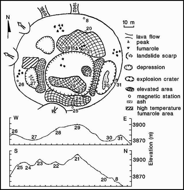 |
Figure 8. Sketch map, with E-W and N-S cross-sections, of Colima's summit crater in May 1990. Selected fumaroles (those with the most vigorous plumes) are shown. The area of high-temperature fumaroles measured by Connor and others is indicated by a shaded box in the W part of the crater. Courtesy of Ana Lillian Martín. |
The following is from Guillermo Castellanos. "On 1 December, a group from CICBAS, Universidad de Colima, and CTS Cinvestav Guadalajara, visited Colima to provide maintenance to EZV3, the 5th seismological station of the Red Sismológica Telemétrica del Estado de Colima (RESCO), put in service on 24 May 1989 by the Grupo de Sismología del CICBAS, Universidad de Colima. New, strong fumarolic activity has been observed since a couple of months ago. During the visit, emissions from the three main fumarole areas were intense, although it seems that the emissions are mainly water vapor. Reports of this activity from Ciudad Guzmán and Colima have been alarming the inhabitants of the region. Careful analysis of data recorded by RESCO has shown that the seismic activity is mainly of tectonic origin (figure 9). A detailed study of seismic activity in Colima as recorded by RESCO is in progress and the results will be reported in future communications. RESCO is a project partially supported by the Gobierno del Estado de Colima, DGICSA-SESIC-SEP, and CONACYT-MEXICO."
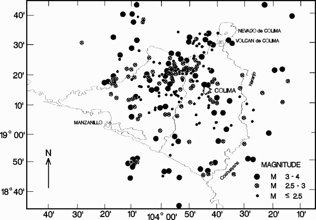 |
Figure 9. Seismicity near Colima volcano, recorded January-September 1990 by RESCO seismic stations. Courtesy of Guillermo Castellanos. |
The following is from Charles Connor. "FIU geologists and personnel from the Mexican Red Cross visited the summit dome on 16 and 18 December. Degassing rates were clearly greater than in March and May. Widespread fumarolic activity on the dome has resulted in sulfur deposition over a larger area than previously seen. Fumaroles also existed at lower elevations than we observed earlier this year. Temperatures of all these new fumaroles are low (65-155°C), suggesting that the change in fumarolic activity may be a seasonal effect rather than being associated with renewed magmatic activity. The highest-temperature fumaroles we observed are on the W side of the dome, in an area of ~400 m2, along NE-trending fractures. Several new fumaroles in this area had temperatures of >500°C, but none were hotter than 550°C, a temperature range similar to that observed in March and May. Temperatures in three fumaroles in this area were recorded at 2-minute intervals over a 42-hour period. The highest-temperature fumarole (figure 10, number 3) is located in a fracture ~10 cm wide. Cooler fumaroles are located 10 and 15 m peripheral to these fractures. These fumaroles had temperature variations of up to 55°C in 6 hours during the sampling period. In general, these lower-temperature fumaroles also had lower mass flows than nearby higher-temperature fumaroles.
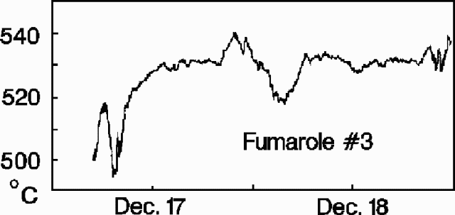 |
Figure 10. Temperature profile at a fumarole (number 3) on the W side of the summit dome at Colima, 16-18 December 1990. Courtesy of C. Connor. |
"Although there have been some changes at the summit dome since our last report in March, they appear to be seasonal and there is no indication of renewed magmatic activity at this time. Avalanche hazards associated with the volcano remain very high where the volcano is oversteepened and highly fractured, particularly on the S and NW faces of the dome. Low-temperature fumaroles are concentrated along many of these fractures.
Geological Summary. The Colima complex is the most prominent volcanic center of the western Mexican Volcanic Belt. It consists of two southward-younging volcanoes, Nevado de Colima (the high point of the complex) on the north and the historically active Volcán de Colima at the south. A group of late-Pleistocene cinder cones is located on the floor of the Colima graben west and east of the complex. Volcán de Colima (also known as Volcán Fuego) is a youthful stratovolcano constructed within a 5-km-wide scarp, breached to the south, that has been the source of large debris avalanches. Major slope failures have occurred repeatedly from both the Nevado and Colima cones, producing thick debris-avalanche deposits on three sides of the complex. Frequent recorded eruptions date back to the 16th century. Occasional major explosive eruptions have destroyed the summit (most recently in 1913) and left a deep, steep-sided crater that was slowly refilled and then overtopped by lava dome growth.
Information Contacts: Ana Lillian Martín del Pozzo, Instituto de Geofísica, UNAM; Guillermo Castellanos, Gilberto Ornelas-Arciniega, C.A. Ramírez-Vázquez, G.A. Reyes-Dávila, and H. Tamez, CICBAS, Universidad de Colima; Zenón Jimenez and M.A. Arévalo, Instituto de Geofísica, UNAM, Circuito Exterior; C.B. Connor and Sammantha B. Lane, Florida International Univ, USA; Mitchell Ventura and Cruz Roja Mexicana, Delegación en Colima, Colima, México.