Report on Unzendake (Japan) — March 1991

Bulletin of the Global Volcanism Network, vol. 16, no. 3 (March 1991)
Managing Editor: Lindsay McClelland.
Unzendake (Japan) Ash emissions continue from three vents
Please cite this report as:
Global Volcanism Program, 1991. Report on Unzendake (Japan) (McClelland, L., ed.). Bulletin of the Global Volcanism Network, 16:3. Smithsonian Institution. https://doi.org/10.5479/si.GVP.BGVN199103-282100
Unzendake
Japan
32.761°N, 130.299°E; summit elev. 1483 m
All times are local (unless otherwise noted)
Steam and ash emissions from the vent (Byobu-iwa) formed during the 12 February eruption continued through mid-April (table 5). Maximum plume heights were 300 m in March and 500 m in early April (figure 14). Ash had been erupted 16-20 March after steam emission increased. Simultaneous eruptions at Byobu-iwa and the two vents formed in the 17 November eruption (Jigoku-ato and Tsukumo-jima) were observed on 29 March and 3 and 9 April. All previous emissions had been confined to Byobu-iwa following the February eruption.
Table 5. Dates of ash emissions at Unzen, November 1990-12 April 1991. Courtesy of JMA.
| Eruption Date | Plume Height | Main Vent |
| 17-23 Nov 1990 | 400 m | Tsukumo, Jigoku-ato |
| 12-27 Feb 1991 | 500 m | Byobu-iwa |
| 16-20 Mar 1991 | 300 m | Byobu-iwa |
| 23 Mar 1991 | 200 m | Byobu-iwa |
| 29 Mar 1991 | 200 m | Byobu-iwa |
| 03 Apr 1991 | 300 m | Byobu-iwa |
| 09 Apr 1991 | 500 m | Jigoku-ato |
| 12 Apr 1991 | 200 m | Byobu-iwa |
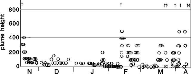 |
Figure 14. Plume heights at Unzen, November 1990-early April 1991. Arrows mark eruptions. Courtesy of JMA. |
A swarm of 298 earthquakes, including 11 felt [at UWS], was recorded on 3 March (figure 15). March seismicity totaled 734 recorded earthquakes and 21 felt shocks (see table 4). Most were located a few kilometers W of Fugendake peak, the primary epicentral area since July 1990. Tremor episodes declined from 137 in February to 99 in March, ranging from 0-8/day (figure 15).
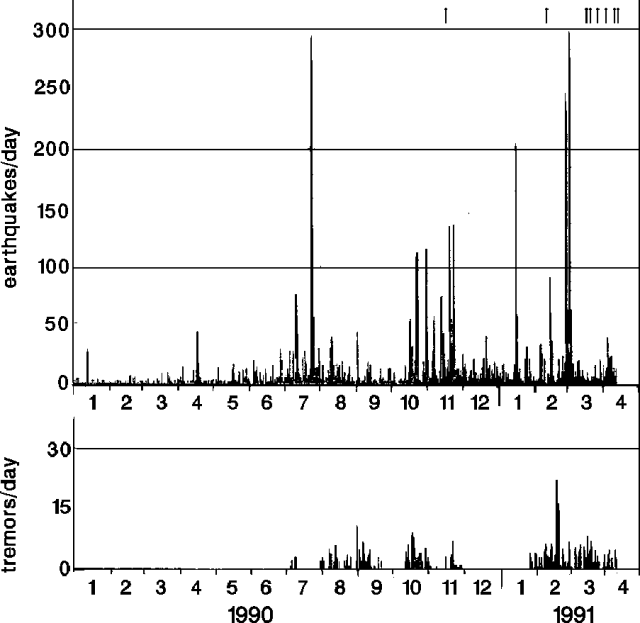 |
Figure 15. Daily number of recorded earthquakes (top) and tremor episodes (bottom) at Unzen, January 1990-early April 1991. Arrows mark eruptions. Courtesy of JMA. |
Geological Summary. The massive Unzendake volcanic complex comprises much of the Shimabara Peninsula east of the city of Nagasaki. An E-W graben, 30-40 km long, extends across the peninsula. Three large stratovolcanoes with complex structures, Kinugasa on the north, Fugen-dake at the east-center, and Kusenbu on the south, form topographic highs on the broad peninsula. Fugendake and Mayuyama volcanoes in the east-central portion of the andesitic-to-dacitic volcanic complex have been active during the Holocene. The Mayuyama lava dome complex, located along the eastern coast west of Shimabara City, formed about 4000 years ago and was the source of a devastating 1792 CE debris avalanche and tsunami. Historical eruptive activity has been restricted to the summit and flanks of Fugendake. The latest activity during 1990-95 formed a lava dome at the summit, accompanied by pyroclastic flows that caused fatalities and damaged populated areas near Shimabara City.
Information Contacts: JMA; AP.