Report on Ontakesan (Japan) — April 1991
Bulletin of the Global Volcanism Network, vol. 16, no. 4 (April 1991)
Managing Editor: Lindsay McClelland.
Ontakesan (Japan) Earthquake swarms and tremor; no change in steam emission
Please cite this report as:
Global Volcanism Program, 1991. Report on Ontakesan (Japan) (McClelland, L., ed.). Bulletin of the Global Volcanism Network, 16:4. Smithsonian Institution. https://doi.org/10.5479/si.GVP.BGVN199104-283040
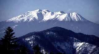
Ontakesan
Japan
35.893°N, 137.48°E; summit elev. 3067 m
All times are local (unless otherwise noted)
Three earthquake swarms (20, 23, and 27 April) and four tremor episodes (27-28 April and 2 May) were recorded during late April-early May. The strongest swarm, on 20 April, lasted a few hours and included a M 1.6 event. None of the shocks were felt, and it was not possible to locate them accurately, but they were believed to be in the summit area. The 27 April tremor episode was the largest (table 1), and accompanying seismicity was the strongest registered (figure 5), since installation of the current seismometer, in July 1988.
Table 1. Tremor episodes recorded at On-take, 15 July 1988-11 May 1991.
| Date | Time | Amplitude (N) | Duration (min) |
| 02 Oct 1988 | 0132 | 0.1 | 1 |
| 06 Oct 1988 | 1035 | 0.1 | 1 |
| 12 Jan 1989 | 1725 | 0.6 | 1 |
| 19 Aug 1989 | 1313 | 0.4 | 2 |
| 11 Apr 1990 | 1808 | 0.2 | 2 |
| 27 Apr 1991 | 0716 | 2.3 | 4 |
| 27 Apr 1991 | 1201 | 0.1 | 2 |
| 28 Apr 1991 | 1309 | 1.4 | 3 |
| 02 May 1991 | 0938 | 0.3 | 3 |
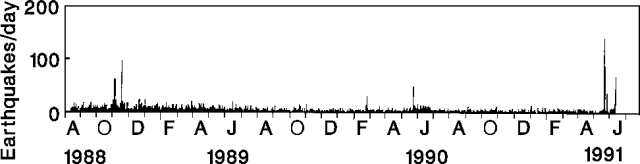 |
Figure 5. Daily number of recorded earthquakes at On-take, 15 July 1988-5 May 1991. Courtesy of JMA. |
White steam emissions, unchanged from previous months (figure 6), rose 200 m from summit vents formed during a small phreatic eruption in October 1979. That eruption emitted ash for 1 day; steam emission declined, but has remained steady since then.
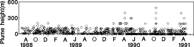 |
Figure 6. Plume heights at On-take, 20 July 1988-13 May 1991. Courtesy of JMA. |
A M 6.8 earthquake, 12 km SE of the summit on 14 September 1984, triggered a landslide on the S slope of the volcano that killed 29 people. Aftershocks were distributed on the volcano's S flank in an elliptical zone that may mark a 20-km-long WSW-ENE fault (figure 7). Steam emission and surface activity were unchanged by the 1984 earthquake.
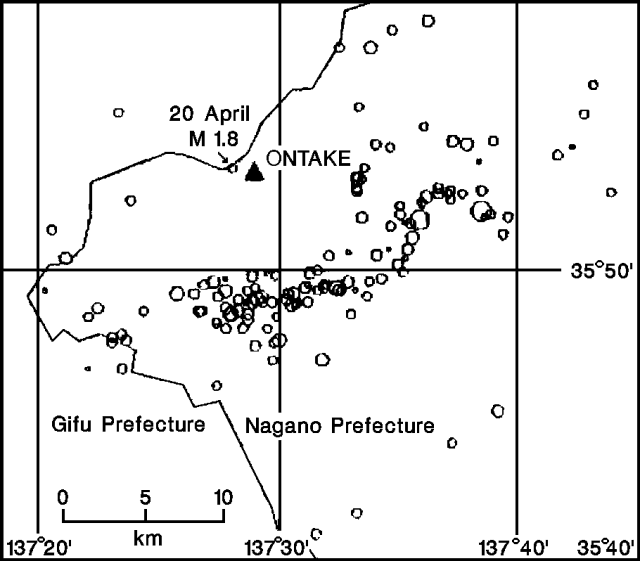 |
Figure 7. Epicenter map of 138 earthquakes at On-take, January 1990-May 1991. Locations of the three swarms are not shown, but are considered to be in the summit area (triangle). The largest shock, M 1.8, was centered just W of the summit. The group of events in an E-W line 15 km S of the summit are aftershocks from a M 6.8 earthquake in 1984. Courtesy of JMA. |
Geological Summary. The massive Ontakesan stratovolcano, the second highest volcano in Japan, lies at the southern end of the Northern Japan Alps. Ascending this volcano is one of the major objects of religious pilgrimage in central Japan. It is constructed within a largely buried 4 x 5 km caldera and occupies the southern end of the Norikura volcanic zone, which extends northward to Yakedake volcano. The older volcanic complex consisted of at least four major stratovolcanoes constructed from about 680,000 to about 420,000 years ago, after which Ontakesan was inactive for more than 300,000 years. The broad, elongated summit of the younger edifice is cut by a series of small explosion craters along a NNE-trending line. Several phreatic eruptions post-date the roughly 7300-year-old Akahoya tephra from Kikai caldera. The first historical eruption took place in 1979 from fissures near the summit. A non-eruptive landslide in 1984 produced a debris avalanche and lahar that swept down valleys south and east of the volcano. Very minor phreatic activity caused a dusting of ash near the summit in 1991 and 2007. A significant phreatic explosion in September 2014, when a large number of hikers were at or near the summit, resulted in many fatalities.
Information Contacts: JMA.